
|
Click here to see the home page and learn about swimming holes in other states
See a SLIDESHOW of swimming hole photos in this state.
This swimming hole listing is by www.swimmingholes.org
|
TOWNS | DOTHAN, COLUMBIA, ABBEVILLE | LAT LON : | lat=31.412239, lon=-85.079503(source:
DeLorme) (accuracy:exact) | LINK TO GOOGLE MAP
STATE | AL |
WATER | Chattahoochee River |
TYPE | River |
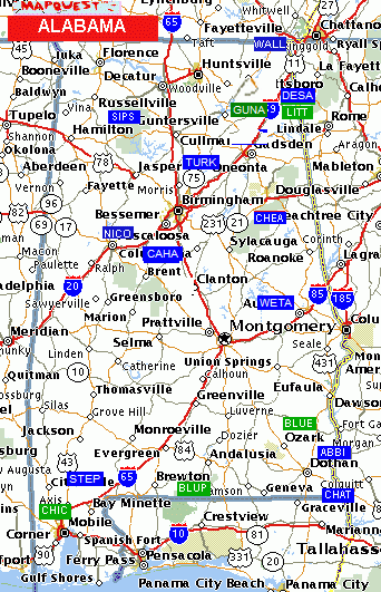
DESCRIPTION | It is hard to find a safe place to swim in the
Chattahoochee in this area; the currents are swift and access is infrequent.
At Abbie Creek Park, there is a boat ramp into Abbie Creek just where it
empties into the Chattahoochee. One can swim at the foot of the boat ramp
where there is little current. |
AREAS | Abbie Creek Park |
SANCTION | Unofficial |
FEE | None |
FACILITIES |
None |
ACTIVITIES |
Swimming |
PHONE | None |
CAMPING | None at site. Blue Springs S.P. and Lakepoint State Resort
Park are both not too far from here and have camping. |
BATHING SUITS | Unknown |
DIRECTIONS | From Dothan, go about 20 mi northeast on RT 52 to
Columbia. Then north on RT 95 and follow signs to Abbie Creek Park. (This is
in the southeast corner of AL.) |
CONFIDENCE | Very confident |
VERIFIED | Yes |
DATE UPDATED | 5/7/2000 | |
|---|
This swimming hole listing is by www.swimmingholes.org
|
TOWNS | ANDALUSIA, CAROLINA | LAT, LON | lat=31.1125, lon=-86.55278(source:Topozone)
(accuracy:exact) | LINK TO GOOGLE MAP
STATE | AL |
WATER | Blue Pond |
TYPE | Spring |
DESCRIPTION | A clear, cool spring-fed pond in a Conecuh National
Forest Recreation Area with sandy beach and (perhaps) lifeguards in season?
Hiking trails and camping nearby. |
AREAS | Conecuh National Forest Recreation Area |
SANCTION | Official |
FEE | Unknown |
FACILITIES |
Unknown |
ACTIVITIES |
Swimming |
PHONE | Unknown |
CAMPING | Nearby at the Open Pond Recreation Area |
BATHING SUITS | Required |
DIRECTIONS | From Andalusia (in south central AL) go south on RT 29/15
toward the Conecuh N. F.. Turn south (left) on RT 137 near the entrance to
the N.F.. After about 5-6 miles, look for signs to the Blue Pond Recreation
Area on the east (left) side of RT 137. The swimming place is in Blue Pond. |
CONFIDENCE | Very confident |
VERIFIED | No |
DATE UPDATED | 2/20/2003 | |
|---|
This swimming hole listing is by www.swimmingholes.org
|
TOWNS | DOTHAN, CLIO
| LAT LON | lat=31.66158, lon=-85.50742(source:
DeLorme) (accuracy: exact) | LINK TO GOOGLE MAP
STATE | AL |
WATER | Blue Spring |
TYPE | Spring |
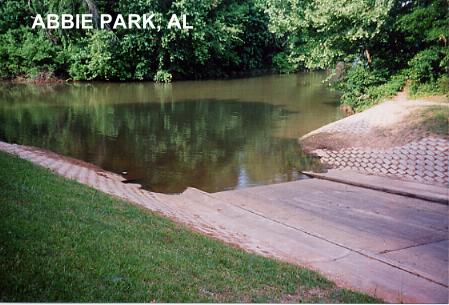
DESCRIPTION | A clear, cool spring is led into a concrete-sided pool
with a natural bottom. This from a visitor in 2007:"The spring area is
divided into two sections, the upper & lower sections. The upper section is
between 4 to 20ft.deep and the lower section is 3.5ft. to 5ft. deep. There
is a nice clean wading area where it flows to the river that is about 2ft.
deep for small children." Very nice water and swimming. The spring empties
immediately into the Choctawatchee River but there is no apparent swimming
place in the river itself. Blue Springs is very similar to some springs in
Florida, like DeLeon or Juniper Springs. |
AREAS | Blue Springs State Park |
SANCTION | Official |
FEE | $3.00 per person (2007). |
FACILITIES |
Full facilities in State Park |
ACTIVITIES |
Swimming |
PHONE | (334)397-4875 (State Park) |
CAMPING | At site (334)397-4875 |
BATHING SUITS | Required |
DIRECTIONS | From Dothan, take RT 431 N to Abbeville, then RT 10 NW
to Blue Springs S. P.. (There was a detour on RT 10 in 5/2000, a bridge is
out- this adds about 8 miles to the distance.) |
CONFIDENCE | Very confident |
VERIFIED | Yes |
DATE UPDATED | 5/16/2000 | |
|---|
This swimming hole listing is by www.swimmingholes.org
|
TOWNS | BIRMINGHAM |
STATE | AL |
WATER | Cahaba River |
TYPE | River |
DESCRIPTION | Several swimming place in the Cahaba River not far from
Birmingham. For details, see DIRECTIONS below. |
AREAS | Unknown |
SANCTION | Unofficial |
FEE | Varies - see below |
FACILITIES |
Unknown |
ACTIVITIES |
Swimming, Rope swing, tubing |
PHONE | Varies - see below |
CAMPING | Commercial camping along river at Limestone Park. |
BATHING SUITS | Unknown |
DIRECTIONS | Directions below are from Birmingham: | GRANTS MILL RD [GRAN]: Swimming place with rope swing in Cahaba River in Irondale, just east of Birmingham. YOUTUBE . To get here from Birmingham, go east on I-20 to Exit 133 then take Grants Mill Rd. east for about 5 miles to the bridge over the Cahaba River. The swimming place is here near the bridge. No better directions. LAT, LON lat=33.51149, lon=-86.65260(source: Map) (accuracy:approximate) LINK TO GOOGLE MAP. Pretty confident. Not verified. Updated 3/2013. LIMESTONE PARK [LIME]: This from a visitor: "Huge college kid hang out. There is a rental place there and they rent tubes mostly but they have an extra long canoe trip too. The camping is set next to a bend in the Cahaba river where a small waterfall sends everyone off there tubes. The water is cold year round but you just stick your cooler in a tube and after a few sandbar stops you don't even notice it." Phone for rental and camping place: 205-926-9672. To get here from Birmingham, go south on I-65 for about 23 miles then take Exit 238 toward Alabaster. Take RT 119 south about 12 miles then turn right onto RT 25. Go about 8 miles then turn right onto Bulldog Bend Rd. Go 2 miles then turn right onto Cahaba Valley Rd and keep left onto Limestone Pkwy and go about 1 mile to the river. LAT, LON lat=33.05350, lon=-86.99666(source: Map) (accuracy:approximate) LINK TO GOOGLE MAP. Pretty confident. Not verified. Updated 3/2013.
CONFIDENCE | Pretty confident |
VERIFIED | No |
DATE UPDATED | 3/2013 | |
|---|
This swimming hole listing is by www.swimmingholes.org
|
TOWNS | DOTHAN, GORDON | LAT
LON | lat=31.00478, lon=-85.03464(source: DeLorme) (accuracy:
approximate) | LINK TO GOOGLE MAP
STATE | AL |
WATER | Unknown |
TYPE | Lake |
DESCRIPTION | Swim from a boat dock in a picturesque, small lake. (Be
careful- may be alligators present). |
AREAS | Chattahoochee State Park |
SANCTION | Unofficial |
FEE | None |
FACILITIES |
Full facilities in State Park |
ACTIVITIES |
Swimming |
PHONE | (354)522-3607(State Park) |
CAMPING | At site (354)522-3607 |
BATHING SUITS | Required |
DIRECTIONS | From Dothan, 26 mi southeast on RT 84 then south on RT
95 to the state park. (This is in the extreme southeast corner of AL.) When
you enter the park, go to the right and over a small dam. There is a boat
ramp and a wooden dock. Swim from the dock. (Be careful-there may be
alligators present.) |
CONFIDENCE | Very confident |
VERIFIED | Yes |
DATE UPDATED | 5/7/2000 | |
|---|
This swimming hole listing is by www.swimmingholes.org
|
TOWNS | BIRMINGHAM, ANNISTON, TALLADEGA | LAT LON | lat=33.468, lon=-85.883(source:
Topozone) (accuracy:general area) | LINK TO GOOGLE MAP
STATE | AL |
WATER | Cheaha Creek/ High Falls Branch |
TYPE | Falls/River |
DESCRIPTION | Several swimming holes in pools at the bottom of falls
in the Talladega N. F. near Cheaha Mountain. For details, see "directions"
below. |
AREAS | Lake Chinnabee Recreation Area, Talladega N. F., Cheaha State
Park. |
SANCTION | Unofficial |
FEE | None |
FACILITIES |
Cheaha State Park is very nearby and has all facilities. |
ACTIVITIES |
Swimming |
PHONE | None |
CAMPING | At Talladega Campground (NF) also at Cheaha State Park |
BATHING SUITS | Possibly optional; some places are very isolated, see
descriptions |
DIRECTIONS | From Birmingham, take I-21 east just past Anniston then
Rt 431 south at exit 191. Take RT 431 south a short way then turn south
(right) on RT 281, the Cheaha Skyway. Follow this very scenic drive south
toward Cheaha State Park until where RT 49 goes off to the left. Then: |
CHEAHA FALLS [CHEF]: Continue on the above trail to about 3 miles
from the trailhead where it gets to the Cheaha Falls Shelter. Go past the
shelter and downhill to the creek, wade across it here and go downstream
from here to a number of waterfalls, including Cheaha Falls, which has a
large swimming pool at the bottom. LAT, LON (drive to) lat=33.4591, lon=-85.8738(source:
Measured) (accuracy:exact)
LINK TO GOOGLE MAP. LAT, LON (hike to) lat=33.4525, lon=
-85.8738(source: web site) (accuracy:approximate)
LINK TO GOOGLE MAP. Pretty confident. Not verified. Updated 10/08.
CONFIDENCE | See above |
VERIFIED | No |
DATE UPDATED | 6/2019 | |
|---|
This swimming hole listing is by www.swimmingholes.org
|
TOWNS | MONTGOMERY, AUBURN |
LAT LON | lat=32.54861, lon=-85.47843(source: DeLorme) (accuracy:
approximate) | LINK TO GOOGLE MAP
STATE | AL |
WATER | Chewacla Creek |
TYPE | Creek/Falls |
DESCRIPTION | Swim in
Chewacla State Park at the lower falls hole (the park also has an
official lake swimming beach). Perfect depth and size, about 6 feet deep,
where two streams meet.; About 10 yards across and maybe 30 yards long.;
Average depth is about knee high (2 feet maybe?) with a deeper hole going
down to about 6 feet. Perfect place to take the dogs and let 'em play fetch
and swim. |
AREAS | Chewacla State Park (124 Shell Toomer Pkwy., Auburn, AL 36830) |
SANCTION | Unofficial in creek (also official lake swimming) |
FEE | Unknown |
FACILITIES |
Unknown |
ACTIVITIES |
Swimming |
PHONE | 334-887-5621 (park) |
CAMPING | Developed camping at site |
BATHING SUITS | Unknown |
DIRECTIONS | From Montgomery take I-85 east to exit 51 then RT 29 (S.
College St.) south. In a very short distance, turn east (left) on RT 863
(Shell Toomer Pkwy). Continue on Shell Toomer and enter the park. In the
park, continue straight onto Murphy's Rd.. Follow Murphy's Rd. as it bends
to the right and go to the very end of Murphy's Rd.. Take a trail down to
the falls and swim, or hike up around the falls and swim in the lake. |
CONFIDENCE | Pretty confident |
VERIFIED | By another, 8/12014 |
DATE UPDATED | 8/2014 | |
|---|
This swimming hole listing is by www.swimmingholes.org
|
TOWNS | MOBILE, CHICKASAW |
LAT LON | lat=30.78269, lon=-88.10261(source: DeLorme) (accuracy:
approximate) | LINK TO GOOGLE MAP
STATE | AL |
WATER | Chickasaw Creek (?) |
TYPE | Creek |
DESCRIPTION | The following description thanks to R. Jones, Parks &
Wildlife Manager, Mobile County: "Chickasabogue Park is a 1200 acre Mobile
County, Al outdoor recreation facility with a very nice cold, clear but dark
water stream (tannic color) with sugar white sand bars. It is one of the few
streams in this part of the state that remain cool and refreshing even in
the dog days of summer. There is a roped off swim area popular with locals
in the summer and large white sand bars upstream and downstream from there
reachable by canoe or boat for a more private swimming experience. The Park
rents canoes for $5 per hour and $20 all day." |
AREAS | Chickasabogue Park |
SANCTION | Official |
FEE | $1.00 admission |
FACILITIES |
Full facilities |
ACTIVITIES |
Swimming |
PHONE | 251-574-2267 |
CAMPING | At site |
BATHING SUITS | Required |
DIRECTIONS | From Mobile, go north a few miles on I-65 to exit 13.
Follow signs to the park. |
CONFIDENCE | Very confident |
VERIFIED | Verified by operator |
DATE UPDATED | 6/3/2008 | |
|---|
This swimming hole listing is by www.swimmingholes.org
|
TOWNS | BIRMINGHAM, ANNISTON, OXFORD |
LAT LON | lat=33.59678, lon=-85.92356 (source: DeLorme)
(accuracy: approximate) | LINK TO GOOGLE MAP
STATE | AL |
WATER | Coldwater Creek |
TYPE | Creek |
DESCRIPTION | Long time swimming hole that has been turned into a
public park where people regularly still play in the creek. Mostly very
shallow, deeper near the bridge. Lots of families hang out here. |
AREAS | Coldwater Creek Park |
SANCTION | Official |
FEE | Unknown |
FACILITIES |
Unknown |
ACTIVITIES |
Swimming |
PHONE | Unknown |
CAMPING | None at site |
BATHING SUITS | Required |
DIRECTIONS | From Birmingham, go east on I-20 to exit 179 (Coldwater
Creek) then go north to RT 78. Turn right onto RT 78 and take the first left
(Scott Drive) down into the park's parking lot. The swimming hole is between
Cecil Drive and RT 78. Very public. |
CONFIDENCE | Very confident |
VERIFIED | No |
DATE UPDATED | 1/23/2008 | |
|---|
This swimming hole listing is by www.swimmingholes.org
|
TOWNS | ANNISTON, GADSDEN, CHATTANOOGA (TN) |
STATE | AL |
WATER | West Fork Little River |
TYPE | River/Falls |
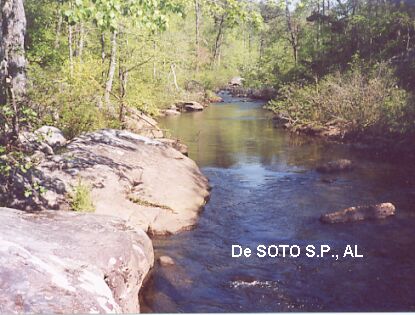
DESCRIPTION | Desoto State Park is a "resort" park, with lodge,
restaurant, camping and other amenities. Nearby is Desoto Falls, which are
awesome. For details, see DIRECTIONS below. |
AREAS | Desoto State Resort Park |
SANCTION | Unofficial |
FEE | None |
FACILITIES |
Full facilities at the State Park lodge. |
ACTIVITIES |
Swimming |
PHONE | (205) 845-0051 (State Park) |
CAMPING | At site (205) 845-5075 |
BATHING SUITS | Customary |
DIRECTIONS | From Gadsden, take I-59 north about 35 mi to Ft. Payne.
From Ft. Payne, follow RT 35 east to the top of Lookout Mtn. Then north
(left) on RT 89 to Desoto S.P.. (See area map.) Then: | DESOTO STATE PARK [DESP]: Behind the State Park lodge, there is a network of trails that lead quickly down to the West Fork Little River and there are several nice swimming places here with large flat rocks to sun on and swim from. PHOTO. To get here, drive into the State Park and follow signs to the lodge and park. Follow the "white" trail behind the lodge, down to the "yellow" trail which goes along the river. Follow the river upstream and look for large, flat rocks with deep places in the river below. LAT LON: lat=34.50132, lon=-85.61886(source: Map) (accuracy: approximate) LINK TO GOOGLE MAP. Very confident. Verified. Updated 2/2014. DESOTO FALLS [DESF]: Nearby is Desoto Falls, which is awesome, with a huge pool at the bottom of the falls. It is a very difficult and dangerous climb to get to the bottom. We do not include directions here for that reason. LAT LON: lat=34.55040, lon=-85.59091(source: Map) (accuracy: approximate) LINK TO GOOGLE MAP. Very confident. Verified by another. Updated 2/2014.
CONFIDENCE | Very confident |
VERIFIED | Yes |
DATE UPDATED | 2/2014 | |
|---|
This swimming hole listing is by www.swimmingholes.org
|
TOWNS | FORT PAYNE, GUNTERSVILLE, GERALDINE, ALBERTVILLE |
STATE | AL |
WATER | Varies - see below |
TYPE | Varies - see below |
DESCRIPTION | |
AREAS | Varies - see below |
SANCTION | Unofficial |
FEE | Unknown |
FACILITIES |
Unknown |
ACTIVITIES |
Swimming, Jumping |
PHONE | Unknown |
CAMPING | No camping at sites |
BATHING SUITS | Customary |
DIRECTIONS | From Birmingham take I-59 north to Exit 205. Take RT
68 west to Crossville, then | HIGH FALLS PARK [HIGF]: Falls in Town Creek. This report from a visitor in 2010: "It was incredible! There is a very shallow area at the top when you first get into the park that's good to wade around in...it's good for kids/family, I'd say. That creek then spills over onto the rocks that create the falls. There is a beautiful, naturally formed stone bridge that people jump from (about 20-30 feet high). I think the water level was somewhat low as most of the places on the rocks where water would cascade over were dry so there was just the one BIG fall and then a few other little ones." "There is a rock walkway (carved from the falls) that you have to walk down if you don't want to jump to get down. The rocks can be a bit dangerous if they're slippery, people need to be wary of that. Below the falls is gorgeous, and the swimming is great! The swimming hole is plenty deep in most places, just got to be wary of jumping too close to the shore where it is more shallow. The cliff jumping is what makes this place special and fun, in my opinion. The jumps range from about 5 ft to 42 or so feet. Here's some YOUTUBE we took". From Crossville (above) take RT 227 north through Geraldine and follow the signs to High Falls Park where RT 227 crosses Town Creek. LAT, LON lat= 34.39073, lon=-86.01836(source: Map) (accuracy:approximate) LINK TO GOOGLE MAP. Pretty confident. Not verified. Updated 3/2013. OLD RED MILL [OLDR]: Swimming and jumping place near old mill in creek. YOUTUBE . DO NOT SWIM HERE IF WATER FLOW IS HIGH. To get here from Crossville (above), continue west on RT 68 about 10 miles then continue onto Co Rd 414/Hustleville Rd and go about 1.5 mi then turn right onto Co Rd 409/Martling Rd and go about 1.2 miles to Old Red Mill near where Martling Rd. crosses 2 creeks. LAT, LON lat= 34.3264, lon=-86.1618(source: Map) (accuracy:approximate) LINK TO GOOGLE MAP. Pretty confident. Not verified. Updated 3/2013.
CONFIDENCE | Pretty confident |
VERIFIED | No |
DATE UPDATED | 3/2013 | |
|---|
This swimming hole listing is by www.swimmingholes.org
|
TOWNS | CHATTANOOGA (TN), FT. PAYNE (AL) (TN) |
STATE | AL |
WATER | Little River |
TYPE | River |
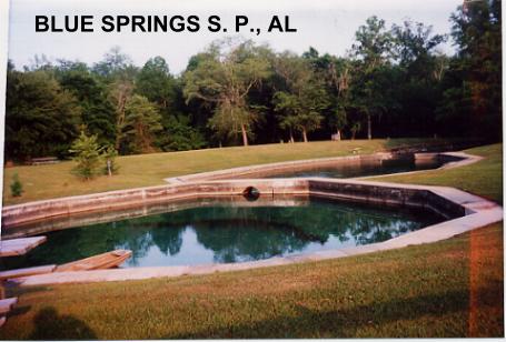
DESCRIPTION | Little River Canyon is one of the deepest gorges East
of the Mississippi. It is very beautiful but hiking trails are not yet well
developed. Much of the canyon is very hard to access. You can drive the 22
mi scenic road (RT 176) along the west rim of the canyon and, while there
are several viewpoints, the road is very high above the river and there are
few apparent points to hike down. See "directions" below for several
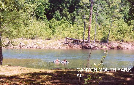
swimming places. | Here's an email we got in 8/02 "My friend and I just went to the Little River Canyon gorge in Alabama, and swam in three places named in your reviews. It was WONDERFUL!! In the southernmost one, we had 3 kids for company. In the Lower 2-Mile one, we had opportunity to skinny dip. We also had some little fish for playmates when we were just sitting on a rock, dangling our feet. What a blast! And you can swim up under the actual waterfall (once you get to it) when the water is low in summer. " NOTE: Swimming anywhere in Little River is NOT SAFE at high water levels - use caution and do not swim if water levels are high.
AREAS | Little River Canyon National Preserve (Nat'l Park Service) |
SANCTION | Unofficial |
FEE | None |
FACILITIES |
Toilets at parking area near Little River Falls and at Canyon Mouth Park. |
ACTIVITIES |
Swimming |
PHONE | None |
CAMPING | Nearby at Desoto S.P. (205)845-5075 |
BATHING SUITS | Possibly optional; some places are very isolated, see
above descriptions |
DIRECTIONS | From Gadsden, take I-59 northeast about 35 mi to Ft.
Payne. From Ft. Payne, follow RT 35 east to signs for Little River Canyon.
(See local area map for details). Some possible swimming places are (in
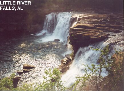
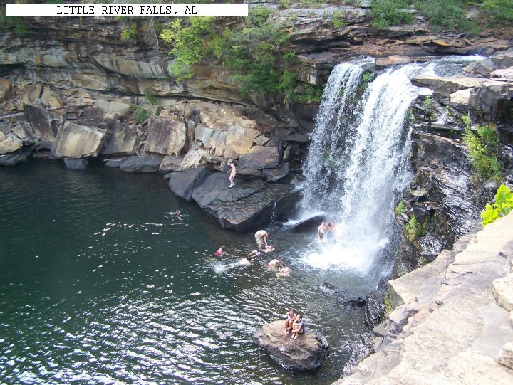
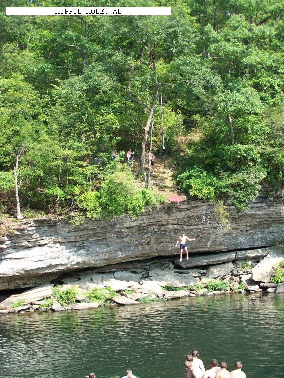
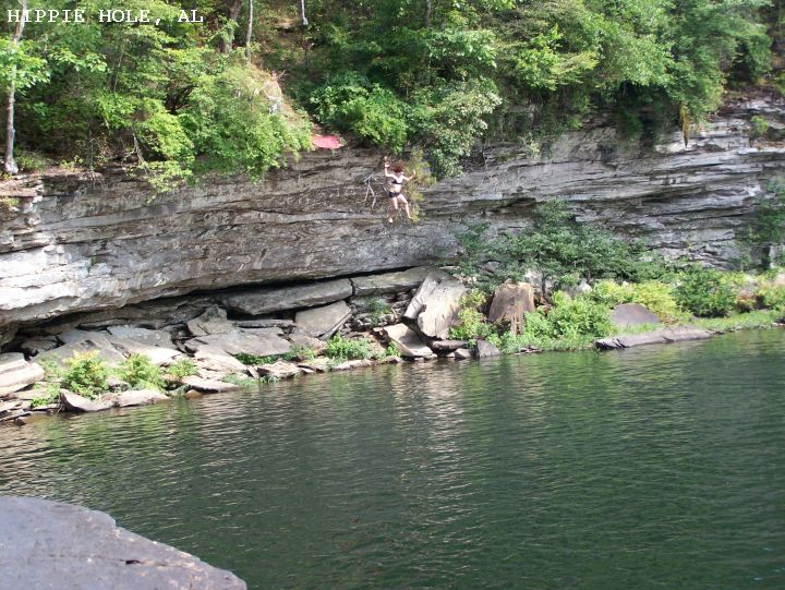
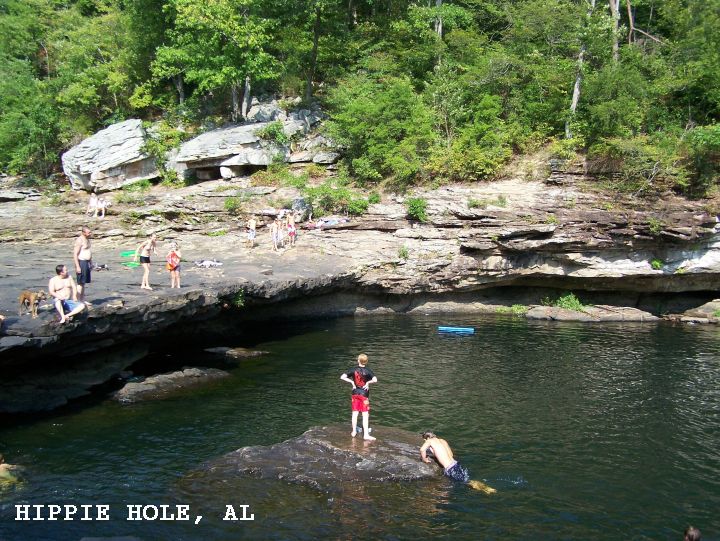
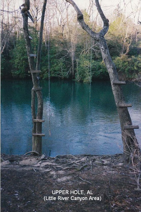
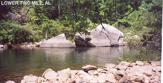
order from North to South in gorge): | LITTLE RIVER FALLS [LITF]: (See local area map) The falls are spectacular and beautiful and you can swim at the bottom WHEN WATER LEVELS ARE LOW! Park at the falls parking area off RT 35 and follow the paved walkway to a well travelled trail on the left. The trail leads to the bottom of the falls. LITTLE RIVER FALLS PHOTO , SWIMMING AT LITTLE RIVER FALLS . LAT, LON lat=34.3950, lon=-85.627(source: Topozone) (accuracy:approximate) LINK TO GOOGLE MAP. (If the kids just want to play in the water where it is not very deep and there is no hike, from the main parking lot at the falls, take the walk down to the falls and walk up the river a safe distance from falls. Alternatively, from the over flow parking lot on the other side of the road, follow signs that say "to falls" and when you get under the bridge that is the area.) Pretty confident. Not verified. Updated 1/29/2008. MARTHA'S FALLS [MART]: (See local area map) This description by a visitor:" A swimming place known by locals as the Hippie Hole. Leaving the Little River Canyon Falls parking area turn right and just up the road on the right is another gravel parking area. Park there and follow the gravel trail which will lead to a rock path that ends at the Hippie Hole. The gravel trail is approximately 1/4 mile and then the rock path down to the hole is about 200 yds... It took us about twenty minutes to get there from the car. It was a bit difficult to hike back out but the swimming was awesome. Plenty of spots to jump... " This from a visitor in 2008:"Directions were right on. The swimming is great. Plenty of people, but also plenty of space to lay out and swim. There are 3 places to jump, a 7; jump, a 12; jump and the main cliff in the photo is 20-25;.Watch the locals before jumping or swimming. High water levels are very dangerous here. The 200 yd. hill when leaving will have you panting for air. I don;t recommend this place for children under 10." PHOTO , PHOTO , PHOTO , YOUTUBE . LAT, LON lat=34.38942, lon=-85.62139(source: DeLorme) (accuracy:approximate) LINK TO GOOGLE MAP. Pretty confident. Not verified. Updated 1/29/2008. UPPER HOLE [UPPE]: (See local area map) This description by a visitor in 8/2008: "There is a spot on the other side of the road (across from Hippie Hole) with a rope swing and no difficult hills. (This is above the falls.) This spot is great for anyone that can not climb the hills. PHOTO . The directions are, leaving the main (paved) parking area from Little River Canyon Falls make a right and go for about a ; mile. Watch for a dirt road on the LEFT that cuts back to the left at a sharp angle. Take this road about 200 yds. to a small parking area at the dead end. The river is right there with the rope swing. (If you get to the big gravel parking lot on the right for Hippie Hole, you just passed it up.) When water levels are low in later summer, the river above the main falls is a great place for young children to splash and play. The river is very wide with many small shallow pools. There were many couples with young children here in Aug. 08." LAT, LON lat=34.395306, lon=-85.621186(source: DeLorme) (accuracy:approximate) LINK TO GOOGLE MAP. Very confident. Not verified. Updated 10/2008. LOWER TWO MILE [LOWE]: (See local area map) About 3.1 miles from the north end of the canyon rim parkway (RT 176), you will see a small pull out (partially hidden due to a sharp curve in the road, and easy to miss) and sign. The sign says "Lower two-mile" and gives boating advice. This is apparently a canoe put-in, although the trail, which begins at the sign, is very primitive, very steep and takes about 30 minutes to descend (and is quite a climb back up!) (There is an overlook just a short way by car further up the canyon and you can look over and see how far down you will be hiking.) Follow this trail to the river and there is a huge, deep swimming place, with a sandy beach and large rocks to sun on. You may well have this place all to yourself and bathing suits may well be optional here. LAT, LON lat=34.36397, lon=-85.65264(source: DeLorme) (accuracy:approximate) LINK TO GOOGLE MAP. LOWER TWO MILE PHOTO. Very confident. Verified. Updated 1/29/2008 EBERHART POINT [EBER]: (See local area map) A few miles from the south end of the canyon rim parkway (RT176), you will see a major pull out and sign. The sign says "Eberhart Point" and has pictures of the river below. There is a trail which begins here and goes down to the river and there are apparently swimming places there. LAT, LON lat=34.34997, lon=-85.67297(source: DeLorme) (accuracy:approximate) LINK TO GOOGLE MAP. Unknown how long or strenuous this trail is. Pretty confident. Partially verified. Updated 1/29/2008
CONFIDENCE | Pretty confident |
VERIFIED | Partially - see above |
DATE UPDATED | 1/28/2008 | |
|---|
This swimming hole listing is by www.swimmingholes.org
|
TOWNS | TUSCALOOSA, NORTHPORT | LAT LON : | lat=33.307376, lon=-87.478482
(source: Google map) (accuracy:approximate) | LINK TO GOOGLE MAP
STATE | AL |
WATER | Lake Nicol/Lake Tuscaloosa |
TYPE | Lake |
DESCRIPTION | Jumping and swimming place from bluffs alongside of
lake. | AREAS | Nicol
Park |
SANCTION | Unofficial |
FEE | None |
FACILITIES |
Unknown |
ACTIVITIES |
Swimming, Jumping |
PHONE | None |
CAMPING | None at site. |
BATHING SUITS | Unknown |
DIRECTIONS | From I-59/20 at Tuscaloosa, take Exit 73 and go north on
RT-6/McFarland Blvd for 3.9 mi (cross river) then go right on Rice Mine Rd..
Stay on Rice Mine Rd then continue onto Lake Nicol Rd. then turn right on
Old Watermelon Rd. then turn right on Nicol Park Rd.. This from a visitor:
"When you go through the park gate, the road splits and to get to the cliffs
stay to the right on;a dirt road. It ends in a cul de sac where people park
and put in kayaks, etc. There is a little walkway to a island with a picnic
table, CUTE! There is a gated service road to the west that goes up a huge
hill. Follow the road and any rocky spot along the path is good for jumping
off. The best one is about a ten minute walk around the top of the cliffs.
Hiking is treacherous but worth it if you are able."
|
CONFIDENCE | Pretty confident |
VERIFIED | No |
DATE UPDATED | 10/27/2008 | |
|---|
This swimming hole listing is by www.swimmingholes.org
|
TOWNS | MOBILE, JACKSON, ST STEPHENS | LAT, LON | lat=31.55069, lon=-88.0543(source:Map)
(accuracy:approximate) | LINK TO GOOGLE MAP
STATE | AL |
WATER | Quarry |
TYPE | Quarry |
DESCRIPTION | A clear, cool spring-fed quarry which has become a
county park (apparently used to be a State Park until funding cuts.)
WEB INFO. Has a beach and quarry swimming, also plans for a zip line and
waterslide (2013) if funding permits. Make a donation if you go. Hiking and
camping. Can be crowded with local people on warm days. |
AREAS | St. Stephens Park |
SANCTION | Official |
FEE | Donation requested |
FACILITIES |
All facilities |
ACTIVITIES |
Swimming, Other |
PHONE | (251) 246-6790 |
CAMPING | At site - mostly long-term RV campers |
BATHING SUITS | Required |
DIRECTIONS | From Mobile, take I-165 north about 5 miles then RT 43
(Jefferson Davis Hwy) about 43 miles north. Just past Wagarville, turn left
on the Mobile Cutoff Rd. and go about 3.5 miles then continue onto ST.
Stephens Ave.. Go into St. Stephens then turn right onto Howell Rd. then
right onto Cement Plant Rd. and continue about .6 miles then make a right
turn to the park. Swimming place is at a beach in the quarry. |
CONFIDENCE | Pretty confident |
VERIFIED | No |
DATE UPDATED | 1/2014 | |
|---|
This swimming hole listing is by www.swimmingholes.org
|
TOWNS | HUNTSVILLE, DECATUR, FLORENCE |
LAT LON | lat=34.28300, lon=-87.39683(source: DeLorme) (accuracy:general
area) | LINK TO GOOGLE MAP
STATE | AL |
WATER | Varies -see below |
TYPE | River/Falls |
DESCRIPTION | Several swimming places in the Sipsey River area of the
Bankhead N.F.. For details, see DIRECTIONS below. |
AREAS | Bankhead N.F., Sipsey River Wilderness |
SANCTION | Unofficial |
FEE | None |
FACILITIES |
None |
ACTIVITIES |
Swimming, Jumping, Sliding (check for safety first) |
PHONE | Unknown |
CAMPING | Unknown |
BATHING SUITS | Unknown |
DIRECTIONS | From Decatur, go southwest on RT 24 to RT 33. Go south
on RT 33 into the Bankhead N.F.. At CR6 (or CR60)(Cranal Rd.?), turn west
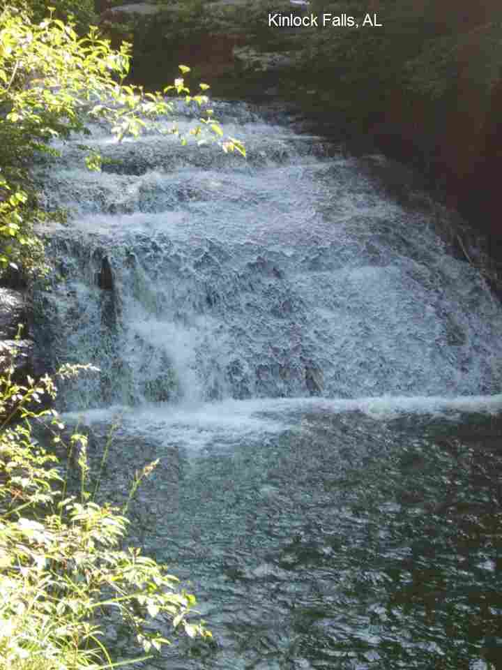
(right) and continue to the Sipsey Recreation Area then: | SIPSEY RIVER [SIPR]: The Sipsey River is Alabama's only Wild and Scenic River. It has numerous popular swimming holes in the Sipsey Wilderness Area. Places to jump from large boulders into river. Jumping (check for safety first). To get here: At the Sipsey Recreation Area (above) turn left into a parking area with an iron bridge over the Sipsey River. The swimming places are here. LAT LON lat=34.28300, lon=-87.39683(source: DeLorme) (accuracy:approximate) LINK TO GOOGLE MAP> Pretty confident. Not verified. Updated 1/2008. KINLOCK FALLS [KINL]: Swimming places and sliding possibilities at multi-level, cascade-type waterfall. Picnic area also. WEB INFO , PHOTO , MORE WEB INFO. CAUTION: There are hidden deep places here and swift currents, be very careful with children here - lifejackets recommended. There have also been reports of trash here. To get here: From the Sipsey Recreation Area (above), continue west on CR 6 to the end of this road then turn north (right) and drive past where the pavement ends. When you come to a sharp curve to the left, you will soon pass on the right a gravel road then see several small pull offs to park (if you get to the bridge you have passed it). Park and walk down a short, steep path to the falls. LAT LON lat=34.3086, lon=-87.5017(source: Topozone) (accuracy:exact) LINK TO GOOGLE MAP. Pretty confident. Not verified. Updated 1/2008.
CONFIDENCE | Pretty confident |
VERIFIED | no |
DATE UPDATED | 1/28/2008 | |
|---|
This swimming hole listing is by www.swimmingholes.org
|
TOWNS | BIRMINGHAM, PINSON | LAT, LON | lat=33.70224, lon=-86.69646(source:Map)
(accuracy:approximate) | LINK TO GOOGLE MAP
STATE | AL |
WATER | Turkey Creek |
TYPE | Creek/Falls |
DESCRIPTION | Small, sliding falls with swimming hole at the bottom.
Current can be strong - children who slide down the falls may need a life
jacket and/or someone to catch them at the bottom.
WEB INFO ,
MORE INFO.
CAUTION: The rocks in the creek are extremely slippery. Walk on all fours
(hands and feet) if you feel you may slip. |
AREAS | Turkey Creek Nature Preserve |
SANCTION | Unofficial |
FEE | Unknown |
FACILITIES |
None |
ACTIVITIES |
Swimming, Sliding |
PHONE | (205)680-4116 |
CAMPING | No camping at site |
BATHING SUITS | Customary |
DIRECTIONS | From Birmingham, take I-20 E to the Tallapoosa St (Exit
No. 128). Go north on Tallapoosa St a short way then merge onto RT 79
(Vanderbilt Rd) going north. Continue for approximately 12 miles (becomes
Pinson Valley Pkwy) then turn left onto Narrows Road (in Pinson area) then
right onto Turkey Creek Road. Turkey Creek Rd. goes through the nature
preserve and follow Turkey Creek Rd.. You may see places you want to stop
or, if you continue less than 1 mile on this road, you will come to the
sliding falls.
CAUTION: The rocks in the creek are extremely slippery. Walk on all fours
(hands and feet) if you feel you may slip. |
CONFIDENCE | Pretty confident |
VERIFIED | No |
DATE UPDATED | 2/2014 | |
|---|
This swimming hole listing is by www.swimmingholes.org
|
|
|---|
This swimming hole listing is by www.swimmingholes.org
|
TOWNS | MONTGOMERY, WETUMPKA (TN) |
STATE | AL |
WATER | Coosa and Tallapoosa Rivers |
TYPE | River/Falls |
DESCRIPTION | Several rivers join in the Wetumpka area (northeast of
Montgomery) with unofficial wading/swimming opportunities in 2 State parks.
For details, see DIRECTIONS below. |
AREAS | Fort Toulouse/Jackson and Corn Creek State Parks |
SANCTION | Unofficial |
FEE | Unknown |
FACILITIES |
Full facilities at the Fort Toulouse/Jackson State Park |
ACTIVITIES |
Swimming, Water play |
PHONE | (334) 567-3002 (Fort Toulouse/Jackson State Park) |
CAMPING | At Fort Toulouse/Jackson S. P. |
BATHING SUITS | Required |
DIRECTIONS | From Montgomery, take RT 9 north about 15 miles (several
turns required to stay on RT 9) toward Wetumpka. Then: | FORT TOULOUSE/JACKSON PARK [FTJP]: Fort Toulouse/Jackson Park has river access and, at the very west end of the park after a long walk, there is unofficial swimming access where the Coosa and Tallapoosa rivers meet to form the headwaters of the Alabama River. A sacred place for the Indians who use to reside there. PARK WEB SITE. To get here from RT 9, about 15 miles north of Montgomery, look for the Key West Inn on the left and Super Walmart on the right, then a shopping center on the right. At the shopping center there is a red light; turn left here onto Fort Toulouse Road, and go approximately 2.5 miles; Fort Toulouse/Jackson Park is at the very end of the road. Once in the park, walk to the far west end of the park where three rivers come together. The swimming hole is here. Address: 2521 West Ft Toulouse Rd, Wetumpka, Alabama 36093 LAT LON: lat=32.50366, lon=-86.26218(source: Map) (accuracy: approximate) LINK TO GOOGLE MAP. Pretty confident. Not verified. Updated 2/2014. CORN CREEK PARK [CORP]: Corn creek is a large creek with small rapids and rock falls. Average depth is 1-3 feet. Jumping and rope swing. The creek empties into a larger river. PARK WEB SITE , ARTICLE/PHOTOS ABOUT WATER PLAY. To get here from RT 9, about 15 miles north of Montgomery, go past Watumpka, cross RT 14, keep left on RT 231 where RT 9 goes off to the right, then (about 1 mile past RT 14) across from the prison, turn left on a gravel road and go 1 mile more through woods into the park. LAT LON: lat=32.5598553 lon=-86.20246(source: Web site) (accuracy: approximate) LINK TO GOOGLE MAP. Pretty confident. Not verified. Updated 2/2014.
CONFIDENCE | Pretty confident |
VERIFIED | No |
DATE UPDATED | 2/2014 | |
|---|
HOME