See a SLIDESHOW of swimming hole photos in this state.
This swimming hole listing is by
www.swimmingholes.org
BEAR CREEK AREA
[2 PLACES]
(BEAR)
|
|
TOWNS | SYLVA, CULLOWEE, CASHIERS |
| LAT, LON | lat=35.2444, lon=-83.0153(source: DeLorme) (accuracy:general area)
LINK TO GOOGLE MAP |
|
STATE | NC | |
WATER | Bear Creek Lake, Wolf Creek Lake | |
TYPE | Falls, Creek, Lake | |
DESCRIPTION | Several swimming holes in lakes along RT 281 southeast of Sylva and Cullowhee. For details, see DIRECTIONS below.
| |
AREAS | Nantahala N. F. | |
SANCTION | Unofficial | |
FEE | None | |
FACILITIES |
Unknown | |
ACTIVITIES |
Swimming | |
PHONE | Unknown | |
CAMPING | Developed camping unknown. Primitive camping is allowed in the National Forest. | |
BATHING SUITS | Optional at most places, very remote | |
DIRECTIONS | From Asheville, go west on I-40 about 25 miles to the Waynesville area then take RT 23/74 southwest about 25 miles to Sylva. From Sylva, take RT 107 southeast about 12 miles to Tuckasegee then turn east (left) on RT 281 and then:
BEAR CREEK LAKE [BEAC]: Go about 6 miles on RT 281 until you come to a sign on the right saying Bear Lake N.C. Boat Launch. Follow road down and park at parking area and walk down road to right, this will take you down to a sandy beach. Secluded - can be regarded as clothing optional in places. LAT, LON lat=35.24361, lon=-83.06419(source: DeLorme) (accuracy: approximate) LINK TO GOOGLE MAP Pretty confident. Not verified. Updated 6/23/2003.
WOLF CREEK LAKE [WOLF]: Continue on RT 281 about 12 miles to Wolf Creek Baptist Church on the right. A short way past the church, on RT 281, is Wolf Creek Lake. Take Wolf Lake Cemetery road on the left (this may be an error - it may really be Jess Owens Rd. on the left - pls tell us if you find out) until you see red painted trees on the left. Get out and look over the edge. There's a path leading down to a beach section, can be regarded as clothing optional. LAT, LON : lat=35.22733, lon=-82.99833(source: DeLorme) (accuracy: general area) LINK TO GOOGLE MAP. Pretty confident. Not verified. Updated 6/23/2003.
| |
CONFIDENCE | Pretty confident | |
VERIFIED | No | |
DATE UPDATED | 6/23/2003 |
|
This swimming hole listing is by
www.swimmingholes.org
BIG CREEK AREA
[5 PLACES]
(BIGC)
|
|
TOWNS | KNOXVILLE, ASHEVILLE, WATERVILLE | |
STATE | NC | |
WATER | Big Creek, Mouse Creek | |
TYPE | Falls, Creek | |
DESCRIPTION | Several swimming holes near the NE border of the Great Smoky Mtns N. P. in the Big Creek Recreation Area on the TN-NC border. NOTE: The National Park Service will not allow you to take your dog on this trail. For more on this, see Pets in National Parks . See DIRECTIONS below for details.
| |
AREAS | Great Smoky Mtn. N. P. | |
SANCTION | Unofficial | |
FEE | None | |
FACILITIES |
Picnic Tables, toilets | |
ACTIVITIES |
Swimming | |
PHONE | Unknown | |
CAMPING | Big Creek Campground is at the site. It is a short distance walk-in to the sites, tents only. | |
BATHING SUITS | Optional at most places, very remote | |
DIRECTIONS | From Asheville, go west on I-40 to exit 451, the Waterville exit. Turn south across the Pidgeon River and follow the paved road past Carolina Power and Light into Great Smoky Mtn. N.P.. Go straight through the intersection onto gravel a road, pass the ranger station on right, go to hiking/picnic area and park in parking area. Then:
BIG CREEK [BIGK]: There is a swimming hole right in the Big Creek Recreation Area picnic area just below a small metal bridge. A great play place, very easy to reach. LAT, LON : lat=35.75011, lon=-83.11031(source: DeLorme) (accuracy: approximate) LINK TO GOOGLE MAP Very confident. Verified 4/01
UNNAMED HOLE [UNNA]: The Big Creek trail begins a short distance up the road from the parking area on the left. The trail is signed for Walnut Bottoms as the destination. Hike on this rustic road. At about 1.0 miles (25 minutes walking) there is a path off to the left marked by a rocky path that leads down to a good swimming hole below a small falls. LAT, LON lat=35.73681, lon=-83.12892(source: DeLorme) (accuracy: approximate) LINK TO GOOGLE MAP Very confident. Verified 4/01.
MIDNIGHT HOLE [MIDN]: Continue on this trail and at about 1.5 miles from the beginning (40 minutes walking) there are tumbled down stone steps on an apparent path on the left that go to Midnight Hole. Here a small falls drops into a spectacular swimming hole. A super jacuzzi-like swimming hole at bottom of double falls. PHOTO , PHOTO . LAT, LON : lat=35.737, lon= -83.129 (source: Topozone-p ) (accuracy: exact) LINK TO GOOGLE MAP Very confident. Verified 4/01. Updated 10/29/04.
MOUSE CREEK FALLS [MOUS]: Continue up this trail to 2.0 miles from the beginning and you will hear these falls (not see them usually) (there is a horse hitching rail here) and a short path leads you to the falls, which are in Mouse Creek where it goes into Big Creek. Swim at bottom of falls. Not verified.
LINK TO PHOTO BY WATERFALL WALKS. LAT, LON : lat=35.73417, lon= -83.13389 (source: Topozone ) (accuracy: exact) LINK TO GOOGLE MAP.
POOL ON BIG CREEK [POOL]: Continue up this trail to 2.5 miles from the beginning to a board crossing a big pool the Big Creek. Cross the board and go left down a path to a big rock where you can swim. AT, LON lat=35.73773, lon=-83.14298(source: DeLorme) (accuracy: approximate) LINK TO GOOGLE MAP Not verified.
| |
CONFIDENCE | Very confident | |
VERIFIED | Mostly - in 4/01 | |
DATE UPDATED | 4/19/2001 |
|
This swimming hole listing is by
www.swimmingholes.org
BIG LAUREL CREEK AREA
[3 PLACES]
(BIGA)
|
|
TOWNS | ASHEVILLE, JOHNSON CITY (TN), HOT SPRINGS | |
LAT, LON | lat=35.9011, lon= -82.7703(source: DeLorme-p) (accuracy: general area)
LINK TO GOOGLE MAP | | STATE | NC | |
WATER | Big Laurel Creek | |
TYPE | Creek | |
DESCRIPTION | An easy, family-type, hike to several swimming holes of various degrees of challenge in Big Laurel Creek on its way to join the French Broad River. For details, see DIRECTIONS below. | |
AREAS | Pisgah N. F. | |
SANCTION | unofficial | |
FEE | None | |
FACILITIES |
None | |
ACTIVITIES |
Swimming, rope swing | |
PHONE | None | |
CAMPING | East of here at Carolina Hemlock (also a great family swimming hole) | |
BATHING SUITS | May be optional at more remote places | |
DIRECTIONS | From Asheville, go north on US 19 (freeway) to Weaverville then take RT 25 north about 20 miles. As you approach the intersection of RT 25 and RT 208, you will see on the right a gravel road signed for a recycling facility and then also on the right a 25 MPH curve speed sign. On the left hand side of the road, right across from this curve sign, is an unsigned non-descript gravel road that looks like a driveway - turn left into this road and park where it says "foot traffic only". (It also says that this is a private road, but it is not, although there is some private land along side of it in the beginning before you get into the National Forest land - so keep off the private land.)
Walk down this road and keep left at the intersection. You will then be walking downstream along Big Laurel Creek on an old, abandoned road, that gets narrower as you go down the gentle grade. There are swimming places in this pretty creek at about 1 mile, 1.5 miles and 2.5 miles (and maybe others) from where you parked. CAUTIONOne or more of these swimming places are unsafe at higher water levels - study each one carefully for currents before swimming.
| |
CONFIDENCE | Pretty confident | |
VERIFIED | Partially, 8/07 | |
DATE UPDATED | 8/23/2007 |
|
This swimming hole listing is by
www.swimmingholes.org
BIG LAUREL FALLS
(BIGL)
|
|
TOWNS | CASHIERS, FRANKLIN | |
LAT, LON | lat=35.0273, lon= -83.4920(source: DeLorme) (accuracy: general area)
LINK TO GOOGLE MAP | | STATE | NC | |
WATER | Unknown | |
TYPE | Falls. | |
DESCRIPTION | Swimming hole in pool at bottom of
falls. | |
AREAS | Nantahala N.F., Nantahala Wilderness Area | |
SANCTION | Unknown | |
FEE | None | |
FACILITIES |
Unknown | |
ACTIVITIES |
Swimming | |
PHONE | Unknown | |
CAMPING | Unknown | |
BATHING SUITS | Unknown | |
DIRECTIONS | From Franklin (about 20 mi west of Cashiers on RT 64) go west on RT 64
about 12 miles then turn south (left) on old highway 64 (may be SR 1448 or Old Murphy Rd.). Go about 2 miles then go right on FR67 then about 7 miles more to parking area signed for Big Laurel Falls. Take the trail about .5 mile
to the falls-go right at each fork in the trail. | |
CONFIDENCE | Pretty confident | |
VERIFIED | No | |
DATE UPDATED | 1/13/2000 |
|
This swimming hole listing is by
www.swimmingholes.org
BOONE AREA
[4 PLACES]
(BOON)
|
|
TOWNS | BOONE, BLOWING ROCK, SUGAR GROVE |
|
STATE | NC | |
WATER | Varies - see below | |
TYPE | Varies - see below | |
DESCRIPTION | Several swimming holes in creeks and falls in the Watoga River area west and south of Boone. For details, see DIRECTIONS below.
| |
AREAS | Pisgah N. F.., Julian Price Park | |
SANCTION | Unofficial | |
FEE | None | |
FACILITIES |
None | |
ACTIVITIES |
Swimming, jumping | |
PHONE | Unknown | |
CAMPING | At Julian Price Memorial Park, just south of "Hebron Rock" swimming hole (see below). | |
BATHING SUITS | Unknown | |
DIRECTIONS | From Boone:
WINKLERS CREEK [WINK]: Large, popular swimming hole, very close to Boone, with rope swing. To get here from downtown Boone, take RT 221 south, turn left where RT 221 goes left, then very shortly turn south (right) on Winklers Creek Rd.. Go about 1 mile (turning right to stay on Winklers Creek Rd.). Just before you come to Rocky Creek Rd. on the left, there is a small parking pull - out on the right side of Winklers Creek Rd.. (Look for cars parked here on warm days). Park here and walk (carefully) across the road then take a short path down to the creek and the swimming hole. LAT, LON lat=36.19591,, lon=-81.6773(source: map) (accuracy: approximate) LINK TO GOOGLE MAP Pretty confident. Not verified. Updated 12/2013.
TRASH CAN FALLS [TRAS]: Popular swimming and jumping places at a falls into a small, rocky gorge with a water slide as well. YOUTUBE VIDEO . PHOTOS AND INFO . To get here from Boone, take RT 421/321 northwest. Where RT 421 goes off to the north, keep left on RT 321. Go through Sugar Grove and, just after you cross the Watoga River on a concrete bridge, park at a small dirt pull out on the north (right) side of the road. Go across RT 321 and take the small trail to the jumping spot at the falls. LAT, LON lat=36.25224, lon=-81.83418(source: DeLorme) (accuracy: approximate) LINK TO GOOGLE MAP Pretty confident. Not verified. Updated 4/1/2008.
SNAKE PIT [SNAK]: Big, sunny swimming hole with flat rocks and jumps - very near Trash Can Falls. . PHOTOS AND INFO . Just go a bit more northwest on RT 321 to where there is a long guardrail. Park and take the trail that goes down steeply behind the east end of the guardrail to the swimming hole. LAT, LON lat=36.2533, lon=-81.8362(source: DeLorme) (accuracy: approximate) LINK TO GOOGLE MAP Pretty confident. Not verified. Updated 4/1/2008.
NEW HOLE [NEWH]: Mostly a put-in place for New River tubing and canoeing, it is quite deep and a good swimming place as well. PHOTOS AND INFO . From downtown Boone, take E. King St east then turn north (left) on Jefferson Rd (RT 194) and go about 3 miles then turn east (right) on Castle Ford Rd.. Go about 4.5 more miles on Castle Ford Rd then cross the South Fork New River on Castle Ford Rd and turn immediately left on River Rd. The put-in and swimming place is right here. LAT, LON lat=36.270945, lon=-81.591564(source: Web Site) (accuracy: approximate) LINK TO GOOGLE MAP Pretty confident. Not verified. Updated 12/2013.
HEBRON ROCK [HEBR]: About a 3 mile round-trip hike to big boulders, small falls and little swimming holes in a gorge. . PHOTOS AND INFO . From the picnic area at Julian Price Memorial Park (on the Blue Ridge Parkway), take the Boonefork Trail, which is a loop that begins and ends at the park. Take the right-hand loop, through the old lake bed, and into the woods. Hike to just before the (signed) 1.5 mile marker where you will see two trees with red flags around them. This indicates a spur trail to the river. The swimming holes is here. LAT, LON (of picnic area) lat=36.13978 lon=-81.73575(source: Map) (accuracy: approximate) LINK TO GOOGLE MAP Pretty confident. Not verified. Updated 12/2013.
| |
CONFIDENCE | Pretty confident | |
VERIFIED | No | |
DATE UPDATED | 8/2013 |
|
This swimming hole listing is by
www.swimmingholes.org
BULLHOLE
(BULL)
|
|
TOWNS | WINSTON-SALEM, STATESVILLE, COOLEEMEE
| |
LAT, LON | lat=35.80729, lon= -80.5634(source: map) (accuracy: approximate)
LINK TO GOOGLE MAP | |
STATE | NC | |
WATER | South Fork Yadkin River | |
TYPE | River | |
DESCRIPTION | Swimming hole in a park at bottom of dam, pretty dependable water flow released by dam. Very large rocks, some flat to sunbathe on, some to slide down. Canoe launch, picnicking and restrooms. This is an old dam, formerly used by a textile mill, now used by the power company to generate electricity. The flow level is sometimes low (as in some of our photos), when the power company diverts more water into their turbines. Now a park, it is well signed and easy to find. SNAKE ALERT. | |
AREAS | River Park at Cooleemee Falls | |
SANCTION | Unofficial | |
FEE | None | |
FACILITIES |
Restrooms, Picnic Tables, Canoe Launch | |
ACTIVITIES |
Swimming, wading, sliding | |
PHONE | Unknown | |
CAMPING | None at site | |
BATHING SUITS | Required | |
DIRECTIONS | From Winston-Salem, take I-40 southwest to RT 601 southeast to RT 801 southwest to the town of Cooleemee. At Cooleemee, continue south on RT 801, cross the bridge over the South Yadkin River, then take the first right on Needmore Rd.. Take the next right (at the church) onto Erwin Temple Church Rd.. Follow signs to park. | |
CONFIDENCE | Very confident | |
VERIFIED | Yes, 5/02 | |
DATE UPDATED | 12/2013 |
|
This swimming hole listing is by
www.swimmingholes.org
CASHIERS AREA
[5 PLACES]
(CASH)
|
|
TOWNS | ASHEVILLE, BREVARD, CASHIERS, HIGHLANDS, FRANKLIN
| | STATE | NC | |
WATER | Varies, see below | |
TYPE | Varies, see below | |
DESCRIPTION | Several swimming holes at waterfalls in the general Cashiers area. For details, see DIRECTIONS below. |
| |
AREAS | Unknown | |
SANCTION | Unknown | |
FEE | unknown | |
FACILITIES |
Unknown | |
ACTIVITIES |
Sliding | |
PHONE | Unknown | |
CAMPING | Nearest known camping is near Brevard in Pisgah N.F.,
several camping areas there, Davidson River is nicest. | |
BATHING SUITS | Unknown | |
DIRECTIONS | From Brevard, go about 28 mi southwest on RT 64 to Cashiers. Then:
CASHIERS SLIDING ROCK [CASS]:A gentle, natural waterslide, and a swimming hole with sandy beach; appropriate for children. Also called "Little Sliding Rock". PHOTO , PHOTO , PHOTO , YOU TUBE VIDEO OF SLIDING ROCK. To get here from RT 64 in Cashiers: From the intersection of RT 107 and RT 64 in Cashiers, follow RT 107 south for a mile or so to Whitesides Cove Road. Look for the golf course hole on the right to be sure you are at the correct spot. Turn right onto Whitesides Cove Road and follow it downhill to the bridge over the Chattooga River. Park along the road at the bridge (don't block the driveway) or drive up the hill to a pull off on the right. Follow one of the numerous paths upstream to the sliding rock and pool. (There are also some swimming places further upstream: YOU TUBE VIDEO - UPSTREAM OF SLIDING ROCK . Very confident. Verified 10/02. Updated 12/09. LAT, LON : lat=35.07538, lon= -83.10876(source: measured) (accuracy:exact)
LINK TO GOOGLE MAP. |
|
SILVER RUN FALLS [SILV]: A 40 foot falls pours into a pool of cold water, local swimming place- sandy beach and pretty pool. PHOTO , LINK TO VIDEO . To get here: Continue on RT 107 south, (past the turnoff for Cashiers Sliding Rock) just under 4 miles from RT 64, park at a graveled pull-off on the left with guardrails and a utility pole. There is a trail marker just behind the guardrail. Take this short trail to the falls. Very exposed location - bathing suits appropriate. Very confident. Verified 10/02. LAT, LON : lat=35.06611, lon= -83.06562 (source: measured) (accuracy:exact)
LINK TO GOOGLE MAP.
ELLICOTT ROCK [ELLI]: Swim in creek on way to historic survey marker (Ellicott Rock) that was supposed to mark the junction of SC, NC and GA but was in a bit in error and is now in NC. To get here: Continue on RT 107 south for a total of 6.9 miles from RT 64 and turn right (west) onto Bull Pen Rd.(RT 1100) into the Ellicott Rock Wilderness area. Approximately at the bridge where this road crosses Fowler Creek, park at the trailhead for Trail # 431 (Bad Creek Trail). One can swim in the creek (Fowler Creek, I think) somewhere along in here, either at the bridge or along the trail to Ellicott Rock. The hike is about 3.5 miles each way. To get to the trail and the rock: The trail begins going upgrade on an old logging road then over a ridge and becomes a footpath going down steeply to a gorge and river (Chattooga River I think). (It is a tough climb back up this trail!) (DO NOT FALL IN THE RIVER ON THIS STEEP DOWNGRADE, APPARENTLY MANY HAVE.) Pretty confident. Partially verified 10/02 (found Bull Pen Rd, did not go further.) .(There is a geocache here; see THE GEOCACHING WEB SITE .) Here are the coordinates of the geocache, which is near the rock: LAT, LON : lat=35.002277, lon= -83.109055(source: Geocaching web site) (accuracy: general area for swimming hole)
LINK TO GOOGLE MAP.
UPPER CULLASAJA FALLS[UPPC]: Swimming hole in pool at bottom of Upper Cullasaja Falls in the Cullasaja River, also known as "Quarry Falls". LINK TO PHOTO . There are several other falls in the immediate area - in the Nantahala N.F.. TO get here: From Cashiers, go west on RT 64. At about 6.6 miles past Highlands see a large paved pull out on the south (left) side of road. Walk to the falls. Very confident. Not verified. Updated 1/14/2004. LAT, LON lat=35.11675, lon=-83.27067(source: DeLorme) (accuracy:exact)
LINK TO GOOGLE MAP.
SCHOOLHOUSE FALLS [SCHO]: This from a visitor:" The huge swimming hole here is great, with a sandy beach and soft sand on the floor of the pool. However, the water is just plain kickass COLD! Some of the coldest water outside the Smokies that I've gone swimming in. Pretty deep, too--probably eight to nine feet deep. Neat thing about that waterfall is that you can walk behind it. The water was so cold, however, that I could only swim in it for about twenty minutes--and this was in the middle of summer. I don't know why it was so cold." PHOTO 1 , PHOTO 2 . To get here from Cashiers, drive east 2 miles on RT 64 to Cedar Creek Road on the left. Drive up Cedar Creek Road 2 miles to its intersection with Breedlove Road. Continue on Breedlove approximately 4 miles to its end and the parking area for Panthertown. LINK TO HIKING INFO .
From GORP site: "Hike down from the parking area and continue on a gravel road to an intersection of three roads (approximately one mile from the parking area). For Granny Burrell Falls on Panthertown Creek, go right .2 miles and cross an old wood bridge. The trail for the falls is on the right. For Schoolhouse Falls, take the center trail .9 miles to a small shelter on the Tuckasegee River. Cross the old wood bridge on the right and continue along Greenland Creek. The access trails to Schoolhouse Falls are on either side of a second wood bridge. If the first trail is taken, watch for a narrow trail on the right which goes up Little Green. The trail on top of Little Green is on the rock outcropping. Please avoid walking on the mosses and lichens; they are fragile and take years to grow back. The trail turns into the woods and goes steeply down to another road. Turn right and hike through a pine forest in the valley floor. The spur trail to Granny Burrell Falls will be on the left. The climb out of the valley is steep."
LAT, LON lat=35.16310, lon=-83.00667(source: DeLorme) (accuracy:exact)
LINK TO GOOGLE MAP. Very confident. Not verified. Updated 1/4/2007.
| |
CONFIDENCE | See above | |
VERIFIED | Some; see above | |
DATE UPDATED | 1/5/2007 |
|
This swimming hole listing is by
www.swimmingholes.org
DEEP CREEK AREA
[2 PLACES
(DEEP)
|
|
TOWNS | ASHEVILLE, BRYSON CITY | |
STATE | NC | |
WATER | Deep Creek | |
TYPE | Creek | |
DESCRIPTION | Beautiful mountain creek with cool (cold?) crystal clear mountain
water perfect for tubing and swimming.
DEEP CREEK[DEEC]: At the end of the group campground, there is a deep place in Deep Creek under the bridge for swimming. Also, if you walk up the creek from here, there is swimming at the foot of Tom's Branch Falls on the left just after you cross the second bridge over the creek. Also there appears to be swimming further up where Indian Creek comes into Deep Creek. LAT, LON : lat=35.46911, lon= -83.42944(source: DeLorme) (accuracy: general area) LINK TO GOOGLE MAP.
Tubing begins at the junction of Indian Creek and Deep Creek. The upper section is steep, with a number of drops which are challenging and exciting for tubers (though probably not safe for very small children). A great family recreational outing. Companies rent tubes (around $4-5) on the road in. Rent one with a seat - it's worth the extra $1 or so!
INDIAN CREEK FALLS[INDI]: INDIAN CREEK FALLS: From the merge of Deep Creek and Indian Creek, walk up Indian Creek to Indian Creek Falls where there is a large inviting pool at the bottom. LAT, LON lat=35.4722, lon=-83.4258(source: DeLorme-p) (accuracy: exact) LINK TO GOOGLE MAP.
| |
AREAS | Great Smoky Mountains Nat'l Park | |
SANCTION | Official | |
FEE | No | |
FACILITIES |
Toilet,
Picnic tables | |
ACTIVITIES |
Swimming,
Tubing | |
PHONE | unknown | |
CAMPING | At the site is Deep Creek campsite in Great Smoky Mtn. N. P., operated
by park service. Also, numerous commercial campgrounds in the immediate
vicinity. | |
BATHING SUITS | Customary | |
DIRECTIONS | From the southern end of the Blue Ridge Parkway, take RT 441 southeast then RT 19 southwest to Bryson City. Follow signs in Bryson City to Deep Creek. | |
CONFIDENCE | Very Confident | |
VERIFIED | Yes | |
DATE UPDATED | 1/3/2001 |
|
This swimming hole listing is by
www.swimmingholes.org
DUPONT S. F. AREA
[6 PLACES]
(DUSF)
|
|
TOWNS | ASHEVILLE, BREVARD, HENDERSONVILLE, PENROSE | | STATE | NC | |
WATER | Little River | |
TYPE | Falls | |
DESCRIPTION | Swimming holes in pools at bottom of several falls. DO NOT CLIMB UP OR DOWN THE FALLS - DO NOT SWIM AT THE TOP OF THE FALLS - VERY UNSAFE!
| |
AREAS | DuPont State Forest | |
SANCTION | Unofficial | |
FEE | None | |
FACILITIES |
Restrooms are in the Hooker Falls parking area | |
ACTIVITIES |
Swimming | |
PHONE | Unknown | |
CAMPING | None at site | |
BATHING SUITS | Customary; lots of people around | | DIRECTIONS | From Hendersonville, take I-26 to exit 49B for RT 64 west towards Hendersonville. Go 2.4 miles on RT 64 to North Church Street/Business RT 25 south. Turn left onto Church Street and go 0.6 miles south. Turn right onto Kanuga Road and go 11 miles (note that Kanuga Rd becomes Crab Creek Rd). Turn left onto DuPont Road then:
HOOKER FALLS ACCESS [HOOK]: Five falls accessible from this parking area. To get here, go 4.2 miles on DuPont Rd. (above) keeping right (note that DuPont Rd becomes Staton Road). Find the Hooker Falls parking lot on the right just before the Little River bridge. LAT, LON (Hooker Falls Access parking) lat=35.20236 lon=-82.61890(source: Map) (accuracy: approximate) LINK TO GOOGLE MAP.
For Triple Falls, High Falls, Grassy Creek Falls, and Bridal Veil Falls (all have swimming/wading possibilities): It is about a 3.5 mile round trip hike that encompasses all 4 falls. From the south side of the same parking area above, take the stairs up to Staton Rd. and cross the road carefully. Then follow the directions here WEB DIRECTIONS/PHOTOS to all 4 falls. Pretty confident. Not verified. Update 12/2013.
For Hooker Falls (a fabulous and popular swimming hole): From the parking area above, walk around the gate in the parking lot and along the dirt road. Then follow the directions here WEB DIRECTIONS/PHOTOS to Hooker Falls. Pretty confident. Not verified. Update 12/2013.
GUION FARM ACCESS [GUIN]:From Crab Creek Redland DuPont Rd. (above) go a short way on DuPont Rd. then turn left onto Sky Valley Rd.. Go about 1.3 miles on Sky Valley Rd. to the Guion Farm Access point. LAT, LON (of Guion Farm Access parking) lat=35.21485 lon=-82.5877(source: Map) (accuracy: approximate) LINK TO GOOGLE MAP. For Wintergreen Falls (swimming/wading possibilities) it is a 3 mile round trip hike. Follow the directions here WEB DIRECTIONS/PHOTOS to Wintergreen Falls. Pretty confident. Not verified. Update 12/2013.
| |
CONFIDENCE | Pretty confident | |
VERIFIED | No | |
DATE UPDATED | 12/2013 |
|
This swimming hole listing is by
www.swimmingholes.org
ELK RIVER FALLS
(ELKR)
|
|
TOWNS | ASHEVILLE, JOHNSON CITY (TN), BOONE, ELK PARK,
| |
LAT, LON | lat=36.20356, lon= -81.97337(source: map) (accuracy:approximate)
LINK TO GOOGLE MAP | |
STATE | NC | |
WATER | Elk River | |
TYPE | Waterfall | |
DESCRIPTION | Thunderous 75' falls, rhododendron grove, swim in huge,
deep pool at bottom. (Also be known as Big Falls) Water somewhat murky at times. Easy entrance to pool over rocks.
Don't attempt to jump off falls, several have died jumping here. | |
AREAS | Pisgah N.F. | |
SANCTION | Unofficial | |
FEE | No | |
FACILITIES |
Picnic Tables | |
ACTIVITIES |
Swimming | |
PHONE | None | |
CAMPING | Several camping places nearby; Julian Price area in the
Blue Ridge Parkway N.P., Boone Fork area in the Pisgah N.F. near
the town of Lenoir, several campgrounds in the W. Scott Reservoir
Corps of Engineers area. Also some camping in Cherokee N.F., north on Rt
19E. | |
BATHING SUITS | Unknown | |
DIRECTIONS | From the Blue Ridge Parkway at Linville Falls, milepost (approx) 315, take RT 221 to the north. At the junction with RT 194, go left (northwest) through Newland to RT 19E then a short distance northwest on 19E to town of Elk Park (just before the TN border). From Elk Park, turn right off 19E then immediately left onto Old Mill Rd., the main street in town. Go about .4 mi on Old Mill Rd. then right on Elk River Road for 4.1 mi (last 1.8 mi is gravel) to the N.F. picnic area at the end of this road. Short path (marked) leads to falls.
| |
CONFIDENCE | Very confident | |
VERIFIED | yes | |
DATE UPDATED | 6/30/1999 |
|
This swimming hole listing is by
www.swimmingholes.org
ELK SHOALS
(ELKS)
|
|
TOWNS | ASHEVILLE, BOONE, JEFFERSON, GLENDALE SPRINGS | |
LAT, LON | lat=36.36647, lon= -81.43188(source: DeLorme) (accuracy: approximate)
LINK TO GOOGLE MAP | |
STATE | NC | |
WATER | South Fork New River | |
TYPE | River | |
DESCRIPTION | Swimming place in the South Fork New River at Elk Shoals United Methodist Camp. The swimming hole is mainly for people staying there but if you contact them (phone and email below) ahead of time and get a (free) permit you can swim as a day visitor. Do not just show up and expect day use of the swimming hole. Management also asks that you help keep the area CLEAN for the next group. The beach is located on a gravel road, as soon as you reach the paved road, you are in the "private part of the campground" for persons staying there only.
LINK TO ELK SHOALS CAMP WEB PAGE | |
AREAS | Elk Shoals United Methodist Camp | |
SANCTION | Official | |
FEE | Not for swimming (but get free permit ahead of time) | |
FACILITIES |
Unknown | |
ACTIVITIES |
Swimming, tubing | |
PHONE | (336) 877-4607 Email: elkshoals@skybest.com | |
CAMPING | At site for camp attendees. | |
BATHING SUITS | Required | |
DIRECTIONS | From Boone, take RT 421/221 heading east (towards North Wilkesboro).
Turn left onto RT 221 (near Deep Gap) and go 12.3 miles then turn right onto RT 163 (near West Jefferson)and go 2.7 miles then turn left onto Boggs Road (SR 1159), and go 1.5 miles to the Camp Elk Shoals (Christian camp) sign near the low-water bridge. The swimming place is near here in the South Fork New River. | |
CONFIDENCE | Pretty confident | |
VERIFIED | No | |
DATE UPDATED | 6/2011 |
|
This swimming hole listing is by
www.swimmingholes.org
ENO RIVER AREA
[4 PLACES]
(ENOR)
|
|
TOWNS | DURHAM, CHAPEL HILL, HILLSBOROUGH | |
LAT, LON | lat=36.0536, lon= -78.9510(source: DeLorme) (accuracy: general area)
LINK TO GOOGLE MAP | |
STATE | NC | |
WATER | Eno River and others | |
TYPE | River/Quarry | |
DESCRIPTION | Several swimming places north and west of Durham in the vicinity of the Eno River. For details, see "DIRECTIONS" below.
| |
AREAS | Varies - see below | |
SANCTION | Unknown | |
FEE | None | |
FACILITIES |
Unknown | |
ACTIVITIES |
Swimming | |
PHONE | Unknown | |
CAMPING | Unknown | |
BATHING SUITS | Unknown | |
DIRECTIONS | Directions are from I-85 in Durham:
SENNET HOLE [SENN]: Swimming place in the Eno River with a rope swing. From I-85 Exit 176, go north on Duke St. (RT 501) about 4 miles to West Point On the Eno Park. LINK TO PARK INFO. Turn left to enter park. There are multiple trail options for accessing the swimming hole, see TRAILS INFO . Most of the trail names are not designated by signs, but they are marked with colored blazes that correspond to the colored circles on the map.
The Eagle Trail (blue blazes, about 2 mile round trip) is on the north side of the river, starting at the steel pedestrian bridge near Roxboro Road. It is little longer, but it is flat, has no major creek crossings, and runs all the way from the east end to the west end of the park. The Buffalo Trail (white blazes, about 1 mile round trip) starts at the far southwest corner of the parking/roadway area is the most direct path to Sennett Hole, but it involves a wide creek crossing with no bridge and sparse stepping stones. (There is also a picnic area and family wading spot just upstream at the Grist Mill and Blacksmith shop.)
Here is a report as of summer, 2005:"Incredible place to swim. It is secluded, plenty deep, and large. There have been deaths there, though. Snakes and rocks too" PHOTO , PHOTO , PHOTO , PHOTO . CAUTION! There was a drowning here in April 2005, circumstances unknown, DO NOT SWIM HERE IF CONDITIONS APPEAR UNSAFE FOR YOUR SKILL LEVEL! LAT, LON lat=36.0701185, lon=-78.9184697(source: measured by another) (accuracy: approximate) LINK TO GOOGLE MAP. Very confident. Verified by another. Updated 9/2014.
ENO QUARRY [ENOQ]: Although somewhat remote from park trails, there are informal, well-worn trails that lead to this traditional swimming hole in a quarry. PHOTO . Despite attempts by the former owner to actively discourage trespassing, it remains a popular swimming hole. Its continued use is indicative of public demand for swimming. One drowning occurred in 1993. The quarry has some steep sides that rise up to 18 feet above the water. The steep slope and rocks make egress from the water difficult. Low bank is very limited, and gently sloping bottom exists in only one area. The water is clean and clear and supports waterfowl and fish. Water depth is believed to be 60 to 80 feet. A gravel road (chained off) provides vehicular access to the site only on the side that has the bank where you can get into the water. The other side where the face is like 20 ft and there is no vehicle access.
According to a sign on the trail, swimming is not recommended and there are no lifeguards. Park rangers routinely patrol the quarry and remind swimmers that the quarry is not an official swim area, the water is not tested for toxicity or bacteria, and many people have been injured jumping from the cliffs here. According to the rangers, swimming in the quarry is permitted, albeit discouraged. Lots of people swim there, though, and it is great. There is only one beach-type area and it is very small. The quarry sides are steep and high off the water. Not good for small children at all. Since the water is very deep everywhere, inner tubes and life jackets would be a good thing to bring if you want to stay in the water. Wear sneakers because you will be climbing in and out on sharp rocks and steep banks. People need to be pretty good swimmers here. The rocks at the bank are pretty sharp and drop off once you get a few feet out then you're on your own. Use plenty of caution here - don't go if you are not a good swimmer - THERE HAVE BEEN DROWNINGS HERE IN RECENT YEARS!
To get here: From I-85 exit 173 (west of Durham), take Cole Mill Rd. north about 3 miles and turn left onto Sparger Rd.. Continue on Sparger almost to the I- 85 overpass (about 1.5 miles) and turn right onto Howe St.. Go about .5 mile down Howe St. and turn into the Cabe Land Access State Park parking area on the right. This parking area fills up and the rangers will turn you away, so get there early. The lot is open 8:30 am to 8:30 pm. This lot is prone to car break-ins, according to signs posted on the information display. The trail head is easy to find. From the parking area, take the Cabe Lands Trail. When the trail forks, keep left to the upper portion of the loop and follow it to the junction with the Eno Quarry Trail (to the left). Follow the Eno Quarry Trail to the quarry. link to park/trail info. It�s about a mile and a half walk from the parking lot to the quarry. Not difficult but don't bring a lot of stuff.
If you are turned away from the Cabe Lands Access, you can park at the Pleasant Green access and follow the Laurel Bluffs Trail 1.4 miles downstream to the quarry. To get to the Pleasant Green Access, take exit 170 from I-85 and head north on US 70 (you will need to make a u-turn after getting off the exit ramp if you are exiting from I-85 North). At the first stoplight you come to, turn right onto Pleasant Green Rd. Drive 0.4 miles, and the parking area will be on your left just before the bridge.
LAT, LON lat=36.042773, lon=-78.9998(source: measured by another) (accuracy:approximate) LINK TO GOOGLE MAP.
Very confident. Verified by another. Updated 4/2014.
BOBBITT HOLE [BOBB]: A swimming place in the Eno River. PHOTO . From I-85 take exit 173 North onto Cole Mill Rd. Go north on Cole Mill Rd. for about 4 miles and turn left onto Old Cole Mill Rd. Drive to the end and park. From the parking area, walk the Cole Mill Trail toward the river, and follow the river upstream. When the trail forks, keep left to the Bobbitt Hole Trail and continue to follow the river upstream. As you approach Bobbitt Hole, the trail will veer away from the river, but a short spur to the left stays with the river and will lead you to the swimming hole. It�s about a mile walk from the parking lot. LAT, LON lat=36.050049, lon=-78.987622(source: measured by another) (accuracy:approximate) LINK TO GOOGLE MAP. Very confident. Verified by another. Updated 4/2014.
HAW RIVER [HAWR]: A swimming place in the Haw River in Pittsboro south of Chapel Hill. PHOTO .Apparently a part of the Lower Haw River State Natural Area WEB INFO. Seems like the Haw River used to be pretty polluted but has been cleaner in recent years. There is a low dam here - DO NOT GET IN THE CURRENT BELOW THE DAM AND DO NOT SWIM AT ALL IF THE CURRENT IS STRONG DUE TO RAINFALL. There is also lots of poison ivy here. To get here from Pittsboro (south of Chapel Hill), take RT 15/501 north toward Chapel Hill. After you cross the bridge over the Haw River, see a parking area on the left. Park and follow the obvious trail to the river. If you swim across the river, there is an island that has a rope swing. LAT, LON [] lat=35.77381, lon=-79.14705(source: map) (accuracy: approximate ) LINK TO GOOGLE MAP. Pretty confident. Not verified. Updated 4/2014.
| |
CONFIDENCE | Very confident | |
VERIFIED | By another | |
DATE UPDATED | 4/2014 |
|
This swimming hole listing is by
www.swimmingholes.org
FALLS LAKE S. R. A.
(FALK)
|
|
TOWNS | RALEIGH, DURHAM | | LAT, LON | lat=36.0117, lon=-78.688(source: DeLorme) (accuracy:approximate)
LINK TO GOOGLE MAP |
|
STATE | NC | |
WATER | Falls Lake | |
TYPE | Lake Beaches | |
DESCRIPTION | Falls Lake State Recreation Area has 4 sandy swimming beaches: Sandling Beach, Rolling View Beach and Beaverdam Beach, which also have nearby restrooms and changing facilities. The 4th place, Holly Point, offers swimming for campers only. WEB SITE. | |
AREAS | Falls Lake State Recreation Area | |
SANCTION | Official | |
FEE | Yes | |
FACILITIES |
Toilets, Changing facilities | |
ACTIVITIES |
Swimming, Water play | |
PHONE | 919-676-1027 | |
CAMPING | There are developed campgrounds at Rolling View and Holly Point.
N.F. | |
BATHING SUITS | Required | |
DIRECTIONS | From Durham, go east on RT 98 (Holloway St. - becomes Wake Forest Hwy) about 12 miles then go north (left) on Creedmoor Rd. to the park office at 13304 Creedmoor Road. Check in at the office and get directions to the beaches. | |
CONFIDENCE | Very confident | |
VERIFIED | No | |
DATE UPDATED | 9/2014 |
|
This swimming hole listing is by
www.swimmingholes.org
FIRES CREEK AREA
[2 PLACES]
(FIRE)
|
|
TOWNS | CASHIERS, HAYESVILLE, MURPHY, FIRES CREEK
| |
STATE | NC | |
WATER | Fires Creek | |
TYPE | Creek/Falls. | |
DESCRIPTION | Swimming places near the town of Fires Creek in the far southwestern corner of NC. For details, see "DIRECTIONS" below.
| |
AREAS | Nantahala N.F. | |
SANCTION | Unofficial | |
FEE | None | |
FACILITIES |
Picnic Tables (at Leatherwood Falls) | |
ACTIVITIES |
Swimming | |
PHONE | Unknown | |
CAMPING | Unknown | |
BATHING SUITS | Unknown | |
DIRECTIONS | From Hayesville (about 70 mi west of Cashiers on RT 64) go west on
RT 64 about 5 miles then turn north (right) on RT 1302 (Fires Creek Rd.) and go about 3.5 miles to the town of Fires Creek. Then:
LEATHERWOOD FALLS [LEAT]: Swimming hole in creek at bottom of
falls. The 25-foot falls is visible from the picnic area or along a barrier-free, paved trail alongside the creek. The ice-cold water of Fires Creek provides an invigorating swim for hearty souls, particularly under the bridge where it is 6 or 7 feet deep. To get here: From RT 1302 at Fires Creek, turn left (north) on RT 1344. It will turn into FR 340, continue to the Leatherwood Falls parking area. Swimming hole is in creek near bottom of falls. DO NOT CLIMB UP THE FALLS OR JUMP FROM BRIDGE. Very confident. Not verified.
LAT, LON : lat=35.09639, lon= -83.85944 (source: Topozone ) (accuracy:exact)
LINK TO GOOGLE MAP
FIRES CREEK [FIRC]: There are also said to be swimming places in Fires Creek just south of the town of Fires Creek. LAT, LON : lat=35.07559, lon= -83.86396(source: Topozone ) (accuracy: general area) LINK TO GOOGLE MAP. Uncertain. Not verified.
| |
CONFIDENCE | Varies, see above | |
VERIFIED | No | |
DATE UPDATED | 2/13/2002 |
|
This swimming hole listing is by
www.swimmingholes.org
GOOSE CREEK S. P.
(GOOS)
|
|
TOWNS | ROCKY MOUNT, GREENVILLE, WASHINGTON
| | LAT, LON | lat=35.481853, lon=-76.901414(source: NC Parks) (accuracy: approximate)
LINK TO GOOGLE MAP | |
STATE | NC | |
WATER | Pamlico River | |
TYPE | River Beach | |
DESCRIPTION | Sandy beach on tidal river. Very slightly brackish water. Recommend water shoes. There are lifejackets available at the swim beach during summer season. No lifeguard on duty. | |
AREAS | Goose Creek S.P. | |
SANCTION | Official | |
FEE | No | |
FACILITIES |
Toilets, Picnic Tables | |
ACTIVITIES |
Swimming | |
PHONE | 252-923-2191 | |
CAMPING | At site. Has picnic tables and composting toilets, but otherwise primitive. Nice place to camp - can walk to scenic spot on Goose Creek but not to swimming beach on Pamlico River. | |
BATHING SUITS | Required | |
DIRECTIONS | From Rocky Mount, east on RT 64 to Williamston, then RT 17 south to Washington. From the junction of RT 17 and RT 264 in Washington take RT 264 East. Travel approximately 10 miles and turn right onto Camp Leach Road (SR 1334). Continue 2.3 miles on Camp Leach Road. The park entrance is on the right.
| |
CONFIDENCE | Very confident | |
VERIFIED | Yes, 1/05 | |
DATE UPDATED | 7/2014 |
|
This swimming hole listing is by
www.swimmingholes.org
GREEN SPRINGS WATER PARK
(GRES)
|
|
TOWNS | NEW BERN, JAMES CITY | | LAT, LON | lat=35.08445, lon=-77.0279(source: Map) (accuracy: approximate)
LINK TO GOOGLE MAP | |
STATE | NC | |
WATER | Neuse River | |
TYPE | River Water Park | |
DESCRIPTION | One man's dream for 40 years - a privately-owned fun wooden water park right on the Neuse River. Jumping platforms, zip lines, rope swings. No lifeguards. CAUTION: YOU ARE RESPONSIBLE FOR YOUR OWN SAFETY HERE - IF YOU TAKE RISKS, YOU CAN GET HURT HERE. OTHERS HAVE. THERE HAVE RECENTLY BEEN SOME WATER POLLUTION ALERTS HERE TOO. | |
AREAS | Neuse River | |
SANCTION | Official | |
FEE | Unknown | |
FACILITIES |
Unknown | |
ACTIVITIES |
Swimming, jumping platforms, zip lines, rope swings. | |
PHONE | Unknown | |
CAMPING | None at site. | |
BATHING SUITS | Required | |
DIRECTIONS | From downtown New Bern, go south on Business RT 17 across the bridge into James City. In James City, take RT 70 south then turn east (left) on Williams Rd.. Turn left onto Old Cherry Point Rd then take the 2nd right onto Edwards Ave. Take the 1st left onto Neuse Dr.. The Green Springs Water Park
Destination will be on the right.
| |
CONFIDENCE | Pretty confident | |
VERIFIED | No | |
DATE UPDATED | 9/2014 |
|
This swimming hole listing is by
www.swimmingholes.org
HICKORY NUT FALLS
(HICK)
|
|
TOWNS | ASHEVILLE, HENDERSONVILLE, CHIMNEY ROCK | | LAT, LON (of park entrance) | lat=35.44011, lon=-82.24918(source: web site) (accuracy:exact, for park entrance)
LINK TO GOOGLE MAP | | LAT, LON (of Hickory Nut Falls) | lat=35.43298, lon=-82.25949(source: web site) (accuracy:exact, for Hickory Nut Falls)
LINK TO GOOGLE MAP | | STATE | NC | |
WATER | Falls Creek | |
TYPE | Falls | |
DESCRIPTION | Chimney Rock Park is a privately operated park within Chimney Rock State Park - there is an admission fee - see their web site below. The entrance to the park is at 431 Main St.,Chimney Rock, NC 28720. Hike about .75 miles each way on the Hickory Nut Falls Trail to the second highest falls in the eastern US where there is an unofficial swimming hole in the pool at the bottom. It's a nice trail for families with young children. The trail is partially shaded which is nice on a hot summer day, but there may not be much water if it is near the end of the summer. WEB SITE
| |
AREAS | Chimney Rock Park | |
SANCTION | Unofficial | |
FEE | Yes, see web site | |
FACILITIES |
All facilities | |
ACTIVITIES |
Hiking, Swimming | |
PHONE | see web site | |
CAMPING | None at site | |
BATHING SUITS | Required, also lots of people around | | DIRECTIONS | From Asheville take I-240 east to Exit 9 (Blue Ridge Parkway and RT 74A east). Stay on RT 74A East for 20 miles and the park entrance will be on the right. | |
CONFIDENCE | Pretty confident | |
VERIFIED | No | |
DATE UPDATED | 2/2011 |
|
This swimming hole listing is by
www.swimmingholes.org
HOT SPRINGS RESORT
(HOTS)
|
|
TOWNS | | |
LAT, LON | lat=35.89312, lon= -82.82776(source: map ) (accuracy: approximate)
LINK TO GOOGLE MAP | |
STATE | NC | |
WATER | Hot spring | |
TYPE | Natural hot spring water in fiberglass hot tubs | |
DESCRIPTION | Privately owned resort has camping, lodging and natural hot mineral water in fiberglass hot tubs. Fees charged. This from a visitor in 2010:"I went with my friends for the first time. A group of people will get together from Asheville, drive up and split the cost, so we end up paying $10 each. It has minerals in it, and I noticed a big difference from just a regular hot tub with hot water. The minerals really do help relax. Everyone feels really good afterwards so it's worth it. I thought the same thing. It's just hotubs! the spring is deep underground and they pipe it up so that's why it's hot tubs. it's outside and everyone has their own private little hut and hot tub, so everyone I know goes naked. There is also a firepit going too.
People have been visiting that spot for a very long time. It was a big travelers spot. They had like 3 different grand hotels that burned down over the years. The application trail runs right through the downtown, I believe that is the only town on the Application Trail." See web site . | |
AREAS | none | |
SANCTION | Official | |
FEE | Yes, see web site | |
FACILITIES |
All facilities | |
ACTIVITIES |
Hot tubbing | |
PHONE | 828-622-7676 | |
CAMPING | Camping at site, see web site. | |
BATHING SUITS | Optional | |
DIRECTIONS | From Asheville: take I-40 west to exit 53B to I-240 west. Go 6 miles on 1-240. Take exit 4A to I-26 (former-Highway 19/23) North toward Weaverville. Go 9 miles, take exit #19 (sign shows Hot Springs). This exit takes you to Highway 25/70 North toward Marshall. Follow Highway 25/70 north about 24 miles to Hot Springs, North Carolina. The campground is located at the entrance to the town just as you cross the bridge that hovers over the French Broad River. | |
CONFIDENCE | Highly confident | |
VERIFIED | Yes | |
DATE UPDATED | 2/2011 |
|
This swimming hole listing is by
www.swimmingholes.org
LAKE JAMES AREA
[1 PLACE]
(LAKE)
|
|
TOWNS | MORGANTON, MARION, NEBO, VALDESE | |
STATE | NC | |
WATER | Varies - see below | |
TYPE | Varies - see below | |
DESCRIPTION | Swimming places near Morgantown. For details, see DIRECTIONS below. | |
AREAS | Varies - see below | |
SANCTION | Varies - see below | |
FEE | Varies - see below | |
FACILITIES |
Varies - see below | |
ACTIVITIES |
Swimming, jumping | |
PHONE | Varies - see below | |
CAMPING | Camping area at Lake James S. P. across the lake from swimming area. (no hook-ups) phone (704)652-5047 | |
BATHING SUITS | Required | |
DIRECTIONS | From I-40, south of Morganton: see below
MCGALLIARD FALLS PARK (MCGA): In Valdese, a park with old grist mill, picnic area, ball field and waterfall with deep pool at the bottom. Swimming here is unofficial, we believe. Check currents before you go in. Be careful if you choose to jump. Snakes and rocks. To get here, from Morganton travel east on I-40, get off at Exit 112 (Valdese) and take Eldred St. north. Continue through Valdese, cross RT 70, then Eldridge St. will turn into Laurel St.. Continue north on Laurel St. and, at about 1.8 miles from RT 70, turn left onto Meytre Avenue. Go straight onto McGalliard Park Ave and find the parking lot for the park. Swimming hole is at the bottom of falls in this park. LAT, LON : lat=35.76598, lon= -81.56816 (source: map ) (accuracy: approximate) LINK TO GOOGLE MAP.
Pretty confident. Not verified. Updated 5/2012
|
|
CONFIDENCE | Pretty confident | |
VERIFIED | No | |
DATE UPDATED | 7/2012 |
|
This swimming hole listing is by
www.swimmingholes.org
LINVILLE GORGE AREA
(LINV)
|
|
TOWNS | ASHEVILLE, BOONE, MORGANTON, MARION
| |
LAT, LON | lat= 35.84968, lon= -81.91887 (source: Topozone ) (accuracy: general area)
LINK TO GOOGLE MAP | |
STATE | NC | |
WATER | Linville River | |
TYPE | River | |
DESCRIPTION | Deep gorge with swimming holes in the Linville River at the bottom. IT TAKES SOME DRIVING ON ROUGH ROADS AND HIKING STEEP TRAILS (some poorly maintained) DOWN INTO THE GORGE (AND BACK UP) TO GET TO THE SWIMMING PLACES. PEOPLE ALSO GET LOST HIKING IN THIS GORGE. OUR DIRECTIONS ARE ALSO PRETTY UNCERTAIN. THIS AREA IS FOR SERIOUS ADVENTURERS ONLY. (Linville Falls itself is easy to get to but swimming is not permitted at Linville Falls.) | |
AREAS | Blue Ridge Parkway | |
SANCTION | Unofficial. (Swimming not permitted right at Linville
Falls itself.) | |
FEE | No | |
FACILITIES |
Toilets, Picnic tables near Linville Falls | |
ACTIVITIES |
Swimming, hiking | |
PHONE | Unknown | |
CAMPING | At Linville Falls, Blue Ridge Parkway N. P. | |
BATHING SUITS | Optional - very remote | |
DIRECTIONS | General orientation: RT 181 runs generally south from the Blue Ridge Parkway (BRP) near Linville Falls, at about milepost 315, to Morganton. RT 181 doesn't actually have an intersection with the BRP, you have to go briefly south RT 221 then left on RT 183 then right on RT 181. The Linville Gorge Area is generally to the west of RT 181; the Wilson Creek Area is generally to the east of RT 181. There are, however, often better ways to get into these areas than just off RT 181. The directions here offer the best apparent way, and sometimes an alternate.
From the Blue Ridge Parkway at Linville Falls, milepost (approx) 315, take RT 221 to the south, then turn left (north)on RT 183. Then proceed as below:
Access to the Eastern rim of the Gorge:
From RT 183, turn right (south) on RT 181 and go 3 miles to FR 210 (Gingercake Road). Turn right onto FR 210 AND KEEP LEFT to continue through the Gingercake Acres housing development. You should then be on Tablerock Road, a rough gravel road.
1) The first parking area is for the Devils Hole Trail - approximately 2 miles from Gingercake Acres (descends to the river but is much used as a mountain bike trail). Not sure about swimming holes here.
2) The second parking area is for Hawksbill, about 1 mile from Devils Hole Trail (parking area on left and trail on right) - does not go to river.
3) The third parking area (lat=35.90351, lon= -81.87879 (source: web site) (accuracy: exact) LINK TO GOOGLE MAP is for Spence Ridge Trail and North Table Rock Trail - 1 mile from Hawksbill. Spence Ridge Trail is one of the easier and well-used trails to the Linville River - 1.75 miles each way. Not sure about swimming holes here.
The first 0.4 miles or so of the trail is old logging road and fairly level. There are views of Hawksbill Mountain to the north and Table Rock to the south. After the junction, the trail begins to descend and is mostly single track from there to the river. At the river, the Forest Service has provided a nice bridge across to House Rock, and from there on to the west bank where Spence intersects the Linville Gorge Trail which follows the river north and south. This is the ONLY bridge crossing the river in Linville Gorge.
To continue driving on Tablerock Rd., from Spence Ridge Trailhead, continue 1 mile to the first intersection and turn right (you will pass the Outward Bound School sign). Stay on this road (paved), bearing to the right, through many serious switchbacks and you will arrive at Table Rock Picnic Area.
Access to the Western rim of the Gorge:
From RT 183, turn right (south) onto RT 1238, Kistler Memorial Highway (NC 105 or old NC 105).
(Alternately, the other end of Kistler Memorial Highway can be reached from Marion, NC. From Marion take RT 70 east to Nebo. At Nebo, take N.C. 126 across Lake James and continue 8 miles until turning left on RT 1238,(old NC 105) Kistler Memorial Highway.)
(NOTE: Kistler Highway is a gravel surface road and very rough in places. It is not recommended for 2-wheel drive vehicles.) A number of trailheads and parking lots, descending into the Gorge, lead off of Kistler Memorial Highway.
The Pine Gap Trail is the easiest way to hike down to the river as it has a more gradual descent than the other trails (don't know about swimming holes here). Conley Cove Trail is said to lead to a section of the Linville River that has lots of swimming holes.
| |
CONFIDENCE | Pretty confident | |
VERIFIED | no | |
DATE UPDATED | 7/2010 |
|
This swimming hole listing is by
www.swimmingholes.org
LITTLE UWAHARRIE RIVER
(UWAH)
|
|
TOWNS | CHARLOTTE, GREENSBORO | |
LAT, LON | lat=35.76403, lon= -80.00304 (source: map ) (accuracy: approximate)
LINK TO GOOGLE MAP | |
STATE | NC | |
WATER | Little LITTLE UWAHARRIE RIVER | |
TYPE | River | |
DESCRIPTION | Local swimming hole in river. We received this discouraging report in May, 2012: "I had an unpleasant experience at this place. I drove 80 miles round trip only to find the water about a foot deep and fetid. There were also lots of flies. I was alone and felt unsafe and there was fresh trash there of soda cans and potato chip bags. I suggest this site be deleted."
Perhaps the water level was low at this visit. Please tell us if you have a similar experience here and we will delete it.
| |
AREAS | None | |
SANCTION | Unofficial | |
FEE | None | |
FACILITIES |
None | |
ACTIVITIES |
Swimming | |
PHONE | None | |
CAMPING | None at site | |
BATHING SUITS | Customary | |
DIRECTIONS | From Greensboro, take I-85 southwest to Exit 96 then take RT 64 (Knightdale Bypass) east about 12 miles then turn north (left) on Tabernacle Church Rd.. When you come to the bridge park on either side of the road, and there is a trail on the left you can follow down to a swimming hole. | |
CONFIDENCE | Pretty confident | |
VERIFIED | By another | |
DATE UPDATED | 5/2012 |
|
This swimming hole listing is by
www.swimmingholes.org
LOOKING GLASS ROCK AREA
[4 PLACES]
(LOOK)
|
|
TOWNS | ASHEVILLE, BREVARD
| |
STATE | NC | |
WATER | Unknown | |
TYPE | Waterfalls, Pools | |
DESCRIPTION | There are several waterfalls with swimming places near the Looking Glass Rock overlook parking area on the Blue Ridge Parkway at about milepost 417. See directions below for details. | |
AREAS | Blue Ridge Parkway-Pisgah N.F. | |
SANCTION | Unofficial | |
FEE | None | |
FACILITIES |
None | |
ACTIVITIES |
Swimming | |
PHONE | Unknown | |
CAMPING | Nearest known camping is near Brevard in Pisgah N.F.. There are
several camping areas there - Davidson River is nicest. | |
BATHING SUITS | Customary in Skinny Dip(in spite of the name) and Graveyard, Courthouse is very remote probably optional. | |
DIRECTIONS | Heading south on the Blue Ridge Parkway, beginning at Looking Glass Rock overlook at milepost 417, directions are:
| GRAVEYARD FIELDS [GRAV]: Falls with swimming in a huge pool at bottom. Very busy on summer
weekends. Try Skinny Dip Falls instead if Graveyard is crowded. To get here, from the Blue Ridge Parkway at milepost 419, go to the parking area on the west side of the road (may be crowded on summer weekends). Follow the trail to Second Falls, which takes you to the top of the falls. To swim, continue on following the signs to Lower Falls, which takes you down a high wooden staircase to the bottom of the falls where the large swimming hole is. Go on a weekday and stick to the established trail, this area is suffering from too much use. LAT, LON : lat=35.322, lon= -82.828(source: Topozone-p ) (accuracy: approximate): LINK TO GOOGLE MAP . Very confident. Verified 4/01. |
|
SKINNY DIP FALLS [SKIN]: A beautiful setting. Falls with great swimming in pool at bottom. Elsewhere near here on the creek there are plenty of small pools possible for cooling off. To get here, from the Blue Ridge Parkway, milepost (approx) 417, park at the Looking Glass Rock overlook parking area. The trail begins across the Parkway from the parking area. Follow this trail, keeping straight ahead where it intersects with another trail. Follow the white blazes. It is an easy 20 minute walk from the parking lot. There is a bench at the overlook and steps going down to a catwalk over the creek. (There is said to be other swimming hole if you bear right onto the intersecting trail instead of going straight to Skinny Dip - maybe by a camping place - not sure. It is said to be a 20 minute walk from the parking place also.) LAT, LON : lat=35.3225, lon= -82.8336(source: Topozone-p ) (accuracy: exact) LINK TO GOOGLE MAP.
Very confident. Partially verified 4/01 (falls but not other places).
LINK TO PHOTOS BY ZEN.
| |
FLAT LAUREL CREEK [FLAT]: Just past mile marker 420 on the Blue Ridge Parkway, drive down into the Black Balsam parking lot. Take the trail that starts at the extreme left of the parking lot and hike about 25 minutes. From there on down, you'll find any number of private swimming holes (this is Flat Laurel Creek, a tributary of the Pigeon River's West Fork). LAT, LON : lat=35.32250, lon= -82.89186(source: DeLorme) (accuracy: general area)
LINK TO GOOGLE MAP . Pretty confident. Not verified. Updated 1/3/2007.
COURTHOUSE FALLS [COUR]: A very remote and beautiful falls accessed by a nice, easy hike. YOUTUBE VIDEO. Water froths and mists in large pool near falls. Not quite as good for swimming as Skinny Dip and Graveyard but spectacular. From the Blue Ridge Parkway, milepost (approx) 423, turn east on RT 215. Go steeply downhill and, in about 6.5 miles, turn north (left) on FR 140 (gravel). Go up FR 140 (past an apparent sliding rock in creek at 1.7 miles at small parking place on left) for about 3 miles total (becomes winding and steep) to a bridge over Courthouse Creek with a parking area on the other side of the bridge
Park here - the trailhead for Summey Cove Trail is at this parking place. Hike up this trail and in less than 10 minutes you will hear the falls on your left. Continue just a little ways past the sound and then, on the left side of the trail, is a small path going sharply downward marked by a vertical marker that says Courthouse Falls. The falls and swimming place are a short distance down this trail. Very confident. Verified 4/01. . LINK TO PHOTO BY WATERFALL WALKS. LAT, LON : lat=35.27139, lon= -82.89417(source: Topozone) (accuracy: exact)
LINK TO GOOGLE MAP.
| |
| |
CONFIDENCE | Very confident | |
VERIFIED | Yes, 4/01 | |
DATE UPDATED | 6/9/2006 |
|
This swimming hole listing is by
www.swimmingholes.org
MOUNT MITCHELL AREA
[1 PLACE]
(MOUN)
|
|
TOWNS | ASHEVILLE, MARION, CELO, BURNSVILLE |
|
STATE | NC | |
WATER | South Toe River (Estatoe River) | |
TYPE | River | |
DESCRIPTION | Nice family swimming place right by N. F.
campgrounds in the South Toe River (cold) in the Pisgah N. F.. See DIRECTIONS below for details.
| |
AREAS | Pisgah N.F. | |
SANCTION | Official | |
FEE | Yes | |
FACILITIES |
Toilets,
Changing Room,
Picnic Tables | |
ACTIVITIES |
Swimming,
Jumping,
Tubing | |
PHONE | Unknown | |
CAMPING | Camping at sites | |
BATHING SUITS | Required | |
DIRECTIONS | From Blue Ridge Parkway, milepost (approx) 345, follow RT 80 north, then:
CAROLINA HEMLOCK [CARO]: Very outstanding swimming and tubing place right by the Carolina Hemlock N. F. campground. Rocks to jump from, also a large concrete platform for sunbathing and jumping. River very deep in places. Cool water. PHOTO , PHOTO , PHOTO , PHOTO , PHOTO . Restroom/changing facilities somewhat decrepit.
Here is some additional info on Carolina Hemlock: The river is called the South Toe and comes directly off of Mt. Mitchell, the highest point east of the Mississippi. The water is extremely cold(52 degrees in July) but very clear and clean. The swimming area has a deep spot that is fourteen feet to the bottom and is clear enough to see to the bottom.
The campground runs along the river for 1/2 mile with great tubing from giant rocks at the put in point to the highway bridge where you get out and walk back up paths that go beside river. No lifeguard on regular duty, but on occasion during weekend. Nominal fee, no tube rentals. This is part of the Pisgah national forest. There is a changing area but no showers or concessions. The river is pretty safe with a number of exciting rapids
and drops for tubes. To get here from RT 80 at the Blue Ridge Parkway, follow RT 80 north about 5.5 miles (past turn off to South Toe Pool, above) to Carolina Hemlock campground. Swimming place is at the campground. LAT, LON : lat=35.80450, lon= -82.20436(source: DeLorme) (accuracy:exact)
LINK TO GOOGLE MAP. Very confident. Verified 10/02. Updated 3/2008.
| |
CONFIDENCE | Very confident | |
VERIFIED | yes | |
DATE UPDATED | 7/2012 |
|
This swimming hole listing is by
www.swimmingholes.org
NANTAHALA GORGE AREA
[2 PLACES]
(NANT)
|
|
TOWNS | BRYSON CITY, FRANKLIN, ROBBINSVILLE, ANDREWS | |
STATE | NC | |
WATER | Nantahala River and Tributaries | |
TYPE | Varies (see below) | |
DESCRIPTION | There are a number of swimming places, several are nude or suits optional, in the vicinity of the Nantahala River and Gorge. For details, see "DIRECTIONS" below. | |
AREAS | Nantahala National Forest | |
SANCTION | Unofficial | |
FEE | None | |
FACILITIES |
Unknown | |
ACTIVITIES |
Swimming | |
PHONE | Unknown | |
CAMPING | Unknown | |
BATHING SUITS | Optional | |
DIRECTIONS | From Bryson City, take RT 19/74 southwest, then:
ALMOND FINGER LAKE [ALMO]: Swimming place in lake. Swimsuits are customary here although on the far side it's optional. PHOTO. Here is a note from a vistor:"This is a beautiful place to swim/paddle. As far as facilities are concerned, there is a single pit toilet in the parking area and a gravel parking lot big enough to hold 12-20 cars. There are no trash cans, so picnickers should be prepared to carry out whatever they bring in. Because Fontana Lake (of which Finger Lake is a tributary of) is a man-made lake, there are no sand beaches surrounding the lake, but there is a gravel peninsula shaded by evergreens that makes for easy access; however, don't plan on bringing the family and picnic blankets because there isn't all that much room and what there is, is rocky and sloping. There is little privacy at the access point as the highway borders it, so skinny dipping during the day may be out, although I am confident that a walk along the lake's shoreline will lead to more secluded areas. One thing to note: because this is a man-made lake, it is EXTREMELY deep and not very graded, meaning that the bottom pretty much drops out on you 10 or so feet from the shore. Poor swimmers and small children should probably wear some sort of flotation device."
To get there: from Bryson City head southwest on RT 19/74 til you come to RT 28 north in Robbinsville. Turn here and as you join RT 28 north you will see the lake on the left. (It's much easier to spot after you've passed it, crossed over the lake, and turned around.) There is a parking area here. LAT, LON : lat=35.36606, lon=-83.55533(source: DeLorme) (accuracy:approximate): LINK TO GOOGLE MAP. Very confident. Not verified. Updated 1/2/2007.
QUEENS LAKE [QUEE]: Remote and secluded lake situated in the Nantahala Gorge area.PHOTO , YOUTUBE VIDEO To get there: Follow RT 19/74 through the Nantahala Gorge from Bryson City. At the end of the Gorge theres a campground called Rocky Waters on the left, just past there also on the left is a road called Winding Stairs road. Turning and proceeding to the lake would be the shortest way but there may be a locked gate. If the gate is locked, You�ll have to go the long way. Continue up RT 19 to Wayah Rd. Turn Left (you can only turn left and this is also the major launch point for most rafters as well as the power plant is there). Go about 4 miles to Winding Stairs Rd. on left. Follow Winding Stairs all the way to the lake. This place is so remote that it can be regarded as swimsuit optional area. LAT, LON : lat=35.27747, lon=-83.65656(source: DeLorme) (accuracy:approximate): LINK TO GOOGLE MAP. Very confident. Not verified. Updated 1/2/2007.
| |
CONFIDENCE | Very confident | |
VERIFIED | No | |
DATE UPDATED | 5/2012 |
|
This swimming hole listing is by
www.swimmingholes.org
NEUSE RIVER
(NEUS)
|
|
TOWNS | KINSTON, NEW BERN, CROATAN
| | LAT, LON | lat=34.9843, lon=-76.9488(source: DeLorme) (accuracy:exact)
LINK TO GOOGLE MAP |
|
STATE | NC | |
WATER | Neuse River | |
TYPE | River Beach | |
DESCRIPTION | Sandy, picturesque beach on tidal river, brackish (somewhat salty) water. Also known as "Flanner Beach". | |
AREAS | Croatan N. F., Neuse River Rec. Area | |
SANCTION | Official | |
FEE | None for day use | |
FACILITIES |
Toilets, Picnic Tables | |
ACTIVITIES |
Swimming | |
PHONE | (252)638-5628 (campground) | |
CAMPING | Very nicely developed N.F. camping at site, in Neuse River Rec Area, Croatan N.F.. Warm showers, handicapped sites, tents and RV's. Can walk from campground to beach.
| |
BATHING SUITS | Required | |
DIRECTIONS | From Smithfield on I-95, go east on RT 70 through Kinston (in Eastern, coastal, NC) to New Bern (nice little town, stop for lunch). Continue another 11 miles on RT 70 to signs for the Neuse River Rec Area. Turn left and follow park road to the end into the day use area. The beach on the river is down a flight of steps set into the steep bank.
This note from a local user: "The beach is wonderfully clean with white sand and even a shell or two to be found! The Neuse river at this point is brackish as its mouth is just a few miles downstream where it empties into the Atlantic. There have been problems in recent years with fish kills and parasites in the water, but the Forest Service is very good about posting warnings if this is a problem." | |
CONFIDENCE | Very confident | |
VERIFIED | Yes, 1/05 | |
DATE UPDATED | 1/3/2007 |
|
This swimming hole listing is by
www.swimmingholes.org
NEW HOPE CREEK
(NEWH)
| |
TOWNS | DURHAM, CHAPEL HILL | | LAT, LON | lat=35.98941, lon=-79.01677 (source: Measured) (accuracy: exact)
LINK TO GOOGLE MAP |
|
STATE | NC | |
WATER | New Hope Creek | |
TYPE | Creek | |
DESCRIPTION | Several swimming spots along this creek - some rocks to sun on. Best when the water level is high - in the spring or after rain. | |
AREAS | Duke Forest (Duke Forestry School) | |
SANCTION | Unofficial | |
FEE | No | |
FACILITIES |
None | |
ACTIVITIES |
Swimming, Sunning | |
PHONE | None | |
CAMPING | No camping at site | |
BATHING SUITS | Customary at some places, optional others | |
DIRECTIONS | From I-40 in southwest Durham, take Exit 266 to RT 86 north. Go a very short way on RT 86 and turn east (right) on Whitfield Rd. Go 3 miles on Whitfield Rd. to the THIRD parking pull-out area on the left. Do not park where there are "no parking" signs; cars have been ticketed and/or towed when parked illegally.
Updated directions contributed by a visitor in 2013:"There is a broad trail here that leads into the forest. Keep to the left for the shortest route to New Hope Creek; after a short walk you will come to a wooden fence directing you off to the right - part of a bluff protection program. Follow this trail down to the creek, staying to the left as you go downhill (Don't turn off onto "High and Dry" trail, connector trail or trail marked "dead end") to the bottom and the creek. Stay on the marked trail, the bluffs are high here and trail conservancy groups are trying to protect them from erosion. At the foot of the trail turn right and after about 0.1 mile you will see a large rocky outcropping on the opposite side of the creek. There is a small swimming area just downstream from this point, and the rocks make a good place to dry off in the sun. Many other swimming spots can be found downstream from here. You can also go a short way upstream, but will eventually be stopped by bluffs that block the trail and reach down into the water. You can swim or wade here as well, but signs are posted asking that you not go further upstream along the bank from here. You can also get to the downstream sites by keeping to the right on the trail from the parking area; this trail is not nearly as steep as the first one but is much longer to get to any of the swimming holes."
| |
CONFIDENCE | Very confident | |
VERIFIED | Yes, 7/07 | |
DATE UPDATED | 6/2013 |
|
This swimming hole listing is by
www.swimmingholes.org
NORTH MILLS RIVER
(NORM)
|
|
TOWNS | ASHEVILLE, HENDERSONVILLE | | LAT, LON | lat=35.40856, lon=-82.64864(source: DeLorme) (accuracy:approximate)
LINK TO GOOGLE MAP |
|
STATE | NC | |
WATER | North Fork Mills River | |
TYPE | River | |
DESCRIPTION | Nice but shallow - family water play and tubing place right by N. F. campground. Very cool water. The river is pretty safe with a small rapids and drops for tubes. | |
AREAS | Pisgah N.F. | |
SANCTION | Unofficial | |
FEE | Yes | |
FACILITIES |
Toilets, Picnic Tables | |
ACTIVITIES |
Water play, Tubing | |
PHONE | Unknown | |
CAMPING | Camping at site in North Mills River Campground, Pisgah
N.F. | |
BATHING SUITS | Required | |
DIRECTIONS | From Hendersonville (south of Asheville) follow RT 191 northwest to where it meets RT 280 in town of Mills River. Go north (right turn) on RT 280/191 a short distance then turn west (left) on Mills River Rd. (See signs for North Mills River Rec. Area) Continue on this road until you come to the campground (right on the road). Park in the day use area (pay fee). The river and swimming places are right across the road from the campground. | |
CONFIDENCE | Very confident | |
VERIFIED | Yes, 9/2005 | |
DATE UPDATED | 10/13/2005 |
|
This swimming hole listing is by
www.swimmingholes.org
ROCKY BLUFF
(ROCK)
|
|
TOWNS | ASHEVILLE, HOT SPRINGS | |
LAT, LON | lat=35.86139, lon= -82.84361(source: Topozone ) (accuracy: approximate)
LINK TO GOOGLE MAP | |
STATE | NC | |
WATER | Spring Creek | |
TYPE | Creek | |
DESCRIPTION | Play in water in creek, shallow at times. | |
AREAS | Pisgah N.F. | |
SANCTION | Unknown | |
FEE | Unknown | |
FACILITIES |
Toilets , Picnic Tables (at campground) | |
ACTIVITIES |
Swimming,
Sliding | |
PHONE | (828)622-3203 (Ranger District) | |
CAMPING | At site is Rocky Bluff Campground in Pisgah N.F..
| |
BATHING SUITS | Customary | |
DIRECTIONS | From Asheville, go about 35 mi northwest on routes
I-26/251/213/25 to town of Hot Springs N.C.. From Hot Springs, go about 3 mi south on Rt 209 to
Rocky Bluff Campground. It is a short walk in the woods to a rushing stream (Spring Creek)
where one can slide in the rapids. | |
CONFIDENCE | Very Confident | |
VERIFIED | Yes | |
DATE UPDATED | 6/30/1999 |
|
This swimming hole listing is by
www.swimmingholes.org
SAPPHIRE AREA
[4
PLACES]
(SAPP)
|
|
TOWNS | ASHEVILLE, BREVARD, SAPPHIRE | |
STATE | NC | |
WATER | Horsepature River | |
TYPE | Waterfall | |
DESCRIPTION | There are several falls with swimming within walking range on the Horsepasture River here. See "DESCRIPTION" below for details.
| |
AREAS | None | |
SANCTION | Unofficial | |
FEE | No | |
FACILITIES |
None | |
ACTIVITIES |
Swimming,
Jumping,
Sliding | |
PHONE | None | |
CAMPING | Nearest known camping is near Brevard in Pisgah N.F.,
several camping areas there, Davidson River is nicest. | |
BATHING SUITS | Customary | |
DIRECTIONS | Report from a visitor:"There are two ways to access these falls now:
1) From Brevard, go about 18 mi southwest on RT 64, turn south on RT 281, go 1 mile and turn left into �Gorges State Park�. Follow road to end where there is a parking area, information, and a new trail head to the falls. When accessing the falls from this point you will arrive in reverse direction from that described below; meaning the first fall you will get to is Hollow Falls and the last fall will be Drift Falls. The hike from this lot is more extreme than that from the road. Rainbow falls is about 1.5 miles from this lot.
2) From Brevard, go about 18 mi southwest on RT 64, turn south on RT 281, go about .5 mile and park in the church parking lot on the right (We talked to a couple of people who still do this). Walk back to the road and turn right and walk past the entrance to �Gorges State Park� to where there is a gate. The gate is posted state employees only, but people still walk to and around the gate. A trail downstream along the river leads to these falls."
DRIFT FALLS (AKA: BUST YOUR BUTT FALLS) [DRIF]: This falls is now under new ownership and closed to the public. The reason these falls are closed is due to heavy gathering and partying at this fall and people were leaving garbage behind. Please, when visiting any natural area, carry your garbage back out with you. It is a high, sloping waterfall on fairly smooth rock falling into major pool below. Hardy souls used to slide down falls and plunge into pool below, not very safe or comfortable. Also used to swim in pool below. Very confident. Verified. NOTE: We received this email in 9/2006 "Already listed as Private Property, Drift Falls is being actively patrolled by owner. Persons found there by guards hired by owner are turned over to sheriff deputy, given a citation, and required to appear in court. No paying fine/court costs through mail. Owner is serious (probably due to litigation - "attractive nuisance") and is filling the legal system with trespassing cases. Best advice - stay away."
TURTLEBACK FALLS [TURT]: Walk downriver from Drift. Turtleback is still open for swimming. You can also slide off of Turtleback falls into the pool below. Exercise extreme caution if sliding down these falls. It is recorded that four people have died at these falls due to the small size of the pool to drop into and tree�s etc being washed over, submerged, and hidden from sight. Can be crowded on weekends. LAT, LON : lat=35.0925, lon= -82.9664(source: Topozone-p) (accuracy: exact) LINK TO GOOGLE MAP. Very confident. Verified. LINK TO PHOTO BY CAROLINA FALLS
RAINBOW FALLS [RAIN]: Continue downstream a short way to Rainbow Falls. USE GOOD JUDGMENT HERE - FLOW MAY BE TOO HIGH TO SWIM SAFELY. Pool is at the bottom of the falls, rocks to sun on, etc. It's a fairly big pool, at least 8 feet deep. It's a little less crowded than Turtleback, though both can be crowded on the weekends. To get to Rainbow, you just follow the river downstream--the trail is not right next to the river, but is maybe 50 feet from the edge of the river running parallel to the river. Very easy to see. Very confident. Verified by another, 6/02. LAT, LON : lat=35.09056, lon= -82.96611(source: Topozone ) (accuracy: exact) , LINK TO GOOGLE MAP.
HOLLOW FALLS [HOLL]: About .25 mile below Rainbow Falls is a small waterfall named "Hollow Falls". There is a broad, deep pool with a big smooth rock on the east side for sunning and diving into the pool. PHOTO . By swimming upstream, you can reach a rock ledge below Hollow Falls, and from that point (exercise care! slippery
surface) you can make your way to the waterfall itself. It is an easy matter to slip behind it, where there is ample room for a couple of people to sit behind the fall and look through the sheer fall of water in front of you. Bathing suits optional. There are other falls further downriver, and lots of sunning and swimming and sliding areas.
This report from a visitor:� We visited these falls during the week. Though I did go skinny dipping at this location, it is more easily accessible with the new lot in the State Park and the first fall to which these people come to. The falls are not part of the State land but are part of the National Forestry. I�m not sure the laws or restrictions, nor am I aware of the activities on the weekend (on whether or not people still regard it as clothing optional). The majority of people we found hiking this trail were of the older generation in their 60�s and were very laid back and cool and probably would not care but I would say exercise caution if skinny dipping in this pool. One other note on two events: One of my toes was nipped at by, what I believe was, a large crawdad in the water (while standing in the water near a rock overhang) and as I was exiting the pool (next to where my wife was sitting) a snake was swimming straight towards where I was (before gaining wings in exiting) and to the point in which my wife was sitting. The snake showed no fear of us. Always be cautious of wildlife in the areas." LAT, LON : lat=35.08893, lon= -82.96214(source: Topozone ) (accuracy: approximate). LINK TO GOOGLE MAP. Pretty confident. Not verified. Updated 10/29/2004.
| |
CONFIDENCE | See above | |
VERIFIED | Some, see above | |
DATE UPDATED | 12/2009 |
|
This swimming hole listing is by
www.swimmingholes.org
SLIDING ROCK AREA
[8 PLACES]
(SLID)
|
|
TOWNS | ASHEVILLE, BREVARD | |
STATE | NC | |
WATER | Varies - see below | |
TYPE | Varies - see below | |
DESCRIPTION | Along RT 276 in the Pisgah N.F., between the Blue Ridge Parkway and RT 64 near Brevard there are many swimming holes. See directions below for details. | |
AREAS | Pisgah N.F. | |
SANCTION | Sliding Rock is official, others are not. | |
FEE | Yes for Sliding Rock, no for others. | |
FACILITIES |
See below | |
ACTIVITIES |
Swim, slide, jump, tube | |
PHONE | None | |
CAMPING | At Davidson River Campground. Gets crowded. | |
BATHING SUITS | Required at Sliding Rock, others customary. | |
DIRECTIONS | From Asheville, take I-26 south then (at Hendersonville) take RT 64 west to Brevard. When entering Brevard area, take RT 276 north (right turn) into the Pisgah N.F.. Then:
| DAVIDSON RIVER CAMPGROUND[DAVI]: See signs for Davidson River Campground along RT 276. Established swimming place is in "Riverbend" camping loop at the back of the campground in the Davidson River. Large, deep swimming hole with great jumping place on opposite bank. PHOTO . Good place for tubing too. Campers can use this and maybe others can also by paying visitor fee of $3.00 to enter campground and finding a place to park and walk (parking is NOT allowed right on the road by the swimming hole). Very confident. Verified 10/02. LAT, LON : lat=35.28680, lon= -82.73418 (source: measured ) (accuracy: exact) LINK TO GOOGLE MAP. |
|
COONTREE RECREATION AREA [COON]: Popular water-play place in Davidson river, maybe not deep enough to swim. See signs for Coontree Recreation Area along RT 276. Has picnic tables, rest rooms. PHOTO . Very confident. Verified 10/02. LAT, LON : lat=35.2894, lon= -82.7654(source: measured ) (accuracy: exact) LINK TO GOOGLE MAP.
There may be a better swimming hole behind the Coontree picnic area if you cross the river on an obvious trail and go onto a small island. On the other side of the island, there is said to be a swimming hole below a cliff - which is used for jumping into the pool. Uncertain. Not verified. Updated 3/24/2008.
FOREST ROAD 475: These next 3 swimming holes are not right on RT 276 but, past (west of) Coontree, you go south (left) on the road signed "Pisgah Center for Wildlife Education" (set odometer here) (this is FR 475, "Government Road", but it is not signed as such.) Go up this road, along the Davidson River, past the fish hatchery at 1.4 miles (becomes gravel here), keep left at the fork, then:
WHALEBACK [WHAL]: Wonderful deep, clear swimming hole surrounded by massive rocks in the Davidson River at the bottom of a cascade falls. PHOTO . To get here, continue on the above road (FR 475) to where you see on the right a sign for the "Group Camp - Cove Creek" (about 3.1 miles from RT 276) and park in a large pull out on the left. From this parking area, walk down a short path to the Davidson River. Whaleback is right here. LAT, LON : lat=35.28194, lon= -82.8167 (source: measured ) (accuracy: exact) LINK TO GOOGLE MAP. Very confident. Verified 8/07. Updated 8/25/2007.
COVE CREEK TUBS [COVE]: Smooth tubs carved out of rock in a cascade on Cove Creek. PHOTO . To get here from the parking area above, walk across FR 475 to the sign for the Cove Creek Group Area and walk up this road along Cove Creek (a trib to the Davidson River) for about .25 miles. Here you will see and hear the tubs cascades on your left. LAT, LON : lat=35.2858, lon= -82.8172 (source: measured ) (accuracy: exact) LINK TO GOOGLE MAP. Very confident. Verified 8/07. Updated 8/25/2007.
DANIEL RIDGE [DANI]: Swimming holes in Tom's Spring on the trail to Daniel Ridge Falls. To get here, continue on FR 475 to about 4 miles from RT 276 and park at the (signed) trailhead for Daniel Ridge Trail. There is a small path that leaves the parking area to the right, toward the creek. Here there is a camping place and small swimming hole PHOTO . There may also be a swimming place downstream from here a short way; actually under the bridge that the road went over. Going up the Daniel Ridge Trail itself, in a short distance it crosses the creek on a bridge, where there is a very nice swimming place PHOTO . It is said that there are swimming places further along this trail (keep left at all forks) PHOTO ., not all verified. If you keep going about 4 miles, you will come to Daniel Ridge Falls but it is said there is no place to swim there. Very confident. Partially verified 10/02 (places near the parking area verified, further up trail not verified.) LAT, LON : lat=35.28594, lon= -82.82876 (source: measured ) (accuracy: general area) LINK TO GOOGLE MAP
ROUTE 276: The following are back on RT 276:
|
LOOKING GLASS FALLS [LOO2]: Falls with popular swimming hole at bottom. A local resident says, "The falls pour into a deep basin and form a wide but shallow pool, perfect for wading. Its deepest point, of course, is at the termination of the falls, where the water is roughly four feet deep. This is a great place to take the toddlers wading." PHOTO To get there: Continuing west on RT 276, see signs. Falls are right by the road. Verified 10/02. Very confident. LAT, LON : lat=35.29639, lon= -82.76806(source: Topozone ) (accuracy: exact) LINK TO GOOGLE MAP.
| |
| SLIDING ROCK [SLID]: A long, gradual slide on smooth rock in Looking Glass Creek into very cold water pool at bottom. Very safe, lifeguards, well developed area, crowded sometimes. Changing rooms and bathrooms. PHOTO . Continue west on RT 276 and see sign for Sliding Rock. Fee here. No picnicking. No phone. Fee charged. Verified. LAT, LON lat=35.29039, lon=-82.76425(source: DeLorme) (accuracy:approximate) LINK TO GOOGLE MAP |
|
BIG EAST FORK [BIGE]: Continue west on RT 276 past the Blue Ridge Parkway, (towards Cruso, Waynesville, and Canton) through a bunch of curves, at just under 3 miles from the Parkway (approx) you will come to a really serious (180 degree) right hand curve (about 20 minutes BEFORE you get to Cruso). Watch here for the Big East Fork trail sign on the left. Take the trail on the left side of the creek, an easy 15-minute hike till you see a small waterfall and swimming hole on the right. LAT, LON lat=35.36131, lon=-82.81444(source: DeLorme) (accuracy:approximate) LINK TO GOOGLE MAP. Pretty certain. Not verified. Updated 1/3/2007.
| |
CONFIDENCE | See above | |
VERIFIED | Mostly, see above | |
DATE UPDATED | 8/25/2007 |
|
This swimming hole listing is by
www.swimmingholes.org
SOUTH MOUNTAINS S. P.
(SOUM)
|
|
TOWNS | ASHEVILLE, HICKORY, MORGANTON | |
LAT, LON | lat=35.59442, lon= -81.64242(source: DeLorme) (accuracy: approximate)
LINK TO GOOGLE MAP | |
STATE | NC | |
WATER | Jacob Fork | |
TYPE | Falls | |
DESCRIPTION | Swimming hole at the bottom of High Shoals Falls in a very large state park/state game area. A fan says "16,000 acres with no development and completely road less. This watershed (Jacob Fork Watershed) is supposedly the cleanest in NC, and perhaps the cleanest on the east coast." Sounds great! CAUTION: DO NOT CLIMB ALONGSIDE THE FALLS OR ABOVE THE FALLS, THERE HAVE BEEN FALLING DEATHS HERE. DO NOT TRY TO SWIM ABOVE THE FALLS. DO NOT SWIM IN THE POOL BELOW THE FALLS WHEN CURRENTS ARE STRONG.
The state of NC recognizes this as a high risk area - we received this warning from the Superintendent of South Mountains State Park in 6/2010:"I noticed that our park is listed on your website as having swimming holes [at] our waterfall. I just wanted to let you know that [those areas] are posted as high hazard areas and park visitors are not supposed to be in the stream in these areas. Also, NC State Parks regulations prohibit swimming in undesignated areas due to safety, and in some cases, resource management concerns."
WEB SITES:
N.C. STATE PARKS SITE.
WILDERNET.
| |
AREAS | South Mountains S. P. | |
SANCTION | Unofficial | |
FEE | None | |
FACILITIES |
Pit toilets, picnic tables (at picnic area and campground) | |
ACTIVITIES |
Swimming | |
PHONE | Unknown | |
CAMPING | Some car-accessible, primitive (tables, pit toilets) camping sites. Fee. | |
BATHING SUITS | Customary | |
DIRECTIONS | From I-40 Exit 105 at Morganton go south on RT 18, travel nine miles and make a right turn onto SR 1913 (Sugarloaf Road). Take SR 1913 to Old NC 18 and turn left. Travel 4 miles and make a right turn onto SR 1901 (Ward's Gap Road). Go a short distance and continue onto SR 1904. Park here. Once in the state park, just hike up the Jacob Fork Trail to the base of the falls. It's a real lung buster of a hike, about 1 mile. The trail is highly maintained with lots of stairs, handrails, and benches, with a boardwalk viewing area at the falls. | |
CONFIDENCE | Very Confident | |
VERIFIED | By another | |
DATE UPDATED | 6/2010 |
|
This swimming hole listing is by
www.swimmingholes.org
STONE MOUNTAIN S. N. A. AREA
[3 PLACES]
(STON)
|
|
TOWNS | WINSTON-SALEM, ELKIN, THURMOND, TRAPHILL
| | STATE | NC | |
WATER | Big Sandy Creek | |
TYPE | Falls | |
DESCRIPTION | There are several falls that you can swim at in this area. For details, see "DIRECTIONS" below.
| |
AREAS | Stone Mountain State Natural Area | |
SANCTION | Unofficial | |
FEE | None | |
FACILITIES |
Unknown | |
ACTIVITIES |
Swimming, sliding | |
PHONE | Unknown | |
CAMPING | At the site, both car camping and walk-in camping. | |
BATHING SUITS | Unknown | |
DIRECTIONS | From Elkin (on I-77 north of Charlotte and Statesville), take RT 21 northwest about 16 miles then go left (west) on Oklahoma Rd.. Continue some distance downhill then go right (north) on John P. Frank Rd. where you will see the sign for Stone Mountain State Natural Area. Enter the park, then:
For Middle and Lower Falls: Drive to the picnic area parking lot (on the left shortly after you enter the park). Go to the far end of this lot and park. Here you will see a sign showing the hiking trails. (You will need to ford creeks a few times, maybe wet fords.) Hike though the picnic area, past all the tables, to a sign marking the trailhead of Stony Mountain trail.
Follow this blue blazed trail about .5 miles then turn left at a sign "to falls". Follow this orange blazed trail to the main Stone Mountain Falls (very large falls, NOT a swimming place!). Take the wooden stairs down beside these falls and, just before the bottom of the stairs, take the stairs off to the right. This is the continuation of the orange blazed trail. Keep walking and follow signs to Middle Falls and Lower Falls. You will come to a place where the trail forks, with a sign that shows one way to Middle Falls the other way to Lower Falls. Then:
MIDDLE FALLS [MIDD]: Swim in pool at falls in Sandy Creek. To get here: At the fork, go right about .1 miles to Middle Falls, crossing the creek several times. LAT, LON : lat=36.3816, lon= -81.0395 (source: measured ) (accuracy: exact): LINK TO GOOGLE MAP . Verified 10/03.
LOWER FALLS [LOWE]: Slide down rocks that form falls in Sandy Creek. To get here: At the fork, go left about .5 miles to Lower Falls, crossing the creek several times. LAT, LON : lat=36.37936, lon= -81.04042(source: DeLorme ) (accuracy:approximate): LINK TO GOOGLE MAP . Verified 10/03.
WIDOWS CREEK FALLS [WIDO]: Do not turn off to the picnic area as you enter the park - continue on the main road (see link to map above) to a parking area for the trail up Widows Creek. Walk up this trail about .25 miles to the falls. PHOTO . From a visitor:" The nice thing about this hole at the bottom of the falls is that the water has carved out a relatively small but deep pothole. Probably only about ten to twelve feet across, it's also about six to eight feet deep. I took a really nice dip in there after climbing Stone Mountain. The sides are so steep that you can sit there in the water at the rock just in the foreground of the photo and dangle your legs in the water. If you decide to slide off, you're up to your chin in cold mountain water." LAT, LON : lat=36.39942, lon= -81.07111(source:DeLorme) (accuracy: approximate: LINK TO GOOGLE MAP . Not verified. Very confident. Updated 1/4/2007.
| |
CONFIDENCE | Very confident | |
VERIFIED | Varies - see above | |
DATE UPDATED | 1/3/2007 |
|
This swimming hole listing is by
www.swimmingholes.org
SUNBURST
(SUNB)
|
|
TOWNS | ASHEVILLE, WAYNESVILLE,SUNBURST | |
LAT, LON | lat=35.3700, lon= -82.94028(source: Topozone ) (accuracy: approximate)
LINK TO GOOGLE MAP | |
STATE | NC | |
WATER | Pidgeon River | |
TYPE | River | |
DESCRIPTION | Popular swimming hole in river near bridge up the road a short walk from Sunburst campground. Nice area to camp and swim, great for kids of all ages. A short drive from here is Lake Logan, which also has a nice little swimming beach.
I received this from a visitor there: "I camped at Sunburst in the NC mountains a few years ago. While there, the campground host told me that there was a little-known sliding rock nearby. I didn't have time to search it out, but he said that it rivaled the better known Sliding Rock in the Pisgah National Forest. The one he told me about is just off a forest service road further into the back country.
All I know about that sliding rock is what the campground host told me. It was very nearby. It was just off a forest service road. It is considered part of a group camping area. Generally, people who pay for the group camping area use the sliding rock. He told me it rivaled the one everyone knows about (Sliding Rock), but is out of the way and little used." If you find it, tell me!
| |
AREAS | Pisgah N.F. | |
SANCTION | Unofficial | |
FEE | None | |
FACILITIES |
Toilets, picnic tables (at campground) | |
ACTIVITIES |
Swimming | |
PHONE | Unknown | |
CAMPING | Sunburst campground is just a walk down the road. Not a lot of sites
there, very exposed to road but not too much traffic. Other camping is nearby
in Pisgah N.F. | |
BATHING SUITS | Unknown | |
DIRECTIONS | From Asheville, go about 17 mi west on I-40 to RT 215. Go about 15 mi south on RT 215 through the town of Sunburst and past Lake Logan. (Alternate: from Blue Ridge Parkway, exit onto RT 215 and go north about 8.5 miles.) Find Sunburst
campground, which is right on the road. Park and walk south on RT 215 to the bridge. The swimming hole is beneath the bridge.
There may be another swimming hole just south of here, not sure. You will need a gps to find this one. Park on RT 215 south of Sunburst at 35.365116, -82.929183 and walk a short way to 35.36467, -82.92648 and see if there is a swimming hole there. Please tell us if you find this one.
| |
CONFIDENCE | Varies | |
VERIFIED | Varies | |
DATE UPDATED | 3/24/2008 |
|
This swimming hole listing is by
www.swimmingholes.org
WHITE LAKE
(WHIT)
|
|
TOWNS | FAYETTEVILLE, LUMBERTON, ELIZABETHTOWN, WHITE
LAKE | |
LAT, LON | lat=34.64083, lon= -78.49861 (source: Topozone ) (accuracy: approximate)
LINK TO GOOGLE MAP | |
STATE | NC | |
WATER | White Lake | |
TYPE | Lake | |
DESCRIPTION | A natural crater lake with bottom-fed springs and white sand. Cypress trees with Spanish moss dot shoreline. Was an old luxury resort in the 1920's with big hotels. Most are gone now, but Lashley's still has some of the old cabins with big wrap around screened porches.
This from a fan in 2010:"White Lake does have a "resort", but more than anything it is a year-round fair (like the kind that travel around the country and set up in large parking lots). You can go to "Goldstons Pier" (the "resort") for free if you walk onto the property, or pay a small fee to park. Here is a description about the lake as well as a page with many pictures. Bottom line, this is THE BEST lake I have ever been to...crystal clear, warm water, no currents, at 15+ feet you can see the bottom with no problem. I have searched high and low for its equal, I don't think there is one. Definitely worth the drive if your in or passing through the Carolinas, only 30-45 minutes from I-95. You can either go to Goldston's Pier or pay a small fee to use an all day campground/picnic area...the place is awesome."
WEB SITE 1 ,
WEB SITE 2
"White Lake is unique in that it has a white sandy bottom and is blessed with crystal clear waters. This is because it is fed by subterranean springs. It is truly a child's paradise in that there are no currents, no tides, no hazardous depressions or real dangers of any kind to swimmers. It has been labeled "The Nation's Safest Beach"
| |
AREAS | White Lake | |
SANCTION | Official | |
FEE | Fee to park | |
FACILITIES |
All facilities | |
ACTIVITIES |
Swimming, boating, lodging, arcade, pier, etc | |
PHONE | Unknown | |
CAMPING | At site | |
BATHING SUITS | Required | |
DIRECTIONS | From Lumberton, go east on RT 41 to town of White Lake. Lake and park are here. | |
CONFIDENCE | Pretty confident | |
VERIFIED | By another | |
DATE UPDATED | 2/2011 |
|
This swimming hole listing is by
www.swimmingholes.org
This swimming hole listing is by
www.swimmingholes.org
WILSON CREEK AREA
[5 PLACES]
(WILS)
|
|
TOWNS | ASHEVILLE, BOONE, LINVILLE, MORGANTON, MARION, EDGEMEONT, MORTIMER
| |
LAT, LON | lat=35.9839, lon= -81.7592 (source: Topozone ) (accuracy: general area)
LINK TO GOOGLE MAP | |
STATE | NC | |
WATER | Wilson Creek and tributaries | |
TYPE | Waterfalls | |
DESCRIPTION | In the Wilson Creek area are numerous waterfalls and swimming holes. Most require short or longer hikes; take some time and effort to find but all area gems.
A new edition of the guide book to this area, "DISCOVERING NORTH CAROLINA'S WILSON CREEK AREA" is now available! Great swimming hole coverage! I have a copy and use it for directions on this web site. Buy it at Create Space or Amazon | |
AREAS | Pisgah N.F., Wilson Creek Area | |
SANCTION | Unofficial | |
FEE | No | |
FACILITIES |
Varies, see below | |
ACTIVITIES |
Swimming, Tubing, Jumping | |
PHONE | None | |
CAMPING | Camping in Mortimer Rec. Area. Several other areas nearby are: Julian Price area in the Blue Ridge Parkway N.P., Boone Fork area in the Pisgah N.F. near the town of Lenoir, and several campgrounds in the W. Scott Reservoir Corps of Engineers area.
| |
BATHING SUITS | Some remote places may be optional | |
DIRECTIONS | General orientation: RT 181 runs generally south from the Blue Ridge Parkway (BRP) near Linville Falls, at about milepost 315, to Morganton. RT 181 doesn't actually have an intersection with the BRP, from the Parkway, you have to go briefly south on RT 221 then left on RT 183 then right on RT 181. The Linville Gorge Area is generally to the west of RT 181; the Wilson Creek Area is generally to the east of RT 181. There are, however, often better ways to get into these areas than just off RT 181. The directions here offer the best apparent way, and sometimes an alternate.
To get to the swimming holes below: From the Blue Ridge Parkway between mileposts 311 and 312, turn south on Old Jonas Ridge Road (dirt, signed). Follow these directions carefully (set odometer; all miles are cumulative from here): Follow the dirt, winding Jonas Ridge Rd (FR 464, SR 1533) to the east, uphill to a fork at 1.5 miles, bear left at the fork onto Elbert Clark Rd., (signed) which is still FR 464, and at 1.7 mi at white wooden church go straight, down around tight curve at 3.8 mi (at 4.3 miles, keep straight at picnic tables, maybe you can camp here?) (at 7.5 miles, continue on PAST other trailheads) to well-marked parking area on the left at about 8 miles. Park here.
HUNT FISH FALLS [HUNT]: Follow trail #263 from the parking area as it descends steeply for about .7 miles to meet trail #262. Go to the right on trail #262, downstream on Lost Cove Creek to Hunt Fish Falls, actually two falls, each about 10 feet high. The last cascades into a large deep pool. Great swimming on a hot day. There are plenty of rocks around for basking in the sun. PHOTO 1 , PHOTO 2 . Up the very large rock which forms the near shore of the creek is a 100-foot, but only a small volume of water, falls formed by the small creek which parallels Trail 263 down the mountain. LAT, LON : lat=36.014928, lon=-81.801937(source: Google Earth) (accuracy: exact) LINK TO GOOGLE MAP.
Very confident. Verified.
GRAGG PRONG FALLS [GRAG]: . PHOTOS AND INFO . Continue on trail #262 from Hunt Fish Falls (do not turn on trail #261)to Gragg Prong Creek. Continue on trail #262 upstream along Gragg Prong Creek, where there are several waterfalls. The first is off to the left, hidden from view. You can get to the bottom by carefully following the granite edge. The next is .2 miles further up the trail. (I attempted to find this in 2001 but I walked more than .2 miles up the trail along Gragg Prong Creek and didn't see a swimming hole. Maybe it is further up.) LAT, LON : lat=36.0170, lon= -81.7917(source: Topozone ) (accuracy: general area) LINK TO GOOGLE MAP. Pretty confident. Not verified.
LINK TO PHOTO BY WATERFALL WALKS.
HARPERS CREEK FALLS [HARP]: Fabulous swimming and sliding place, huge swimming holes at bottom of falls. . LINK TO PHOTOS AND INFO . To get here: From the above parking area, drive east on FR 464 to Edgemont, then RT 90 to Mortimer. In Mortimer, turn south (right) at an old store where there is a post with "1328" on it. This road that runs south along Wilson Creek. It is variously called: Brown Mountain Beach Road, RT 1328, Ralph Winchester Rd., or Wilson Creek Rd. Continue a few miles down this road. About .25 mile past the remains of an old cotton mill there is a parking place on the right. In the parking area you should see a sign for Harper Creek Trail, trail #260. (State Forestry signs mark the way to the falls and the hike is a mild to moderate hike that is no more than 3 miles.) Follow the trail, where it forks, keep to the right. Do not take the side trails that lead to campsites but take the trail that leads uphill. Continue to another fork, take the left fork here; onto a flat trail that leads to the swimming holes. LAT, LON : lat=35.983 , lon= -81.780 (source: Topozone-p ) (accuracy:exact) LINK TO GOOGLE MAP.
There are 2 swimming holes and 2 water falls. (photos courtesy of David Allgood): PHOTO ,
PHOTO , PHOTO , PHOTO , PHOTO , PHOTO
I received this CAUTIONARY e-mail from a local user:" CAUTION: To access this area can be dangerous.
There is a rope approximately 2 inches in diameter that you can hold on to while you walk backwards down into the gorge at varying angles from nearly 90 degrees at the top to approximately a 10 degree incline at the bottom. PHOTO OF ROPE When you reach the bottom the larger fall and its' swimming area is to your left and the smaller fall and its' swimming area are to your right. You can sit in the water and push yourself over the smaller water fall just be cautious not to panic if you get caught in the hydraulics at the bottom of that fall. It has happened to me and I swam under water away from it and I surfaced with no problems. NOT RECOMMENDED for most people though. The larger waterfall has a rope beside it that can be used to climb the fall to jump. Just be sure to jump clear of the few rocks at the bottom.....jumping out about 6-7 feet is a plenty. I'd say the longest part of the larger fall is a good 25 feet in height. The swimming area is VERY deep and VERY VERY cold. those hot rocks come in handy to warm up after a 5-10 minute swim. Occasionally the old store on the corner in Mortimer has tire tubes they rent for tubing." Not verified. Very confident. Updated 10/2014.
UPPER CREEK FALLS [UPPE]: Swim upstream from the falls and at bottom of falls. These pictures are of the main swimming hole upstream of the falls: PHOTO 1 , PHOTO 2 , PHOTO 3 , PHOTO 4 . . PHOTOS AND INFO . LAT, LON : lat=35.947 , lon= -81.819 (source: Topozone-p) (accuracy: exact) LINK TO GOOGLE MAP.
Not verified, Very confident. Updated 10/10/2005.
To get here from the Blue Ridge Parkway: Take RT 181 south from the Blue Ridge Parkway (see General Orientation above for how to get onto RT 181 at the Parkway). At about 7.5 miles turn east (left) on FR 982, a small dirt road, signed to "Upper Creek Falls." (If you get to the Barkhouse Picnic Area on RT 181, you have missed the left turn onto FR 982.) Take this road 100 yards to the parking lot for the trailhead.
Either way: This is a 1.6 mile strenuous hike. Begin the hike from this parking area by taking the trail that goes along the level ridgeline and then winds down moderately for.4 mile to Upper Creek. Upper Creek Falls is located to the right of where the trail crosses the creek. On the right a short distance upstream you will see the first of the four pools. The first one is large, with a sandy beach on one side, and on the other side a large granite mound, over which the creek flows. To reach the other pools just follow the upstream trails that snake along the right side of the creek.
You can reach the base of the falls by returning to where the main trail crosses the creek. There follow the main trail downstream. The trail descends very steeply for .1 mile to where you will see an opening to the right allowing access to the falls. This impressive waterfall crashes some 100 feet down a sheer rock face to a series of smaller cascades.
Continue down the trail for .4 mile until the trail intersects the creek. At this point the creek flows over a huge slab of granite. You will find a slippery water slide that drops down to a shallow granite pool. Try the slide, it's great fun.
If you continue about .1 mile you will see some very lovely cascades and clear pools. At this
point you should return upstream, as the path becomes very difficult to travel.
STEELE CREEK FALLS [STEL]: Fabulous swimming hole in rock "kettles", great scenery, 30 minute wet hike in the creek bed but worth it!. PHOTOS AND INFO . To get here from the turn off for Upper Creek Falls (above), continue south on RT 181 (past FR 982 on the left) and turn west (right) on FR 228. Follow this very twisty road about 4 miles to where it ends by Steeles Creek. Park and hike upstream in the creek (the trail is much, much longer) for about 30 minutes to the small falls and huge swimming hole. Wear sturdy water shoes (old sneakers are good) and your bathing suit as you may have to swim a bit walking up the creek bed. LAT, LON (end of road): lat=35.91248, lon= -81.838875(source: Web Site) (accuracy: general area) LINK TO GOOGLE MAP. Pretty confident. Not verified. Updated 12/2013.
WILSON CREEK GORGE [WILG]: Further south on Wilson Creek, the creek goes through a very scenic gorge where there is about a mile of great swimming holes! The area is signed "Wilson Creek Gorge Day Use Area" and there are several parking areas, walkways and stairs down to the river. Lots of large rocks to sun on. Tubing and jumping. Great area. (photos courtesy of David Allgood): PHOTO , PHOTO , PHOTO , PHOTO , PHOTO .
To get there from above, continue south on RT 181 (past the turnoff for Upper Creek Falls, above) to the intersection with Brown Mountain Beach Road (RT 1405).
Alternately (more directly), to get to this point from I-40, take Exit 105 at Morganton and take RT 181 north about 15 miles to the intersection with Brown Mountain Beach Road (RT 1405).
Either way, go northeast on Brown Mountain Beach Road about 5 miles until, just after crossing bridge over Wilson Creek, turn left (north) onto Ralph Winchester Rd. (RT 1328) at signs for Mortimer Campground and Brown Beach Campground. This road runs along Wilson Creek in the gorge. In about 3 miles you will begin seeing recreation area signs, parking areas and paths down to the creek. The swimming places are all along here. Very confident. Verified. LAT, LON : lat=35.9130 , lon= -81.7279 (source: Topozone ) (accuracy: approximate). LINK TO GOOGLE MAP. Pretty confident. Verified. Updated 10/2014..
| |
| |
CONFIDENCE | See above | |
VERIFIED | See above | |
DATE UPDATED | 10/2014 |
|
HOME
|
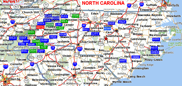
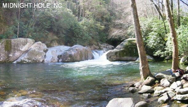
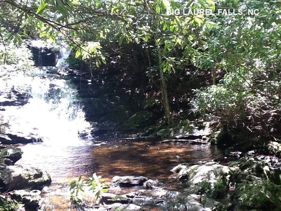
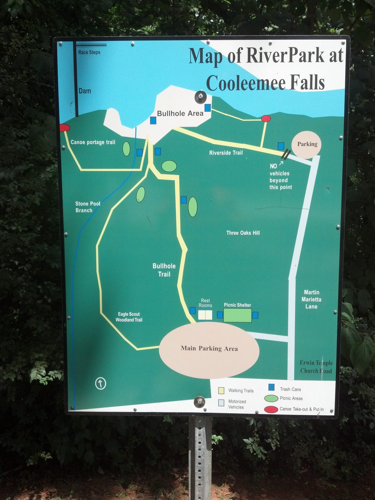
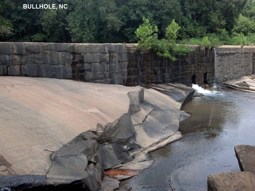
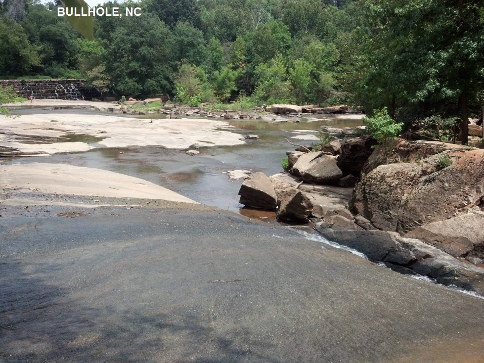
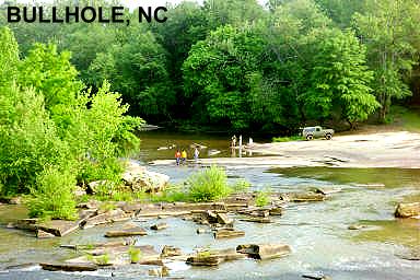
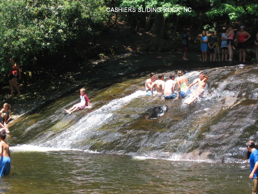
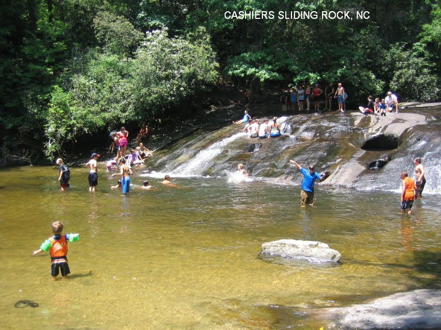
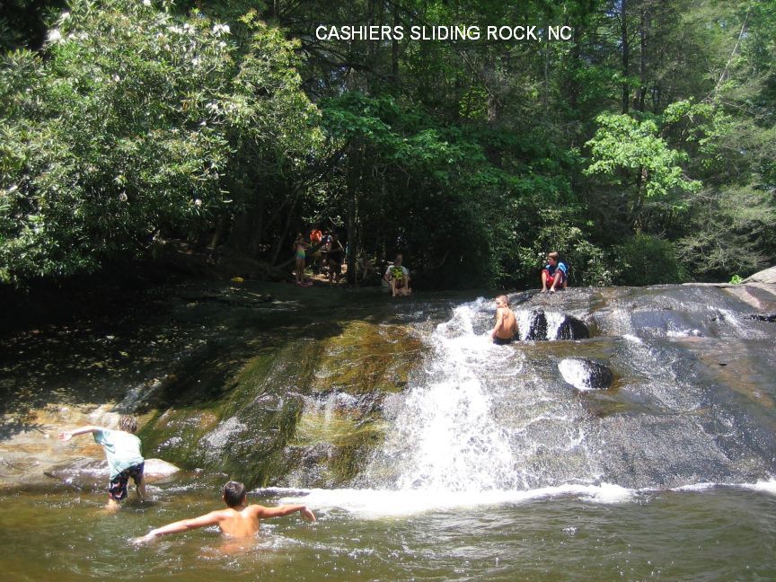
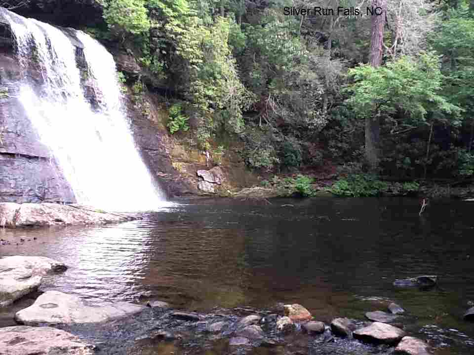
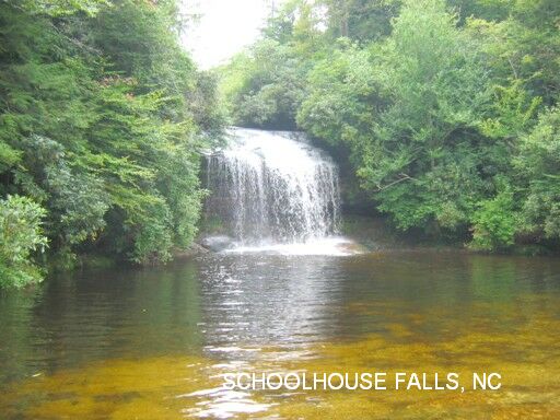
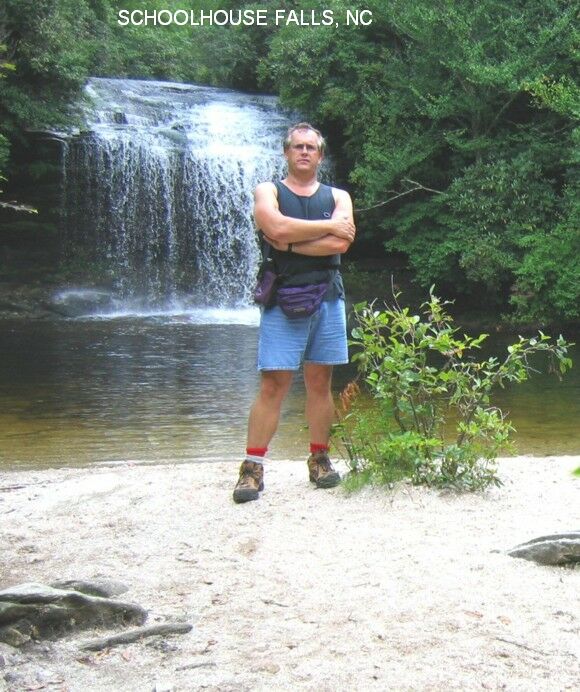
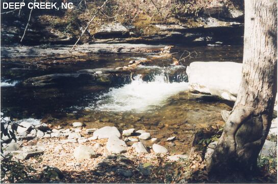
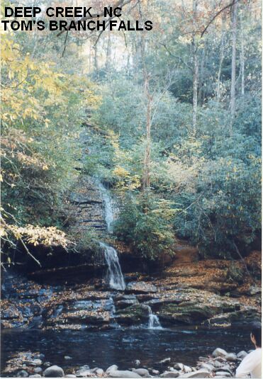
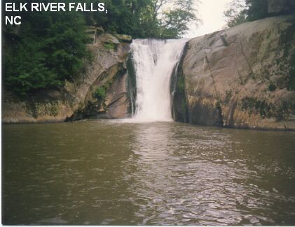
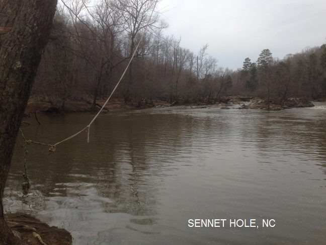
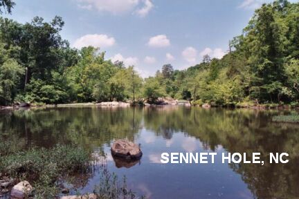
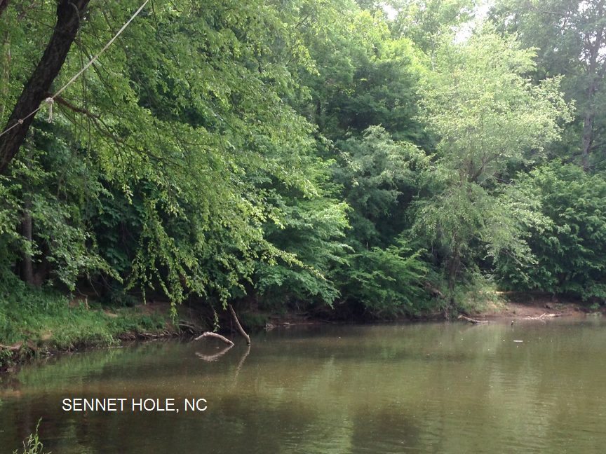
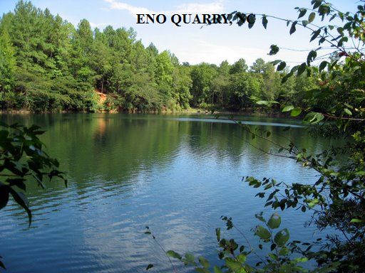
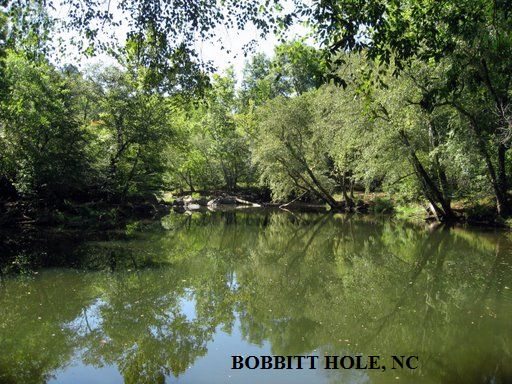
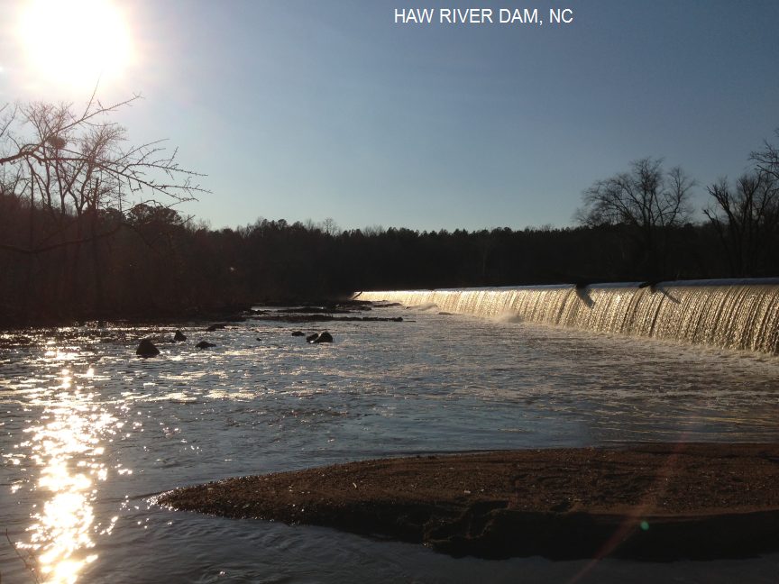
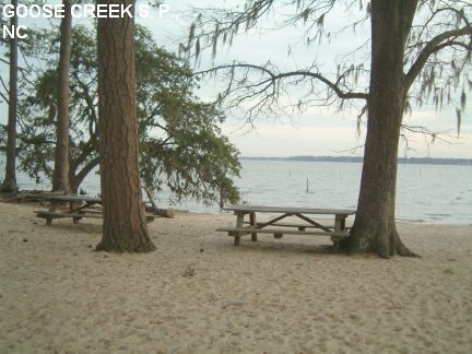
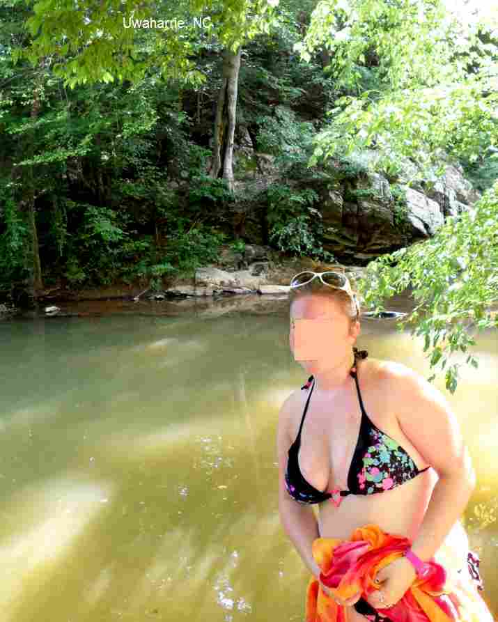
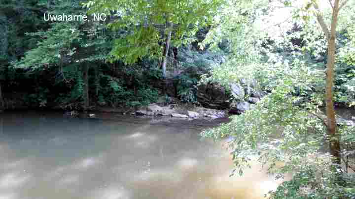
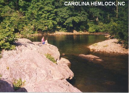
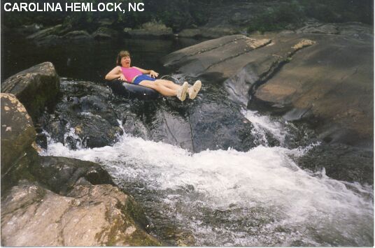
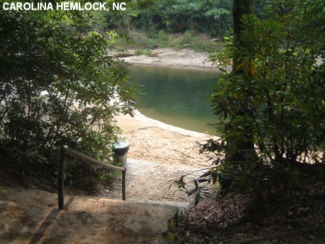
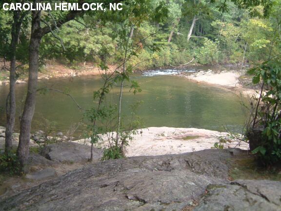
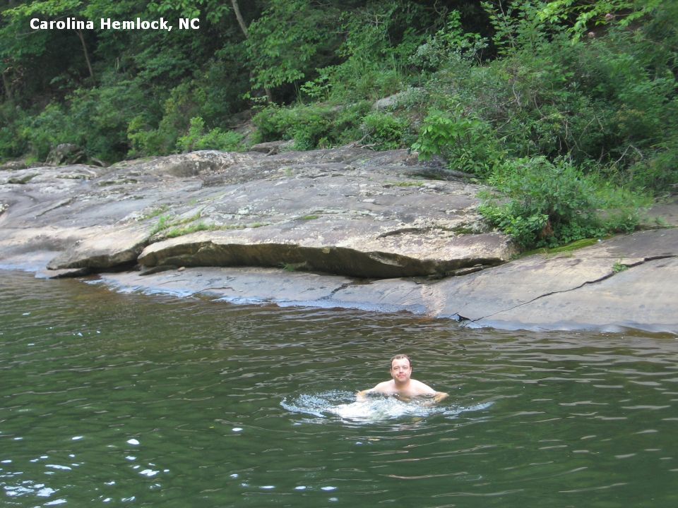
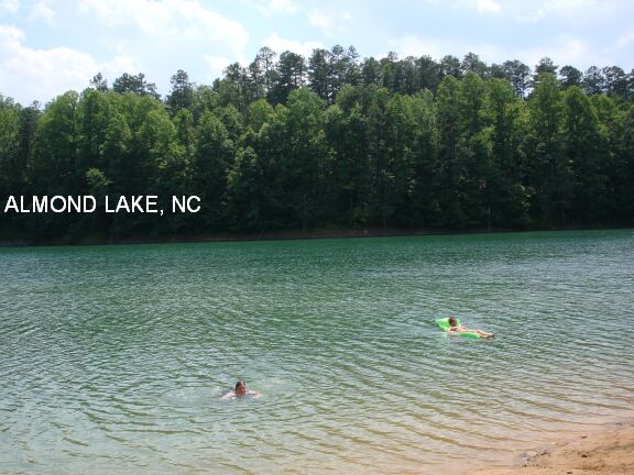
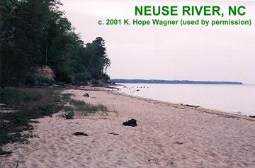
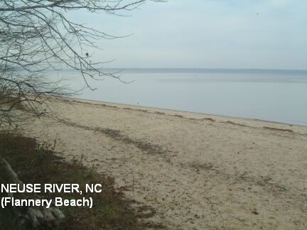
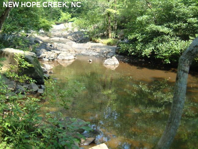
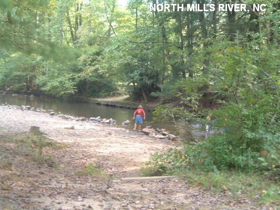
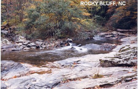
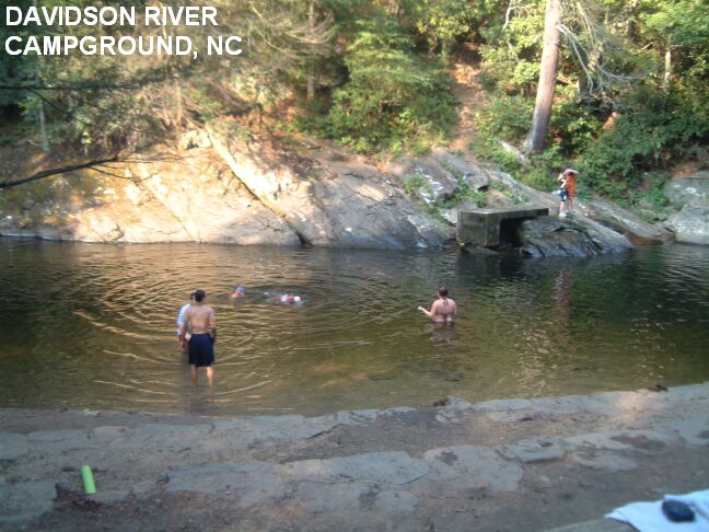
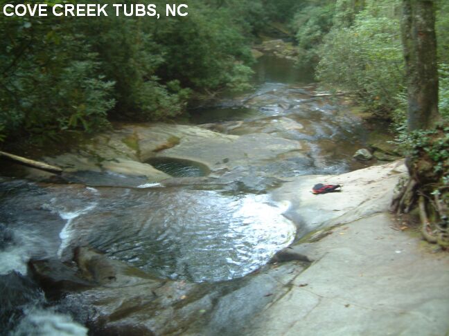
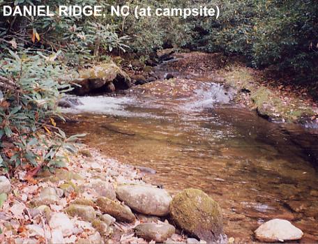
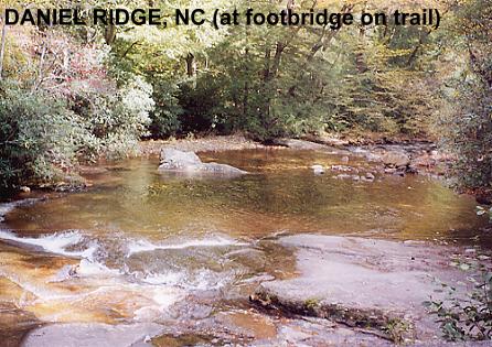
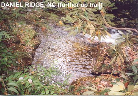
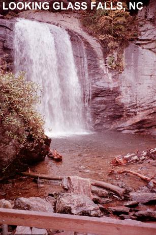
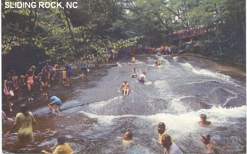
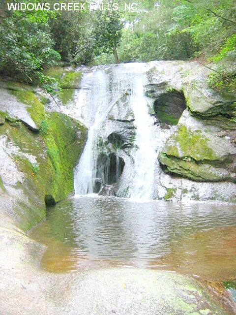
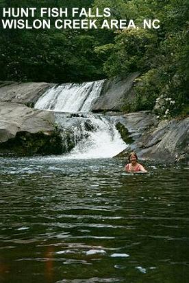
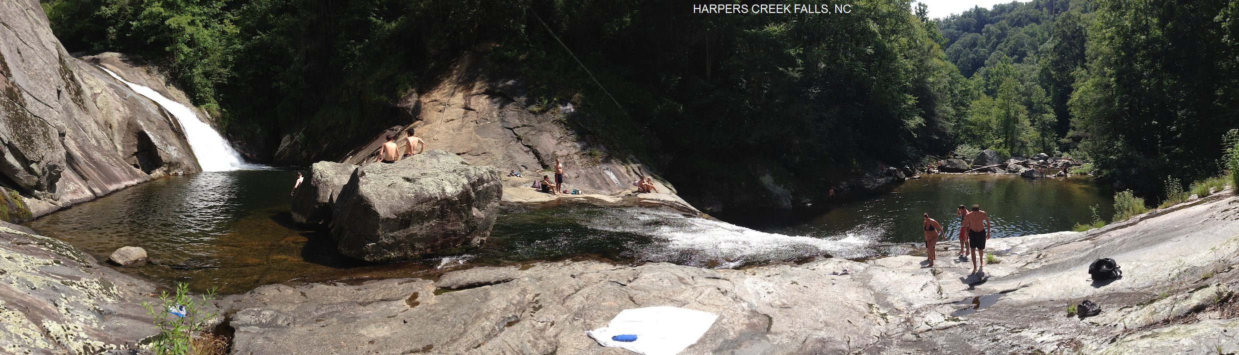
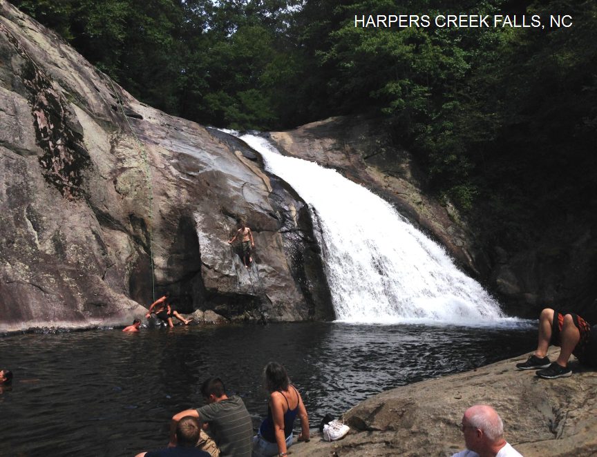
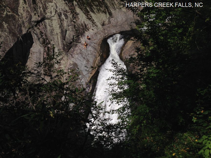
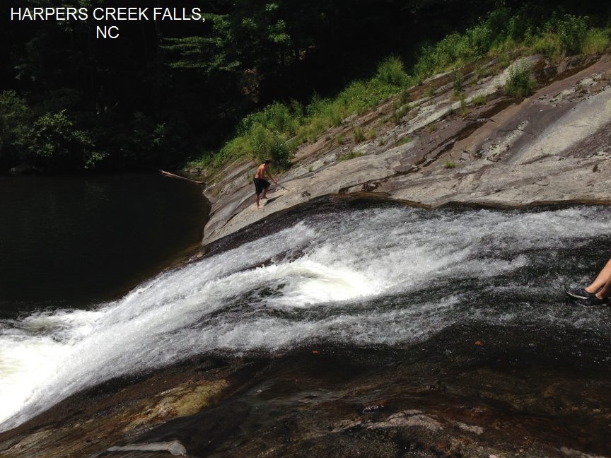
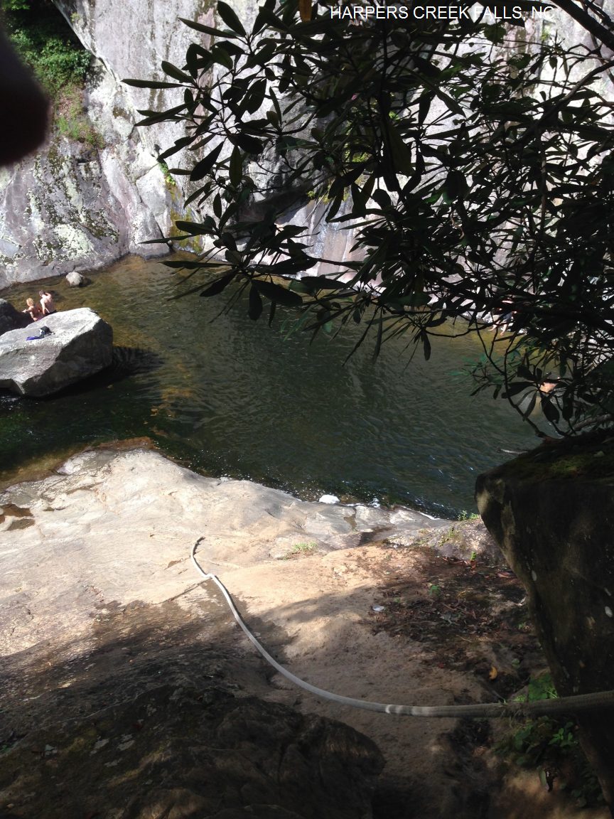
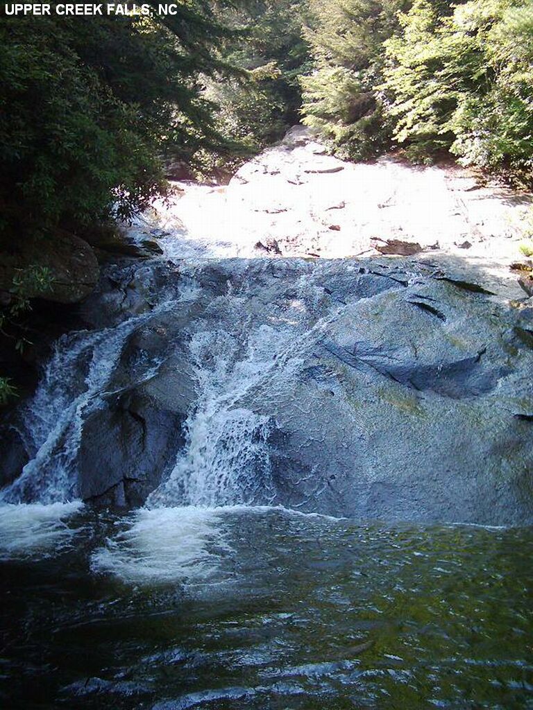
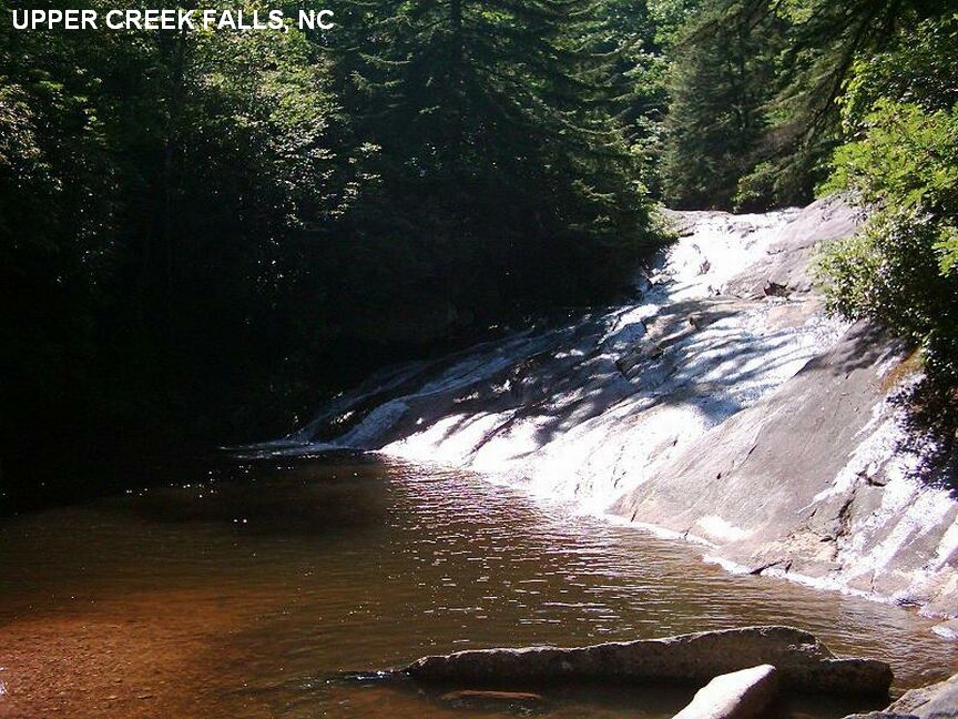
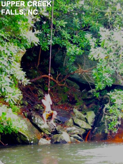
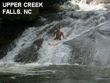
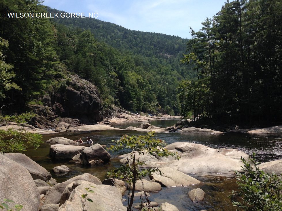
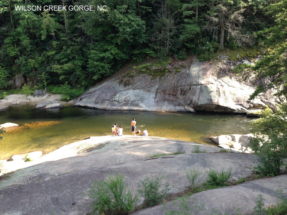
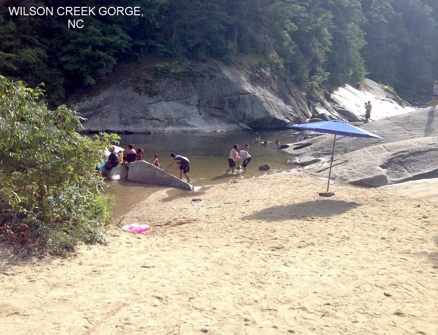
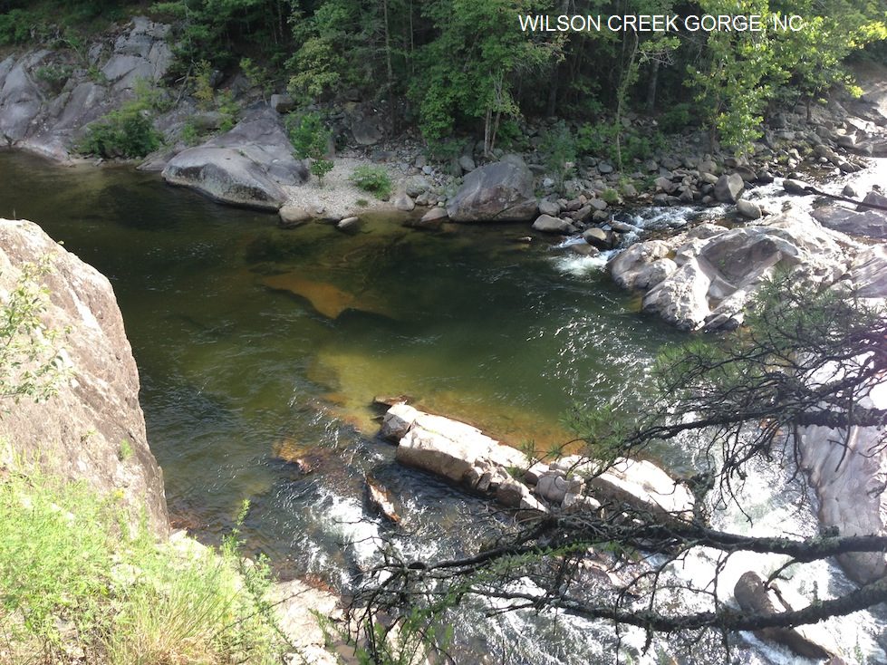
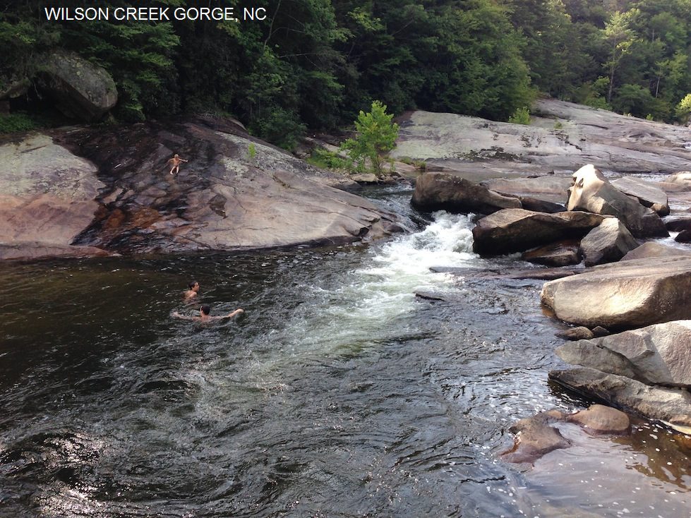