See a SLIDESHOW of swimming hole photos in this state.
This swimming hole listing is by
www.swimmingholes.org
BLUE HOLE - PIGEON
(BLUP)
|
|
TOWNS | CHATTANOOGA (TN), CALHOUN, LAFAYETTE |
|---|
|
LAT, LON | lat=34.70678, lon= -85.34415(source: DeLorme)(accuracy: approximate)
LINK TO GOOGLE |
|---|
|
STATE | GA |
|---|
|
WATER | Spring |
|---|
|
TYPE | Spring-fed pool |
|---|
|
DESCRIPTION | Small but deep blue-green spring-fed hole, maybe entrance to underground cave. Caving and rock climbing nearby also. You must have a GORP Georgia Outdoor Recreational Pass to visit here,
This report from a visitor in 2009: "It is about 4-5 feet deep in places, and perfect for 5-8 people to sit and chill. Children would love it. It is divided into two pools by a high seam of rock that is about two feet beneath the water's surface. There is a campground (primitive) sponsored by the state of GA about 1/8 of a mile away. It would be perfect for people who could bring food and books for a couple of days, and there is also spelunking near there. There is a covered bulletin board with info for spelunkers and admonishments against cruelty to the bat population (thankfully). You can drive beyond the campground and right up to spring (dirt parking). The road ends at the spring." Also:� There is a pretty big rock ledge around the deep area so everyone needs to be careful. Went with my family and there were 4 of us and 4 other people and we were kind of jammed for space."
|
|---|
|
AREAS | Pigeon Mountain WMA |
|---|
|
SANCTION | Unofficial |
|---|
|
FEE | No |
|---|
|
FACILITIES |
None |
|---|
|
ACTIVITIES |
Swimming (small, deep pool) |
|---|
|
PHONE | unknown |
|---|
|
CAMPING | None at site |
|---|
|
BATHING SUITS | Optional - can wear t-shirt and shorts if you'd prefer. |
|---|
|
DIRECTIONS | From Calhoun (on I-75) take RT 136c/136 west to Lafayette. From here, take RT 193 west, go past Chamberlain Rd. then take the next left onto Blue Hole Rd. (left at the Brown Wildlife sign). The blue hole is at the end of this gravel road. |
|---|
|
CONFIDENCE | Pretty confident |
|---|
|
VERIFIED BY WEBMASTER | No |
|---|
|
DATE UPDATED | 2/2011 |
|---|
|
|---|
This swimming hole listing is by
www.swimmingholes.org
BLUE HOLE - KINCHAFOONEE
(BLUK)
|
| TOWNS | ALBANY |
|---|
|
LAT, LON (CENTURY RD) | lat=31.67493, lon=-84.18740(source: Map)(accuracy: approximate)
LINK TO GOOGLE |
|---|
|
STATE | GA |
|---|
|
WATER | Kinchafoonee Creek |
|---|
|
TYPE | Creek |
|---|
|
DESCRIPTION | Long-time local swimming hole in creek. Trash and noise have been a problem here. There are homes across the creek. Someone dumped nails in here in summer 2012 but through concerted local effort these have been mostly removed and it is considered safe again. Please respect this place and carry out all trash. |
|---|
|
AREAS | None |
|---|
|
SANCTION | Unofficial |
|---|
|
FEE | No |
|---|
|
FACILITIES |
None |
|---|
|
ACTIVITIES |
Swimming, Rope swing |
|---|
|
PHONE | None |
|---|
|
CAMPING | None at site |
|---|
|
BATHING SUITS | Customary |
|---|
|
DIRECTIONS | From Albany, take RT 520 (Liberty Expwy) west a short way then turn north on Palmyra Rd. then turn right (east) on Century Rd.. Here the directions get very uncertain (better to ask someone near here where the Blue Hole is) : Continue on Century Rd. to just before you cross the creek and look for a (dirt?) road off to the right (not certain of where this is or the name of this road - this road is likely NOT in your gps, so you cannot navigate to here). Go down this road about 1.2 miles and turn left on a short spur to the creek. The Blue Hole is here at LAT, LON (Blue Hole) lat=31.66464, lon=-84.18308(source: map)(accuracy: approximate) LINK TO GOOGLE |
|---|
|
CONFIDENCE | Very uncertain |
|---|
|
VERIFIED BY WEBMASTER | No |
|---|
|
DATE UPDATED | 12/2012 |
|---|
|
|---|
This swimming hole listing is by
www.swimmingholes.org
CAVE SPRING
(CAVE)
|
|
TOWNS | ROME, CAVE SPRING |
|---|
|
LAT, LON | lat=34.10467, lon= -85.34532(source: DeLorme)(accuracy: exact)
LINK TO GOOGLE |
|---|
|
STATE | GA |
|---|
|
WATER | Cave Spring/Little Cedar Creek |
|---|
|
TYPE | Spring-fed pool |
|---|
|
DESCRIPTION | Cave Spring is a spring that originates in a cave and flows into a man-made swimming pool/lake the shape of Georgia (!) in Rolator Park the town of Cave Springs. Very interesting geological and historical area to visit. Can visit the cave too. Cave Spring Web Site , Wikipedia listing. |
|---|
|
AREAS | Rolarot Park |
|---|
|
SANCTION | Official |
|---|
|
FEE | Yes, $3 in 2008. |
|---|
|
FACILITIES |
Unknown |
|---|
|
ACTIVITIES |
Swimming |
|---|
|
PHONE | 706-777-0933 |
|---|
|
CAMPING | None at site |
|---|
|
BATHING SUITS | Required |
|---|
|
DIRECTIONS | From Rome (northwest of Atlanta), take RT 27 southwest to Six Mile then RT 411 sosuthwest to the town of Cave Spring. In town, turn south on Perry Farm Rd. to get to Rolator Park and the pool. |
|---|
|
CONFIDENCE | Very confident |
|---|
|
VERIFIED BY WEBMASTER | No |
|---|
|
DATE UPDATED | 10/1/2008 |
|---|
|
|---|
This swimming hole listing is by
www.swimmingholes.org
CHATTAHOOCHEE N. F.-CENTRAL AREA
[3 PLACES]
(CHAC)
|
|
TOWNS | DAHLONEGA, BLUE RIDGE, HELEN, CLEVELAND (TN) |
|---|
|
STATE | GA |
|---|
|
WATER | Varies, see below |
|---|
|
TYPE | Varies, see below |
|---|
|
DESCRIPTION | Several swimming holes at waterfalls and in creeks/rivers in the central portion of the Chattahoochee N.F.. See directions below for details. |
|---|
|
AREAS | Chattahoochee N.F. |
|---|
|
SANCTION | All unofficial |
|---|
|
FEE | No |
|---|
|
FACILITIES |
Varies, see below. |
|---|
|
ACTIVITIES |
Swimming, snorkeling, tubing |
|---|
|
PHONE | Unknown |
|---|
|
CAMPING | Varies, see below |
|---|
|
BATHING SUITS | Unknown, maybe optional at some isolated locations. |
|---|
|
DIRECTIONS | From Dahlonega, go north on RT 19/60 to where RT 60 goes off to the left (near Porter Springs) then:
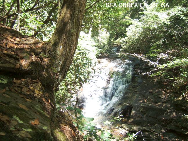
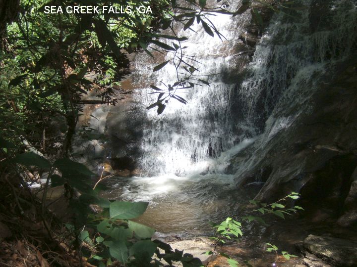
SEA CREEK FALLS [SEAC]: A waterfall you can stand under for a shower with a small plunge pool at the bottom - not really big enough for swimming but a very scenic area. PHOTO , PHOTO , PHOTO . To get here from Porter Springs (above), where RT 60 departs from RT 19 TAKE RT 60 north (left turn)toward Suches. Before the town of Cooper Creek, turn northeast (right) onto FS 6 (toward Cooper Creek Rec Area) and go about 4 miles to a sign on the left for Sea Creek Falls. Park and walk a short way to the falls. Another 2 miles or so on FS 6 brings you first to Mauch Campground then to Cooper Creek campground (a nicer place to camp). LAT, LON : lat=34.77381, lon= -84.09702 (source: measured) (accuracy: approximate) LINK TO GOOGLE Verified 7/07. Very confident. Updated 7/18/07
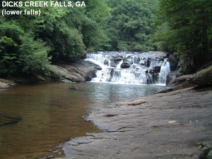
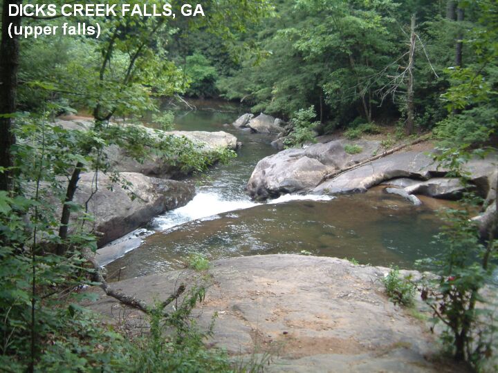
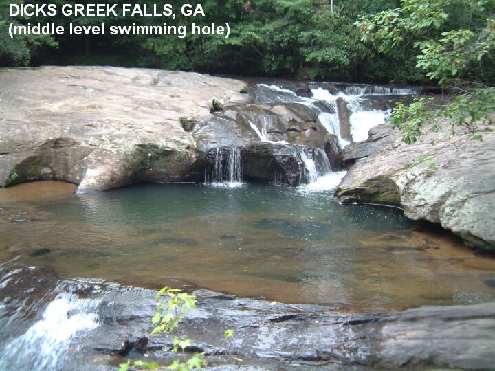
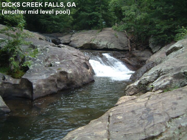
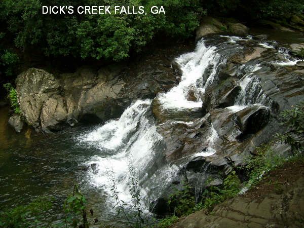
DICKS CREEK [DICK]: A popular, beautiful multi-tiered waterfall with many swimming holes. PHOTO , PHOTO , PHOTO , PHOTO , PHOTO , YOUTUBE ,
YOUTUBE . No facilities. To get here from Porter Springs (above) CONTINUE on RT 19. About .5 miles before you get to Turner's Corner (intersection of RT 19 with RT 129/11) turn left at a sign that says "Chestattee WMA" (Dick's Creek Rd). Follow this road about 2.8 miles to a large parking area with signs. The waterfalls and swimming holes are on the left. LAT, LON : lat=34.67950, lon= -83.93702(source: measured) (accuracy: approximate) LINK TO GOOGLE Verified 7/07. Very confident. Updated 7/18/07.
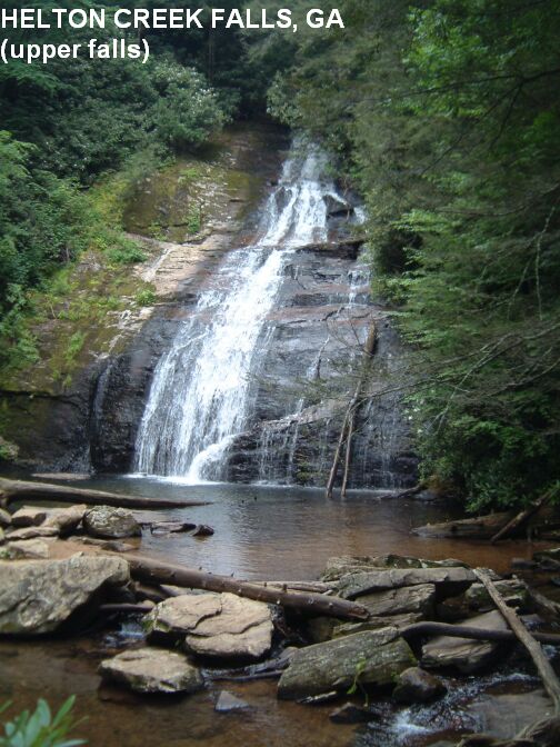
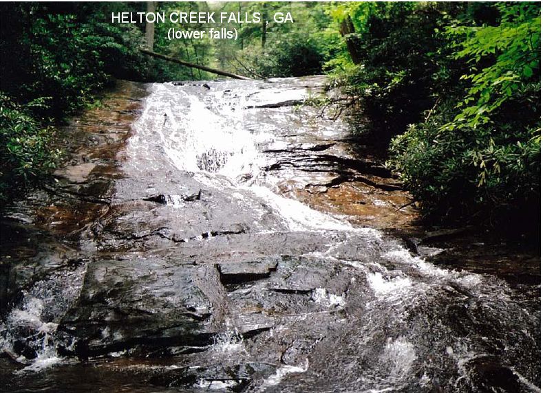
HELTON CREEK FALLS [HELT]: Here are two falls with a well-maintained path and an observation platform for the upper falls. At the bottom of the upper falls there is a deep pool but swimming is prohibited there. The lower falls has shallow pools, not deep enough to swim but good for playing in the water and cooling off. PHOTO . PHOTO . To get here from Dicks Creek Falls (above) continue north on RT 19 all the way to the vicinity of Vogel S. P.. About 1.5 miles BEFORE you get to Vogel S. P. on RT 19 (south of Vogel Park), turn east (right)at a sign that says "Helton Creek Falls" (FS 118). (It is signed "Helton Creek Falls" on the southern approach, but not the northern.) The road is paved at first while going through the Vogel Community. The road changes to gravel, and, at 2.2 miles from RT 19, there is a nice parking area for Helton Creek Falls. Camp at Vogel S. P. nearby. LAT, LON : lat=34.75257, lon= -83.89568 (source: measured) (accuracy: exact). LINK TO GOOGLE . Verified 7/07. Very confident. Updated 6/2011.
|
|---|
|
CONFIDENCE | Very confident |
|---|
|
VERIFIED BY WEBMASTER | Yes |
|---|
|
DATE UPDATED | 6/2011 |
|---|
|
|---|
This swimming hole listing is by
www.swimmingholes.org
CHATTAHOOCHEE N. F.-EAST AREA
[11 PLACES]
(CHAE)
|
|
TOWNS | GREENVILLE (SC), CLAYTON, TOCCOA |
|---|
|
STATE | GA |
|---|
|
WATER | Varies, see below |
|---|
|
TYPE | Varies, see below |
|---|
|
DESCRIPTION | Numerous swimming holes at waterfalls and in creeks/rivers in the eastern portion of the Chattahoochee N.F.. See directions below for details. |
|---|
|
AREAS | Chattahoochee N.F., Tallulah Gorge S. P. |
|---|
|
SANCTION | Unofficial |
|---|
|
FEE | Unknown |
|---|
|
FACILITIES |
Varies |
|---|
|
ACTIVITIES |
Swimming |
|---|
|
PHONE | (706)754-6221 (Chattahoochee N. F. Ranger District Office) |
|---|
|
CAMPING | Several places, see below. |
|---|
|
BATHING SUITS | Unknown |
|---|
|
DIRECTIONS | Directions below are given either from Clayton or from Helen, both are north of Atlanta in the Chattahoochee N.F. :
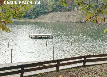
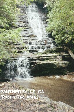
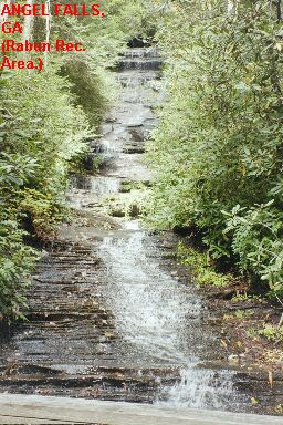
RABUN BEACH RECREATION AREA [RABU]: The Rabun Beach Recreation Area, in the Chattahoochee N.F., has a very nicely developed swimming area in Lake Rabun PHOTO-RABUN BEACH and, a short hike away, two very pretty, delicate stairstep falls, Panther Falls PHOTO-PANTHER FALLS and Angel Falls PHOTO-ANGEL FALLS . The pools at the falls are not deep enough for swimming, but Panther Falls has a large, shallow, sand bottom pool that would be good for a small one to wade and get their head under the delicate falls.
|
|
To get here from Clayton, go about 7 miles south on RT 441/23 to the sign for the Rabun Beach Recreation Area. Here, turn west (right) onto "Old 441 south". Go 2.5 miles then turn left onto "Lake Rabun Rd." Go 5.3 miles on this road, winding along the lake shore, to Rabun Beach campground. There is an official swimming area here (in camping area #1) in the backwaters of Lake Rabun, with sand beach, bathhouses and float. To hike to the falls, park in the campground parking area for Camping Area 2, and take the trail that goes upstream on Joe Branch. Hike about .5 miles on this trail to the first falls, Panther Falls, then another .25 miles to Angel Falls. No swimming possibility at falls but wading at Panther. Camp in the N. F. campground. LAT, LON :lat=34.75694, lon= -83.48194 (source: Topozone ) (accuracy: approximate). LINK TO GOOGLE Very confident. Verified 10/02.
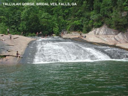
TALLULAH GORGE S. P. [TALL]: This is a spectacular gorge on the Tallulah River - 2 mi long and 1,000 feet deep. You need a permit to enter the Gorge. Second in depth to the Grand Canyon. Part of the movie "Deliverance" was filmed here. There is one waterfall where you can swim, Bridal Veil Falls. You can slide over this falls, but be very careful! PHOTO 1 , PHOTO 2.
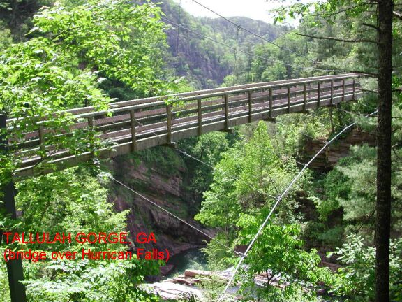
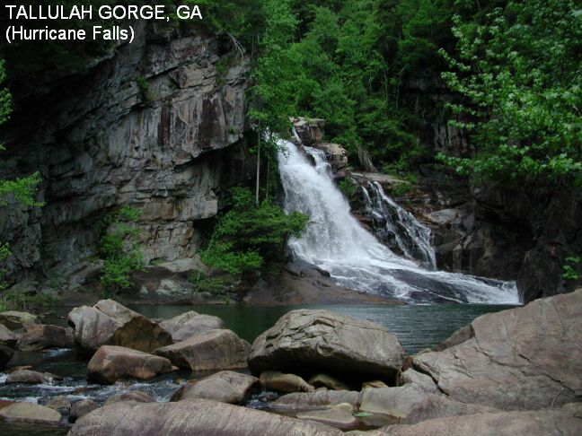
A permit is needed to have access to the gorge floor. The best procedure is to visit the Jane Hurt Yarn Interpretive Center first and obtain the permit. You can get to the Center by going in the main entrance to the park (on Route 441) and just follow the signs to the Interpretive center. A permit is required for safety reasons and it's free so there is no reason not to get one. They will also give you a map of the trails and explain how to access the gorge bottom. (For those of you who are familiar with the area: The suspension bridge over Hurricane Falls has been completed. This makes getting to the swimming area at Bridal Veil Falls much quicker and the hike more interesting.)
After obtaining a permit to access the gorge floor, follow the trail across the bridge and descend to the base of Hurricane Falls. Go through the latched gate and cross the river here. There are large boulders to use as stepping stones, but the crossing can be tricky. PHOTO 3 , PHOTO 4 . You should assume that you will get wet, though, with great care and a little ingenuity, a dry crossing is possible. If you make the return hike this way, it's a bit more difficult.
Following the shoreline, you make your way downstream past Oceana Falls and many spectacular pools. You will reach Bridal Veil Falls in about .75 miles. You can return the way you came or cross the river here above the falls, where you will most certainly get wet, climb the STEEP trail on the opposite shore and follow the rim trail back to the nature center. This route is much longer, though it will give you a view of the gorge from the top, so it is worthwhile.
To get here from Clayton, continue south on RT 441/23 about 5 miles past the turnoff for Rabun Beach Recreation Area (above) to signs for Tallulah Gorge S. P. There is camping here also.
LAT, LON lat=34.73522, lon=-83.38506 (source: measured) (accuracy: exact) LINK TO GOOGLE . Very confident. Verified by Dave Hajdasz 5/06. Updated 5/06.
PANTHER CREEK [PANT]: Continue south on RT 441/23 from Tallulah Gorge S. P. a short distance to the signs for Panther Creek Recreation Area. Turn west (left) here and continue a few miles to the well-signed Panther Creek Recreation Area. Fee required. It is about a 3.5 mi hike from the parking place to the Panther Creek swimming holes; good fishing too. The day-use area has several picnic tables, chemical toilets and two covered
picnic areas.
From a recent visitor: "The 3.5 mile (blue blaze) hike is easy to moderate. Two primitive campsites were spotted along the trail, one right next to the creek. The most impressive waterfall, which may be Panther Creek Falls, descends around a corner into a small pool filled with strainers & fallen logs. You can hear the roar of the water as you approach. It's possible to slide down a portion, but be
quick to maneuver out before hitting wood. At the end of the trail (red flag tied to two steel cables strung between two trees), there is a very steep & muddy climb down to a shallow swimming hole with a sliding rock. It was beautiful until we discovered LEECHES clinging to the sliding rock & us. Overall, the hike was beautiful and the water refreshing. Definitely a nice daytrip area, just be mindful of leeches." Very confident.
DAY USE AREA: LAT, LON lat=34.69967, lon=-83.42103(source: DeLorme ) (accuracy: exact) LINK TO GOOGLE . SWIMMING HOLE: LAT, LON lat=34.72458, lon=-83.45375(source: DeLorme ) (accuracy: approximate) LINK TO GOOGLE . Partially verified (location of trailhead verified, swimming holes not verified), 10/02. Updated 3/16/2003.
TALLULAH RIVER AREA [TALR]: There are said to be many wonderful swimming holes in the Tallulah River north of Persimmon along Tate City Rd. (forest road 70), which parallels the Tallulah River. You've just kinda got to look for them, but there are at least 10 great ones. A specific one is at Sandy Bottom, a National Forest campground. It's two 4 foot deep pools right beside each other, in the middle of the campground - but it's the least cool one - there are better ones along this road. LAT, LON : lat=34.94808, lon= -83.55136(source: Topozone ) (accuracy: general area). LINK TO GOOGLE . To get here, from Clayton: Take RT 76 west for about 8 miles then turn north (right) on Persimmon Rd., go 4 miles and take left on FR 70 (Tallulah River Rd.?) then turn right on Tate City Rd., which closely parallels the Tallulah River. Along here there are three forest service campgrounds - Tallulah River, Tate Branch, and Sandy Bottom. The 4 foot deep places (mentioned above) are at Sandy Bottom, but most of the good holes are between Tallulah River campground and Tate Branch campground. The best one (actually 2, side by side) are right before a bridge,
with the river on the right side of the road. Obviously there is plenty of camping and rest rooms at the campgrounds. Not verified. Pretty confident. Updated 12/28/2006.
|
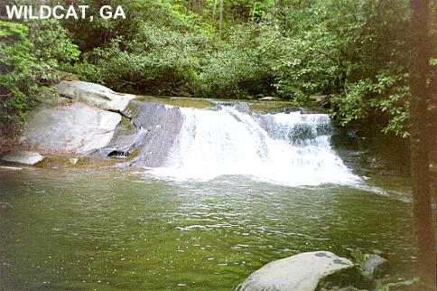
WILDCAT CREEK [WILD]: An excellent sliding rock and large, deep swimming hole in a scenic setting on Wildcat Creek. Water flows down a flat stone, making a natural water slide. PHOTO It is in the Lake Burton Wildlife Management Area, Chattahoochee National Forest. To get there from Clayton go west on RT 2/76 then turn south (left) on RT 197. Go 3.9 miles - past East Wildcat Creek Rd. - to FR 26, West Wildcat Creek Rd. (dirt surface), and turn west (right) and parallel scenic Wildcat Creek.
| |
In about 1.4 miles, there are several "no parking" signs on the road; this is where the swimming hole is (visible from the road). Just past these signs, there is a wide place on the left side of the road where you can park and walk back a short distance to the swimming hole and rock slide. There are two nice camping areas further up this road, the first about 1.5 miles past the swimming hole. There is no drinking water at these campgrounds, bring water with you. LAT, LON :lat=34.83344, lon= -83.60650(source: measured) (accuracy: exact). LINK TO GOOGLE Very confident. Verified, 5/02.
BURRELL FORD [BURR]: Burrell Ford is on the Chattooga River in the extreme northeastern corner of GA, on the border with SC and not far from NC. It is listed on our South Carolina page, so click below to go to SC and scroll down under Sumter N. F. Area to find Burrell Ford, then use "RETURN" to come back here. Link to Burrell Ford on SC page.
SANDY FORD [SAND]: Sandy Ford is on the Chattooga River in the extreme northeastern corner of GA, on the border with SC and not far from NC, downstream from Burrells Ford. There is a 10.7 mile trail, called the Chattooga River Trail, paralleling (but not very close for most of its length) the river along the north (GA) side. It follows the river from RT 76 to Sandy Ford Rd. (also known as Dick's Creek Rd.). About 3 miles before you get to the Sandy Ford Rd. end, there are said to be deep swimming holes with sandy beach and boulders. Bathing suits are said to be optional here.
Here is a description from a happy visitor, received 10/02 "There is a beautiful waterfall here, which I believe is confluence of Dicks Creeks and the Chattooga. The ledge can be dangerous at spots because of the way the water runs over it. A friend's son almost drowned there, but above the ledge, there is a beautiful swimming "hole," though its really just the river. We camp right there on the river, too, and it is gorgeous. I love to
visit this place, and it' s accessible by the road, and by the trail. Definitely worth the visit!!"
SO BE CAREFUL HERE!
To get here: These directions are to the Sandy Ford Rd. end of the trail: In Clayton, when RT 76 goes west, turn east onto Rickman St. (also known as War Woman Rd.). Go about 6 miles and turn south (right) onto Sandy Ford Rd. (also known as Dicks Creek Rd.) (Sandy Ford Rd. crosses creeks twice, you must ford in your car. CHECK THE DEPTH each time before you ford. If you cannot proceed, park your car safely out of the road and walk.) On this road, keep to the right (stay on main road) for about .75 miles then turn left across a bridge. Go about 3.5 miles more to the sign for the Bartram Trail and park.
The Chattooga River Trail meets the Bartram Trail near here. You want to take the Chattooga River Trail south about 3 miles to the deep pools with sandy beaches and boulders. This is the swimming place. LAT, LON : lat=34.9545, lon= -83.1246(source: Topozone ) (accuracy: approximate) LINK TO GOOGLE . Not verified. Pretty confident.
WOODALL SHOALS [WOOD]: Swimming place in the Chattooga River in the Chattahoochee N.F. To get here From Clayton, travel east on RT 76 across the Chattooga River to Orchard Road (10.7 miles from Clayton)(the first paved road to the right after the river); turn right on Orchard Road; travel .3 mile to the first dirt road to the right; turn right; travel 2.2 miles to the parking area. Follow the paths to the river. CAUTION - VERY DANGEROUS RAPIDS NEARBY - Do NOT swim in the rapids. An eddy about 25 yards DOWNSTREAM provides a safer place to swim. DO NOT SWIM IF RIVER FLOW LEVEL IS HIGH. There have been many deaths on the Chattooga, and the river is extremely dangerous. Swimmers must exercise enormous caution. LAT, LON :lat=34.79750, lon= -83.31392(source: DeLorme)(accuracy: exact) LINK TO GOOGLE
BULL SLUICE [BULL]: Swimming place in the Chattooga River in the Chattahoochee N.F. To get here From Clayton, travel east on RT 76 across the Chattooga River to the Chattooga, cross the river and turn left into the parking area (8.2 miles from Clayton). Follow the paths to the river. CAUTION - VERY DANGEROUS RAPIDS NEARBY - Do NOT swim in the rapids. About 100 yards DOWNSTREAM provides a safer place to swim. DO NOT SWIM IF RIVER FLOW LEVEL IS HIGH. There have been many deaths on the Chattooga, and the river is extremely dangerous. Swimmers must exercise enormous caution. LAT, LON :lat=34.81783, lon= -83.30403(source: DeLorme)(accuracy: general area) LINK TO GOOGLE
|
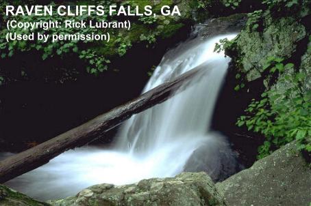
RAVEN CLIFFS FALLS [RAVE]: The Raven Cliffs Falls Trail is a very beautiful hike along the scenic Dodd's Creek. There are several falls, including Raven Cliffs Falls, and other swimming places along the way. It is about a 2.5 mile hike one way to the Raven Cliffs Falls but there are swimming places much before this point. PHOTO OF FALLS. Camp at Andrew's Cove N.F. campground on RT 75 north of here.
| |
To get here: From Helen, go north on RT 75 about 1.5 miles then left on RT 75 Alt. for 2.3 miles then turn right on the Richard Russell Scenic Highway (RT 348). Go 2.8 miles to a large sign for the Raven Cliffs Trailhead and parking area (parking fee) on the left. Park and hike the trail along Dodd's Creek. As soon as you begin this trial, on the right, there is a large informal camping area under tall trees and a swimming hole with a rope swing. Within a 2.5 mile one-way hike up this trail, there are at least 5 small falls and other swimming places. No more specific directions. Very scenic hike. LAT, LON : lat=34.71861, lon= -83.80917(source: Topozone ) (accuracy: approximate) LINK TO GOOGLE Partially verified, 5/02. Very confident.
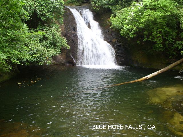
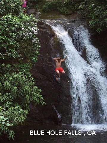
BLUE HOLE FALLS [BLUE]: The High Shoals Trail is a nice hike to the High Shoals Creek. There are two falls, but the only one that appears to have a swimmable pool at the bottom is one called the "Blue Hole Falls". NOTE: Swimming is not permitted at the falls. PHOTO 1 , PHOTO 2 . BE VERY CAREFUL HERE- THERE ARE SOMETIMES STRONG CURRENTS AND FALLEN TREES IN THE POOL. Camp at Andrew's Cove N.F. campground on RT 75 south of here. To get here: From Helen, go north on RT 75 about 11 miles then right on Indian Grave Gap Rd. (FS 283). This is a sometimes-rough dirt/gravel road, but is usually passable with an ordinary car. (If you cannot drive all the way to the trailhead, park safely out of the road and walk the rest of the way along the road.) It is about 1.5 miles from RT 75 to the large, well marked parking area for the trailhead. You must drive through a stream on the way - CHECK THE DEPTH BEFORE DRIVING THROUGH - it is usually shallow enough to drive through.
From the trailhead, (parking fee) hike about 1 mile and you will see in the middle of the trail a very large, block-shaped boulder and, shortly thereafter, an unmarked side trail angling sharply off to the left. Take this trail off to the left and you will quickly come to the Blue Hole Falls, where there is a wooden observation deck. As with all "Blue Holes", this is a traditional swimming place, even though the deck now seems to present a bit of a barrier, but it is easily walked around to get to the water. BE VERY CAREFUL HERE- THERE ARE SOMETIMES STRONG CURRENTS AND FALLEN TREES IN THE POOL. LAT, LON : lat=34.821343, lon= -83.722558(source: measured) (accuracy: approximate) LINK TO GOOGLE . Verified 5/02. Very confident.
|
|---|
|
CONFIDENCE | See above |
|---|
|
VERIFIED BY WEBMASTER | See above |
|---|
|
DATE UPDATED | 10/1/2008 |
|---|
|
|---|
This swimming hole listing is by
www.swimmingholes.org
This swimming hole listing is by
www.swimmingholes.org
DIVING ROCK
(DIVI)
|
|
TOWNS | ATLANTA, MARIETTA, VININGS |
|---|
|
LAT, LON | lat=33.87732, lon= -84.44212(source: DeLorme)(accuracy: approximate)
LINK TO GOOGLE |
|---|
|
STATE | GA |
|---|
|
WATER | Chattahoochee River
|
|---|
|
TYPE | River |
|---|
|
DESCRIPTION | Popular swimming hole in the famous Chattahoochee River very close to (north of) Atlanta. Gets some pretty big crowds on hot Georgia days. Two cautions: 1) DO NOT DIVE HERE - while it is called "diving rock", diving is very dangerous, jump only and be cautions about that too, 2) This river is often polluted, especially after heavy rain, but I am told this is mostly south of Atlanta, not north. You may want to check this out for yourself.
|
|---|
|
AREAS | Chattahoochee River National Rec. Area
|
|---|
|
SANCTION | Unofficial |
|---|
|
FEE | None |
|---|
|
FACILITIES |
Unknown |
|---|
|
ACTIVITIES |
Swimming, Jumping |
|---|
|
PHONE | Unknown |
|---|
|
CAMPING | Unknown |
|---|
|
BATHING SUITS | Customary |
|---|
|
DIRECTIONS | From I-75 in northwest Atlanta (south of the interchange with I-285) take Exit 256 (RT 41 and/or Mount Paran Road). Then:
One way: take Mount Paran Rd. north then go left on Harris Trail. At Whitewater Creek Rd., go left. Park in the National Park Service parking area, on the right side of the road. Walk from here to the Diving Rock swimming hole.
Another way: You can also get to the Chattahoochee from this same I-75 exit by taking Northside Pkwy NW (RT 41/3) to where it crosses the river then parking in the riverside parking lot here: parking place.
Yet another way: Take the 12 bus which goes from Midtown Atlanta station every half hour to Vinings Mall (200 yards from the bridge / carpark).
This from a visitor in 2010: (We would strongly suggest a life jacket if you go with the flow here and always go feet first.) "You can walk upstream and get quite a long downstream swim (about 3 miles if you walk all the way up I think) - map to it (see Palisades west of the river map). There are 3 or 4 decent rapids sections to swim down which are fun. The currents are pretty strong, but nothing you can't swim over (I went feet first for a couple). There's a car park at both ends, so you can shuttle it and not have to walk back for your gear afterwards. I just hid a spare pair of shoes at the downstream end and ran back in for my bag."
|
|---|
|
CONFIDENCE | Pretty confident |
|---|
|
VERIFIED BY WEBMASTER | no |
|---|
|
DATE UPDATED | 4/2010 |
|---|
|
|---|
This swimming hole listing is by
www.swimmingholes.org
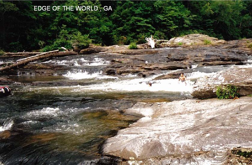
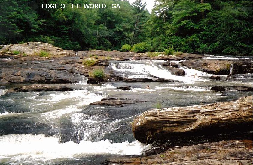
EDGE OF THE WORLD
(EDGE)
|
|
TOWNS | DAHLONEGA, DAWSONVILLE |
|---|
|
LAT, LON | lat=34.423917, lon= -84.214833 (source: geocaching.com)(accuracy: approximate)
LINK TO GOOGLE |
|---|
|
STATE | GA |
|---|
|
WATER | Amicalola Creek |
|---|
|
TYPE | River/Rapids |
|---|
|
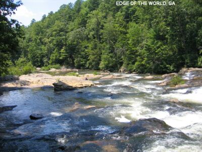
DESCRIPTION | Edge of the World rapids is a great local swimming hole and picnic spot. There are a number of fun water slides and chutes to go down. There are some quiet pools of water just below the rock ledges. Caution: Slippery on moss covered rocks. [See also POOLES MILL swimming hole, nearby.]
|
|---|
|
AREAS | Dawson Forest W.M.A. |
|---|
|
SANCTION | Unofficial |
|---|
|
FEE |
This note from a visitor in 2015:"You DO need a pass, but
it's not a hassle to get. It's $6.00 on-line, but be advised that you have
to have it with on (on your person), not in your car. The ranger DID come
by. He didn't fine anyone, he DID escort a bunch of people out from the
swimming hole at EDGE, Be advised that the walkway is about a mile
long to the Edge of the World and that there are two obvious unimproved
trails when you get to the end. Don't take the left one, which goes up.
You get to the top of a hill and the trail ends. The one to the right takes
you to the water, " |
|---|
|
FACILITIES |
None |
|---|
|
ACTIVITIES |
Swimming, Sliding |
|---|
|
PHONE | Unknown |
|---|
|
CAMPING | Unknown |
|---|
|
BATHING SUITS | Customary |
|---|
|
DIRECTIONS | From Atlanta, take GA 400 north, to just past the N. Georgia Premium Outlets. Turn left at the strip mall onto RT 53 west. Go 6.3 miles to the three way stop sign. Veer left and stay on RT 53 towards Tate, GA. Go 6.1 miles to the gravel parking lot just before you cross the bridge over the river. Park and take the wooden stairwell down to the river and follow the boardwalk downstream. When the boardwalk ends you will be at the main (often crowded) swimming hole but if you continue on the unimproved but obvious trail another 100 yards the river will bend out of sight of the crowds. |
|---|
|
CONFIDENCE | Very confident |
|---|
|
VERIFIED BY WEBMASTER | By another, 6/09 |
|---|
|
DATE UPDATED | 2/14/2016 |
|---|
|
|---|
This swimming hole listing is by
www.swimmingholes.org
FARGO
(FARG)
|
|
TOWNS | VALDOSTA, FARGO |
|---|
|
LAT, LON | lat=30.68222, lon= -82.55992(source: DeLorme)(accuracy: approximate)
LINK TO GOOGLE |
|---|
|
STATE | GA |
|---|
|
WATER | Suwanee River |
|---|
|
TYPE | River |
|---|
|
DESCRIPTION | Swimming hole in the famous Suwanee River in the town of Fargo just west of the legendary Okefenokee Swamp, at the site of the "Suwanee River Visitor Center". The Suwanee River begins in the Okefenoke Swamp and meanders southwest into Florida. There are alligators in this river - see Alligator safety cautions. The river presents a beautiful sight as it flows swiftly past the town of Fargo, through a grand array of moss draped cypress. |
|---|
|
AREAS | Near the Okefenokee N.W.R. |
|---|
|
SANCTION | Unofficial |
|---|
|
FEE | None |
|---|
|
FACILITIES |
Toilets and tables at the "Suwanee River Visitor Center" |
|---|
|
ACTIVITIES |
Swimming |
|---|
|
PHONE | Unknown |
|---|
|
CAMPING | Unknown |
|---|
|
BATHING SUITS | Unknown |
|---|
|
DIRECTIONS | From Valdosta, take RT 94 east to the town of Fargo, near the Okefenokee N.W.R. Just past Fargo, RT 94 crosses the Suwanee River. The area of the river in the immediate proximity of the "Suwanee River Visitor Center" just east of Fargo is a local swimming hole. |
|---|
|
CONFIDENCE | Very confident |
|---|
|
VERIFIED BY WEBMASTER | Yes, 3/2013 |
|---|
|
DATE UPDATED | 3/2013 |
|---|
|
|---|
This swimming hole listing is by
www.swimmingholes.org
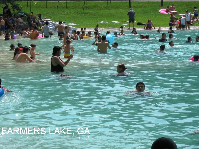
FARMERS LAKE
(FARM)
|
|
TOWNS | DALTON, CHATTANOOGA(TN), COHUTTA |
|---|
|
LAT, LON | lat=34.961592, lon= -84.952628(source: DeLorme)(accuracy: approximate)
LINK TO GOOGLE |
|---|
|
STATE | GA |
|---|
|
WATER | Farmers Lake |
|---|
|
TYPE | Spring-fed lake |
|---|
|
DESCRIPTION | Farmer's Lake, Inc. is concreted to a depth of 6 ft and other area is .gravel bottom to allow spring water flow. Estimated spring water output 1.2 million gallons per day, which ensures fresh water supply. Kiddie pool. It is open daily 10AM -6PM for swimming for family type atmosphere recreation. Admission is $5 per person (as of Summer 2009). After hour rental 6-9PM for private parties, civic groups. Discounts to non-profit organizations. Certified lifeguards on duty during hours of operation.
This report from a visitor in 2009:"Farmers lake was only $5.00 for the day. It is wonderful to me, but I have a nostalgia for these places as I am 45, and place like this reminds me of my childhood excursions with my family. There is a modest sandwich shack on the property and showers and restrooms. The water is amazing, and you can find any depth you like to control the temperature. The is a high dive, and a water diving board in the center (deepest ) part of the pond/spring. In the deep end the bottom is natural and very cold. It also wasn't very crowded when I was there."
|
|---|
|
AREAS | None |
|---|
|
SANCTION | Official - lifeguards |
|---|
|
FEE | $5.00 per person |
|---|
|
FACILITIES |
Picnic tables and charcoal grills are available. Volley ball court, game room and snack bar on grounds. |
|---|
|
ACTIVITIES |
Swimming |
|---|
|
PHONE | 706-694-8018 or 423-838-2112 |
|---|
|
CAMPING | None at site |
|---|
|
BATHING SUITS | Required |
|---|
|
DIRECTIONS | From Dalton, go north on RT 71 about 15 miles then west (left) on Wolfe Rd. to Cohutta. In Cohutta, turn north (right) on Red Clay Rd. and go a short distance to 5510 Red Clay Rd.. Farmer's Lake is here. |
|---|
|
CONFIDENCE | Very certain |
|---|
|
VERIFIED BY WEBMASTER | no |
|---|
|
DATE UPDATED | 12/28/2009 |
|---|
|
|---|
This swimming hole listing is by
www.swimmingholes.org
HOLLY CREEK AREA
[2 PLACES]
(HOLL)
|
|
TOWNS | DALTON, ETON |
|---|
|
LAT, LON | lat=34.81175, lon= -84.73511(source: DeLorme)(accuracy:general area)
LINK TO GOOGLE |
|---|
|
STATE | GA |
|---|
|
WATER | Holly Creek |
|---|
|
TYPE | Creek |
|---|
|
DESCRIPTION | Swimming holes in Holly Creek east of Eton. One is a designated swimming area, the others are unofficial. See DIRECTIONS below for details. |
|---|
|
AREAS | Chattahoochee N.F. |
|---|
|
SANCTION | Varies - see below |
|---|
|
FEE | None |
|---|
|
FACILITIES |
Unknown |
|---|
|
ACTIVITIES |
Swimming, jumping |
|---|
|
PHONE | Unknown |
|---|
|
CAMPING | Primitive camping in the National Forest. You can also camp on the top of the mountain past holly creek on what is called Grassy Mountain. There is an open grassy clearing called the ball ground at the top where many people camp. (Lake Conasauga is also at the top and you may be able to swim there also.) There is also developed camping south of here - just east of Chatsworth at Fort Mountain S.P. |
|---|
|
BATHING SUITS | Customary |
|---|
|
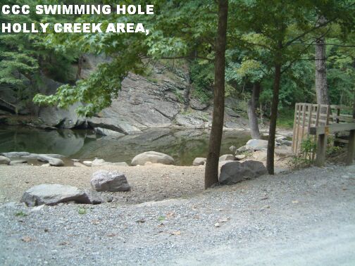
DIRECTIONS | From Dalton, go east on RT 76/52 to Chatsworth. Then go north on RT 61/2/411 to Eton. In Eton, go east on the CCC Camp Road (turns to gravel road), then:
CCC SWIMMING HOLE [CCCS]: A very nicely developed old CCC swimming hole - a fine family place - in Holly Creek. Low rocks that one can jump from. PHOTO 1 , PHOTO 2 . To get here, go about 6.5 miles on the CCC road from Eton and it is right by the road on the left side. LAT, LON : lat=34.81368, lon= -84.65531 (source: measured) (accuracy:exact) LINK TO GOOGLE . Verified 8/2006. Very confident. Updated 9/6/06.
CCC WATER FALL [CCCW]: If you go up this road a very short distance further from the CCC swimming hole there is a parking lot on the left next to a trail that goes up to a waterfall. Along this trail there are trails going down the incline towards the creek. They require some careful climbing going up and down. If you follow these there
are some great swimming holes, and at one point about halfway up to the waterfall at the end of the trail there are some cliffs that some people use for jumping BUT PEOPLE HAVE BEEN PARALYZED AFTER JUMPING ON A ROCK THAT LIES HIDDEN JUST UNDERNEATH THE WATER AT THIS HOLE. LAT, LON (of parking area): lat=34.81242, lon= -84.65183 (source: measured) (accuracy:exact for parking area, not falls) LINK TO GOOGLE . Partially verified 8/2006. Very confident. Updated 9/6/06.
|
|---|
|
CONFIDENCE | Very confident |
|---|
|
VERIFIED BY WEBMASTER | Yes, 8/2006 |
|---|
|
DATE UPDATED | 9/6/2006 |
|---|
|
|---|
This swimming hole listing is by
www.swimmingholes.org
JAY BIRD SPRINGS
(JAYB)
|
|
TOWNS | MACON, EASTMAN, CHAUNCEY |
|---|
| LAT, LON | lat=32.1316, lon=-83.0053(source: DeLorme) (accuracy:exact)
LINK TO GOOGLE |
|---|
|
STATE | GA |
|---|
|
WATER | Unknown |
|---|
|
TYPE | Spring |
|---|
|
DESCRIPTION | Said to be the oldest swimming hole in Georgia, this natural spring is revered for its healing mineral waters as well as for its touristy fun. Spring water is fed into concrete pool. Private resort. The swimming is still sweet, pure, and refreshing, with the added spice of such attractions as a country store, train rides, roller skating and miniature golf.
|
|---|
|
AREAS | None |
|---|
|
SANCTION | Official (private park) |
|---|
|
FEE | Yes |
|---|
|
FACILITIES |
Store, skating rink, restaurant, cabins, camping, picnic area |
|---|
|
ACTIVITIES |
Swimming, sliding, diving |
|---|
|
PHONE | Contact: Eastman Welcome Center, 407 College Street, Eastman, GA 31023; 912-374-4723. |
|---|
|
CAMPING | At site |
|---|
|
BATHING SUITS | Required |
|---|
|
DIRECTIONS | From Macon, take RT 23 southeast to Eastman. Continue southeast on RT 23/27/341 about 10-12 miles to Chauncey. Look for signs. Private park. Fee charged. |
|---|
|
CONFIDENCE | Pretty confident |
|---|
|
VERIFIED BY WEBMASTER | no |
|---|
|
DATE UPDATED | 3/16/2003 |
|---|
|
|---|
This swimming hole listing is by
www.swimmingholes.org
MCCOSH MILL
(MCCO)
|
| TOWNS | ATLANTA, LAGRANGE, ROANOKE (AL) |
|---|
|
LAT, LON | lat=33.1089, lon= -85.2332(source: map)(accuracy: approximate)
LINK TO GOOGLE |
|---|
|
STATE | GA |
|---|
|
WATER | Wehadkeen Creek |
|---|
|
TYPE | Creek |
|---|
|
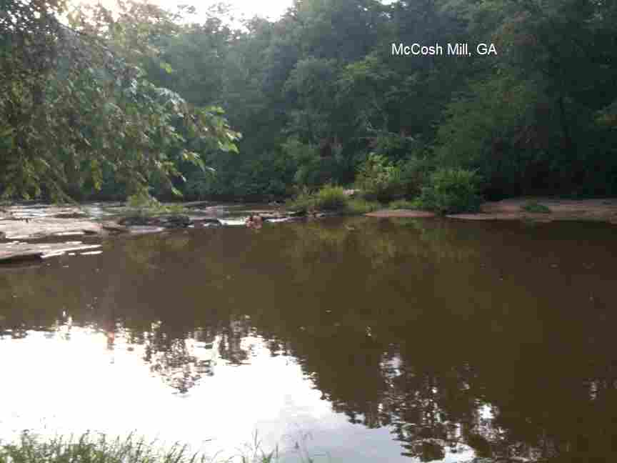
DESCRIPTION | Swimming place in creek near old mill ruins. Appears that it can be muddy sometimes - road may be muddy sometimes too, may have to park and walk to swimming hole. (This place is actually just over the border into AL but do not try to get there from the AL side!) |
|---|
|
AREAS | unknown |
|---|
|
SANCTION | Unofficial |
|---|
|
FEE | None |
|---|
|
FACILITIES |
None |
|---|
|
ACTIVITIES |
Swimming |
|---|
|
PHONE | None |
|---|
|
CAMPING | None at site |
|---|
|
BATHING SUITS | Unknown |
|---|
|
DIRECTIONS | From Lagrange, GA, go West on RT 109. After you cross over the bridge over West Point Lake thake the second road on the right (Rock Mills Rd.) then turn left on McCosh Mill Rd just before you get to the convenience store. Travel on this road until you reach the swimming hole. |
|---|
|
CONFIDENCE | Pretty confident |
|---|
|
VERIFIED BY WEBMASTER | no |
|---|
|
DATE UPDATED | 2/2011 |
|---|
|
|---|
This swimming hole listing is by
www.swimmingholes.org
MILL CREEK
(MILL)
|
|
TOWNS | ATLANTA, WOODSTOCK |
|---|
|
LAT, LON | lat=34.12229, lon=-84.49834(source: map)(accuracy: general area)
LINK TO GOOGLE |
|---|
|
STATE | GA |
|---|
|
WATER | Mill Creek |
|---|
|
TYPE | Creek |
|---|
| DESCRIPTION | Swimming hole with rope swing in Mill Creek in Woodstock. No better information. |
|---|
|
AREAS | Unknown |
|---|
|
SANCTION | Unofficial |
|---|
|
FEE | None |
|---|
|
FACILITIES |
Unknown |
|---|
|
ACTIVITIES |
Swimming, Rope swing |
|---|
|
PHONE | None |
|---|
|
CAMPING | None at site |
|---|
|
BATHING SUITS | Unknown |
|---|
|
DIRECTIONS | From Atlanta, take I-75 north then I-575 north and get off at the Woodstock exit and go east into Woodstock. Look at a map - Mill Creek is about 2 miles north of downtown Woodstock. Don't know where along here the swimming place is. There is a park called Olde Rope Mill Park at about where I-575 crosses Mill Creek, that might be a good place to start looking, though the Olde Rope Mill Park web site doesn't mention swimming. Please tell us if you find it.
|
|---|
|
CONFIDENCE | Very uncertain (as to directions) |
|---|
|
VERIFIED BY WEBMASTER | No |
|---|
|
DATE UPDATED | 12/2012 |
|---|
|
|---|
This swimming hole listing is by
www.swimmingholes.org
POOLES MILL
(POOL)
|
| TOWNS | ATLANTA, ALPHARETTA, CUMMING, HEARDSVILLE |
|---|
|
LAT, LON | lat=34.29097, lon= -84.24069(source: geocaching.com)(accuracy: approximate)
LINK TO GOOGLE |
|---|
|
STATE | GA |
|---|
|
WATER | Settingdown Creek |
|---|
|
TYPE | Creek |
|---|
|
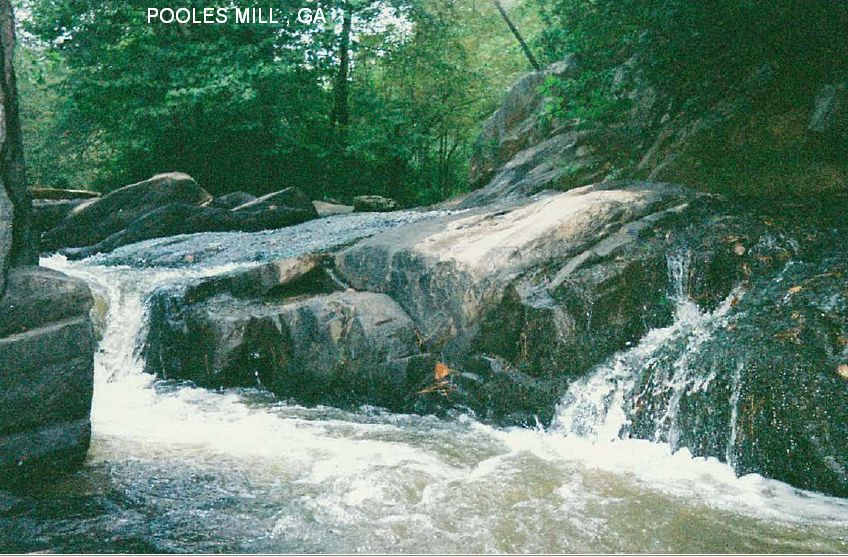
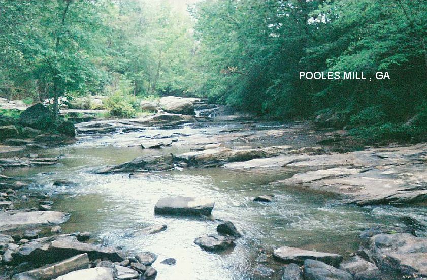
DESCRIPTION | From a fan:� There is a covered bridge, rope swing (hopefully still being replaced often), trails & water gushing over rocks. Pretty safe." [See also EDGE OF THE WORLD swimming hole, nearby.]
This from a visitor in 2008:"Directions where right on. Very disappointed in the location it self. There was a covered bridge but no rope swing. A ranger was on site and I felt swimming was discouraged. This would be a good place for young kids to wade around and splash in the water as there was a big section of the creek very close to the park that had some small spill way type water falls. No alcohol and a lot of it was posted. I would not go back"
|
|---|
|
AREAS | None |
|---|
|
SANCTION | Unofficial |
|---|
|
FEE | None |
|---|
|
FACILITIES |
None |
|---|
|
ACTIVITIES |
Swimming, Rope swing |
|---|
|
PHONE | None |
|---|
|
CAMPING | None at site |
|---|
|
BATHING SUITS | Unknown |
|---|
|
DIRECTIONS | From Atlanta, take RT 19 north many miles to Cumming, go 7 miles west on RT 20 to Ducktown, 3 miles north to Heardsville and 1 mile north on Poole's Mill Road. The swimming hole is near here. No better directions. |
|---|
|
CONFIDENCE | Pretty confident |
|---|
|
VERIFIED BY WEBMASTER | no |
|---|
|
DATE UPDATED | 10/01/2008 |
|---|
|
|---|
This swimming hole listing is by
www.swimmingholes.org
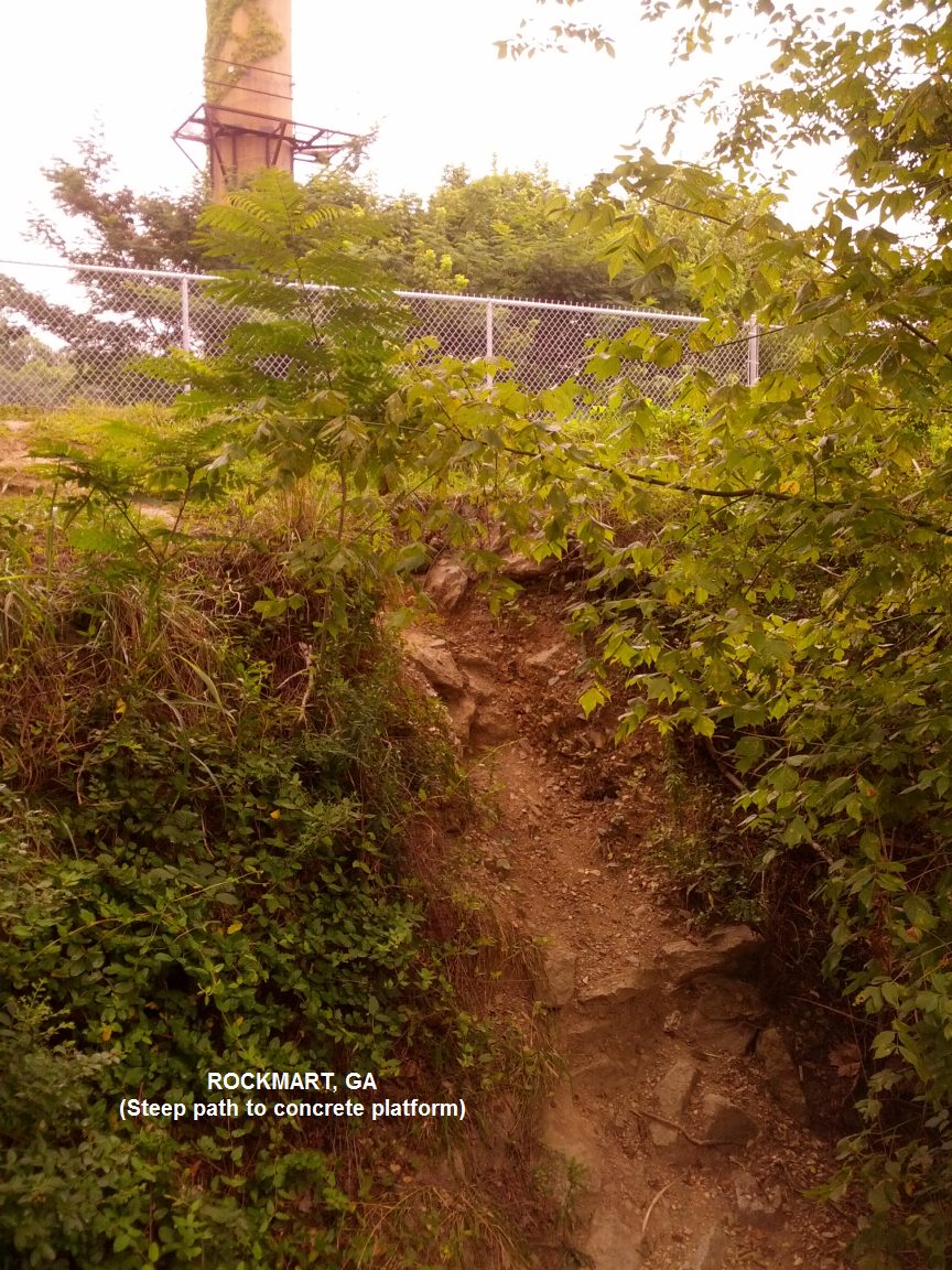
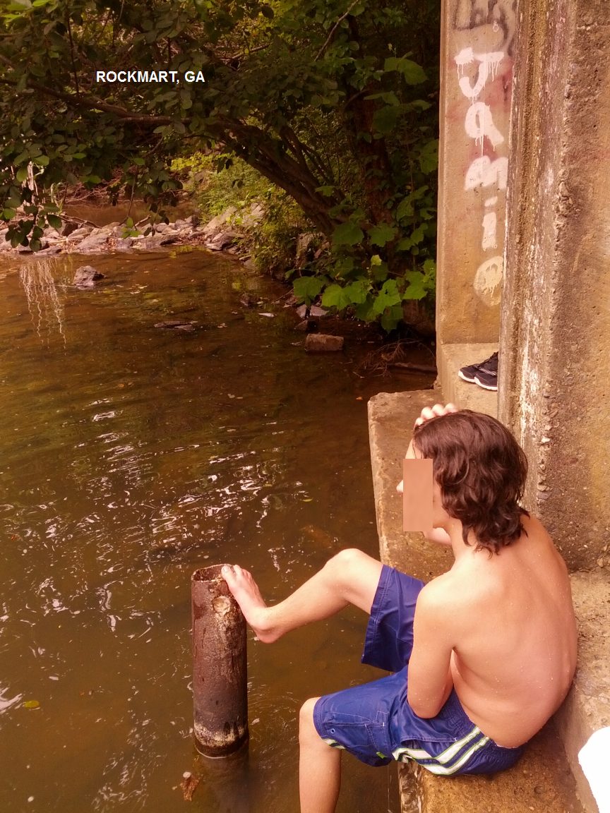
ROCKMART
(ROCK)
|
|
TOWNS | ATLANTA, DALLAS, ROCKMART |
|---|
|
LAT, LON | lat=33.9898, lon=-85.0531(source: Topozone)(accuracy: approximate)
LINK TO GOOGLE |
|---|
|
STATE | GA |
|---|
|
WATER | Thompson Creek |
|---|
|
TYPE | Creek |
|---|
| DESCRIPTION | A deep swimming hole in a creek near the Rockmart quarry in the town of Rockmart. You can jump off the concrete base of an old pump station into a dammed portion of Thompson Creek. It is on the new Silver Comet Trail , a paved hiking-biking trail over 37 miles long, starting at Mavell Rd. in Smyrna going to Water Street in historic downtown Rockmart. The swimming place is very near the Rockmart end of this trail, on the south side of the trail across from the quarry, marked only by a small path.
This report from a visitor in 7/2014:" We just visited this swimming hole and we were disappointed because it didn't seem safe to jump in such rocky, shallow water and there was a lot of erosion between the bank and where the huge cement platform started. We had to climb a very rocky and steep path to access the platform. Maybe when water levels are higher, this would be a nice spot to jump in. The platform itself is two levels and my son swam a bit off the lower level only. The directions were great and easy to follow. We parked in the little town and walked down the road to where the comet trail starts. You just turn left (upstream) and its only a little ways up the path. Was also disappointed at all the litter around the swimming hole but overall a fun adventure."
|
|---|
|
AREAS | None |
|---|
|
SANCTION | Unofficial |
|---|
|
FEE | None |
|---|
|
FACILITIES |
None |
|---|
|
ACTIVITIES |
Swimming, Jumping |
|---|
|
PHONE | None |
|---|
|
CAMPING | None at site |
|---|
|
BATHING SUITS | Sometimes optional |
|---|
|
DIRECTIONS | From Atlanta, take RT 278 northwest to town of Rockmart. In Rockmart, go south on Marble Street (one of the main streets) On the other side of "Historic Downtown Rockmart", Marble St. crosses the train tracks and then passes the entrance to the Silver Comet Trail and then over Thompson's Creek. Park near here (not exactly sure where to park) and walk upstream on the trail a short distance to where you will see a well-worn path angling down toward the creek. The main swimming hole is at the bottom of this short path. If you walk downstream on the path, there is a small dam and apparently kids swim here also depending on water level. |
|---|
|
CONFIDENCE | Very confident |
|---|
|
VERIFIED BY WEBMASTER | Yes, 4/03 |
|---|
|
DATE UPDATED | 7/2014 |
|---|
|
|---|
This swimming hole listing is by
www.swimmingholes.org
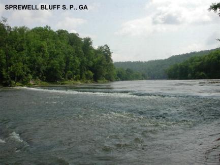
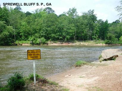
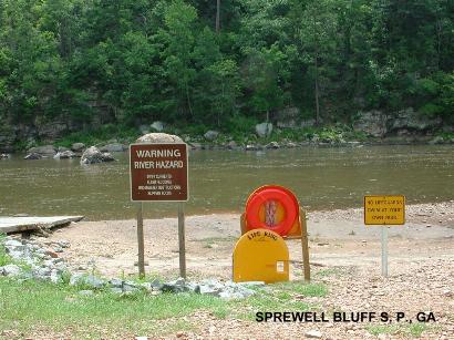
SPREWELL BLUFF S. P.
(SPRE)
|
|
TOWNS | ATLANTA, THOMASTON |
|---|
| LAT, LON | lat=32.85317, lon=-84.48000(source: DeLorme) (accuracy:exact)
LINK TO GOOGLE |
|---|
|
STATE | GA |
|---|
|
WATER | Flint River |
|---|
|
TYPE | River |
|---|
|
DESCRIPTION | Classic swimming holes; clear water, high jumping rock, lots of
trees all around.
|
|---|
|
AREAS | Sprewell Bluff S. P. |
|---|
|
SANCTION | Unofficial |
|---|
|
FEE | No |
|---|
|
FACILITIES |
Unknown |
|---|
|
ACTIVITIES |
Swimming, jumping (with care) |
|---|
|
PHONE | None |
|---|
|
CAMPING | Unknown |
|---|
|
BATHING SUITS | Unknown |
|---|
|
DIRECTIONS | From Atlanta go south on RT 19/41 bearing off right on RT 19 south of Griffin. Follow RT 19 south to Thomaston, turn right in Thomaston onto RT 74 west toward Woodbury. Go about 5 miles then turn left onto Old Alabama Rd.. Follow Old Alabama Road until you reach the entrance to the State Park. After entering the park, follow the road down to the Flint River. This road dead ends at the bluff in about 4 miles.
Possible swimming places (depending on river level) are: 1) right across from the boat launch where there are some rocks and 2) hike upstream on the trail and at the far end (upstream) of the day use area there is a sandy shore to swim and some rocks for sunning. Don't jump from the rocks as it is too shallow. There did appear to be a deep pool further from shore. 3) at the Natural Dam, which you can reach by following the trail upstream for about 1.5 miles. |
|---|
|
CONFIDENCE | Very confident |
|---|
|
VERIFIED BY WEBMASTER | By Dave Hajdasz |
|---|
|
DATE UPDATED | 12/26/2001 |
|---|
|
|---|
This swimming hole listing is by
www.swimmingholes.org
SWEETWATER CREEK S. P.
(SWEE)
|
|
TOWNS | ATLANTA, LITHIA SPRINGS |
|---|
|
LAT, LON | lat=33.75386, lon=-84.62753(source: measured)(accuracy: exact)
LINK TO GOOGLE |
|---|
|
STATE | GA |
|---|
|
WATER | Sweetwater Creek |
|---|
|
TYPE | Creek |
|---|
|
DESCRIPTION | A beautifully wooded State Park with lots of hiking, Sweetwater Creek is a large creek with significant rapids and places for water play and wading - not really a swimming place (swimming is prohibited here.). The best areas for water play and wading are near and downstream of the old mill ruins. SWEETWATER CREEK S. P. WEB SITE . |
|---|
|
AREAS | Sweetwater Creek S. P. |
|---|
|
SANCTION | Unofficial (swimming is prohibited) |
|---|
|
FEE | $2.00 per car |
|---|
|
FACILITIES |
Picnic, Toilets, Rental boats |
|---|
|
ACTIVITIES |
Wading |
|---|
|
PHONE | Unknown |
|---|
|
CAMPING | None at the site |
|---|
|
BATHING SUITS | Customary |
|---|
|
DIRECTIONS | From Atlanta: Take I-20 west, exit #44 at Thornton RD, turn left and go .25 mile, follow signs to park. (Turn right on Blairs Bridge RD, go 2 miles and turn left on Mount Vernon Road.) When you get to the park and large lake, go past several entrances, following signs to the park office and "Sweetwater Creek", turning left on Factory Shoals Rd.. Park and hike about .5 miles to the old factory ruins. The best water play places are in the rapids above and below the old factory.
|
|---|
|
CONFIDENCE | Very confident |
|---|
|
VERIFIED BY WEBMASTER | Yes, 2/04 |
|---|
|
DATE UPDATED | 2/28/2004 |
|---|
|
|---|
This swimming hole listing is by
www.swimmingholes.org
WATSON MILL BRIDGE S. P.
(WATS)
|
|
TOWNS | ATLANTA, ATHENS, COMER |
|---|
|
LAT, LON | lat=34.025, lon=-83.074983(source: web site)(accuracy: approximate)
LINK TO GOOGLE |
|---|
|
STATE | GA |
|---|
|
WATER | South Fork River |
|---|
|
TYPE | River |
|---|
|
DESCRIPTION | Water play place in the river shoals near the longest covered bridge in the state, spanning 229 feet across the South Fork River. web site. |
|---|
|
AREAS | Watson Mill Bridge S. P. |
|---|
|
SANCTION | Unofficial |
|---|
|
FEE | unknown |
|---|
|
FACILITIES |
All facilities |
|---|
|
ACTIVITIES |
Wading, water play |
|---|
|
PHONE | 706-783-5349 |
|---|
|
CAMPING | At the site |
|---|
|
BATHING SUITS | Required |
|---|
|
DIRECTIONS | From Atlanta: Take I-85 east to exit 147 then RT 98 (Maysville Rd) south to Comer then RT 22 south for 3 miles to signs for the State Park. Covered bridge has 9-foot maximum clearance. Equestrian campers need to use the park entrance off Hwy. 72 in Cartlon, while traditional campers may use the park entrance off Hwy. 22 in Comer.
|
|---|
|
CONFIDENCE | Very confident |
|---|
|
VERIFIED BY WEBMASTER | No |
|---|
|
DATE UPDATED | 2/2011 |
|---|
|
|---|
This swimming hole listing is by
www.swimmingholes.org
YELLOW RIVER PARK
(YELL)
|
|
TOWNS | ATLANTA, STONE MOUNTAIN, SNELLVILLE |
|---|
|
LAT, LON | lat=33.78760, lon=-84.07798(source: map)(accuracy: approximate)
LINK TO GOOGLE |
|---|
|
STATE | GA |
|---|
|
WATER | Yellow River |
|---|
|
TYPE | River |
|---|
|
DESCRIPTION | CAUTION: This river may be very polluted and swimming is not advised or permitted. It is a nice park with lots of trails and biking paths. Two good places to wade in the river (swimming is not permitted here and it is enforced). (1) From the main parking area at playground follow short trail southeast to observation deck and climb down to river. (2) Better spot: park in the far end of the parking lot away from the playground. Head north, away from playground on paved trail and you'll come to a sandy area right next to river. |
|---|
|
AREAS | Yellow River County Park |
|---|
|
SANCTION | Unofficial |
|---|
|
FEE | none |
|---|
|
FACILITIES |
Restrooms and water fountain at the playground |
|---|
|
ACTIVITIES |
Wading |
|---|
|
PHONE | 770.978.5270 |
|---|
|
CAMPING | None at the site |
|---|
|
BATHING SUITS | Required |
|---|
|
DIRECTIONS | From Atlanta: I-285 is the perimeter highway around Atlanta. Travel on I-285 to the eastern side of the city, and take Exit 39B to RT 78 east of the city. Travel about 9 miles to a light at the intersection of RT 78 and Rockbridge Road. Turn right at the light onto Rockbridge Road, which will turn into Annistown Road in about a mile. Continue on Annistown Road another half mile to mile and look for a small side street on the right called Juhan Road (there is a small green sign indicating the park). The turn for Juhan Road is right after you pass a lake and right before you cross over the Yellow River on a bridge. Once on Juhan Road continue straight for a mile and the park is on your left.
|
|---|
|
CONFIDENCE | Pretty confident |
|---|
|
VERIFIED BY WEBMASTER | By another |
|---|
|
DATE UPDATED | 6/2011 |
|---|
|
|---|
HOME
|
