See a SLIDESHOW of swimming hole photos in this state.
This swimming hole listing is by
www.swimmingholes.org
BANKS LAKE AREA
[3 PLACES]
(BANL)
|
|
TOWNS | WENATCHEE, COULEE CITY, ELECTRIC CITY |
|---|
|
STATE | WA |
|---|
|
WATER | Banks Lake |
|---|
|
TYPE | Lake |
|---|
|
DESCRIPTION | Several informal swimming places in Banks Lake north of Coulee City which is east of Wenatchee. See DIRECTIONS below for details.
|
|---|
|
AREA | Steamboat Rock S. P. |
|---|
|
SANCTION | Unofficial |
|---|
|
FEE | None |
|---|
|
FACILITIES |
Full facilities nearby at state park |
|---|
|
ACTIVITIES |
Swimming |
|---|
|
PHONE | None |
|---|
|
CAMPING | At Steamboat Rock S. P. |
|---|
|
BATHING SUITS | Optional |
|---|
|
DIRECTIONS | From Wenatchee, take RT 97 north then RT 2 east (right) to Coulee City at the south end of Lake Banks, then:
COULEE BOULEVARD [COUL]: This from a fan:"Nice lakeside crescent sandy beach cove perfect for primitive camping and swimming in the deep cool lake. Expect more boaters than cars accessing this spot. Clothing optional is the norm here and there is plenty of room for everybody. To get here from Coulee City, go north on RT 155 for about 8.3 miles, look for an unmarked gravel road on the left about half way up the hioll as the highway starts a steep climb. If the road is not gated, proceed down to the lakeside camping spot and beach access. Otherwise park near the gate and hike down the 100yd road. Though it is next to the highway, it is out of view because of the cliffs as the road climbs high above the lake." LAT, LON lat=47.72399, lon=-119.25418(source: measured by another) (accuracy: approximate) LINK TO GOOGLE MAP. Very confident. Verified by another. Updated 1/2014.
STEAMBOAT ROCK S. P. [STEA]: This from a fan:"A great popular desert hike in or boat in only swimming spot in a secluded cove of Banks Lake with large jumping rocks into deep cold water. Watch for Rattlesnakes and exercise appropriate safety practices when jumping. Bathing Suits are the norm here but it is a great spot to skinny dip with discretion on weekdays. Please be respectful of others and pack out your trash. Enjoy. To get here, continue north on RT 155, go 8.6 miles past from the entrance to Steamboat Rock State Park (or 3.8 miles south of Electric City) and see a wide spot in RT 155 to park. Park and hike up and over the hillside and follow the trail down to the lake and the many options from swimming to high rock jumping." LAT, LON lat=47.88633, lon=-119.09066(source: measured by another) (accuracy: approximate) LINK TO GOOGLE MAP. Very confident. Verified by another. Updated 1/2014.
DEEP LAKE [DEEL]: This from a fan:" Popular kayaking, rock jumping and swimming in a deep cool lake in the desert in Sun Lakes State Park. To get here from Coulee City, go south on RT 17 to the entrance to Sun Lakes Dry Falls State Park Campground. Park fees or Discover Pass will apply. Follow the entrance road all the way down to the lake and proceed past the campground entrance and towards the day use area. Take a left onto State Park Rd. and follow it about 1 mile to the parking/boat launch area on Deep Lake. The jumping rocks are located along the West side of the lake just past the boat launch. Bathing suits necessary here. Enjoy." LAT, LON lat= 47.58802, lon=-119.34131(source: measured by another) (accuracy: approximate) LINK TO GOOGLE MAP. Very confident. Verified by another. Updated 1/2014.
|
|---|
|
CONFIDENCE | Very confident |
|---|
|
VERIFIED | No |
|---|
|
DATE UPDATED | 1/2014 |
|---|
|
|---|
This swimming hole listing is by
www.swimmingholes.org
BATTLE GROUND AREA
[5 PLACES]
(BATT)
|
|
TOWNS | PORTLAND(OR), VANCOUVER(WA), BATTLE GROUND (WA) |
|---|
|
LAT, LON | lat=45.8211, lon=-122.4518(source: DeLorme) (accuracy:general area)
LINK TO GOOGLE MAP |
|---|
|
STATE | WA |
|---|
|
WATER | Varies -see below |
|---|
|
TYPE | River/Falls |
|---|
|
DESCRIPTION | Several swimming places,some offical some not, on the East Fork of the Lewis River and other rivers near Battle Ground, which is just northeast of Vancouver, WA. See DIRECTIONS below for details.
|
|---|
|
AREA | County Parks and Gifford Pinchot N. F. |
|---|
|
SANCTION | Varies |
|---|
|
FEE | Unknown |
|---|
|
FACILITIES |
Full facilities at county parks |
|---|
|
ACTIVITIES |
Swimming, Jumping |
|---|
|
PHONE | unknown |
|---|
|
CAMPING | Unknown |
|---|
|
BATHING SUITS | Varies -see below |
|---|
|
DIRECTIONS | In Vancouver (WA) from I-205, take exit 30 then RT 500 north. Where RT 500 turns east (right) keep straight onto RT 503. Follow RT 503 north though Union, Bush Prairie and Battle Ground. Then:
DAYBREAK COUNTY PARK [DAYB]: Official swimming place in East Fork of the Lewis River in county park. Bathing suits for sure. Other facilities, fee unknown. To get here from RT 503 in Battle Ground, turn west (left) on RT 502 (W. Main St) then turn north (right) on NE 92nd Ave. Continue onto NE Manley Rd then turn north (right) on NE 82 Ave and continue to Daybreak Park. Park Web Site LAT, LON lat=45.81397, lon=-122.58759(source: map) (accuracy: approximate) LINK TO GOOGLE MAP. Very confident. Not verified. Updated 4/2011.
LEWISVILLE COUNTY PARK [LEWI]: Official swimming place in East Fork of the Lewis River in county park. Bathing suits for sure. Other facilities, fee unknown. To get here, continue north on RT 503 past Battle Ground and see signs for park. Swimming place is in river in park. Park Web Site LAT, LON lat=45.82044, lon=-122.53519(source: DeLorme) (accuracy: approximate) LINK TO GOOGLE MAP. Pretty confident. Not verified. Updated 2/2/2007.
MOULTON FALLS COUNTY PARK [MOUL]: Great swimming place in East Fork of the Lewis River in county park. YOUTUBE. Bathing suits for sure. Other facilities, fee unknown. To get here, continue north on RT 503 past Lewisville County Park (above) and turn east (right) onto NE Rock Creek Rd (if you get to Fargher Lake you have gone too far), then continue onto NE 152nd south then onto NE Lucia Falls Rd. east. Follow Lucia Falls Rd past Lucia Falls (don't know about swimming there) to Moulton Falls County Park and see signs for park. Swimming place is in river in park. LAT, LON lat=45.83148, lon=-122.38910(source: DeLorme) (accuracy: approximate) LINK TO GOOGLE MAP. Pretty confident. Not verified. Updated 2/2/2007.
SUNSET FALLS [SUNS]: Unofficial swimming place at foot of falls in Gifford Pincot N. F.. Apparently some jumping and sliding also - CHECK DEPTH AND CURRENTS BEFORE JUMPING! Other facilities, fee unknown. To get here, just past Moulton Falls park turn east (right) on NE Sunset Falls Rd.. Continue on this road past Horseshoe Falls (don't know about swimming there)into the National Forest to Sunset Falls Recreation Area right near the National Forest boundary. Swimming place is at bottom of falls. LAT, LON lat=45.8189, lon=-122.2531(source: DeLorme) (accuracy: approximate) LINK TO GOOGLE MAP. Pretty confident. Not verified. Updated 2/2/2007.
SIOUXON CREEK [SIOU]: Trail along beautiful creek with waterfalls and swimming holes. YOUTUBE. Excellent for running and mountain biking too. Places to (primitive) camp along the trail beginning about 1/2 mile in. May get a glimpse of (what's left of) Mt. Saint Helens if you hike in far enough. Some steep switchbacks if you hike far in and some bugs and crowds in summer - spring may be best. Described by one visitor as:"... a bit like spending the day at an outdoors-themed fun park. Amazing experience."
To get here, continue north from Lewisille County Park (above) on RT 503, go past Amboy to the small town of Chelatchie then and turn east (right) on NE Healy road. Follow this road as it turns several times for about 9 miles total, then turn left on National Forest Rd. 57 Go about 1 mile, then turn left on National Forest Rd. 5701. Continue on this paved road about 4+ miles to the trailhead. Hike, swim, camp and enjoy! LAT, LON of trailhead: lat=45.94618, lon=-122.17826(source: web site) (accuracy: approximate) LINK TO GOOGLE MAP. Pretty confident. Not verified. Updated 12/2008.
|
|---|
|
CONFIDENCE | Pretty confident |
|---|
|
VERIFIED | No |
|---|
|
DATE UPDATED | 12/2008 |
|---|
|
|---|
This swimming hole listing is by
www.swimmingholes.org
COWLITZ RIVER
(COWL)
|
|
TOWNS | RANDLE, YAKIMA, PACKWOOD |
|---|
|
LAT, LON | lat=46.66434, lon=-121.60037(source: measured by another) (accuracy: approximate)
LINK TO GOOGLE MAP |
|---|
|
STATE | WA |
|---|
|
WATER | Cowlitz River |
|---|
|
TYPE | River |
|---|
|
DESCRIPTION | This from a fan:"Great swimming hole where the NF Rd. 1270 bridge used to cross the Cowlitz River near Mt. Rainier National Park. This spot is very secluded and only known to locals...so skinny dipping is very possible and happens. Lots of room to camp, kayak and hike also. The river is wide, deep and slow here - after spring run-off is over, of course. Enjoy!"
|
|---|
|
AREA | Gifford Pinchot N. F./Mt. Rainier National Park |
|---|
|
SANCTION | Unofficial |
|---|
|
FEE | None |
|---|
|
FACILITIES |
None at site |
|---|
|
ACTIVITIES |
Swimming |
|---|
|
PHONE | None |
|---|
|
CAMPING | Several campgrounds nearby in Gifford Pinchot N. F./Mt. Rainier National Park |
|---|
|
BATHING SUITS | Optional |
|---|
|
DIRECTIONS | This from a fan: "From I-5 (south of Olympia) take Exit 68 and go east on RT 12 for many miles to Packwood, in Mt. Rainier National Park. Continue on RT 12 east towards White Pass. At about 5 miles east of Packwood, take a turn off to the north (left) onto NF RT 1270. The road is gated at the river because the bridge is out so park and hike down 1/2 mile to the river's edge and the large swimming hole." |
|---|
|
CONFIDENCE | Very confident |
|---|
|
VERIFIED | By another |
|---|
|
DATE UPDATED | 1/2014 |
|---|
|
|---|
This swimming hole listing is by
www.swimmingholes.org
DASH POINT BEACH
(DASB)
|
|
TOWNS | TACOMA, FEDERAL WAY |
|---|
|
LAT, LON | lat=47.32102, lon=-122.4076(source: map) (accuracy: approximate)
LINK TO GOOGLE MAP |
|---|
|
STATE | WA |
|---|
|
WATER | Puget Sound |
|---|
|
TYPE | Sound |
|---|
|
DESCRIPTION | Dash Point State Park beach, entry fee, relatively warm water and sun, best in the afternoon. Restroom, outdoor shower. Camping at the site. WEB SITE . |
|---|
|
AREA | Dash Point State Park |
|---|
|
SANCTION | Official |
|---|
|
FEE | Yes |
|---|
|
FACILITIES |
All facilties at site |
|---|
|
ACTIVITIES |
Swimming |
|---|
|
PHONE | Unknown |
|---|
|
CAMPING | Camping in the State Park. |
|---|
|
BATHING SUITS | Required |
|---|
|
DIRECTIONS |
DIRECTIONS: From Tacoma, take I-5 north to Exit 143 then take S 320th St. (turns into SW 320th St.) west all the way to the end of the street at Dash Point S. P.. Address: 5700 S.W. Dash Point Road, Federal Way |
|---|
|
CONFIDENCE | Very confident |
|---|
|
VERIFIED | By another |
|---|
|
DATE UPDATED | 1/2014 |
|---|
|
|---|
This swimming hole listing is by
www.swimmingholes.org
DOUGLAS CREEK
(DOUG)
|
|
TOWNS | YAKIMA, WENATCHEE, WATERVILLE |
|---|
|
LAT, LON | lat=47.46245, lon=-119.87320(source: map) (accuracy: general area)
LINK TO GOOGLE MAP |
|---|
|
STATE | WA |
|---|
|
WATER | Douglas Creek (perennial) |
|---|
|
TYPE | Creek/waterfalls |
|---|
|
DESCRIPTION | From the BLM web site: "Visitors are drawn to scenic Douglas Creek canyon for its hunting, fishing, hiking, and dispersed camping experiences, as well as swimming in the deep pools and waterfalls at its south end. A great variety of plants, animals and birds make their homes in or near the lush oasis created by this year-round stream." LINK TO INFO |
|---|
|
AREA | BLM Spokane District |
|---|
|
SANCTION | Unofficial |
|---|
|
FEE | None |
|---|
|
FACILITIES |
Unknown |
|---|
|
ACTIVITIES |
Swimming, hiking, fishing |
|---|
|
PHONE | 509-536-1200 (BLM office) |
|---|
|
CAMPING | Primitive dispersed camping in the canyon. Developed camping at Daroga State Park north of Orondo on RT 2/97. |
|---|
|
BATHING SUITS | Unknown |
|---|
|
DIRECTIONS | From Wenatchee take RT 28 south about 16 miles then turn northeast (left) onto Palisades Rd and go about 14.7 miles then take a left onto Moses Coulee Rd.. As the road curves right, stay straight until the T in the Rd. Then make a left onto Slack Canyon Rd. WARNING: You may have to park at the wideout just before the first creek crossing and hike/bike in if the creek is too high over the road for your vehicle. Follow the gravel road for 1.7 miles to the parking areas above the Creek. Hike down the well used trails and find a spot to enjoy. Explore up and down stream for many other great spots.
|
|---|
|
CONFIDENCE | Very confident |
|---|
|
VERIFIED | By another |
|---|
|
DATE UPDATED | 1/2014 |
|---|
|
|---|
This swimming hole listing is by
www.swimmingholes.org
EATONVILLE AREA
[2 PLACES]
(EATA)
|
|
TOWNS | TAKOMA, OLYMPIA, EATONVILLE, MORTON |
|---|
|
STATE | WA |
|---|
|
WATER | Varies - see below |
|---|
|
TYPE | River pools |
|---|
|
DESCRIPTION | In Eatonville's |
|---|
|
AREA | Varies - see below |
|---|
|
SANCTION | Unofficial |
|---|
|
FEE | Unknown |
|---|
|
FACILITIES |
Unknown |
|---|
|
ACTIVITIES |
Swimming, Jumping, Wading |
|---|
|
PHONE | Unknown |
|---|
|
CAMPING | No camping at sites. |
|---|
|
BATHING SUITS | Required |
|---|
|
DIRECTIONS | From Takoma, take I-5 south for 6 miles then take exit 127 for RT 512 E toward Puyallup then turn left onto RT 512 east for 2 miles then take the RT 7/Pacific Ave exit toward Parkland/Spanaway. Continue on RT 7 for about 16 miles then turn left onto 352nd St E/Golden Rd/Labor Devore Rd right onto Eatonville Cutoff Rd E for about 5 miles then turn right onto RT 161 S/Meridian Ave E into Eatonville. Then:
SMALLWOOD PARK [SMAL]: In Eatonville's Smallwood Park, the Mashel River has lots of pools made by rocks and logjams. Sunning, swimming and jumping. Shallow areas for little ones. From Eatonville, go south on Mashel Ave. and turn left into Smallwood Park just after the Mashel River bridge. From the far parking lot, veer left to the sign, park and climb down the rocks to the bank. LAT, LON: lat=46.85978, lon=-122.26052(source: map) (accuracy: approximate) LINK TO GOOGLE MAP. Very confident. Not verified. Updated 1/2013.
TILTON RIVER BRIDGE [TILT]: In Morton, there is an in-town swimming hole in the Tilton River under a highway brodge. YOUTUBE. LAT, LON: lat=46.56057, lon=-122.28526(source: map) (accuracy: approximate) LINK TO GOOGLE MAP. From Eatonville (above) go south on Mashell Ave S and take the 1st left onto Center St E then continue onto Alder Cutoff Rd E and go about 6.5 miles. Then turn left onto RT 7 S/Mountain Hwy E/National Park Hwy and go 5 miles then turn right onto RT 7 S and go about 16.5 miles then turn right onto RT 508 W and go to the bridge over the Tilton River. The swimming holes is near this bridge.
Uncertain as to location. Not verified. Updated 1/2013.
|
|---|
|
CONFIDENCE | Varies |
|---|
|
VERIFIED | No |
|---|
|
DATE UPDATED | 1/2013 |
|---|
|
|---|
This swimming hole listing is by
www.swimmingholes.org
FRENCH CABIN CREEK
(FREN)
|
|
TOWNS | ELLENSBURG, CLE ELUM |
|---|
|
LAT, LON | lat=47.35671, lon=-121.11235(source: map) (accuracy: approximate)
LINK TO GOOGLE MAP |
|---|
|
STATE | WA |
|---|
|
WATER | French Cabin Creek |
|---|
|
TYPE | Creek |
|---|
|
DESCRIPTION | Two swimming places in a cold, clear National Forest creek on either side of a bridge. |
|---|
|
AREA | Wenatchee National Forest |
|---|
|
SANCTION | Unofficial |
|---|
|
FEE | None |
|---|
|
FACILITIES |
There are pit toilets at the first bridge - over the Cle Elum river. |
|---|
|
ACTIVITIES |
Swimming |
|---|
|
PHONE | None |
|---|
|
CAMPING | Cle Elum River N.F. campground is nearby on Salmon La Sac Rd. |
|---|
|
BATHING SUITS | May be optional |
|---|
|
DIRECTIONS | From I-90, take the Cle Elum/Roslyn exit 84 and head north on RT 903, (past Roslyn) and go about 10 miles (RT 903 becomes Salmon La Sac Rd.). You will pass Cle Elum lake on the left then you will come to French Cabin Creek rd (dirt) on the left (NF 4308). Turn left follow the dirt road over the Cle Elum river and up the hill about .25 mile till you come to a rickety bridge. There's a parking area just past the bridge. Then trails that lead to two different swimming holes one on the left and right of the bridge.
|
|---|
|
CONFIDENCE | Pretty confident |
|---|
|
VERIFIED | No |
|---|
|
DATE UPDATED | 9/2014 |
|---|
|
|---|
This swimming hole listing is by
www.swimmingholes.org
GREEN RIVER AREA
[3 PLACES]
(GREA)
|
|
TOWNS | SEATTLE, NORTH BEND |
|---|
|
STATE | WA |
|---|
|
WATER | Upper Green River |
|---|
|
TYPE | River |
|---|
|
DESCRIPTION | Several informal swimming places in Upper Green River east of Seattle and North Bend. See DIRECTIONS below for details.
|
|---|
|
AREA | Wenatchee N.F. |
|---|
|
SANCTION | Unofficial |
|---|
|
FEE | None |
|---|
|
FACILITIES |
None at sites |
|---|
|
ACTIVITIES |
Swimming |
|---|
|
PHONE | None |
|---|
|
CAMPING | At Lake Easton S. P. on I-90 |
|---|
|
BATHING SUITS | Optional |
|---|
|
DIRECTIONS | From I-90 east of Seattle, near North Bend, take exit 62 (Kachess Lake Rd.) and go West onto NF 54 and go over the Yakima River and continue for 13.2 miles (later mostly weaving around & under the power lines and along Sunday Creek). Keep left at any slight "Y" in the road which is now NF-5400-1. At the "T" meeting NF-5200, turn right on NF-5400-2. Then:
LESTER CREEK [LEST]: This from a fan:"A nice sandy river side camping, sunning and large swimming hole on the upper Green River with lots of room to explore upriver. From the junction of NF-5200 and NF-5400-2 (above), follow NF-5400-2 for 1.6 miles. Take a left down to the river, park next to the river and hike downstream to the beach & swimming hole below the small trestle and enjoy." LAT, LON lat=47.20988, lon=-121.48124(source: measured by another) (accuracy: approximate) LINK TO GOOGLE MAP. Very confident. Verified by another. Updated 1/2014.
TRESTLE [TRES]: This from a fan:"A nice river side camping, sunning and swimming area on the upper Green River across the train tracks and below the trestle. Bathing suits unnecessary even though there is frequent freight train traffic. To get here from the junction of NF-5200 and NF-5400-2 (above), follow NF-5400-2 for 3 miles. (In 2 miles it becomes NF-5400-3). Turn Left down the road following under the power line to the RR tracks and park well away from the tracks. Carefully walk across the tracks and go down to the beach and swimming hole near the trestle and enjoy." LAT, LON lat=47.20553, lon=-121.51338(source: measured by another) (accuracy: approximate) LINK TO GOOGLE MAP. Very confident. Verified by another. Updated 1/2014.
|
|---|
|
CONFIDENCE | Very confident |
|---|
|
VERIFIED | No |
|---|
|
DATE UPDATED | 1/2014 |
|---|
|
|---|
This swimming hole listing is by
www.swimmingholes.org
LOWELL JOHNSON PARK
(LOWL)
|
|
TOWNS | TACOMA, LAKEWOOD, STEILACOOM, ANDERSON ISLAND |
|---|
|
LAT, LON | lat=47.16865, lon=-122.69021(source: map) (accuracy: approximate)
LINK TO GOOGLE MAP |
|---|
|
STATE | WA |
|---|
|
WATER | Florence Lake (Columbia River) |
|---|
|
TYPE | Lake |
|---|
|
DESCRIPTION | Small lake beach with fun for all ages and abilities.
No lifeguards. |
|---|
|
AREA | Lowell Johnson Park, 114th Ave and Guthrie Rd, Anderson Island
|
|---|
|
SANCTION | Unofficial |
|---|
|
FEE | None |
|---|
|
FACILITIES |
Restrooms, changing areas, picnic tables. There is no food or drinking water available at the park. |
|---|
|
ACTIVITIES |
Swimming |
|---|
|
PHONE | None |
|---|
|
CAMPING | None at site |
|---|
|
BATHING SUITS | Required |
|---|
|
DIRECTIONS |
DIRECTIONS: Take the ferry from Steilacoom (southwest of Tacoma) to Anderson Island. You can take your car or bike on the ferry, but it is a steep hill for biking up to the lake. From the ferry landing, take Yoman Rd. then left on Harbor Place NW then right on Guthrie Rd. then left into Lowell Johnson Park. |
|---|
|
CONFIDENCE | Very confident |
|---|
|
VERIFIED | By another |
|---|
|
DATE UPDATED | 1/2014 |
|---|
|
|---|
This swimming hole listing is by
www.swimmingholes.org
OLYMPIC HOT SPRINGS
(OLYM)
|
|
TOWNS | SEATTLE, PORT ANGELES |
|---|
|
LAT, LON | lat=47.976, lon=-123.688(source: web site) (accuracy:approximate)
LINK TO GOOGLE MAP |
|---|
|
STATE | WA |
|---|
|
WATER | Olympic Hot Springs |
|---|
|
TYPE | Hot Springs |
|---|
|
DESCRIPTION | Outstanding and deservedly famous, series of 6+ all natural, rock-lined hot springs pools in Olympic N.P.. Take a small piece of rug to sit on. INFO AND PHOTOS , VERY INFORMATIVE VIDEO . A 2.5 mile beautiful hike each way in summer, longer in winter as they close the road further down. May have to ford a creek or two on the trail. |
|---|
|
AREA | Olympic N. P. |
|---|
|
SANCTION | Unofficial |
|---|
|
FEE | None |
|---|
|
FACILITIES |
None |
|---|
|
ACTIVITIES |
Hot Tubbing |
|---|
|
PHONE | Unknown |
|---|
|
CAMPING | Primitive (backpacking) camping near the pools. Developed camping at Elwha Campground. |
|---|
|
BATHING SUITS | Optional (mostly none) |
|---|
|
DIRECTIONS | From Port Angeles take RT 101 west approximately 8 miles to Olympic Hot Springs Road. Turn south (left) and continue into Olympic N.P.. In about 3 miles from RT 101 pass Elwha Campground and continue past campground to the Elwha Ranger Station. Past the ranger station go right where Whiskey Bend Road goes left. Follow this road 6 miles to its end and the trailhead for Boulder Creek (NOTE: as of 11/2014, this road is repaired and now driveable to the trailhead). Park and hike along the (closed) road for 2 miles to a side trail to the left that goes 1/2 miles to Olympic Hot Springs. The trail has 3 water crossings in total - some may be wet fords.
|
|---|
|
CONFIDENCE | Very confident |
|---|
|
VERIFIED | Yes |
|---|
|
DATE UPDATED | 12/2008 |
|---|
|
|---|
This swimming hole listing is by
www.swimmingholes.org
QUARRY POOL
(QUAR)
|
|
TOWNS | OLYMPIA, TENINO |
|---|
|
LAT, LON | lat=46.85589, lon=-122.85172(source: map) (accuracy: approximate)
LINK TO GOOGLE MAP |
|---|
|
STATE | WA |
|---|
|
WATER | Squire Creek |
|---|
|
TYPE | Creek |
|---|
|
DESCRIPTION | City park with official swimming in an unused quarry. Deep, dark, cold (spring-fed) water. Waterfall, kiddie pool. Diving boards. Kiddie pool. Entry fee. WEB SITE |
|---|
|
AREA | Tenino City Park |
|---|
|
SANCTION | Official |
|---|
|
FEE | Small fee is charged |
|---|
|
FACILITIES |
All facilities, picnic, playground |
|---|
| ACTIVITIES |
Swimming, picnicing |
|---|
|
PHONE | (360)264-2368 |
|---|
|
CAMPING | None at site. |
|---|
|
BATHING SUITS | Required |
|---|
|
DIRECTIONS | From Olympia, take I-5 south to Exit 102, and turn left onto Trosper Road then turn right onto Capitol Boulevard. Continue straight onto Old Highway 99. At Tenino turn right onto East Sussex Street, left on Olympia Street and continue to the City Park. Address: City Park, 100 Howard St. N, Tenino. |
|---|
|
CONFIDENCE | Very confident |
|---|
|
VERIFIED | No |
|---|
|
DATE UPDATED | 1/2013 |
|---|
|
|---|
This swimming hole listing is by
www.swimmingholes.org
RAINBOW FALLS S. P.
(RAIN)
|
|
TOWNS | TACOMA, OLYMPIA, CHEHALIS, DOTY |
|---|
|
LAT, LON | lat=46.63117, lon=-123.23431(source: DeLorme) (accuracy:exact)
LINK TO GOOGLE MAP|
STATE | WA |
|---|
|
WATER | Chehalis River |
|---|
|
TYPE | River |
|---|
|
DESCRIPTION | Small waterfall but with a nice swimming hole at the bottom. I think this is an official swimming place in the state park. RAINBOW FALLS S. P. .
|
|---|
|
AREA | Rainbow Falls S.P. |
|---|
|
SANCTION | Official? |
|---|
|
FEE | Unknown |
|---|
|
FACILITIES |
All facilities |
|---|
|
ACTIVITIES |
Swimming |
|---|
|
PHONE | (360) 291-3767 |
|---|
|
CAMPING | At site |
|---|
|
BATHING SUITS | Required |
|---|
|
DIRECTIONS | from Tacoma/Olympia, take I-5 south to Chehalis. Take exit 77 onto RT 6. Head west in the direction of Raymond for 16 miles - follow signs to park.
|
|---|
|
CONFIDENCE | Very confident |
|---|
|
VERIFIED | No |
|---|
|
DATE UPDATED | 11/6/2005 |
|---|
|
|---|
|
|---|
This swimming hole listing is by
www.swimmingholes.org
RAINIER EAST AREA
[4 PLACES]
(RANE)
|
|
TOWNS | YAKIMA |
|---|
|
STATE | WA |
|---|
|
WATER | Little Naches River |
|---|
|
TYPE | River |
|---|
|
DESCRIPTION | Several informal swimming places in Little Naches River northwest of Yakima. See DIRECTIONS below for details.
|
|---|
|
AREA | Wenatchee N.F. |
|---|
|
SANCTION | Unofficial |
|---|
|
FEE | None |
|---|
|
FACILITIES |
Full facilities at Longmire Meadow Campground |
|---|
|
ACTIVITIES |
Swimming |
|---|
|
PHONE | None |
|---|
|
CAMPING | At Little Naches Campground and Longmire Meadow Campground |
|---|
|
BATHING SUITS | Varies - see below |
|---|
|
DIRECTIONS | From Yakima, take RT 12 northwest about 18 miles then RT 410 northwest about 25 miles to the junction with FR 19 (near a 90 degree left bend in RT 410, near Little Naches Campground). Then:
LONGMIRE MEADOW CAMPGROUND [LONG]: This from a fan:"A great sandy beach and swimming hole with 20ft. high jumping rock on the Little Naches River in Longmire Meadow Campground. To get here, from the junction of RT 410 and FR 19 (Little Naches Campground, above) go north on FR 19 about 4 miles to the Longmire Meadow Campground on the left (fee). You can see the swimming hole as you cross the bridge just before the campground. Bathing suits required. LAT, LON lat=47.02682, lon=-121.15236(source: measured by another) (accuracy: approximate) LINK TO GOOGLE MAP. Very confident. Verified by another. Updated 1/2014.
LITTLE NACHES [LITN]: This from a fan:"Hike-in only deep cool pool and small sandy beach. To get here, continue north (from Longmire above) on FR 19 (becomes FR 70) about 2 more miles to an (unnamed) primitive camping area popular with ORV riders. Park near here and hike about 75yds. more up river to a swimming hole. Custom is clothing optional with discretion and with the consent of those present. (Continue to hike farther upstream another 100yds. for a small pool perfect for hassle free skinny-dipping and nude sunbathing.)" LAT, LON lat=47.04359, lon=-121.18748(source: measured by another) (accuracy: approximate) LINK TO GOOGLE MAP. Very confident. Verified by another. Updated 1/2014.
FIFES PEAK TRAIL [FIFE]: This from a fan: "Deep cool swimming hole at a (horse) trail crossing of the American River. To get here, from the junction of RT 401 and FR 19 (Little Naches Campground above) go west on RT 410 about 9 miles. Look for the Fife's Peak Trail head parking area (mile marker 81). The 150 yd trail is popular with horseback riders starts directly across the highway and leads down to the river. The deep cool swimming hole is just to the right of the trail where it crosses the river." LAT, LON lat=46.94715, lon=-121.30499(source: measured by another) (accuracy: approximate) LINK TO GOOGLE MAP. Very confident. Verified by another. Updated 1/2014.
PLEASANT VALLEY [PLES]: This from a fan:"Great deep, slow, cold pool in the American River with a wide sandy beach and meadow west of the Fife's Peak Trail head (above) and just 1/2 mile East of Pleasant Valley Campground. This beautiful hike-in only swimming hole rather remote because of the hike which makes it a great clothing optional spot for skinny dipping and sunbathing as well. To get here, continue west on RT 410 from Fife's Peak Trail head. Then:
One way: Just past (west of) the entrance to the Fife's Peak Trail head parking area, (mile marker 81), look for an unmarked rough 4x4 road turn off on the south (left). Follow it about 100yds. to it's end. Park and follow the trail another 50yds. to the river. Hike upstream (west) by the river another 100yds to the swimming hole.
Another way: From the above 4X4 road, go another 1/2 mile west on RT 410 and look for a turn out on the south (left) side of the road. You can park up here or if your have a 4x4 you can drive down the very steep road and park next to the river and then hike along the river downstream (east) about 300yds to the swimming hole. Enjoy." LAT, LON lat=46.94656, lon=-121.31242(source: measured by another) (accuracy: approximate) LINK TO GOOGLE MAP. Very confident. Verified by another. Updated 1/2014.
|
|---|
|
CONFIDENCE | Very confident |
|---|
|
VERIFIED | No |
|---|
|
DATE UPDATED | 1/2014 |
|---|
|
|---|
This swimming hole listing is by
www.swimmingholes.org
ROCK ISLAND
(ROCK)
|
|
TOWNS | WENATCHEE, LEAVENWORTH |
|---|
|
LAT, LON | lat=47.6084, lon=-120.918(source: map) (accuracy: general area)
LINK TO GOOGLE MAP |
|---|
|
STATE | WA |
|---|
|
WATER | Icicle Creek |
|---|
|
TYPE | Creek |
|---|
|
DESCRIPTION | Rock Island is a National Forest camping and recreation site. There are 5 sections to the campground, with a swimming hole behind one of campsites in one of the older sections. |
|---|
|
AREA | Wenatchee National Forest |
|---|
|
SANCTION | Unofficial |
|---|
|
FEE | Unknown |
|---|
|
FACILITIES |
All facilities at campground |
|---|
|
ACTIVITIES |
Swimming |
|---|
|
PHONE | unknown |
|---|
|
CAMPING | Developed camping at site. |
|---|
|
BATHING SUITS | Unknown |
|---|
|
DIRECTIONS | From Wenatchee take RT 2 west to Leavenworth. In Leavenworth, at the intersection of RT 2 and Icicle Rd (Leavenworth National Fish Hatchery), take Icicle Rd. south for 16.4 miles (it becomes a forest road, pretty rough dirt, single lane wide, after 12 miles) to the campground on both sides of the Icicle Creek and across the bridge.
|
|---|
|
CONFIDENCE | Very confident |
|---|
|
VERIFIED | No |
|---|
|
DATE UPDATED | 4/2011 |
|---|
|
|---|
This swimming hole listing is by
www.swimmingholes.org
SEATTLE AREA BEACHES
[2 PLACES]
(SEAB)
|
|
TOWNS | SEATTLE, BELLEVUE
|
|---|
|
STATE | WA |
|---|
|
WATER | Lake Washington |
|---|
|
TYPE | Lake |
|---|
|
DESCRIPTION | Several public beaches near downtown Seattle on Lake Washington. |
|---|
|
AREA | Varies - see below |
|---|
|
SANCTION | Official |
|---|
|
FEE | Unknown |
|---|
|
FACILITIES |
Resrooms. picnic tables |
|---|
|
ACTIVITIES |
Swimming |
|---|
|
PHONE | Unknwon |
|---|
|
CAMPING | None at site |
|---|
|
BATHING SUITS | Required |
|---|
|
DIRECTIONS | From I-5 at I-405 (south of Seattle), then:
NEWCASTLE BEACH PARK [NEWB]: A public beach in Bellevue with dock to jump from and kids area. Restrooms, picnic tables and lifeguards (in season). Nice playground. WEB PAGE. Late in the day is the best sun. To get there, from I-5 at I-405 (south of Seattle) take I-405 east to Exit 9 (112th Ave, Bellevue, just before I-90). Go west a very short way then north (right) on Lake Washington Blvd. COntinue to Newcastle Beach Park. Park on the street (can be difficult). Address: 4400 Lake Washington Blvd. S.E., Bellevue. LAT, LON: lat=47.56563, lon=-122.18884(source:map) (accuracy:approximate) LINK TO GOOGLE MAP. Very confident. Not verified. Updated 1/2014.
MADISON PARK BEACH [MADP]: A public beach in downtown Seattle with swimming float, diving boards, restrooms (changing area), picnic tables and lifeguards (in season). WEB PAGE. Excellent playground. Restaurants and shopping nearby. Get there early in the day for sun. To get there, stay on I-5 north toward downtown Seattle, take the exit for Madison St. (Exit 165?) and go east on Madison to the end of the street at the park. Park on the street (can be difficult). Address: East Madison at East Howe St, Seattle. LAT, LON: lat=47.63549, lon=-122.2784(source:map) (accuracy:approximate) LINK TO GOOGLE MAP. Very confident. Not verified. Updated 1/2014.
|
|---|
|
CONFIDENCE | Very confident |
|---|
|
VERIFIED | No |
|---|
|
DATE UPDATED | 1/2014 |
|---|
|
|---|
This swimming hole listing is by
www.swimmingholes.org
SKYKOMISH AREA
[3 PLACES]
(SKYK)
|
|
TOWNS | SEATTLE, EVERETT, SKYKOMISH
|
|---|
|
STATE | WA |
|---|
|
WATER | Varies -see below |
|---|
|
TYPE | River/Hot Spring |
|---|
|
DESCRIPTION | East of Seattle, as you approach Stevens Pass on RT 2, there are swimming places in the Snoqualmie River and a hot springs. For details, see DIRECTIONS below. |
|---|
|
AREA | Wenatchee N.F. |
|---|
|
SANCTION | Unofficial |
|---|
|
FEE | None |
|---|
|
FACILITIES |
None |
|---|
|
ACTIVITIES |
Swimming, hot springs |
|---|
|
PHONE | None |
|---|
|
CAMPING | There is a N.F. campground called "Money Creek" on RT 2 west of Skykomish. |
|---|
|
BATHING SUITS | Varies -see below |
|---|
|
DIRECTIONS | From Everett, take US 2 (Stevens Pass Hwy) east. Then:
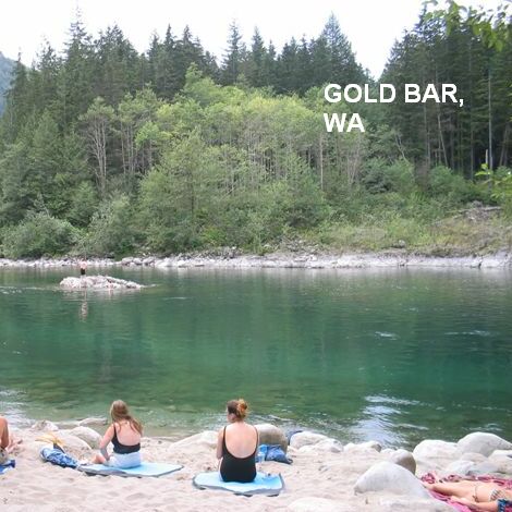
GOLD BAR [GOLB]: A short distance east of Gold Bar on RT 2, the road crosses a bridge over the Skykomish River (if you get to Index you have gone too far). On one end of this bridge or the other (don't know which) there is a pull off and a gravel roundabout. There is plenty of parking - perhaps it is a boat launch area - and a $5 day use fee in the summer. It's never very crowded for swimmers, but lots of people launch their kayaks and rafts there. There are picnic tables and a few fire pits. The swimming hole is here. PHOTO 1 , PHOTO 2 , PHOTO 3 .
LAT, LON : lat=47.83753, lon=-121.65894(source: DeLorme) (accuracy:approximate) LINK TO GOOGLE MAP. Uncertain on location. Not verified. Updated 11/24/05.
EAGLE FALLS [EAGL]: About 2 miles past (east of) Index, where the road follows the river, there is a large turnout and (maybe) a sign that says Eagle Falls. Park walk a trail down into the gorge below the falls to huge swimming holes. WEB SITE
LAT, LON : lat=47.79563, lon=-121.51414 (source: web site) (accuracy:approximate) LINK TO GOOGLE MAP. Pretty confident. Not verified. Updated 1/2013.
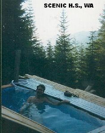
SCENIC HOT SPRINGS [SCEN]: This spectacular hot springs, high on a hillside with a steep hike up, is reopened under a steward/permission system. PHOTO . There are several persons who act as on-site stewards, authorized by the private property owner. DO NOT ATTEMPT TO GO HERE WITHOUT PERMISSION (we do not give directions here to help avoid - ask for directions when you get your permission). REQUEST PERMISSION. Read about Scenic at SCENIC HOT SPRINGS FORUM. LAT, LON : lat=47.708944, lon=-121.138066(source: DeLorme) (accuracy:approximate) LINK TO GOOGLE MAP.
|
|---|
|
CONFIDENCE | Varies - see above |
|---|
|
VERIFIED | Varies - see above |
|---|
|
DATE UPDATED | 1/2013 |
|---|
|
|---|
This swimming hole listing is by
www.swimmingholes.org
SNOQUALMIE RIVER AREA
[4 PLACES]
(SNOQ)
|
|
TOWNS | SEATTLE, NORTH BEND, FALL CITY |
|---|
|
STATE | WA |
|---|
|
WATER | Snoqualmie River |
|---|
|
TYPE | Falls/River |
|---|
|
DESCRIPTION | Popular unoffical swimming areas in Snoqualmie River and nearby. BE CAREFUL OF CURRENTS HERE - DO NOT GO IN IF CURRENT IS STRONG! PEOPLE HAVE DROWNED IN THESE PLACES RECENTLY. WHEN CURRENTS ARE LOW IN LATE SUMMER IS THE TIME TO SWIM HERE. |
|---|
|
AREA | None |
|---|
|
SANCTION | Unofficial |
|---|
|
FEE | Fee at Goldmyer HS, otherwise none |
|---|
|
FACILITIES |
Unknown |
|---|
|
ACTIVITIES |
Swimming, Jumping, Hot tubbing |
|---|
|
PHONE | Unknown |
|---|
|
CAMPING | Unknown |
|---|
|
BATHING SUITS | Optional at Goldmyer HS, otherwise unknown |
|---|
|
DIRECTIONS | From Seattle, take I-90 east to North Bend, then:
BLUE HOLE SNOQUALMIE [BLUS]: Popular swimming hole in the "Little Si Natural Area" at the foot of the Little Si mountain in the Middle Fork Snoqualmie River. BE CAREFUL OF CURRENTS HERE - DO NOT GO IN IF CURRENT IS STRONG! PEOPLE HAVE DROWNED IN THIS PLACE RECENTLY. THE SHERIFF HAS CLOSED THIS LOCATION WHEN THE CURRENTS ARE STRONG. WHEN CURRENTS ARE LOW IN LATE SUMMER IS THE TIME TO SWIM HERE. LAT, LON : lat=47.49852, lon=-121.76154(source: Geocaching site) (accuracy: approximate) LINK TO GOOGLE MAP. To get here, get off I-90 at exit 31 in North Bend and take RT 202 north then go right on W 4th and continue onto E 4th then left on Ballarat Ave then right on NE 6th and continue onto SE 114 to end and hike down to river. No better directions. Pretty confident. Not verified. Updated 12/28/2007.
SNOQUALMIE FALLS [SNOF]: Popular falls for viewing with unoffical swimming and jumping from rocks in pool at the bottom. BE CAREFUL OF CURRENTS HERE - DO NOT GO IN IF CURRENT IS STRONG! WHEN CURRENTS ARE LOW LATE SUMMER IS THE TIME TO SWIM HERE.
LINK TO PHOTOS AND MAPS.
LAT, LON : lat=47.54528, lon=-121.8411(source: USGS) (accuracy:exact) LINK TO GOOGLE MAP. To get here continue north on RT 202 through North Bend and before you get to Fall City, at Spring Glen, go left on Southeast Fish Hatchery Road. Follow that down to the river. About 200 yards before the bridge over Tokul Creek, find a parking spot to the right. A rocky outcropping here on the riverbank provides a prime spot to view the falls. To swim, at the falls pool, continue to the road's end, to a gravel parking area. Go around the gate and walk a paved road down to one of Puget Sound Energy's powerhouses. The trail to the pool goes behind the powerhouse. Pretty confident. Not verified. Updated 12/28/2007.
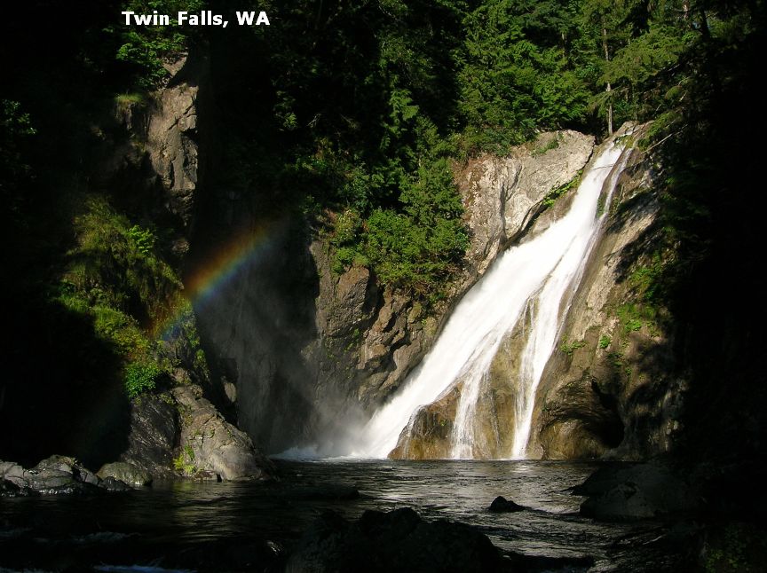
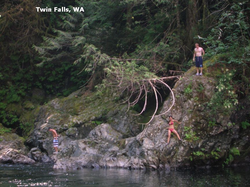
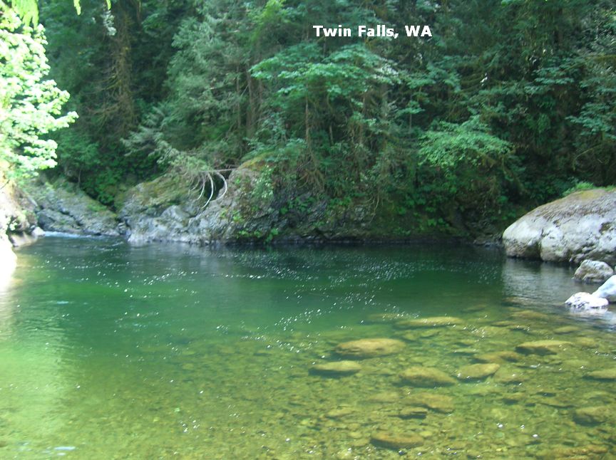
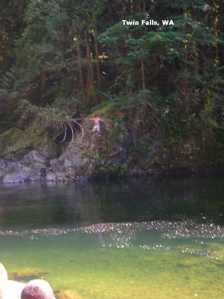
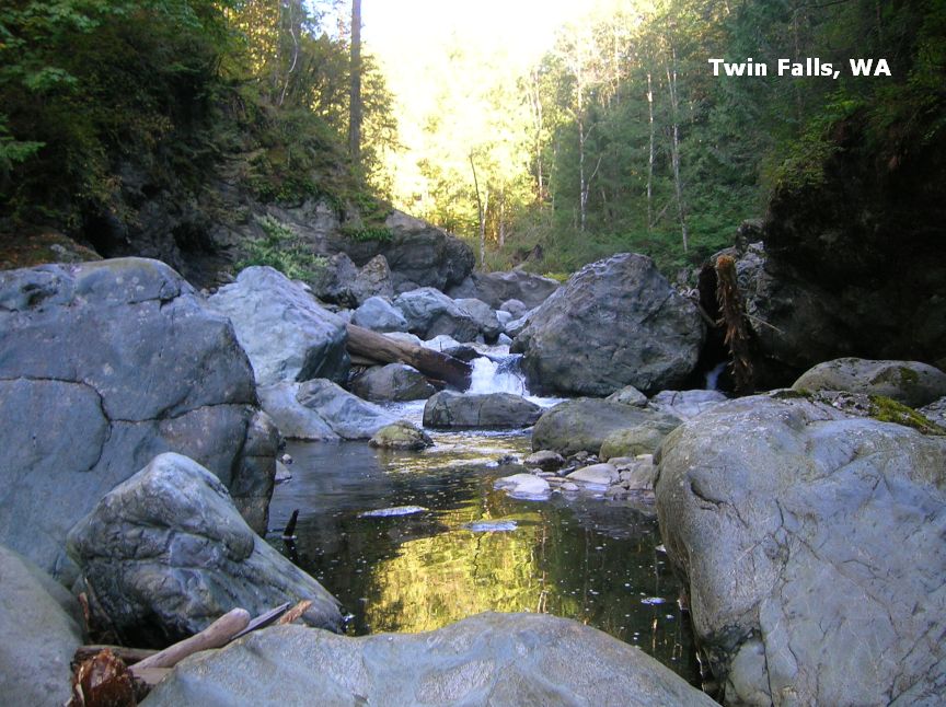
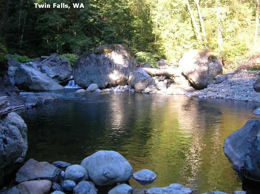
TWIN FALLS [TWIN]: Great falls for swimming and some jumping too in the Snoqualmie River. This is a 1 mile hike in Olallie State Park through old growth trees and waterfalls. BE CAREFUL OF CURRENTS HERE - DO NOT GO IN IF CURRENT IS STRONG! WHEN CURRENTS ARE LOW LATE SUMMER IS THE TIME TO SWIM HERE. STATE PARK WEB SITE , MAP STATE PARK AND TWIN FALLS TRAILS . PHOTO , PHOTO , PHOTO , PHOTO , PHOTO , PHOTO .
LAT, LON : lat=47.44503, lon=-121.69636(source: DeLorme) (accuracy:exact) LINK TO GOOGLE MAP.
To get here, stay on I-90 past North Bend for about another 4 miles and take Exit 34. Take 468th Ave SE south (you will have to turn to keep on 468th Ave) then turn left on SE 159th ST and continue to the parking area for Olallie State Park and the Twin Falls area. These directions from a local visitor:" Park and follow the MAIN TRAIL (it's obvious) for about 15 minutes until you reach the BIG TREE. You'll know it when you see it, it even has a wooden fence around it with a protection sign. Turn RIGHT at the BIG TREE. This is the SECRET TRAIL. It will take you off the MAIN TRAIL and lead you to another tree with long sagging branches.
Use these branches to climb down the path onto the riverbed (safe and easy). Stay LEFT. You must now walk to the WATERFALL/Swimming hole by jumping across the river rocks and walking alongside the river (still safe and easy).
This is where the REAL ADVENTURE begins! BE SAFE! BUDDY SYSTEM! When you start to hear and see the WATERFALL, keep on going, you're almost there! Below the waterfall is a huge Swimming Hole. (If you make it to the river and want to take a RIGHT instead of a left... go ahead. This is where I have found THREE more waterholes (one with even more sunlight). But these are much harder to get to, and take a long time too (20-30 minutes). But its SOOO WORTH IT!)"
GOLDMYER HOT SPRINGS [GOLD]:4.5 mile hike each way. No crowds, no trash, just bucolic soaking in a natural setting. Nudity common, clothing optional. Only 20 soakers allowed per day - get a reservation at the web site below or phone 206.789.5631 during office hours. Fee is charged. No dogs, no alcohol, and no smoking. Enforced by live-in caretakers. See web site for all info and photos. WEB SITE (be sure to read). LAT, LON (of Dingford Creek Trailhead) : lat=47.51656, lon=-121.4515 (source: map) (accuracy:approximate) LINK TO GOOGLE MAP. LAT, LON (of Goldmyer Hot Spring) : lat=47.48383, lon=-121.39221(source: map) (accuracy:approximate) LINK TO GOOGLE MAP.
To get here from I-90 go past North Bend 4 miles and take Exit 34 (above). Then head north on 468th ave SE and turn east (right) on SE Middle Fork Road, a gravel drive (along Middle Fork Snoqualmie River) and continue for about 15 miles (becomes NF 5600) to Middle Fork Campground then turn east (right) onto NF 5620 and continue (along the Snoqualmie River) to the Dingford Creek Trailhead (see lat lon above). The road becomes a trail at this point. Park and hike on down the road you were just on for about 4 miles then turn right for the short trail to Goldmyer Hot Springs. Very confident. Not verified. Updated 9/2014.
|
|---|
|
CONFIDENCE | Very confident |
|---|
|
VERIFIED | No |
|---|
|
DATE UPDATED | 9/2014 |
|---|
|
|---|
This swimming hole listing is by
www.swimmingholes.org
SQUIRE CREEK PARK
(SQUI)
|
|
TOWNS | EVERETT, ARLINGTON, DARRINGTON |
|---|
|
LAT, LON | lat=48.27194, lon=-121.6729(source: map) (accuracy: approximate)
LINK TO GOOGLE MAP |
|---|
|
STATE | WA |
|---|
|
WATER | Squire Creek |
|---|
|
TYPE | Creek |
|---|
|
DESCRIPTION | County park with camping, picnicing and a beach along the creek for swimming. |
|---|
|
AREA | County Park |
|---|
|
SANCTION | Unknown |
|---|
|
FEE | Unknown |
|---|
|
FACILITIES |
All facilities |
|---|
|
ACTIVITIES |
Swimming |
|---|
|
PHONE | 360-436-1283 |
|---|
|
CAMPING | Developed camping at site (no hookups, reservations available.) |
|---|
|
BATHING SUITS | Required |
|---|
|
DIRECTIONS | From I-5 north of Everett take RT 530 east through Arlington then drive 26 miles toward Darrington. Before you get to Darrington, see signs for Squire Creek County Park and park entrance on the left.
|
|---|
|
CONFIDENCE | Pretty confident |
|---|
|
VERIFIED | No |
|---|
|
DATE UPDATED | 4/2011 |
|---|
|
|---|
This swimming hole listing is by
www.swimmingholes.org
TANEUM CREEK
(TANE)
|
|
TOWNS | ELLENSBURG |
|---|
|
LAT, LON | lat=47.08842, lon=-120.81763(source: measured by another) (accuracy: approximate)
LINK TO GOOGLE MAP |
|---|
|
STATE | WA |
|---|
|
WATER | Taneum Creek |
|---|
|
TYPE | Creek |
|---|
|
DESCRIPTION | This from a fan:"Popular swimming hole with a deep pool in the front creek and a great wide shallow play area directly across and above the creek."
|
|---|
|
AREA | Wenatchee National Forest |
|---|
|
SANCTION | Unofficial |
|---|
|
FEE | Unknown |
|---|
|
FACILITIES |
None at site |
|---|
|
ACTIVITIES |
Swimming |
|---|
|
PHONE | unknown |
|---|
|
CAMPING | Three N.F. campgrounds a short way further west on Taneum Creek Rd. |
|---|
|
BATHING SUITS | Optional sometimes - see below |
|---|
|
DIRECTIONS |
DIRECTIONS: This from a fan: "From Ellensburg proceed on I-90 West and take the Thorp exit and Left, (South,) over the freeway and then turn Right, (West), onto Thorp Cemetery Rd.. Continue straight and onto Taneum Creek Rd. to the wide out parking area on the left. Walk down to the creek and go left and through the log jam to the semi to very private swimming area which is a large 6-8' deep pool and sandy beach. The spot can be crowded on weekends so bathing suits customary on weekends, (or by consent of those present), but no need for clothes on weekdays." |
|---|
|
CONFIDENCE | Very confident |
|---|
|
VERIFIED | By another |
|---|
|
DATE UPDATED | 1/2014 |
|---|
|
|---|
This swimming hole listing is by
www.swimmingholes.org
TEANAWAY RIVER
(TEAN)
|
|
TOWNS | ELLENSBURG, CLE ELUM |
|---|
|
LAT, LON | lat=47.28333, lon=-120.86185(source: measured by another) (accuracy: approximate)
LINK TO GOOGLE MAP |
|---|
|
STATE | WA |
|---|
|
WATER | Teanaway River |
|---|
|
TYPE | River |
|---|
|
DESCRIPTION | This from a fan:"One of several beautiful hike-in only swimming holes on a 1/2 mile long stretch of the river. The river flows over a soft rock shelf which has carved many pools and chutes, as well as, makes the water warmer than most mountain rivers. Bathing suits customary."
|
|---|
|
AREA | Wenatchee National Forest |
|---|
|
SANCTION | Unofficial |
|---|
|
FEE | Unknown |
|---|
|
FACILITIES |
None at site |
|---|
|
ACTIVITIES |
Swimming |
|---|
|
PHONE | unknown |
|---|
|
CAMPING | N.F. campgrounds nearby |
|---|
|
BATHING SUITS | Varies - see below |
|---|
|
DIRECTIONS |
This from a fan: "From Ellensburg proceed on I-90 West to Cle Elum. In Cle Elum, take RT 970 east about 9 miles (keep left to stay on RT 970, do not go onto RT 10) then turn north (left) on Teanaway Rd.. Follow Teanaway Rd for 10.3 miles to the gated 'Dickey Creek' NF-115 access road just past a bridge over the river. Park and hike up the gated road approx. 100yds to where the trail heads off to the right and down to the river. Follow this trail another 100yds to the first swimming area. Bathing suits customary here."
"For more freedom hike another 100yds. downstream to a more remote and wide open swimming/sunning area that is perfect for skinny dipping (suits optional)."
|
|---|
|
CONFIDENCE | Very confident |
|---|
|
VERIFIED | By another |
|---|
|
DATE UPDATED | 1/2014 |
|---|
|
|---|
This swimming hole listing is by
www.swimmingholes.org
WALLA WALLA AREA
[5 PLACES]
(WALA)
|
|
TOWNS | YAKIMA, RICHLAND, KENNEWICK, WALLA WALLA
|
|---|
|
STATE | WA |
|---|
|
WATER | Varies -see below |
|---|
|
TYPE | River |
|---|
|
DESCRIPTION | In all directions from Walla Walla are swimming hole opportunities, mostly in the Walla Walla River and its forks. For details, see DIRECTIONS below. |
|---|
|
AREA | Unknown |
|---|
|
SANCTION | Unofficial |
|---|
|
FEE | None |
|---|
|
FACILITIES |
None |
|---|
|
ACTIVITIES |
Swimming, jumping |
|---|
|
PHONE | None |
|---|
|
CAMPING | Developed camping at Palouse Falls S. P. and at Hood Park. Primitive/dispersed camping at other locations on BLM lands. |
|---|
|
BATHING SUITS | Unknown |
|---|
|
DIRECTIONS |
Walla Walla is east of the Tri Cities area of Richland/Pasco/Kennewick on RT 12. All directions are from Walla Walla.
PALOUSE FALLS (PALO): Several swimming opportunities in the Palouse river about 1.5 hours north of Walla Walla. From Walla Walla, take RT 12 east about 45 miles then turn left on RT 261 north about 20 miles to the Palouse Falls State Park. Go to the overlook of the main falls (the swimming places are NOT at the main falls). From here, walk upstream on a trail that goes along the railroad tracks and look for a rapids - this is Little Palouse Falls. Swimming is at the bottom of falls or, if you walk back a bit (downstream) on the trail and clamber steeply down to the river. LAT, LON: lat=46.66357, lon=-118.2241 (source: map) (accuracy:general area) LINK TO GOOGLE MAP. Pretty confident. Not verified. Updated 4/2011.
SOUTH FORK WALLA WALLA (SOUW) : Great swimming opportunity in the South Fork of the Walla Walla. From Walla Walla, go south on RT 11 to Milton Freewater. On the south side of Milton Freewater take the Walla Walla River Rd. (toward Harris County Park), taking a left at the Harris County Park sign. After several miles there is a fork - here take the South Fork Walla Walla River Road. Continue on this road (past Harris Park) and you�ll cross two bridges, there is a deep swimming hole and sand bar under the second bridge. LAT, LON: lat=45.83098, lon=-118.17118 (source: map) (accuracy:general area) LINK TO GOOGLE MAP. Pretty confident. Not verified. Updated 4/2011.
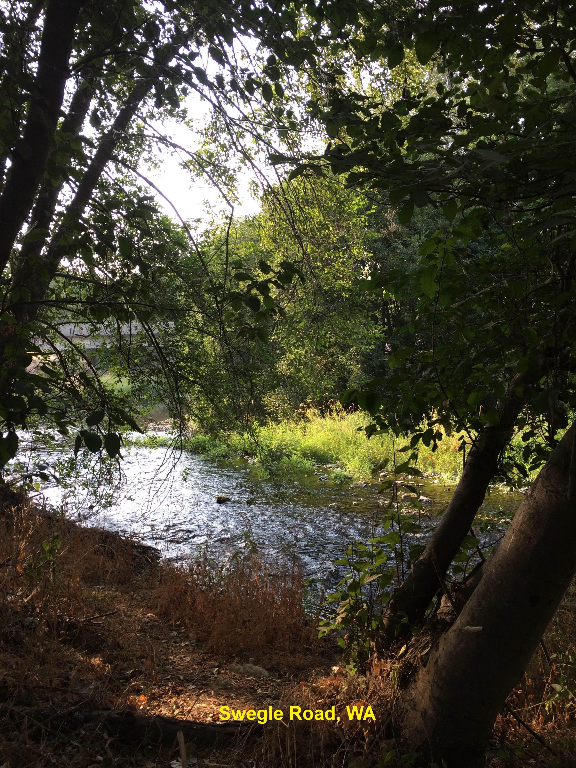
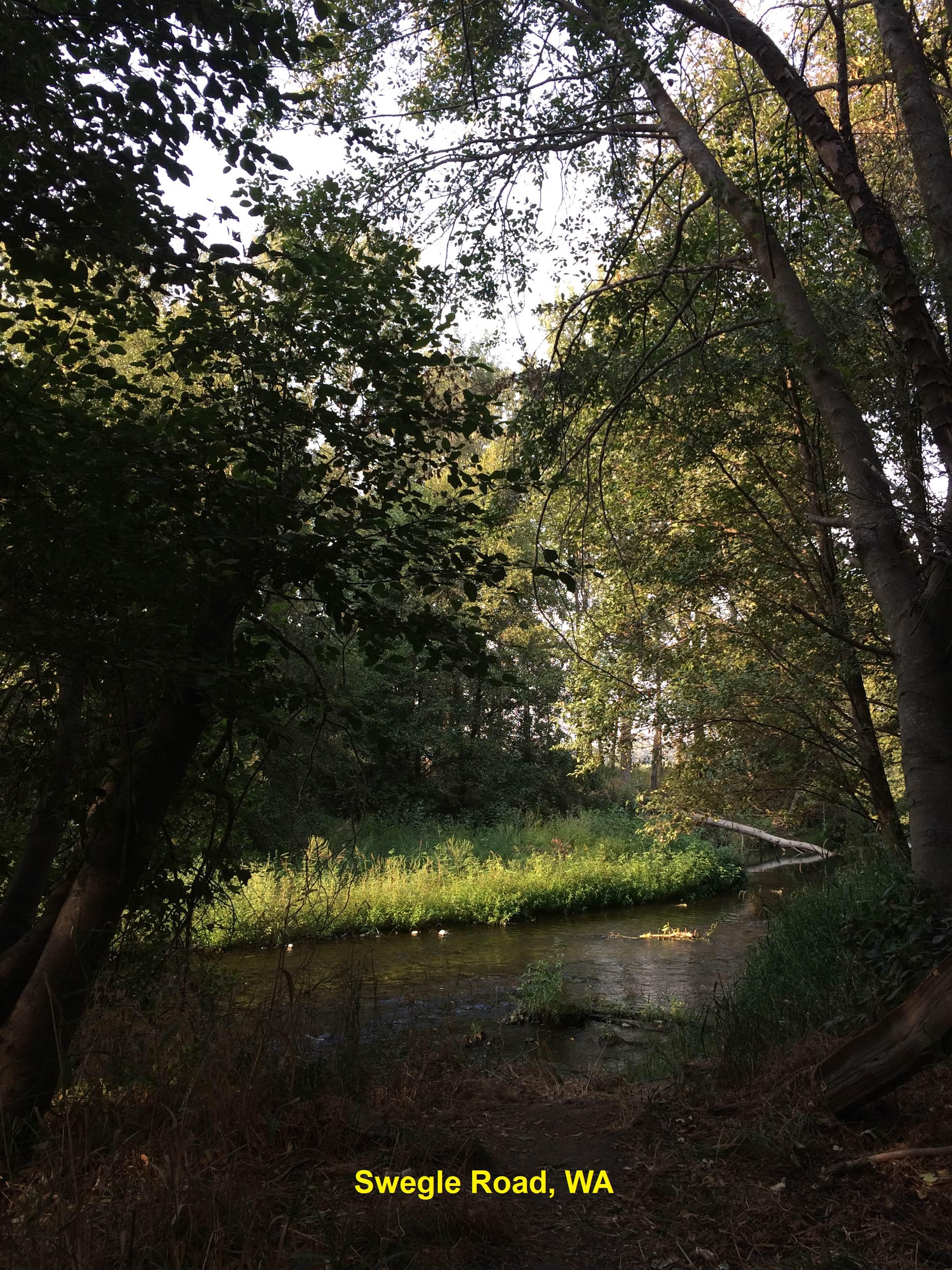
SWEGLE ROAD (SWEG) : Another swimming place on the Walla
Walla - close to the town, near the Whitman Mission Historic Site. From
Walla Walla go west on RT 12 for 7 miles then turn south (left) onto Swegle
Road (look for brown park signs). Go over the railroad tracks and then to a
bridge (less than 1/2 mile). Park on the left just after you cross the
bridge. The swimming place is here and, if you walk along the river a bit,
there are other places. PHOTO
PHOTO
PHOTO LAT, LON: 46.03690,
-118.47137 LINK TO GOOGLE MAP.
Pretty confident. Not verified. Updated 2/20/2016.
WALLA WALLA CLIFFS (WALC) : CAUTION: THIS IS A DANGEROUS AND ILLEGAL JUMPING PLACE - A JUMPER DIES HERE MOST EVERY YEAR. WATER DEPTH VARIES BY SEASON - CHECK DEPTH EVERY TIME YOU GO. NEVER DIVE HEADFIRST. WEAR GOOD FOOTWEAR, THE CLIMB BACK UP IS TOUGH. The cliff jump heights can vary from 10 to 30 feet. To get here from Walla Walla, take RT 12 west toward the Tri Cities and, just before the road crosses the Walla Walla River, turn south (left) onto Byrnes Rd. Drive south on Byrnes Rd. for less than a mile, and look for a pull off on the right. The cliffs are here. LAT, LON: lat=46.06214, lon=-118.77821 (source: map) (accuracy: approximate) LINK TO GOOGLE MAP. Pretty confident. Not verified. Updated 1/2013.
HOOD PARK (HOOD): This is a Army Corps of Engineers park on the Snake River near the Tri Cities area - Richland/Pasco/Kennewick. Official swimming area with developed camping at the site. To get here from Walla Walla, take RT 12 west toward the Tri Cities Airport and, just before you cross the Snake River bridge exit into Hood Park. The swimming area is here in the Snake River. LAT, LON: lat=46.21405, lon=-119.01215 (source: map) (accuracy: approximate) LINK TO GOOGLE MAP. Pretty confident. Not verified. Updated 4/2011.
|
|---|
|
CONFIDENCE | Pretty confident |
|---|
|
VERIFIED | Not verified |
|---|
|
DATE UPDATED | 1/2013 |
|---|
|
|---|
This swimming hole listing is by
www.swimmingholes.org
WANAPUM LAKE
(WANA)
|
|
TOWNS | ELLENSBURG, YAKIMA |
|---|
|
LAT, LON | lat=46.91659, lon=-119.95171(source: measured by another) (accuracy: approximate)
LINK TO GOOGLE MAP |
|---|
|
STATE | WA |
|---|
|
WATER | Wanapum Lake (Columbia River) |
|---|
|
TYPE | Lake/River |
|---|
|
DESCRIPTION | This from a fan:"I have a great swimming hole and beach on Wanapum Lake behind the dam on the Columbia River. It's a fairly secluded wide sandy beach and large shallow water swimming area on a cove of the Columbia River in the Sand Hollow Recreation Site run by the Grant County PUD. It is 'fairly' secluded because you must hike about 1/2 mile from the parking area on a trail through high sage and soft sand and few attempt it, or arrive by boat to reach this spot against the stone cliffs.
Sand Hollow is a primitive and 'free' walk-in camping area with port-a-potty's. The beach is accessed by following the trail SE past the camping areas and all the way to the cliff walls and heading down to the water. Weekdays you will usually have it to yourself. Weekends, this is a very popular camping area and many boaters. Though not a 'legal' nude area, it sees regular clothing optional use and is a great spot for it. We have been there dozens of times and love it. Be respectful of others, watch for Rattlesnakes and please pack out your trash. Enjoy!"
|
|---|
|
AREA | Sand Hollow County Recreation Site |
|---|
|
SANCTION | Unofficial |
|---|
|
FEE | None |
|---|
|
FACILITIES |
None at site |
|---|
|
ACTIVITIES |
Swimming |
|---|
|
PHONE | None |
|---|
|
CAMPING | Primitive walk-in camping at the site. Developed campground across the lake at Wanapum State Park |
|---|
|
BATHING SUITS | Optional |
|---|
|
DIRECTIONS |
DIRECTIONS: This from a fan:"From Ellenburg, take I-90 east a short way to Vantage, then take I-90 across the River and take exit 137 onto RT 26 east towards Royal City/Othello. In 1 mile turn south (right) onto RT 243 south along the east side of the lake. In 0.3 miles turn west (right) into the gravel parking area next to the lake. Park and hike the 1/2 mile trail along the lake to the swimming cove against the cliffs. " |
|---|
|
CONFIDENCE | Very confident |
|---|
|
VERIFIED | By another |
|---|
|
DATE UPDATED | 1/2014 |
|---|
|
|---|
This swimming hole listing is by
www.swimmingholes.org
WASHOUGAL AREA
[7 PLACES]
(WASA)
|
|
TOWNS | VANCOUVER, WASHOUGAL,
|
|---|
|
STATE | WA |
|---|
|
WATER | Washougal River |
|---|
|
TYPE | River |
|---|
|
DESCRIPTION | Along the Washougal River, north and east of Washougal, are a number of swimming holes. For details, see DIRECTIONS below. |
|---|
|
AREA | Unknown |
|---|
|
SANCTION | Unofficial |
|---|
|
FEE | None |
|---|
|
FACILITIES |
Varies - see below |
|---|
|
ACTIVITIES |
Swimming, jumping |
|---|
|
PHONE | None |
|---|
|
CAMPING | Developed camping at Battleground S. P. north of Washougal and at Dougan Falls Campground (see below). |
|---|
|
BATHING SUITS | Unknown |
|---|
|
DIRECTIONS | Washougal is east of Vancouver at the junction of the Columbia River and the Washougal River. All directions are from Washougal, going north along the Washougal River Rd.:
SANDY (SAND): Park with picnic tables and restrooms and swimming in the Washougal River. Very crowded on warm weekend days - can be hard to park then. To get here from Washougal, take Washougal River Rd north , cross over the river then turn left on Shepard Road. Continue for about .7 miles to the park. LAT, LON: lat=45.58881, lon=-122.36679 (source: map) (accuracy:approximate) LINK TO GOOGLE MAP. Pretty confident. Not verified. Updated 4/2011.
THREE MILE (THRE): At about the 3 mile marker on the Washougal River Rd north is a Fish and Wildlife area, well wooded with great swimming. Pay to park here. To get here continue north on Washougal River Rd. to about mile marker 3. LAT, LON: lat=45.58642, lon=-122.35360 (source: map) (accuracy: approximate) LINK TO GOOGLE MAP. Pretty confident. Not verified. Updated 4/2011.
|
BIG EDDY (BIGE): At about the 7 mile marker on the Washougal River Rd north is a great swimming family hole with a rope swing and rapids to tube through. To get here continue north on Washougal River Rd. to just past mile marker 7. LAT, LON: lat=45.62337, lon=-122.33384 (source: map) (accuracy: approximate) LINK TO GOOGLE MAP. Pretty confident. Not verified. Updated 4/2011. |
|
FISHING HOLE (FISH): At about the 8 mile marker on the Washougal River Rd north is a Fish and Wildlife area with little rapids, swimming holes, well wooded and bathrooms. Pay to park here. To get here continue north on Washougal River Rd. to just past mile marker 8. LAT, LON: lat=45.62775, lon=-122.31410 (source: map) (accuracy: approximate) LINK TO GOOGLE MAP. Pretty confident. Not verified. Updated 4/2011.
|
DOUGAN FALLS RECREATION AREA (DOUF): About 20 miles up the Washougal River Rd north, at a National Forest campground and recreation area, is large falls with many levels and pools to swim in. INFO ON WEB . To get here continue north on Washougal River Rd. about 20 miles more and watch for signs. LAT, LON: lat=45.67329, lon=-122.15615 (source: map) (accuracy: approximate) LINK TO GOOGLE MAP. Pretty confident. Not verified. Updated 4/2011. |
|
BRIDGE FALLS (BRID): To get here continue north on Washougal River Rd. from Dougan Falls (above), keep right at the fork, and, after you cross two bridges, see the falls on the left. Swimming is in the pool at the bottom of falls. Bathing suits may be optional here.LAT, LON: lat=45.71874, lon=-122.12304 (source: map) (accuracy: general area) LINK TO GOOGLE MAP. Uncertain of exact location. Not verified. Updated 4/2011.
JUMPING CLIFFS (JUMP): Very high cliff with several different heights to jump from into a deep pool below. To get here continue a short way north on Washougal River Rd. from Bridge Falls (above) around a bend then see the cliffs on the left. LAT, LON: lat=45.72784, lon=-122.13110 (source: map) (accuracy: general area) LINK TO GOOGLE MAP. Uncertain of exact location. Not verified. Updated 4/2011.
|
|---|
|
CONFIDENCE | Pretty confident |
|---|
|
VERIFIED | Not verified |
|---|
|
DATE UPDATED | 4/2011 |
|---|
|
|---|
This swimming hole listing is by
www.swimmingholes.org
WHATCOM FALLS PARK
(WHAT)
|
|
TOWNS | SEATTLE, BELLINGHAM |
|---|
|
LAT, LON | lat=48.74988, lon=-122.42984(source: map) (accuracy: approximate)
LINK TO GOOGLE MAP |
|---|
|
STATE | WA |
|---|
|
WATER | Whirlpool Falls/Whatcom Creek |
|---|
|
TYPE | Falls/Creek |
|---|
|
DESCRIPTION | Popular swimming hole at Whirlpool Falls in Whatcom City park in Bellingham. CAUTION: There are shallow places and rocks in the water here. In recent years, several people have been killed, injured or paralyzed jumping into these waters. Check the depth and for rocks before you jump.
Whirlpool Falls is a very popular swimming hole within the park. The falls themselves are only about ten feet in height but the cliffs adjacent to the falls reach to about 30 feet high. During the summer one can usually watch swimmers jumping from these tall cliffs into the punchbowl pool below. The falls are located along the "Whirlpool Loop Trail." WEB SITE , MAP |
|---|
|
AREA | Whatcom Falls Park |
|---|
|
SANCTION | Unofficial |
|---|
|
FEE | Unknown |
|---|
|
FACILITIES |
All facilities, picnic, playground |
|---|
| ACTIVITIES |
Swimming, picnicking |
|---|
|
PHONE | Unknown |
|---|
|
CAMPING | None at site. |
|---|
|
BATHING SUITS | Required |
|---|
|
DIRECTIONS | From I-5 exit 253 in Bellingham, take Lakeway Dr. east about 1.75 miles Turn left onto Silver Beach Rd and enter Whatcom Falls Park. Whatcom Falls Park is located at 1401 Electric Avenue in the Whatcom Falls Neighborhood of Bellingham. Hike the "Whirlpool Loop Trail" to the falls. |
|---|
|
CONFIDENCE | Pretty confident |
|---|
|
VERIFIED | No |
|---|
|
DATE UPDATED | 1/2013 |
|---|
|
|---|
This swimming hole listing is by
www.swimmingholes.org
WIND RIVER AREA
[2 PLACES]
(WIND)
|
|
TOWNS | PORTLAND (OR), VANCOUVER (WA), WASHOUGAL, CARSON |
|---|
|
STATE | WA |
|---|
|
WATER | Hot Springs/Dry Creek |
|---|
|
TYPE | Hot Springs/Falls |
|---|
|
DESCRIPTION | Here's another "two-fer" hot springs/cold falls combination not too far from each other in southern Washington in the Columbia River Gorge area. For details, see DIRECTIONS below.
|
|---|
|
AREA | Gifford Pinchot N.F./Private land |
|---|
|
SANCTION | Unofficial |
|---|
|
FEE | None |
|---|
|
FACILITIES |
Unknown |
|---|
|
ACTIVITIES |
Hot soaking, Swimming |
|---|
|
PHONE | None |
|---|
|
CAMPING | There are several N.F. campgrounds on RT 14 north of Carson in the Pinchot N.F. |
|---|
|
BATHING SUITS | Probably Optional |
|---|
|
DIRECTIONS | From Vancouver take RT 14 east to Carson, then:
DRY CREEK FALLS [DRYC]: Also known as Puff Falls. High falls into pool at bottom for swimming. Cold water! To get here from RT 14 near Carson, go north on Wind River Rd (along the Wind River) into the Gifford Pinchot N.F. (this road becomes FR 30 in the N.F.). At about 17 miles from Carson, go northwest (left turn) onto FR 64 which goes along the Dry River. Go about 2.1 miles on FR 64 to the place where this road crosses the creek and park. Walk upstream just under 1 mile (some slow going) to the falls - the swimming hole is in the pool at the bottom of the falls.
LAT, LON :lat=45.92628, lon= -121.97917(source: DeLorme) (accuracy: approximate) LINK TO GOOGLE MAP. Not verified. Pretty confident. Updated 12/5/2005.
WIND RIVER HOT SPRINGS [WINH]: Also known as "St. Martins
on the Wind". The customary, old trail to this place is on private property
and is now very extensively posted. "
To get here from RT 14 near Carson, stay on RT 14 east, take the turn for Carson and go to the Carson Hot Springs Hotel. Follow the directions above from the hotel. Not verified. Pretty confident. Updated 3/2010.
LAT, LON :lat=45.72875, lon=-121.79547(source: DeLorme) (accuracy:approximate) LINK TO GOOGLE MAP.
|
|---|
|
CONFIDENCE | Pretty confident |
|---|
|
VERIFIED | No |
|---|
|
DATE UPDATED | 3/2010 |
|---|
|
|---|
HOME/
|