This swimming hole listing is by
www.swimmingholes.org
ADAMS HOLE
(ADAM)
|
|
| TOWNS |
ST. JOHNSBURY, EAST BARNET, DANVILLE |
| LAT,
LON |
Lat:44.34333
Lon:-72.06111 Source : MapPoint
Accuracy : Approximate
Link to Google Map
|
| STATE |
VT |
| WATER |
Joes Brook |
| TYPE |
Brook |
| DESCRIPTION |
Nice little local swimming hole on
Joe's Brook between Danville and East Barnet. |
| AREAS |
None |
| SANCTION |
Unofficial |
| FEE |
None |
| FACILITIES |
None |
| ACTIVITIES |
Swimming |
| PHONE |
None |
| CAMPING |
Not at site. |
| BATHING
SUITS |
Unknown |
| DIRECTIONS |
From St.
Johnsbury, go south on RT 5 and turn west (right) on Joe's Brook Road
about 2 miles before East Barnet. Take Joe's Brook Rd. toward Danville.
When the road becomes gravel, go about .5 miles further and there is a
pull off on the right. The swimming hole is near here in Joe's Brook.
|
| CONFIDENCE |
Pretty Confident |
| VERIFIED |
No |
| DATE
UPDATED |
11/17/2002 |
This swimming hole listing is by
www.swimmingholes.org
ARLINGTON AREA
3 PLACES
(ARLI)
|
|
| TOWNS |
BENNINGTON, ARLINGTON, WEST
ARLINGTON, EAST ARLINGTON |
| STATE |
VT |
| WATER |
Varies See Description |
| TYPE |
Varies See Description |
| DESCRIPTION |
ARLINGTON GREEN [ARLI]:
Regional favorite swimming hole under a covered bridge. There is a small grassy area ideal
for picnicking.
NONAME
HOLE
[NONA]: The swimming hole in Mill Brook consists of a
number of slide-type water falls with small pools beneath them.
PHOTO1 The
upper pool is the largest, it is not deep enough to safely jump into,
but plenty deep enough to swim. Below this pool are 2 or 3 additional
pools that look great to relax in. One interesting feature are the
rocks--they are pinkish in color and, combined with the clear water,
give a nice shade to the pools.
PHOTO2
GROUT POND [GPON]:
Lakes and ponds aren't usually listed on this website, but this one
is so beautiful and secluded it definitely fits the bill. Grout Pond
is literally in the middle of the Green Mountains and sees few
visitors. The pond is circled with wooded campsites that are best
accessed by canoe. Though the pond is quite big, the swimming area
described here is quite small. If you are looking for a quiet,
bucolic and serene swimming experience, visit this very special
place midweek and bask in the solitude. These pictures were from a
visit in late September with autumn on the doorstep.
PHOTO1
PHOTO2
PHOTO3
|
| AREAS |
Grout Pond Recreational Area |
| SANCTION |
Official at Grout Pond, Unofficial at Arlington Green and No
Name Hole |
| FEE |
None |
| FACILITIES |
Bathrooms at Grout Pond, None at Arlington Green or No Name
Hole |
| ACTIVITIES |
Swimming, Jumping |
| PHONE |
None |
| CAMPING |
At Grout Pond |
| BATHING
SUITS |
Customary |
| DIRECTIONS |
ARLINGTON GREEN [ARLI]: Follow RT
7A north from Bennington, turn left onto RT 313. Look for the covered bridge the left. Confident. Verified Lat/Lon
Lat:43.10406
Lon:-73.22041 Source : Measured
Accuracy : Exact
Link to Google Map
NONAME HOLE [NONA]:
From the village of East Arlington, take Kansas Rd east. The road
crosses over RT 7. Soon after, the road crosses Roaring Brook and
changes into North Rd. Immediately after the bridge, take a right
onto Kelly Stand Rd (this road heads up into Green Mountain National
Forest). About 0.25
mile from the turn, you will pass the waterfalls on your right, there
is an easily seen turnoff. Very Confident. Verified Lat/Lon
Lat:43.05427 Lon:-73.11656
Source : Measured Accuracy : Exact
Link to Google Map
GROUT POND [GPON]:
To get here, follow the directions above for No Name Hole but
continue on Kelly Stand Road past No Name Hole for approximately 10
miles. Kelly Stand Road is a windy, twisting road with beautiful
views of the river. Take your time, be safe and enjoy the ride here.
After ~10 miles, turn right on to Grout Pond Road. Follow the road
past the ranger station, downhill to the parking area. Park here,
walk toward the pond then turn right on the obvious path. Soon you
will see the small grassy area with picnic tables bear a boulder,
lined sandy beach. Very Confident. Verified Lat/Lon
Lat:43.04653
Lon:-72.95106 Source : Measured
Accuracy : Exact Link
to Google Map
|
| CONFIDENCE |
See Above |
| VERIFIED |
See Above |
| DATE
UPDATED |
03/09/2008 |
This swimming hole listing is by
www.swimmingholes.org
BENSON'S HOLE
(BENS)
|
|
| TOWNS |
MANCHESTER |
| LAT,
LON |
Lat:43.16497 Lon: -73.03922 Source:
Measured Accuracy: Exact
Link to Google Map |
| STATE |
VT |
| WATER |
Bromley Brook |
| TYPE |
Brook |
| DESCRIPTION |
Bromley Brook is a
small and brook that flows over and through some very interesting rock
formations which eventually fills the small swimming area at the bottom
of the cascades. Very close to RT 7, this is not an exceptionally
intimate swimming hole, however it does have a fine view of Mt.
Equinox.
|
| AREAS |
None |
| SANCTION |
Unofficial |
| FEE |
None |
| FACILITIES |
None |
| ACTIVITIES |
Swimming |
| PHONE |
None |
| CAMPING |
Not at site |
| BATHING
SUITS |
Customary |
| DIRECTIONS |
Though very close
to RT 7, Benson's Hole is a little tricky to get to. RT 11 and RT 30
combine and the road winds through the Manchester area. From RT 7 take
exit 4 and travel east on RT 11/30 for approximately 0.25 miles. Take a
sharp, hairpin right turn onto East Manchester Road just as RT 11\30
begins to curve left and heads in a northerly direction. It can be very
easy to miss this turn. East Manchester Road heads south then bends
right to head in a westerly direction. In about 0.3 miles from the
bend, you will need to bear left at the fork in the road to remain on
East Manchester Road. If you stay straight here, you will be on Peace
Road, which is a dead end and not where you want to be. After the fork,
take your second left onto Glen Road and park near the small bridge
that crosses Bromley Brook. Follow the shoreline downstream to the
swimming area.
|
| CONFIDENCE |
Very Confident |
| VERIFIED |
Yes |
| DATE
UPDATED |
03/08/2007 |
This swimming hole listing is by
www.swimmingholes.org
BOLTON
POTHOLES
(BOLT)
|
|
| TOWNS |
BURLINGTON, WATERBURY, BOLTON |
| LAT,
LON |
Lat:44.37554
Lon:-72.87605 Source : GPS
Measurement Accuracy : Exact
Link to Google Map |
| STATE |
VT |
| WATER |
Joiner Brook |
| TYPE |
Falls |
| DESCRIPTION |
If you visit here please
make an effort to pick up at least one piece of trash and dispose of it
properly. The number of conscientious swimming hole visitors vastly
outnumber those who abuse these places. If we all expend a small effort
to right the wrongs committed by the thoughtless few, WE CAN MAKE
A DIFFERENCE.
Large round rock
bowls of water for swimming. This is a very popular swimming place.
|
| AREAS |
Mount Mansfield State Forest, Camel's
Hump State Forest
|
| SANCTION |
Unofficial |
| FEE |
No |
| FACILITIES |
None |
| ACTIVITIES |
Swimming, Jumping |
| PHONE |
None |
| CAMPING |
None at site |
| BATHING
SUITS |
Customary at lower pools, optional in
upper pools |
| DIRECTIONS |
How to get there
: From Waterbury, follow RT 2 west approximately 6.5 miles from the
intersection of RT 2 and RT 100 in Waterbury. Take a right onto Bolton
Valley Road. The parking area is 0.25 miles on the right.
How
to act when you are there : Be careful when you are parking or pulling
out of the parking spots. The dirt and gravel are very loose and
spinouts accelerate erosion. Do not use the driveways on private
property to park or turn around. (Would you want hundreds of people
turning around in your driveway every weekend?) Use your own bathroom
before you visit. This beautiful swimming hole is heavily used and
simply cannot accommodate the bathroom needs of a crowd. Yes, it is a
natural thing, but when so many people leave their waste here, it turns
this bucolic place into a cesspool. If you cannot find a safe place to
park, try visiting one of the other swimming holes in Vermont that
are listed on this page.
|
| CONFIDENCE |
Very Confident |
| VERIFIED |
Yes |
| DATE
UPDATED |
03/08/2008 |
This swimming hole listing is by
www.swimmingholes.org
BRISTOL FALLS & CIRCLE CURRENT
(BRIS)
[2 PLACES]
|
|
| TOWNS |
MONTPELIER, BRISTOL, LINCOLN, NEW HAVEN |
| STATE |
VT |
| WATER |
New Haven River |
| TYPE |
Falls, Pools |
| DESCRIPTION |
Bristol Falls
(also known as "Bartlett Falls"), and the upstream area known as Circle
Current, comprise one of the biggest swimming areas in Vermont. Very
popular but certainly enough room for everyone.
BRISTOL FALLS [BRIS]:
Bristol Falls is a 20 foot wide, 15 foot drop
into a deep pool. This wide waterfall spills into a
deep channel approximately 75 yards long with many jumping spots. PHOTO1. This is an extremely popular swimming area and you could find a
few hundred people here on a hot summer day.
LAT, LON Lat:44.12790 Lon:-73.04982 Source:
Measured Accuracy: Exact
Link to Google Map
CIRCLE CURRENT [CIRC]: The area is
very large so it can accommodate a large number of visitors. There
is lot's to do and explore here, so plan to spend several hours.
PHOTO LAT,LON Lat: 44.12446 Lon: -73.03863 Source: Measured Accuracy: Exact
Link to Google Map
|
| AREAS |
Green Mountain National Forest |
| SANCTION |
Unofficial |
| FEE |
No |
| FACILITIES |
None |
| ACTIVITIES |
Swimming, Sliding, Jumping, Jacuzzi |
| PHONE |
None |
| CAMPING |
None at site |
| BATHING
SUITS |
Customary |
| DIRECTIONS |
From Bristol
follow Route 116/17 eastward from the center of Bristol for
approximately 2 miles. Take a right onto Lincoln Gap Road. Keep driving
and listen for the roar of the falls. Parking for Bristol Falls is
first, a little further up the road you will see numerous pull offs for
Circle Current. The New Haven River marks the northern boundary of the
Green Mountain National Forest
|
| CONFIDENCE |
Very Confident |
| VERIFIED |
Yes |
| DATE
UPDATED |
03/16/2008 |
This swimming hole listing is by
www.swimmingholes.org
BROCKWAYS MILLS GORGE
(BROC)
|
|
| TOWNS |
BRATTLEBORO, SPRINGFIELD,
ROCKINGHAM |
|
LAT, LON |
Lat:43.20834
Lon:-72.51701 Source : Measured
Accuracy : Exact
Link to Google Map |
| STATE |
VT |
| WATER |
Williams River |
| TYPE |
River |
| DESCRIPTION |
Falls tumble
through gorge and end in pool at bottom. Train track crosses high above
pool. Some graffiti and litter throughout the gorge. Be careful of
currents and submerged objects in the water!
|
| AREAS |
None |
| SANCTION |
Unofficial |
| FEE |
None |
| FACILITIES |
None |
| ACTIVITIES |
Swimming |
| PHONE |
None |
| CAMPING |
None |
| BATHING
SUITS |
Mixed customary and optional |
| DIRECTIONS |
From Brattleboro,
take I-91 north to Rockingham. From Rockingham,
take the Brockway's Mills Road off RT 103. Park just before the bridge
in the small, dirt parking area near the train tracks. Gorge can be
seen from road. Walk down path
through woods.
|
| CONFIDENCE |
Very Confident |
| VERIFIED |
Yes |
| DATE
UPDATED |
11/17/2002 |
This swimming hole listing is by
www.swimmingholes.org
BURLINGTON AREA
[2 PLACES]
(BURL)
|
|
| TOWNS |
BURLINGTON |
| STATE |
VT |
| WATER |
Lake Champlain |
| TYPE |
Lake |
| DESCRIPTION |
Two swimming areas
in Lake Champlain in or near Burlington.
|
| AREAS |
Burlington |
| SANCTION |
Reds Rock Official Starr Farm -
Unofficial |
| FEE |
Red Rocks - $3.00 Starr Farm -
None |
| FACILITIES |
Unknown |
| ACTIVITIES |
Swimming |
| PHONE |
Unknown |
| CAMPING |
Unknown |
| BATHING
SUITS |
Red Rocks - Optional in nude
area, Starr Farm - Required |
| DIRECTIONS |
RED ROCKS [REDR]: Popular beach on Lake Champlain, both clothed and
nude area.
Clothed area is near parking lot, nude area is down a trail near the
overlook-take a trail from the
overlook down to large, flat rocks at the water edge- no beach here.
(NOTE: The rocks below the waterline have become encrusted with sharp
zebra muscles, an invasive species not native to Lake Champlain. All
visitors should be advised to wear thick-soled shoes before entering
the water.) Confident. Not verified. Lat:44.44121 Lon:
-73.22120 Source: MapPoint Accuracy:
Exact
Link to Google Map
STARR FARM BEACH [STAR] Beach
on Lake Champlain just north of Burlington. Drive north on North
Avenue. Stay on North Avenue past the Y-intersection with Plattsburg
Avenue and take the second left onto Starr Farm Road. Drive
1/2 mile and park in the parking area on right across from
Pleasant Avenue. Walk the bike path north to the
stairs to the beach. Go down the stairs and walk north on the beach a
very short distance past the overhanging trees and over some
large rocks which are easy to negotiate. The large beach area is just
past these trees. It is the only spot on the beach that is raked and
clean. Confident. Not verified. PHOTO1
PHOTO2 Lat :
44.515963 Lon: -73.268981 Source : Measured Accuracy :
Exact
Link to Google Map
|
| CONFIDENCE |
Confident |
| VERIFIED |
No |
| DATE
UPDATED |
5/9/2004 |
This swimming hole listing is by
www.swimmingholes.org
BUTTERMILK FALLS
(BUTT)
|
|
| TOWNS |
RUTLAND, LUDLOW |
| LAT,
LON |
Lat:43.43639 Lon:
-72.72833 Source: Measured Accuracy:
Exact
Link to Google Map |
| STATE |
VT |
| WATER |
Branch Brook |
| TYPE |
Falls |
| DESCRIPTION |
At least 3 falls, with chutes and pools
galore. Walk between falls. Very large, deep pools at bottom of 2 of
these falls.
These falls and swimming places are now preserved for all thanks to the
Vermont River Conservancy,
There is some nude swimming/sunbathing here. It is suggested that if
you wish to go nude, please go down to the third (lowest) pool so that
families can use the upper pools more freely. Thanks.
|
| AREAS |
None |
| SANCTION |
Semi-official |
| FEE |
None |
| FACILITIES |
None |
| ACTIVITIES |
Swimming, Jumping |
| PHONE |
None |
| CAMPING |
Not at site |
| BATHING
SUITS |
Customary upper pools/Optional lower
pool. Also optional across the old, closed bridge at the end of the
road, following paths to the left. |
| DIRECTIONS |
From Ludlow, go
about 5 mi west on RT 103. Just past where RT 100
goes north, turn right at street sign "Buttermilk Falls Rd" (VFW hall
is on right.) Go to the end of this road and park. You can walk to all
falls from here. Take path off right side of road to falls.
|
| CONFIDENCE |
Very Confident |
| VERIFIED |
Yes |
| DATE
UPDATED |
08/16/2008 |
This swimming hole listing is by
www.swimmingholes.org
CAVENDISH GORGE
(CAVE)
|
|
| TOWNS |
CAVENDISH, LUDLOW |
| LAT,
LON |
Lat:43.38275 Lon:
-72.59711 Source: Measured Accuracy:
Exact
Link to Google Map |
| STATE |
VT |
| WATER |
Black River |
| TYPE |
River |
| DESCRIPTION |
The Black River
spills over a dam, then meanders through a rugged, little explored
gorge. Secluded and unpopular, there is a great deal of very exciting
exploration and swimming to be had here. We were somewhat hesitant to
enter the water as it seemed a little dark and murky. Not the best
swimming hole you will ever visit, but not the worst either. Be very careful
entering the steep gorge.
|
| AREAS |
None |
| SANCTION |
Unofficial |
| FEE |
None |
| FACILITIES |
None |
| ACTIVITIES |
Swimming |
| PHONE |
None |
| CAMPING |
Not at site |
| BATHING
SUITS |
Customary |
| DIRECTIONS |
From Ludlow,
follow Rte 103 east for approximately 3 miles to Rte 131 east
through Proctorsville and Cavendish. Approximately
0.4 miles past Cavendish, watch on the right side of Rte 131 for a
small waste water treatment facility near or beside
a small, moderately well maintained dirt road labeled CVPS
road. Turn right onto CVPS Rd and follow to a small parking
area on the left. There is a gate (usually locked) at the
entrance to the power plant., but if found unlocked, do NOT be tempted
to park inside the gate. walk past the gate, (be
respectful now since you are on power plant property) past the power
plant, and follow a grassy path up hill and up river. To your
left will be the gorge, although views from the rim will only
occasionally reveal much of the gorge below.
Continue approximately 0.4 miles upstream almost all the way to the
dam, and find natural breaks in the gorge wall to enter into the
gorge.
|
| CONFIDENCE |
Very Confident |
| VERIFIED |
Yes |
| DATE
UPDATED |
03/09/2008 |
This swimming hole listing is by
www.swimmingholes.org
CLARENDON GORGE
[3 PLACES]
(CLAR)
|
|
| TOWNS |
RUTLAND, CLARENDON |
| STATE |
VT |
| WATER |
Mill River |
| TYPE |
River |
| DESCRIPTION |
High cliffs and a
deep pool with a rope swing. Popular local
swimming holes, lots of parties resulting in some litter.
|
| AREAS |
Green Mountain National Forest |
| SANCTION |
Unofficial |
| FEE |
No |
| FACILITIES |
Unknown |
| ACTIVITIES |
Swimming,
Jumping |
| PHONE |
Unknown |
| CAMPING |
None at site |
| BATHING
SUITS |
Optional/Customary, see below |
| DIRECTIONS |
CLARENDON GORGE [CLAR]: From
Rutland, take RT 7 south. After passing the intersection for RT 103
(Rutland Airport), take your next left onto RT 7B. The road immediately
forks here; left is RT 7B, straight is River Road. The parking area
will be on the right near the large concrete blocks. PHOTO LAT, LON Lat: 43.51633 Lon: -72.96461 Source:
Measured Accuracy: Exact
Link to Google Map
DEVIL'S
GORGE [DEVL]: The safest way to reach the Devil's Gorge is to hike and
swim upstream from the Clarendon Gorge swimming area described
above. It is a reasonably long trek to the falls at the top of the
gorge. This section of the river is extremely private.
PHOTO LAT, LON Lat:
43.51602 Lon: -72.96540 Source: Measured Accuracy: Exact
Link to Google Map
SWINGING BRIDGE [SWIN]: From
Rutland, take RT 7 south. Take a left onto RT 103. Following RT 103 for
approximately 2.5 miles, you will come to a large parking area on the
right just before you cross the railroad tracks. This is used as an
access point to the Long Trail. Park here and follow the well worn path
to the suspension bridge. After crossing the bridge, take the path to the right,
leading down to the river. Follow the river under the bridge to the
swimming areas downstream.
Lat/Lon Lat: 43.51993 Lon: -72.92620 Source: Measured Accuracy:
Exact
Link to Google Map
|
| CONFIDENCE |
Very Confident |
| VERIFIED |
Yes |
| DATE
UPDATED |
03/16/2008 |
This swimming hole listing is by
www.swimmingholes.org
CONGDON'S POINT
(CONG)
|
|
| TOWNS |
RUTLAND, CHITTENDEN |
| LAT,
LON |
Lat:43.71482 Lon:
-72.90536 Source: MapPoint Accuracy:
Approximate
Link to Google Map |
| STATE |
VT |
| WATER |
Leffer's Pond, Chittenden Reservoir |
| TYPE |
Lake |
| DESCRIPTION |
A rocky point on a small lake that has
been a long-time favorite for nude sunbathers and swimmers. |
| AREAS |
Green Mountain National Forest |
| SANCTION |
Unofficial |
| FEE |
Unknown |
| FACILITIES |
Unknown |
| ACTIVITIES |
Swimming |
| PHONE |
Unknown |
| CAMPING |
None at site |
| BATHING
SUITS |
Optional |
| DIRECTIONS |
From the
intersection of RT 4 and RT 7 in the center of Rutland, follow US 7
north for approximately 5.25 miles and take a right onto Sangamon Hill
Road. Follow this road until it ends, then take a left on East
Pittsford Road. This road becomes Main Street just past the left turn
off for Powerhouse Road. Staying on Main Street, you will enter the
center of Chittenden. Mountain Top Road will lead off to the left. Stay
straight and this road is now Chittenden Dam Road. Follow the road
about 2 miles until you see a sign and road for the boat ramp on the
right side, at this point you will be at the foot of the concrete
spillway. Turn right up the boat launch road to the parking
area at the dam.
The trail to Congdon's Point begins about a tenth of a mile or so
behind the bar gate to the right at the top of the boat ramp.
The trail goes left from this old woods road, passes two coves and a
large boulder. Keep the water in sight, as the trail may be a
little confusing north of the boulder. Congdon's Point is the
third and outermost point from the boat ramp. Nude swimmers
and sunbathers have been enjoying this spot for years.
|
| CONFIDENCE |
Pretty Confident |
| VERIFIED |
No |
| DATE
UPDATED |
02/05/2005 |
This swimming hole listing is by
www.swimmingholes.org
THE CORNFIELD
(CORN)
|
|
| TOWNS |
BRATTLEBORO |
| LAT,
LON |
Lat:42.87681 Lon:-72.57341 Source: Map Point Accuracy: Exact
Link to Google Map |
| STATE |
VT |
| WATER |
West River |
| TYPE |
River |
| DESCRIPTION |
The Cornfield is a beautiful spot in the West
River. Access to the area is via land owned by the town of
Brattleboro.
|
| AREAS |
None |
| SANCTION |
None |
| FEE |
None |
| FACILITIES |
None |
| ACTIVITIES |
Swimming |
| PHONE |
None |
| CAMPING |
Not at site |
| BATHING
SUITS |
Customary in the main swimming area. |
| DIRECTIONS |
Heading north on RT 30 from Brattleboro and
pass under the I-91
overpass. After 0.3 miles (immediately at the end of the guardrail)
you can access the swimming area.
|
| CONFIDENCE |
Very Confident |
| VERIFIED |
Yes |
| DATE
UPDATED |
07/16/2016 |
This swimming hole listing is by
www.swimmingholes.org
DOG RIVER
(DOGR)
|
|
| TOWNS |
MONTPELIER, WEST BERLIN |
| LAT,
LON |
Lat:44.22977 Lon: -72.61609 Source: Topozone
Accuracy: General Area
Link to Google Map |
| STATE |
VT |
| WATER |
Dog River |
| TYPE |
River |
| DESCRIPTION |
There is a terrific hole that is hidden down a very steep embankment on
the right hand side heading south on Rte 12. The swimming area has a
large, shallow area on one side. There is also a water chute that
starts from a Jacuzzi-for-two that varies from 5 to 8 feet deep
depending on season and water level, and pours you out into the
swimming hole. Side rock cliff for jumping is about 20 feet
into deep, deep water.
|
| AREAS |
Unknown |
| SANCTION |
Unofficial |
| FEE |
No |
| FACILITIES |
Unknown |
| ACTIVITIES |
Swimming, Jacuzzi, Jumping |
| PHONE |
Unknown |
| CAMPING |
Unknown |
| BATHING
SUITS |
Unknown |
| DIRECTIONS |
From Montpelier,
take RT 12 south to West Berlin. From West Berlin, continue on RT 12
south along Dog River There
is no parking available there, best bet is go to the West Berlin Fire Department
and park on the east side of the building near the town park that is
there. Follow the railroad tracks south about 0.5 miles and look for
the pool on the left.
|
| CONFIDENCE |
Pretty Confident |
| VERIFIED |
No |
| DATE
UPDATED |
07/05/2007 |
This swimming hole listing is by
www.swimmingholes.org
DORSET QUARRY
(DORS)
|
|
| TOWNS |
JAMAICA, MANCHESTER, DORSET |
| LAT,
LON |
Lat:43.23625 Lon: -73.08289 Source: Measured
Accuracy: Exact
Link to Google Map |
| STATE |
VT |
| WATER |
Dorset Quarry |
| TYPE |
Quarry |
| DESCRIPTION |
Beautiful old marble quarry filled with
fresh, clean water. Lots of cliffs to jump from. Very popular and well-known local
swimming place. There are a few, very
interesting sculptures carved into the marble.
See how many you can find.
|
| AREAS |
None |
| SANCTION |
Private property but the quarry owners
allow public access. Swim at your own risk. |
| FEE |
None |
| FACILITIES |
None |
| ACTIVITIES |
Swimming, Jumping |
| PHONE |
None |
| CAMPING |
Camp across the street at the commercial campground. |
| BATHING
SUITS |
Required |
| DIRECTIONS |
From Manchester,
on RT 7 in south western VT, take RT 30 northwest. The quarry is on RT
30 on the right as you are going into Dorset at the intersection with
Kelly Road (dirt). Do not park on RT 30, rather, pull onto Kelly Road
heading north and park on the left side of the road. There is room for
many cars here.
|
| CONFIDENCE |
Very Confident |
| VERIFIED |
Yes |
| DATE
UPDATED |
03/09/2008 |
This swimming hole listing is by
www.swimmingholes.org
DUMMERSTON AREA
[4 PLACES]
(DUMM)
|
|
| TOWNS |
BRATTLEBORO, WEST DUMMERSTON, NEWFANE,
WILLIAMSVILLE |
| STATE |
VT |
| WATER |
West River, Rock River |
| TYPE |
River |
| DESCRIPTION |
In this area northwest of Brattleboro
off RT 30, are several swimming holes. See directions below for
details. |
| AREAS |
None |
| SANCTION |
Unofficial |
| FEE |
No |
| FACILITIES |
None |
| ACTIVITIES |
Swimming |
| PHONE |
None |
| CAMPING |
None at site |
| BATHING
SUITS |
Some optional, see notes below |
| DIRECTIONS |
From Brattleboro,
take RT 30 north. All directions below are from RT 30:
STICKNEY BROOK [STIK]: After
passing under the I-91 bridge, travel 3.7 miles and take a left onto to
Stickney Brook Road. Very interesting and fun to explore.
PHOTO Very Confident. Verified 08/2006 Lat/Lon
Lat:42.91469 Lon:-72.61511 Source: Measured
Accuracy: Exact
Link to Google Map
WEST RIVER 1 [WES1]:
Take RT 30 a short distance from Brattleboro to the West Dummerston
area. In West Dummerston, where the historic Town Lattice covered
bridge crosses the West River, there are deep swimming places under the
bridge. A gravel beach and pretty strong current but apparently safe as
families swim there. You will see the covered bridge as it adjoins RT
30 on the right and the swimming place is under it. Park on right just
past bridge in large pull out area. PHOTO Lat/Lon
Lat:42.92795 Lon:-72.61168 Source: MapPoint
Accuracy: General Area
Link to Google Map
WEST RIVER 2 [WES2]:
A bit further on RT 30 (at the next bridge you cross after the West
Dummerston hole) park on the right before you cross this bridge and
walk down beside the bridge to a large rock and small, deep swimming
place by the rock. Lat/Lon Lat:42.94798
Lon:-72.64087 Source: MapPoint Accuracy: Exact
Link to Google Map
INDIAN LOVE CALL [INLC]:
Continue on RT 30 north. Just before you cross the
bridge over the Rock River, you will see parking areas on RT 30.
Walk up Depot Rd and take the first right leading past a few
cabins. Follow the well worn path along the river to the swimming
area. Reports indicate that this swimming area has been altered by
hurrince Irene. Proceed with caution/. PHOTO
Lat/Lon Lat:42.94642 Lon:-72.64497 Source: MapPoint
Accuracy: Exact
Link to Google Map
|
| CONFIDENCE |
Pretty Confident |
| VERIFIED |
All holes verified 8/9/2011 |
| DATE
UPDATED |
08/09/2011 |
This swimming hole listing is by
www.swimmingholes.org
EAST MIDDLEBURY GORGE
(EAST)
|
|
| TOWNS |
MONTPELIER, MIDDLEBURY, EAST
MIDDLEBURY, VERGENNES |
| LAT,
LON |
Lat:43.97053 Lon: -73.08593 Source: Measured
Accuracy: Exact
Link to Google Map |
| STATE |
VT |
| WATER |
Middlebury River |
| TYPE |
River |
| DESCRIPTION |
A narrow gorge
located directly below the RT 125 bridge.
|
| AREAS |
Green Mountain National Forest |
| SANCTION |
Unofficial |
| FEE |
No |
| FACILITIES |
None |
| ACTIVITIES |
Swimming, Jumping |
| PHONE |
None |
| CAMPING |
None at site |
| BATHING
SUITS |
Customary |
| DIRECTIONS |
From Middlebury,
follow RT 7 south from the center of Middlebury for approximately 4
miles. Bear left onto RT 125. Follow Route 125 approximately 1.5 miles
to a sharp right turn onto the bridge that crosses the Middlebury
River.
|
| CONFIDENCE |
Very Confident |
| VERIFIED |
Yes |
| DATE
UPDATED |
11/17/2002 |
This swimming hole listing is by
www.swimmingholes.org
FALLS OF LANA
(LANA)
|
|
| TOWNS |
MIDDLEBURY, SALISBURY |
| LAT,
LON |
Lat: 43.90403 Lon: -73.06274 Source: Measured
Accuracy: Exact
Link to Google Map |
| STATE |
VT |
| WATER |
Sucker Brook |
| TYPE |
Brook |
| DESCRIPTION |
The Falls of Lana
are difficult to find, difficult to access and the swimming are is very
small. The four tiered falls
are beautiful. Be very careful though, as there is no obvious path
down to the swimming area and it will require a bit of bushwhacking to
get down the hill while traversing areas of very loose footing. Hiking
boots are a must. Nearby Branbury State Park is also worth a visit to
swim in Lake Dunmore.
|
| AREAS |
Green Mountain National Forest, Branbury
State Park |
| SANCTION |
Unofficial |
| FEE |
None |
| FACILITIES |
None |
| ACTIVITIES |
Swimming |
| PHONE |
None |
| CAMPING |
Not at site |
| BATHING
SUITS |
Customary |
| DIRECTIONS |
From Middlebury,
follow RT 7 south approximately 7 miles to the intersection with RT 53.
Take a left on RT 53 and follow it around Lake Dunmore. In
approximately 3.25 miles you will reach Branbury State park on your
right. Just past the state park you'll see a large parking area on your
left for the Falls of Lana. Park here and follow the well worn path
uphill. The terrain will eventually level out and you will pass under a
very large pipe that crosses the path. Just past the pipe, follow the
un-obvious path to the left and make your way steeply downhill
following the sound of the water.
|
| CONFIDENCE |
Very Confident |
| VERIFIED |
Yes |
| DATE
UPDATED |
02/18/2006 |
This swimming hole listing is by
www.swimmingholes.org
FELCHVILLE AREA
[2 PLACES]
(FELC)
|
|
| TOWNS |
WOODSTOCK, FELCHVILLE, READING, SOUTH
READING |
| STATE |
VT |
| WATER |
North Branch Black River |
| TYPE |
River pools |
| DESCRIPTION |
Several swimming places along a road
parallel to the North Branch Black River. See directions below for
details. |
| AREAS |
Mount Ascutney |
| SANCTION |
Unofficial |
| FEE |
None |
| FACILITIES |
None |
| ACTIVITIES |
Swimming, Jumping, Rope Swing |
| PHONE |
None |
| CAMPING |
None |
| BATHING
SUITS |
Varied |
| DIRECTIONS |
From Woodstock,
take RT 106 south to Felchville. Take Tyson Road west (right turn) off
RT 106 at the Reading General Store. This road parallels the North
Branch Black River. Locations are:
TWENTY FOOT HOLE [TWEN]:
About a mile from Felchville, at the crest of a small hill. A trail on the south side of the
road - a bit steep- leads to three blue-green pools. The first, called
Twenty-Foot Hole
PHOTO1. Go downstream to
Fifteen-Foot Pool
PHOTO2
and a bit further downstream is Ten-Foot Pool.
LAT, LON Lat:43.46877 Lon:-72.56406 Source : Measured Accuracy : Exact
Link to Google Map
This swimming place is now preserved for all thanks to the
Vermont
River Conservancy.
READING HOLE [READ]:
There are other swimming places along this road, one is called the
Reading Hole. No better directions to it. LAT, LON Lat:43.46877 Lon:-72.56406 Source:
MapPoint Accuracy: Approximate
Link to Google Map
|
| CONFIDENCE |
Very Confident |
| VERIFIED |
Yes |
| DATE
UPDATED |
09/02/2003 |
This swimming hole listing is by
www.swimmingholes.org
FLOATING BRIDGE
(FLOA)
|
|
| TOWNS |
MONTPELIER, BROOKFIELD |
| LAT,
LON |
Lat: 44.04283 Lon:
-72.60474 Source: Measured Accuracy:
Exact
Link to Google Map |
| STATE |
VT |
| WATER |
Sunset Lake |
| TYPE |
Lake |
| DESCRIPTION |
Jump and swim from famous floating
bridge in Brookfield. In January, the bridge offers the best view
of one of New England's last remaining ice
harvest festivals. A recent visitor reports that the bridge is now closed to
vehicular traffic. You can, however, walk across the bridge. |
| AREAS |
Allis State Forest, Ainsworth State
Forest |
| SANCTION |
Unofficial |
| FEE |
None |
| FACILITIES |
None |
| ACTIVITIES |
Swimming, Jumping (check depth first) |
| PHONE |
None |
| CAMPING |
Not at site |
| BATHING
SUITS |
Customary |
| DIRECTIONS |
Take exit 4 form I-89. Follow RT 66
east toward Randolph Center. At the next intersection, take a left to
remain on RT 66. In a short distance, you will reach a "Y" intersection
where RT 66 goes off to the right. Bear left onto Ridge Rd. In
approximately 5 miles, Ridge Rd will intersect the Brookfield State
Highway. Take a left and you will travel downhill to the
floating bridge in the center of Brookfield. |
| CONFIDENCE |
Very Confident |
| VERIFIED |
Yes |
| DATE
UPDATED |
02/18/2006 |
This swimming hole listing is by
www.swimmingholes.org
FOUR CORNERS
(FOUR)
|
|
| TOWNS |
LOWELL, TROY, JAY |
| LAT,
LON |
Lat: 44.96170 Lon:
-72.41198 Source: Measured Accuracy: Exact
Link to Google Map |
| STATE |
VT |
| WATER |
Bugbee Brook, tributary of the
Missisquoi River |
| TYPE |
Brook |
| DESCRIPTION |
A popular local
swimming hole near Jay and Troy in extreme northern Vermont. Got its
name from the Four Corners store nearby. There is a terrifying rope swing on a tree perched on the
top of the far ledge.
|
| AREAS |
None |
| SANCTION |
Unofficial |
| FEE |
None |
| FACILITIES |
None |
| ACTIVITIES |
Swimming, Jumping, Rope swing |
| PHONE |
At the Four Corners store across the
street from the parking area
|
| CAMPING |
None at site |
| BATHING
SUITS |
Customary |
| DIRECTIONS |
From Stowe, take
RT 100 north about 35 miles to Lowell. (See also "Trout River Falls"
near here.) In Lowell continue north on RT 100 through Westfield to
Troy. In Troy, take RT 101 north. On RT 101, less than a mile after you
pass the intersection of RT 101 and RT 242, is the Jay Four Corners
convenience store. The swimming hole is directly across the street from
the Jay Four Corners convenience store. There is a large dirt parking
lot, you can't miss it.
|
| CONFIDENCE |
Very Confident |
| VERIFIED |
Yes |
| DATE
UPDATED |
11/17/2002 |
This swimming hole listing is by
www.swimmingholes.org
GLEN LAKE
(GLEN)
|
|
| TOWNS |
RUTLAND, CASTLETON, WEST CASTLETON |
| LAT,
LON |
Lat: 43.66417 Lon:
-73.23917 Source: Topozone Accuracy:
Approximate
Link to Google Map |
| STATE |
VT |
| WATER |
Glen Lake |
| TYPE |
Lake |
| DESCRIPTION |
There are a number of small, secluded
beaches on Glen Lake within Bomoseen State Park where you can swim. |
| AREAS |
Bomoseen State Park |
| SANCTION |
Unofficial |
| FEE |
Unknown |
| FACILITIES |
Unknown |
| ACTIVITIES |
Swimming |
| PHONE |
Unknown |
| CAMPING |
There is camping at Bomoseen State Park |
| BATHING
SUITS |
Optional |
| DIRECTIONS |
From Rutland,
take RT 4 west to Exit 3, Scotch Hill Rd. Go north (right) on Scotch
Hill Rd. (becomes Glen Lake Rd.) to Bomoseen State Park. In Bomoseen State
Park, turn north (left) onto Moscow Rd., go past the canoe launch. In
less than a mile turn left onto another Bomoseen State Park access (marked by
a sign) where you enter a clearing where you can park if this road
(trail?) is unsuitable for your vehicle. It is not very far down to the
north shore of Glen Lake, and a hiking trail parallel with the shore
goes both ways. You can take the trail either way, but especially to
the right - westward - to little semi-private beaches for swimming.
Typically, clothing optional.
|
| CONFIDENCE |
Pretty Confident |
| VERIFIED |
No |
| DATE
UPDATED |
11/17/2002 |
This swimming hole listing is by
www.swimmingholes.org
HAPGOOD POND
(HAPG)
|
|
| TOWNS |
RUTLAND, MANCHESTER, PERU |
| LAT,
LON |
Lat:43.25389 Lon:
-72.89111 Source: Topozone Accuracy:
Approximate
Link to Google Map |
| STATE |
VT |
| WATER |
Hapgood Pond |
| TYPE |
Pond |
| DESCRIPTION |
Sandy beach on pond, lifeguard. |
| AREAS |
Green Mountain National Forest |
| SANCTION |
Official |
| FEE |
Unknown |
| FACILITIES |
Tables,
Toilets |
| ACTIVITIES |
Swimming |
| PHONE |
Unknown |
| CAMPING |
Camping at site. |
| BATHING
SUITS |
Required |
| DIRECTIONS |
From Manchester, take RT 11 NE into
Peru. Take Hapgood
Pond Rd about 2 mi to campground. |
| CONFIDENCE |
Pretty Confident |
| VERIFIED |
No |
| DATE
UPDATED |
11/17/2002 |
This swimming hole listing is by
www.swimmingholes.org
JAMAICA AREA
[3 PLACES]
(JAMA)
|
|
| TOWNS |
BRATTLEBORO, WILMINGTON, WEST WARDSBORO,
JAMAICA |
| STATE |
VT |
| WATER |
Varies |
| TYPE |
River |
| DESCRIPTION |
Several swimming holes near Jamaica. See
directions below for details. |
| AREAS |
Green Mountain National Forest, Jamaica State Park |
| SANCTION |
Varies |
| FEE |
Varies, see below |
| FACILITIES |
Varies, see below. |
| ACTIVITIES |
Swimming |
| PHONE |
See below |
| CAMPING |
Varies, see below. |
| BATHING
SUITS |
Required at Grout pond and Jamaica State Park,
optional at Pikes Falls. |
| DIRECTIONS |
From Brattleboro,
take RT 9 west then RT 100 north. All directions below are from RT 100:
JAMAICA S. P. [JAMA]:
Continue north on RT 100 to town of Jamaica and signs to Jamaica State Park.
Great (official) swimming hole in a lazy pool of the West River called
"Salmon Hole". Be sure to float on your back and look upstream at the
fantastic view of Ball Mountain. Nice destination for family camping
(with some lean-to's on river), swimming and good, clean fun. All
facilities. Phone 874-4600. PHOTO1 Lat/Lon
Lat:43.10910 Lon:-72.77602 Source:
Measured Accuracy: Exact Very Confident. Verified
Link to Google Map
PIKES FALLS [PIKE]:
Routes 100 and 30 combine and pass through Jamaica, VT. From RT 100\30
in the center of Jamaica, turn south (left) on Pikes Falls Road. Pikes
Falls Road (also called Mechanic Street) eventually leads to the
Stratton Mountain ski area. Follow Pikes Falls Road for approximately 4
miles, keeping to the right to stay on Pikes Falls Road at any fork.
You will see a small parking area on the left (south) side of the road.
Park here and follow a well established trail going down to the stream.
Swimming is in the very large pool at the foot of the falls. PHOTO LAT,
LON : Lat:43.09767, Lon: -72.85191 Source: Measured
Accuracy: Exact Very Confident. Verified
Link to Google Map
HAMILTON FALLS [HAMI]:
Hamilton Falls is an extremely beautiful, secluded waterfall
PHOTO1 which is
best know for the number of deaths that have occurred here. If you
do visit here, please restrict your swimming to the lowest of the
three pools PHOTO2
. You
will see others swimming in the upper pools, but resist the
temptation. Many, many people have died here thinking
that they could be careful enough to not be caught off guard. One
small slip, one patch of wet rock, one moment of inattention could
lead to a life threatening situation. Though there is a ladder
secured to the rock wall of he upper pool
PHOTO3, it was not
placed there for swimmers to use, rather, it is intended to be used
by the emergency rescue teams when they need to retrieve an injured
person or the body of someone who was killed while enjoying their
last summer day on earth. To get here : From RT 30 in West Townshend,
turn north on Windam Hill Road and follow it sharply up hill. Follow
Windam Hill Road for approximately 4.25 miles and turn left onto
Burbee Pond Road. Follow Burbee Pond Road as it bends right, then
take a left onto West Windham Road. Follow West Windham Road for
approximately 2.75 miles, staying left at all forks in the road,
until you arrive at the small parking area on your left. You
may also be able to get here by following Turkey Mountain Road north
from the East Jamaica. Turkey Mountain Road intersects RT 30/100
about 0.1 miles west of the RT 30 and RT 100 intersection in East
Jamaica. I have not traveled this road and do not know if it would
require a 4 wheel drive, high clearance vehicle or not. The first
route described here can be traversed by any vehicle. Lat : 43.13642
Lon: -72.76344 Source : Measured Accuracy : Exact Very
Confident. Verified.
Link to
Google Map
|
| CONFIDENCE |
Very Confident |
| VERIFIED |
Yes |
| DATE
UPDATED |
03/08/2008 |
This swimming hole listing is by
www.swimmingholes.org
KENTS CORNER AREA
(KENT)
|
|
| TOWNS |
MONTPELIER, KENTS CORNER, NORTH CALAIS |
| LAT,
LON |
Lat:44.36902 Lon:
-72.48497 Source: MapPoint Accuracy: General
Area
Link to Google Map |
| STATE |
VT |
| WATER |
Beaver Pond, Winooski River and streams |
| TYPE |
River, Pond |
| DESCRIPTION |
There are said to
be many swimming holes in the very pretty Kent's Corner-North Calais
area in Beaver Pond, the Winooski River and nearby streams. No further
directions available.
|
| AREAS |
None |
| SANCTION |
Unknown |
| FEE |
Unknown |
| FACILITIES |
Unknown |
| ACTIVITIES |
Swimming |
| PHONE |
Unknown |
| CAMPING |
Unknown |
| BATHING
SUITS |
Unknown |
| DIRECTIONS |
From Montpelier,
take RT2 north then RT14 north to East Calais. From
East Calais, go west on unnamed roads to Kent's Corner. Swimming holes
are in this area in the Beaver Pond, Winooski River and other streams.
|
| CONFIDENCE |
Pretty Confident |
| VERIFIED |
No |
| DATE
UPDATED |
11/17/2002 |
This swimming hole listing is by
www.swimmingholes.org
LAMOILLE RIVER AREA
[4 PLACES]
(LAMO)
|
|
| TOWNS |
STOWE, MORRISVILLE, JOHNSON, WATERVILLE |
| STATE |
VT |
| WATER |
Lamoille River |
| TYPE |
River |
| DESCRIPTION |
Three swimming holes in the Lamoille
River. See directions below.
|
| AREAS |
Unknown |
| SANCTION |
Unofficial |
| FEE |
Unknown |
| FACILITIES |
Unknown |
| ACTIVITIES |
Swimming, Jumping |
| PHONE |
Unknown |
| CAMPING |
Unknown |
| BATHING
SUITS |
Johnson : Unknown, Jeff Falls :
Required, Brewster River Gorge : Optional upstream, required in the
large pool, Waterville : Unknown |
| DIRECTIONS |
From Stowe, take
RT 100 north to Hyde Park then RT 15 northwest to Johnson. Three
swimming places are:
JOHNSON [JOHN]:
Swimming hole in Lamiolle River just north of Johnson on RT 100C.
Uncertain. Not verified. Lat/Lon
Lat:44.64090 Lon:-72.66472 Source:
MapPoint Accuracy: General Area
Link to Google Map
JEFF FALLS [JEFF]:Lots to explore here -
the main (7 foot) falls, a short walk upstream as well as several
smaller falls. Bathing suits are customary here.
PHOTO.
To get there: Travel south on RT 108 from Jeffersonville for approximately 0.5
miles. Park in the obvious parking area on the left and take a path upstream to the
swimming area. Very Confident. Verified Lat:44.63572
Lon:-72.822557 Source: Measured Accuracy:
Exact
Link to Google Map
BREWSTER RIVER GORGE [BREW]:
Travel south on RT 108 from Jeffersonville for approximately 1.0
miles to Canyon Road. Take a left on Canyon Rd and you will
immediately see the parking area on the right. The trail begins at
the far end of the parking area and goes along the Brewster River
then crosses the river. Just beyond this crossing, you see the gorge
and falls. Don't be fooled by what you see. There are
many, many pools hidden in the rocks above the main pool
PHOTO. Very Confident. Verified Lat/Lon Lat:44.63587 Lon:-72.82593
Source: MapPoint Accuracy: Exact
WATERVILLE [WATE]:
From Jeffersonville, take RT 109 northeast to Waterville. Swimming hole
is in North Branch Lamoille River at the Church Street Covered Bridge
in Waterville. Pretty Confident. Not verified. Lat/Lon
Lat:44.69575 Lon:-72.76569 Source:
MapPoint Accuracy: Approximate
Link to Google Map
|
| CONFIDENCE |
See above |
| VERIFIED |
See above |
| DATE
UPDATED |
11/17/2002 |
This swimming hole listing is by
www.swimmingholes.org
THE LEDGES
(LEDG)
|
|
| TOWNS |
BRATTLEBORO, WILMINGTON |
| LAT,
LON |
Lat:42.836117 Lon:
-72.877478 Source: Measured Accuracy:
Exact
Link to Google Map |
| STATE |
VT |
| WATER |
Harriman Reservoir |
| TYPE |
Reservoir |
| DESCRIPTION |
On Harriman
Reservoir there are 2 established beach swimming
places, but also a place called "The Ledges". This is a well-known,
traditional clothing-optional
place. A large sandy beach and big, flat rocks at the water's edge
(size of beach may be
diminished when water level in reservoir is high.) Some rocks to jump
from. Please respect the
place, no noise, gawking or littering. When water levels are low, a small sandy
beach is exposed, but when levels are high, the only place to get
sun is on the rocky ledges that give the place its name. Foam mats
or other cushioning would be helpful.
|
| AREAS |
None |
| SANCTION |
Unofficial |
| FEE |
None |
| FACILITIES |
Toilets and picnic tables at parking area |
| ACTIVITIES |
Swimming, Jumping |
| PHONE |
None |
| CAMPING |
None at site. |
| BATHING
SUITS |
See NOTE above |
| DIRECTIONS |
From Brattleboro,
take RT 9 W. Before you get to Wilmington, go S
on RT 100 to the Harriman Reservoir. Go ~0.2 miles, pass Dix Rd on your
left and then turn right on to Boyd Hill Rd. Go down this dirt road for
about a mile to the parking area for the Jacksonville
Picnic Area (there is swimming at the picnic area also). Follow the
trail to the right of the picnic
area into the woods for about 0.75 miles. The path is rugged and may involve
stream crossings at various times of the year, so use caution and
bring a walking stick. When you see nude bathers, you are there. There
are several rocky areas to
swim from along this path.
|
| CONFIDENCE |
Very Confident |
| VERIFIED |
Yes, 7/2000 |
| DATE
UPDATED |
04/15/2007 |
This swimming hole listing is by
www.swimmingholes.org
MAD RIVER AREA
(MADR)
[9 PLACES]
|
|
| TOWNS |
MONTPELIER, WATERBURY, WAITSFIELD, WARREN |
| STATE |
VT |
| WATER |
Mad River, Lincoln Brook |
| TYPE |
River |
| DESCRIPTION |
South of Waterbury
along RT 100 in the Mad River, near the towns of Moretown, Waitsfield
and Warren, are several popular, excellent swimming holes. See
directions below for details.
|
| AREAS |
None |
| SANCTION |
Unofficial |
| FEE |
No |
| FACILITIES |
Unknown |
| ACTIVITIES |
Swimming, Jumping, Sliding |
| PHONE |
None |
| CAMPING |
None at sites |
| BATHING
SUITS |
Some optional, see directions below. |
| DIRECTIONS |
From Montpelier,
take I-89 north to Waterbury. From Waterbury, take RT 100 south along
the Mad River. Directions are going south along RT 100:
MORETOWN GORGE [MORE]:
A small-scale gorge with a large swimming area at the bottom. To get
here, take RT 100 south from Waterbury past South Duxbury to the
intersection with RT 100B. Turn north (left) on RT 100B and in about
0.5 miles you will cross a bridge over the Mad River. Just over the
bridge is a small parking pull off with room for only a few cars on the
west (left) side of the road. CAUTION
- The swirling currents can be quite strong in the gorge. If you are
not a strong swimmer, you may not want to swim here. PHOTO Lat/Lon Lat:44.24465 Lon:-72.77574 Source :
Measured Accuracy: Exact
Link to Google Map
| LAREAU
SWIMMING HOLE [LARE]: Continuing south
on RT 100, just south of the town of Waitsfield, is a parking area and
sandy beach known as the Lareau Swimming Hole. The maintained
area has a large gravel parking area, a port-o-let toilet and a grassy
area that leads to a small sandy beach.
PHOTO Lat/Lon Lat:
44.17727 Lon:-72.83306 Source : Measured
Accuracy: Exact
Link to Google Map |
|
PUNCHBOWL [PUNC]:
The best-known swimming spot near here in the Mad River is the Punch
Bowl. It's off the west side of Route 100, in the town of Warren just
south of the Waitsfield line and less than a mile north of the turnoff
for the Sugarbush ski area. Look for a field with a gray, wooden fence
at the back about 100 yards from the road and a large, dirt parking
lot. The swimming area is behind the fence; a picnic area can be found
here too, but no bathrooms. This area is privately owned by people who
support the Vermont tradition of skinny-dipping and they happily open
it to the public with some help from local friends. It has a couple of
pools of differing depths and a short chute which can be slid down if
water level permits. Swimsuits are considered to be in poor taste here
(very optional!). A note from a recent visitor informs us
"There is a large, new sign in the parking area which the owners put up
restricting entrance to couples and families only, no single
men are allowed without prior approval except for
Yestermorrow students, and I'd assume that single women are probably ok
too. It stated that they have had some problems with the behavior a few
of the men there, or something to that effect." PHOTO1
PHOTO2 Lat/Lon Lat:
44.14900 Lon:-72.84019 Source : MapPoint
Accuracy: Exact
Link to Google Map
WARREN COVERED BRIDGE [WCOV]:
In the town of Warren there is a covered bridge over the Mad River.
There is a very small swimming area under this bridge. Follow Main street in
either direction and look for the covered bridge over the water. Lat/Lon
Lat:44.11671 Lon:-72.85664 Source : Measured Accuracy: Exact
Link to
Google Map
WARREN
FALLS [WFAL]: It's very
well known and popular with the locals and others. Directions: From Warren Village, go 3 miles south on Route 100 to a
large parking area on the right. Park here and follow the sound of the
waterfall to the swimming areas. PHOTO
Lat:44.09453 Lon:-72.86432 Source :
Measured Accuracy: Exact
Link to Google Map
RIVERSIDE PARK [RIVP]:
The Riverside Park in Warren has a large,
grassy field with a small swimming hole in the Mad River. Easy
access, a deep hole and a rope swing make this a fun place to visit.
PHOTO
From Warren Village, travel north on RT 100. Opposite the Sugarbush
Access Road, look for the entrance to the park on your right.
Verified Lat/Lon Lat: 44.13527 Lon:-72.84453
Source : Measured Accuracy: Exact
Link to
Google Map
KENNETH WARD MEMORIAL
ACCESS AREA [WARD]: The Kenneth Ward Memorial Access Area
PHOTO1 is the last known swimming hole in the Mad River before
it empties into the Winooski River. A large swimming area
PHOTO2 with much to explore, and, usually, the warmest water in
the Mad River make this a pleasant and fun place to stop. Parking in
a large lot allows for easy access. From the intersection of RT 2 and
RT100B, follow RT 100B south for approximately 3.25 miles and you
will see the sign and large parking area on your left. Bathing suits
customary. Verified. Lat: 44.28995 Lon:-72.72444 Source : Measured
Accuracy: Exact
Link to
Google Map
WAITSFIELD VILLAGE
BRIDGE [WVBR]: In the town of Waitsfield, there is a deep
hole beneath the covered bridge in the center of town. From RT 100,
take Bridge Street to the covered bridge. Bathing suits customary.
Verified.
PHOTO1
PHOTO2 Lat: 44.18961 Lon:-72.82352 Source : Measured
Accuracy: Exact
Link to
Google Map
WARREN STORE [WRST]:
In the center of Warren, the Friends of the Mad River have
constructed a stairway to access the little gorge next to the Warren
General Store. PHOTO1
A nice little place. Not much privacy here due to the pedestrian
traffic into and out of the store. Worth exploring though. To get
here, drive down Main Street in Warren and park near the General
Store. Bathing suits customary. Verified. Lat: 44.11447
Lon:-72.85588 Source : Measured Accuracy: Exact
Link to
Google Map
|
| CONFIDENCE |
Very Confident |
| VERIFIED |
All locations verified 09/2008 |
| DATE
UPDATED |
08/2018 |
swimmingholes.org
MARBLE STREET QUARRY
(MARB)
|
|
| TOWNS |
RUTLAND, WEST RUTLAND |
| LAT, LON |
Lat:43.63064 Lon:-73.05777 Source: MapPoint Accuracy: Exact
Link to Google Map
|
| STATE |
VT |
| WATER |
Quarry |
| TYPE |
Quarry |
| DESCRIPTION |
Swim in an abandoned marble quarry. |
| AREAS |
None |
| SANCTION |
Unofficial |
| FEE |
None |
| FACILITIES |
None |
| ACTIVITIES |
Swimming, Jumping |
| PHONE |
None |
| CAMPING |
None at site |
| BATHING SUITS |
Customary |
| DIRECTIONS |
Take route 4 Business west from Rutland to West Rutland. Turn right at the
Town Hall onto Marble St. Follow Marble St. for approximately 2.5
miles (it will turn to dirt just outside town), passing the Rutland
Marsh natural area along the way. Look for a small
pull off the right blocked by large stones. Park here and
walk straight back to the quarry.
|
| CONFIDENCE |
Very Confident |
| VERIFIED |
Yes |
| DATE UPDATED |
06/21/2008 |
swimmingholes.org
MIDDLEBURY AREA
[3 PLACES] (MIDD)
|
|
| TOWNS |
MIDDLEBURY, BURLINGTON |
| STATE |
VT |
| WATER |
Various |
| TYPE |
Various |
| DESCRIPTION |
Various well known swimming holes in and
around the town on Middlebury. See below for descriptions.
|
| AREAS |
Green Mountain National Forest |
| SANCTION |
Unofficial |
| FEE |
No |
| FACILITIES |
Unknown |
| ACTIVITIES |
Swimming |
| PHONE |
Unknown |
| CAMPING |
None at any site |
| BATHING SUITS |
Customary |
| DIRECTIONS |
DOG TEAM TAVERN HOLE
[DOGT]: A bend in the New Haven River creates a nice swimming
hole behind the site of the Dog Team Tavern Restaurant. To get
there: Take RT 7 north from Middlebury. After 3.1 miles, take a left
on Dog Team Road. Follow this road for 0.4 miles and park on the
left at the Dog Team Tavern. Walk behind the restaurant to the
river. Confident. Verified.
PHOTO
Lat/Lon Lat: 44.06316 Lon: -73.21834 Source: Measured Accuracy:
Exact
Link to Google Map
BITTERSWEET FALLS
[BITT]: At times of high water, Beaver Brook flows over a 25
foot waterfall that forms a natural shower. In the middle of the
summer, this stream all but dries up and you are likely to not see
any water at all. It is best to visit this waterfall in early
summer. To get here: Follow RT 125 west from the center of
Middlebury. After the blinking yellow light at the intersection with
Cider Mill Rd, RT 125 takes a sharp turn to the left. Stay straight
onto Lemon Fair Rd. Follow Lemon Fair Rd for 1.2 miles, then turn
right onto Bittersweet Falls Rd. Continue for 0.7 miles until you
cross a small bridge. Just after the bridge park in the dirt pullout
on the right side of the road. The falls are on the right across the
field. Confident. Verified. Lat/Lon Lat: 44.03003 Lon: -73.21834
Source: Measured Accuracy: Exact
Link to Google Map
LAKE PLEIAD [PLEI]:
Lake Pleiad
PHOTO
is located in the area of Middlebury's Colleges Snow Bowl. Large
rocks on the west side of the lake are a perfect spot to enjoy this
place. Bucolic. To get there: From the center of Middlebury, follow
RT 125 east. The Middlebury College Snow Bowl is approximately 8
miles outside of town. After passing the entrance to the Snow Bowl,
travel an additional 0.7 miles to a small parking area on the right
at the intersection with the Long Trail. Hike 0.5 miles south on the
long trail and bear right onto the Lake Pleiad trail. Follow this
trail to the lake. Lat/Lon Lat: 43.93484 Lon: -72.95748 Source:
MapPoint Accuracy: Exact Bathing Suits Optional. Pretty Confident.
Not Verified.
Link to Google Map
|
| CONFIDENCE |
See Above |
| VERIFIED |
See Above |
| DATE
UPDATED |
02/06/2005 |
swimmingholes.org
THE MILL
(MILL)
|
|
| TOWNS |
PUTNAMVILLE, WORCESTER, EAST CALAIS |
| LAT,
LON |
Lat:44.3775 Lon: -72.55767 Source : Measured
Accuracy : Exact
Link to Google Map |
| STATE |
VT |
| WATER |
Minister Brook |
| TYPE |
Brook flowing through a breached dam |
| DESCRIPTION |
A nice little swimming hole at the bottom of the 8
foot waterfall. The pool is about 7-8 feet deep at the base of the
falls and quickly becomes very shallow downstream; there is very little
room to actually swim.
|
| AREAS |
Putnam State Forest |
| SANCTION |
Unofficial |
| FEE |
None |
| FACILITIES |
None |
| ACTIVITIES |
Swimming, Jumping |
| PHONE |
None |
| CAMPING |
None |
| BATHING
SUITS |
Unknown |
| DIRECTIONS |
From Montpelier, follow RT 12 North to
the town of Worcester. Take the
next immediate left onto Minister Brook Road. In less than 0.5 miles,
you will see an extensive No Parking area along the road. The swimming
hole is here on the left down a slight embankment.
|
| CONFIDENCE |
Very Confident |
| VERIFIED |
Yes |
| DATE
UPDATED |
09/03/2003 |
swimmingholes.org
MONTGOMERY CENTER AREA
[3 PLACES]
(MONT)
|
|
| TOWNS |
STOWE, LOWELL, MONTGOMERY CENTER |
| STATE |
VT |
| WATER |
Varies |
| TYPE |
Falls |
| DESCRIPTION |
Great swimming places near Montgomery
Center. |
| AREAS |
None |
| SANCTION |
Unofficial |
| FEE |
No |
| FACILITIES |
None |
| ACTIVITIES |
Swimming |
| PHONE |
None |
| CAMPING |
None at site |
| BATHING
SUITS |
Required |
| DIRECTIONS |
From Stowe, take
RT 100 north about 35 miles to Lowell then take RT 58 northwest (turn
left) to Montgomery Center. Then:
|
CRYSTAL FALLS [CRYS]: This swimming
hole is very picturesque. A
covered bridge crosses the brook above the falls.PHOTO1. The small falls
follow a deep channel in the rock and empty into a narrow pool.
From Montgomery Center, take RT 118 west
approximately 2.7 miles from the intersection with RT 242 in Montgomery
Center. Take a left onto West Hill road and follow this south for 2.7 miles.
Take a left onto Creamery Bridge Road. Follow this road to
the bridge. Very
Confident. Verified. Lat/Lon Lat: 44.86725
Lon:-72.64930 Source: Measured Accuracy: Exact
Link to Google Map
|
|
GIBOU ROAD [GIBO]: The Gibou Road hole is a very private, placid
swimming hole. There are many places to explore in and around the boulders and
rock formations. To get here from Montgomery
Center, follow Route 118 southward (toward the town of Eden) for
approximately 2 miles from the intersection with RT 242 in Montgomery
Center. Although you are heading in a southerly direction, you are
actually traveling on RT 118 west. Take a right onto Gibou Road. Travel
approximately 0.25 miles and park near the covered bridge. Follow the
4-wheel path on the south side of the bridge. Very Confident. Verified. PHOTO. Lat/Lon Lat:
44.85248 Lon:-72.61397 Source: Measured
Accuracy: Exact
Link to Google Map
|
LONGLEY BRIDGE [LONG]: Located
directly below Montgomery's longest covered bridge (Longley Bridge),
this pool is overlooked by most. A large, wide area of the Trout River
flows lazily by the cows in the nearby field. The pool is deep and
calm. Bathing suits are customary. PHOTO1
PHOTO2. To get there from
Montgomery Center, take RT 118 northwest to Montgomery. Continue on RT
118 northwest from the center of Montgomery. Look for the covered
Longley Bridge at approximately 2.5 miles on the left. Parking is
available just before you cross the bridge. Very Confident.
Verified. Lat/Lon Lat: 44.907122 Lon: -72.655459 Source: Measured Accuracy: Exact
Link to Google Map
|
|
|
| CONFIDENCE |
See above |
| VERIFIED |
See above |
| DATE
UPDATED |
7/23/2019 |
swimmingholes.org
OMPOMPANOOSUC RIVER AREA
[2 PLACES]
(OMPO)
|
|
| TOWNS |
WHITE RIVER JUNCTION, UNION VILLAGE,
THETFORD CENTER |
| STATE |
VT |
| WATER |
Ompompanoosuc River |
| TYPE |
River |
| DESCRIPTION |
There are swimming places in the
Ompompanoosuc in both Union Village and Thetford Center, north of White
River Junction. For no further details. |
| AREAS |
None |
| SANCTION |
Unofficial |
| FEE |
None |
| FACILITIES |
Unknown |
| ACTIVITIES |
Swimming |
| PHONE |
None |
| CAMPING |
None at site |
| BATHING
SUITS |
Unknown (probably customary) |
| DIRECTIONS |
From White River
Junction, take I-91 north to Exit 13 then RT 113 west to Thetford
Center:
THETFORD CENTER [THET]:
There is a swimming place in the Ompompanoosuc River in Thetford
Center. Uncertain. Not verified. Lat/Lon Lat:
43.82273 Lon:-72.25101 Source:
MapPoint Accuracy: General Area
Link to Google Map
UNION VILLAGE [UNIO]:
There is a swimming place in the Ompompanoosuc River in Union Village.
To get there, from Thetford Center take a small road (not sure of name,
might be Buzzelle Bridge Rd.) south from RT 113 along the Ompompanoosuc
River. Uncertain. Not verified. Lat/Lon Lat:
43.78904 Lon:-72.25461 Source:
MapPoint Accuracy: General Area
Link to Google Map
|
| CONFIDENCE |
Uncertain |
| VERIFIED |
No |
| DATE
UPDATED |
11/17/2002 |
swimmingholes.org
OSGOOD BROOK CULVERT
(OSGO)
|
|
| TOWNS |
MONTPELIER, RANDOLPH, EAST RANDOLPH |
| LAT,
LON |
Lat:43.93448 Lon:
-72.54642 Source: MapPoint Accuracy:
Approximate
Link to Google Map |
| STATE |
VT |
| WATER |
Osgood Brook |
| TYPE |
Brook |
| DESCRIPTION |
Very small, cold, crystal clear swimming
hole. |
| AREAS |
None |
| SANCTION |
Unofficial |
| FEE |
None |
| FACILITIES |
None |
| ACTIVITIES |
Swimming (very small hole) |
| PHONE |
None |
| CAMPING |
Not at site |
| BATHING
SUITS |
Unknown |
| DIRECTIONS |
From Montpelier,
go south on I-89 to Exit 4, Randolph. Take RT 66 east through Randolph
Center to East Randolph. In East Randolph, turn south (right) onto RT
14 then in a short distance turn east (left) onto Tunbridge Rd. (dirt
road). Go about .5 miles up this road and the swimming hole is very
near here. No better directions.
|
| CONFIDENCE |
Pretty Confident |
| VERIFIED |
No |
| DATE
UPDATED |
11/17/2002 |
swimmingholes.org
POULTNEY AREA
[2 PLACES]
(POUL)
|
|
| TOWNS |
RUTLAND, POULTNEY, EAST
POULTNEY |
| STATE |
VT |
| WATER |
Poultney River |
| TYPE |
River |
| DESCRIPTION |
There are a number
of swimming places in the Poultney River along RT 140 between East
Poultney village and Middletown Springs. See directions for details.
(The river is spring-fed and people used to come here for healing
purposes.)
|
| AREAS |
None |
| SANCTION |
Unofficial |
| FEE |
None |
| FACILITIES |
Unknown |
| ACTIVITIES |
Swimming |
| PHONE |
None |
| CAMPING |
None at site |
| BATHING
SUITS |
Optional/Customary (varies by location
and crowd) |
| DIRECTIONS |
From Rutland,
take RT 4 west to RT 30 south to Poultney. From Poultney take RT 140
east through East Poultney toward Middletown Springs. This road runs
along the Poultney River; look for pull-outs and swimming places along
road. Here are two:
DEEP ROCKS [DEEP]: Heading out RT
140 towards Middletown Springs as you pass the East Poultney Green, you
will see the Eagle Tavern which is a yellow and white building on your
right. About 500 ft up the road is a small dirt pull off with a few
paths into the woods. The paths are only about 20 ft long and bring you
to the top of "Deep Rocks". Most people jump in off the rocks, but
there are some underwater ledges to be careful of. There is also a
steep path from the top that goes down to a very small gravel beach to
the right of the main path. The water in this area is
about 8-10 ft deep under the "tower" and ends up being only ankle deep
just past the beach. The water here is usually very clear. As
a warning be very careful pulling out of the parking spots. They are on
a sharp corner and there have been accidents in the
area. Park facing Middletown and when leaving continue to head
that way and turn around up the road. Lat/Lon Lat:
43.52728 Lon:-73.18927 Source:
Measured Accuracy: Exact
Link to Google Map
HORSES HEAVEN [HORS]:
About 50 ft further down the road from Deep Rocks, there is a larger
pull off on the right. It is located just before a little house that
hangs over the river. This is Horses Heaven. A gap was left when the
guardrail was put in so swimmers can still get to the short, rocky path
to the river. This area has large rocks that go out into a deep but
narrow section of the river. Most summers someone will put a log from
one side to the other to allow people to cross to the higher bank to
allow them to jump into the pool. Currents can get a strong especially
after it rains. It is difficult to get out of this swimming hole. There
are ledges to the left facing downstream to catch on to and pull
yourself out. There is not as much room to swim here, but when Deep
Rocks is crowded it is a good option. CAUTION - Do not
swim here if you are not a strong swimmer. If you
walk up the river in this area there is a nice little waterfall to
explore. Lat/Lon Lat: 43.52728
Lon:-73.18927 Source: Measured Accuracy: Exact
Link to Google Map
|
| CONFIDENCE |
Pretty Confident |
| VERIFIED |
No |
| DATE
UPDATED |
09/03/2003 |
swimmingholes.org
THE POWER STATION (POWR)
|
|
| TOWNS |
RUTLAND, CHITTENDEN |
| LAT,
LON |
Lat:43.63701 Lon:
-72.97646 Source: MapPoint Accuracy:
Approximate
Link to Google Map |
| STATE |
VT |
| WATER |
East Creek |
| TYPE |
Creek |
| DESCRIPTION |
East
Creek, which flows from the Chittenden Reservoir, regains the water
that was borrowed for power generation upstream from here. This swimming hole has a rope
swing. On a hot day this site is often used for a quick dip
during lunch break. |
| AREAS |
Green Mountain National Forest |
| SANCTION |
Unofficial |
| FEE |
Unknown |
| FACILITIES |
Unknown |
| ACTIVITIES |
Swimming |
| PHONE |
Unknown |
| CAMPING |
None at site |
| BATHING
SUITS |
Unknown |
| DIRECTIONS |
From the intersection of RT 4 and RT 7
in Rutland, follow RT 7 north to the last traffic light at Post
Road. From the light you can see the Central Vermont Public
Service s Glen Station (a power generation plant) on the left one-tenth
of a mile further. After the Post Road light, turn left into
the parking area on the south side of the power station. |
| CONFIDENCE |
Pretty Confident |
| VERIFIED |
No |
| DATE
UPDATED |
02/05/2005 |
swimmingholes.org
QUECHEE GORGE
(QUEC)
|
|
| TOWNS |
WHITE RIVER, WOODSTOCK, QUECHEE |
| LAT,
LON |
Lat:43.63194 Lon:
-72.41111 Source: Measured Accuracy:
Exact
Link to Google Map |
| STATE |
VT |
| WATER |
Ottauquechee River |
| TYPE |
River |
| DESCRIPTION |
Quechee gorge is a
very interesting geological area and has a great swimming hole. Lots of
people swim there and a trail leads right down to the water's edge.
|
| AREAS |
Quechee Gorge State Park |
| SANCTION |
Unofficial |
| FEE |
None |
| FACILITIES |
All facilities at State Park |
| ACTIVITIES |
Swimming |
| PHONE |
Yes |
| CAMPING |
At State Park |
| BATHING
SUITS |
Unknown |
| DIRECTIONS |
From White River
Junction, take RT 4 west to signs for Quechee Gorge State Park Park in the
large paved parking areas and follow the path under the bridge and down
the hill to the large swimming area in the river.
|
| CONFIDENCE |
Very Confident |
| VERIFIED |
Yes |
| DATE
UPDATED |
11/17/2002 |
swimmingholes.org
ROCHESTER
(ROCH)
|
|
| TOWNS |
RUTLAND, STOCKBRIDGE, ROCHESTER |
| LAT, LON |
Lat:43.83105 Lon:
-72.79192 Source: MapPoint Accuracy: General
Area
Link to Google Map |
| STATE |
VT |
| WATER |
Branch of White River |
| TYPE |
River |
| DESCRIPTION |
Swimming and tubing in White River. No
further information
available. |
| AREAS |
Green Mountain National Forest |
| SANCTION |
Unknown |
| FEE |
Unknown |
| FACILITIES |
Unknown |
| ACTIVITIES |
Swimming, Tubing |
| PHONE |
Unknown |
| CAMPING |
Unknown |
| BATHING
SUITS |
Unknown |
| DIRECTIONS |
From Rutland,
take RT 4 east to RT 100 north to Stockbridge. Stay on RT
100 north as it turns in Stockbridge, continue on to Rochester.
Swimming/tubing place is in White
River near Rochester.
|
| CONFIDENCE |
Uncertain |
| VERIFIED |
No |
| DATE
UPDATED |
11/17/2002 |
swimmingholes.org
STOCKBRIDGE AREA
[4 PLACES]
(STOC)
|
|
| TOWNS |
RUTLAND, STOCKBRIDGE, GAYSVILLE |
| STATE |
VT |
| WATER |
White River, Tweed River |
| TYPE |
River |
| DESCRIPTION |
In the area near
Stockbridge, there are several swimming place in and near the White
River. See directions below for details.
|
| AREAS |
Vicinity of Green Mountain National
Forest |
| SANCTION |
Unofficial |
| FEE |
None |
| FACILITIES |
None |
| ACTIVITIES |
Swimming, Tubing, Sliding, Jumping |
| PHONE |
None |
| CAMPING |
NONE AT ANY OF
THESE SITES |
| BATHING
SUITS |
Optional at Tweed River, unknown at
others |
| DIRECTIONS |
From Rutland, take
RT 4 east to RT 100 north to the fork where RT 107 goes off to the east
just south of Stockbridge. All directions below are from this fork of
RT 100 and RT 107:
WHITE RIVER 1 [WHI1]: Take RT 107
toward Gaysville. In about 3 miles, take a sharp left onto Blackmer Rd.
(this road goes to Stockbridge). In a very short distance, where
Blackmer Rd. crosses the White River, swim beneath the bridge. This is
also a "put-in" place for tubing to the "TWIN BRIDGES" in Gaysville.
Very Confident. Verified 07/2000 PHOTO1 Lat/Lon
Lat: 43.75963 Lon:-72.72348 Source:
MapPoint Accuracy: Exact
Link to Google Map
TWIN BRIDGES [TWIN]:
Continue east on RT 107. Go 3.6 miles past the "White River Fish
Hatchery" sign on the right then turn north (left) off of RT 107 onto
Bridge Street (there is a street sign). The swimming place is upstream of the
steel bridge. . Very Confident.
Verified PHOTO
Lat/Lon
Lat: 43.77842 Lon:-72.70041 Source:
Measured Accuracy:
Exact
Link to Google Map
THE TOWER [TOWR]: Follow the directions to Twin
Bridges above, but continue across the steel bridge. Take a left after
the bridge and follow Laury Rd approximately 0.5 miles to a dirt road
that leads downhill to the left. Take this dirt road and look for a
small parking area on the left. Follow the well worn path downhill to
the river. The swimming area is at a sharp bend in the White River. This area
was ravaged by hurricane Irene and immediately after the storm the
swimming area was filled in with gravel and debris, and was very different from what it
was before the storm. Recent visitors report that the holes are deep
once again and this swimming area is rejuvenated. The hole is named for one extremely high rock (~50
feet high) that is used use as a launching point. Use extreme caution and check
the depths personally.
Very Confident. Verified. Lat/Lon Lat: 43.77498 Lon:-72.70543 Source:
Measured Accuracy: Exact
Link to Google Map
WHITE RIVER 2 [WHI2]:
Continue east on RT 107, turn right to keep on RT 107 in Bethel.
Continue on RT 107 past I-89 to RT 14 at North Royalton. Go south
(right turn) on RT 14 through South Royalton. Between South Royalton
and Sharon, RT 14 parallels the White River and there are a number of
swimming holes along here. Not Verified. Lat/Lon Lat:
43.79489 Lon:-72.49299 Source:
MapPoint Accuracy: General Area
Link to Google Map
|
| CONFIDENCE |
Very Confident |
| VERIFIED |
See Above |
| DATE
UPDATED |
11/17/2002 |
swimmingholes.org
STOWE AREA
[5 PLACES]
(STOW)
|
|
| TOWNS |
MONTPELIER, STOWE, MORRISVILLE |
| STATE |
VT |
| WATER |
Varies |
| TYPE |
Varies |
| DESCRIPTION |
In the general area north of Stowe are
several swimming holes. See directions below for details. |
| AREAS |
Unknown |
| SANCTION |
Unknown |
| FEE |
Unknown |
| FACILITIES |
Unknown |
| ACTIVITIES |
Swimming |
| PHONE |
Unknown |
| CAMPING |
Unknown |
| BATHING
SUITS |
Unknown |
| DIRECTIONS |
All directions are
from Stowe:
FOSTERS [FOST]:
A deep hole in the West Branch Waterbury River Easily accessible and used by visitors and locals
alike. PHOTO To
get there: from Stowe, follow RT 108 northwest toward Mt. Mansfield
approximately 5 miles north from the intersection with RT 100 in Stowe.
Take a right onto Notchbrook Road, a small convenience store is
on the corner here. The parking area is about 0.25 mile on the right.
Very Confident. Verified Lat/Lon Lat:
44.50587 Lon:-72.75804 Source:
MapPoint Accuracy: Exact
Link to Google Map
BINGHAM FALLS [BING]:
From Stowe, take RT 108 northwest toward Mt. Mansfield. Just at the top
of the hill (Harlow Hill), just past the Inn on the mountain, there is
a "turn around" on the left. Directly across the street is a trail.
Park here and walk this trail about 1 mile to the top of Bingham Falls.
Be very careful, people have slipped from here. PHOTO Very Confident.
Verified. LAT/LON : Lat: 44.51944 Lon:
-72.76750 Source: Topozone Accuracy: Exact
Link to Google Map
COTYS HOLE [COTY]:
From Stowe, take RT 108 northwest toward Mt. Mansfield. Continue to
the Hob Knob Motel and Restaurant. The swimming hole is opposite the
motel. This describes where this swimming hole is located, but there
is no convenient parking near here. It may be easier to access this
swimming hole via the Stowe bike path. A small but deep swimming
hole. The west bank has a large sloping rock that appears to be a
good jumping spot. The eastern shore has a shallow, stony beach.
Good for a quick dip. PHOTO
Very Confident. Verified. Lat/Lon Lat: 44.47828
Lon:-72.72354 Source: Measured Accuracy: Exact
Link to Google Map
THE GORGE [GORG]:
From Stowe, take RT 100 north for 1.5 mi. then left on Stagecoach Rd.
and drive 9.4 mi. (seems like too many miles to me) (could this be
Sterling Falls Gorge?). There is a small parking lot on the left,
opposite some big, white pine trees. Look for a sign and a short trail
(you can't see them from the road) leading to the swimming hole.
Shallow swimming hole in creek. Do not dive! Very Uncertain. Not
verified. Lat/Lon Lat: 44.49139
Lon:-72.66204 Source: MapPoint Accuracy: General
Area
Link to Google Map
CADYS FALLS [CADY]: Kenfield Brook flows through a large opening
in a natural stone wall forming a wide waterfall.
PHOTO To get
there, from Stowe, take RT 100 north to Morrisville. From
Morrisville, follow RT 100 south from the center of Morrisville for
approximately 1 mile. Turn right onto Morristown Corners Road. At the four way intersection, take a right onto
Stagecoach Road. Follow Stagecoach Road north; the parking area will be
approximately 0.5 miles on the left. Park and hike about 0.5 mi
upstream. Very Confident. Verified LAT, LON Lat:44.57806 Lon:-72.61222 Source: Measured Accuracy:
Exact
Link to Google Map.
|
| CONFIDENCE |
See above |
| VERIFIED |
See above |
| DATE
UPDATED |
03/09/2008 |
swimmingholes.org
TIMBER CRIB DAM
(TIMB)
|
|
| TOWNS |
BRATTLEBORO, GUILFORD, GUILFORD CENTER |
| LAT,
LON |
Lat: 42.77547 Lon:
-72.66765 Source: Measured Accuracy:
Exact
Link to Google Map |
| STATE |
VT |
| WATER |
Green River |
| TYPE |
River |
| DESCRIPTION |
A National
Historic Site. Swimming above and below the Green River Timber Crib Dam
near a beautiful covered bridge. There is a small grassy beach at the upper pool; please
respect the landowners wishes and do not go beyond the split rail fence
upstream of the grassy beach.
|
| AREAS |
Fort Dummer State Park |
| SANCTION |
Unofficial |
| FEE |
No |
| FACILITIES |
None |
| ACTIVITIES |
Swimming |
| PHONE |
None |
| CAMPING |
None at site. Camping near Brattleboro in Fort Dummer State
Park |
| BATHING
SUITS |
Customary |
| DIRECTIONS |
Take Route 5 South from Brattleboro to
Guilford. When you reach the Guilford Country store, take a right onto
Guilford Center Road. Stay on this for 4.7 miles until the
pavement ends. Bear right onto Stage Road (some maps refer to this as
Jacksonville Stage Road, however, the signpost here reads Stage Road).
A sign at this intersection reads "2.5 mi to Green River". At
2.5 miles, you will see the covered bridge on your left. Bear left down
the hill, cross the bridge and take an immediate left onto Green River
Road. Park anywhere along this road.
|
| CONFIDENCE |
Confident |
| VERIFIED |
Yes |
| DATE
UPDATED |
07/24/2005 |
swimmingholes.org
TOLLES HILL DAM
(TOLL)
|
|
| TOWNS |
LUDLOW, SPRINGFIELD, PERKINSVILLE |
| LAT,
LON |
Lat:43.37530 Lon: -72.49990 Source: Topozone
Accuracy: Approximate
Link to Google Map |
| STATE |
VT |
| WATER |
Black River |
| TYPE |
Dam/ River |
| DESCRIPTION |
Large swimming place, some whitewater
to play
in. |
| AREAS |
Unknown |
| SANCTION |
Unknown |
| FEE |
Unknown |
| FACILITIES |
Unknown |
| ACTIVITIES |
Swimming |
| PHONE |
Unknown |
| CAMPING |
Unknown |
| BATHING
SUITS |
Unknown |
| DIRECTIONS |
In Perkinsville, turn east onto Maple St
just south of the village center. Continue on Maple St into the
flood control area. Bear left (north) at T intersection in flood
control area. Road bears left just before reaching the Black River.
Parking, dam and swimming hole are a short distance west. |
| CONFIDENCE |
Confident |
| VERIFIED |
No |
| DATE
UPDATED |
01/04/2011 |
swimmingholes.org
TOWNSHEND AREA
[3 PLACES]
(TOWN) |
|
| TOWNS |
TOWNSHEND, BRATTLEBORO |
| LAT,
LON |
See Below |
| STATE |
VT |
| WATER |
Various See Below |
| TYPE |
Various See Below |
| DESCRIPTION |
SCOTT BRIDGE [SCOT]: In the town of
Townshend,
there is a covered bridge called Scott Bridge spanning the West River.
There is a somewhat awkward rope swing here, so use caution. There are a number of semi-flat,
comfortable bathing rocks on the east bank under the bridge. This swimming area is approximately 1000 ft. downriver from
the Townshend State Park Dam. Very Confident. Verified. PHOTO1
PHOTO2
TOWNSHEND DAM [TWDA]:
Just past Scott Bridge heading north on RT 30 is the Townshend Dam
Recreational Area on the West River. This is a good spot to end the
day as there is a nice sandy beach, big swimming area in view of the
impressive dam and picnic tables overlooking the lake. I often choose this as the last stop when visiting several
local swimming holes during the day, as it's a great place to
regroup, eat and clean up a bit before driving home. The view is
spectacular! Very Confident. Verified.
PHOTO
TOWNSHEND POOL [TWPO]:
Hidden off the left side of Dam Road inside the Townshend Dam
Recreational Area is a nice little, clear water pool that offers
privacy within plain sight. The pool is no more than six feet deep
and perhaps 30 feet in diameter, but it is a very pleasant place to
visit. Water flows into the pool from a huge conduit under the
bridge that may seem unsightly; I think it gives the swimming hole a
bit of character. If you visit here, you will see what I mean. Very
Confident. Verified. PHOTO |
| AREAS |
Townshend State Park |
| SANCTION |
Official inside the park, unofficial at Scott Bridge and
Townshend Pool |
| FEE |
None |
| FACILITIES |
Picnic Tables |
| ACTIVITIES |
Swimming, (Jumping & Rope Swing at Scott Bridge) |
| PHONE |
Yes. Located on the side of the restroom |
| CAMPING |
None |
| BATHING
SUITS |
Customary |
| DIRECTIONS |
SCOTT BRIDGE [SCOT]: From the intersection of RT 30 and 35 in
the center of Townshend, follow RT 30 northwest towards East Jamaica.
Scott Bridge is located on the left side of RT 30 1.6 miles from the
center of Townshend and 0.4 miles past the Big Black Bear Shop novelty
store. There is a paved parking area on RT 30. Lat: 43.04882 Lon:
-72.69613 Source : Measured Accuracy : Exact
Link to Google Map Townshend DAM [TWDA]:
Heading north on RT 30 from Scott Bridge, travel approximately 0.25
miles then turn left onto Dam Road. Cross the dam and take your
first right at the restroom. Follow this road down to the sandy
beach parking area for a swim in the lake or, park immediately to
the right of the restroom for a great picnic spot. Lat:43.05156 Lon:
-72.70518 Source : Map Point Accuracy : Exact
Link to
Google Map
Townshend POOL [TWPO]: Follow the
directions above for Townshend Dam, but, instead of turning right at
the restroom, stay on Dam Road heading away from the dam. In a few
hundred yards, you will come to a small bridge over a small stream.
The swimming area will be here on the left. Since there is no
parking on this road, you should park near the restroom and walk
here. It is a very short walk. Lat: 43.04807 Lon:
-72.70755 Source : Measured Accuracy : Exact
Link to Google Map
|
| CONFIDENCE |
Very Confident |
| VERIFIED |
Yes |
| DATE
UPDATED |
03/29/2010 |
This swimming hole listing is by
www.swimmingholes.org
WHITE RIVER
(WHIT)
|
|
| TOWNS |
WEST HARTFORD, WHITE RIVER JUNCTION |
| LAT,
LON |
Lat:43.71230 Lon:
-72.41745 Source: MapPoint Accuracy:
Exact
Link to Google Map |
| STATE |
VT |
| WATER |
White River |
| TYPE |
River |
| DESCRIPTION |
This older steel
bridge that spans the White River has a has a rope swing
under it. There are a small set of falls upstream of the bridge that
make the water reverse direction under the bridge. There is a rope
swing under the bridge on the route 14 side. There was also a pool next
to the bridge that you can jump into from the rocks. The locals do jump
from the bridge. The Appalachian Trail runs over the bridge so you may
find hikers there cooling off. On a sad note, the future of this spot
is unclear. A new bridge is being built right next to this older
bridge, so there may not be much time left to swing from there.
|
| AREAS |
Quechee Gorge State Park |
| SANCTION |
Unofficial |
| FEE |
None |
| FACILITIES |
None |
| ACTIVITIES |
Swimming, Rope Swing, Jumping |
| PHONE |
None |
| CAMPING |
None at site. Camping at Quechee Gorge
State Park |
| BATHING
SUITS |
Customary |
| DIRECTIONS |
From White River
Junction, follow RT 14 west for approximately 7 miles. The bridge will
be on your left just past the intersection with the interstate highway.
There is a small store called Rick & Tina's on the right side
of RT 14 from the bridge. The road that goes over the bridge is
Quechee-W. Hartford Rd. There is a small parking area along RT 14 and a
small path to get below the bridge.
|
| CONFIDENCE |
Pretty Confident |
| VERIFIED |
No |
| DATE
UPDATED |
02/12/2006 |
HOME
|
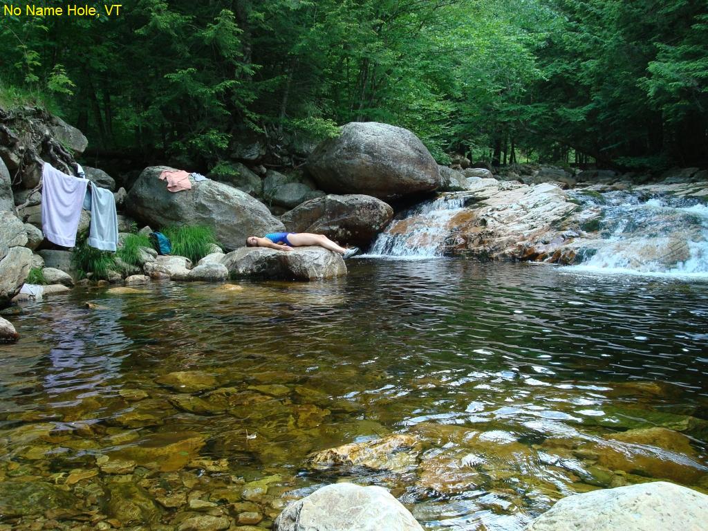
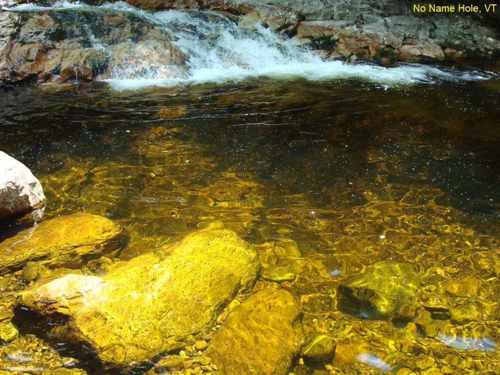
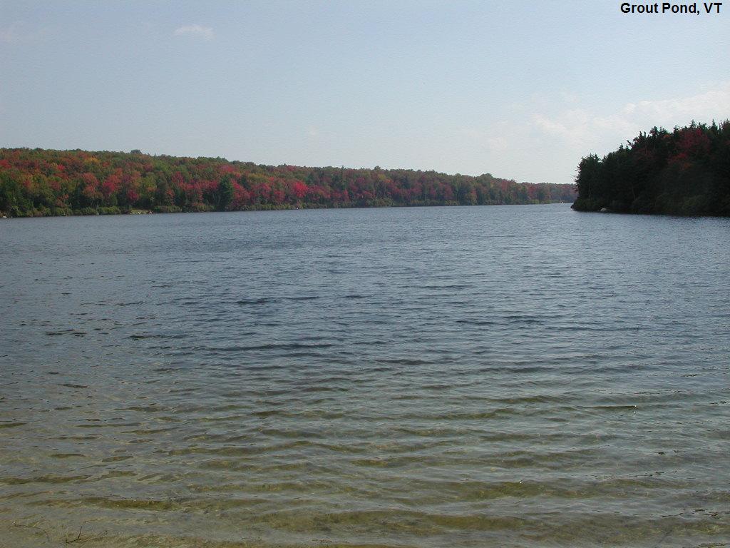
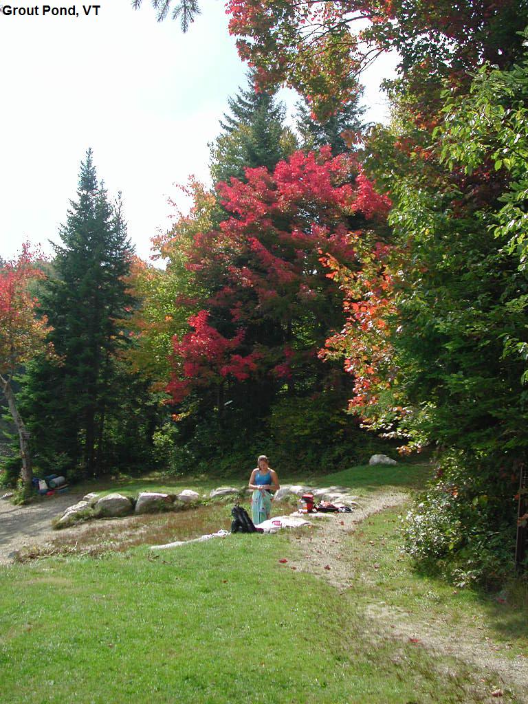
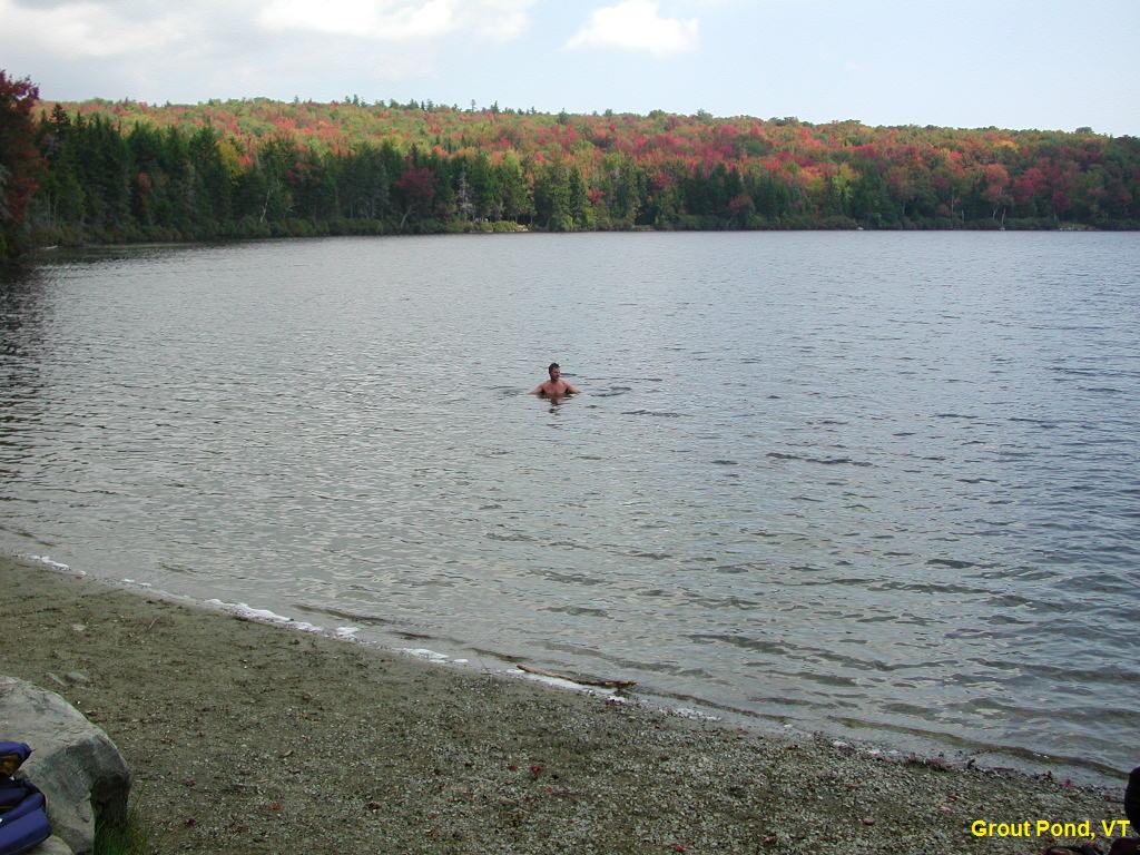
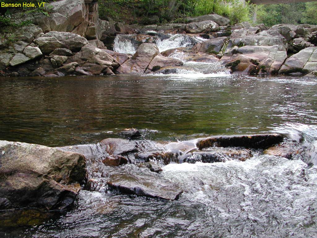
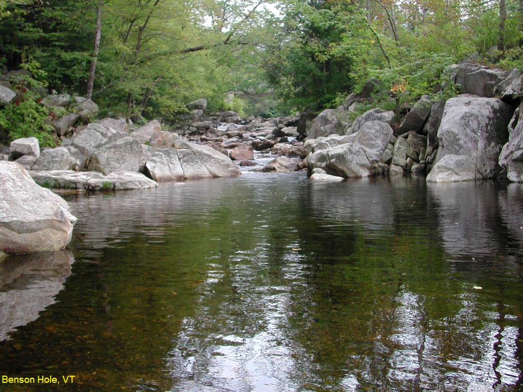
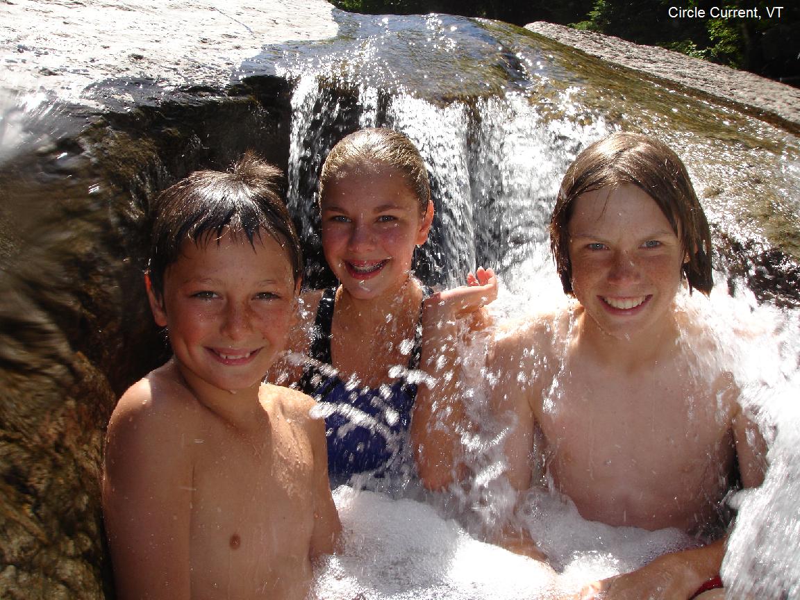
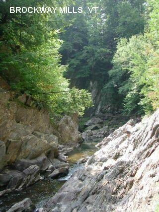
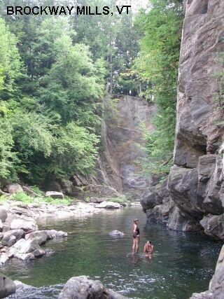
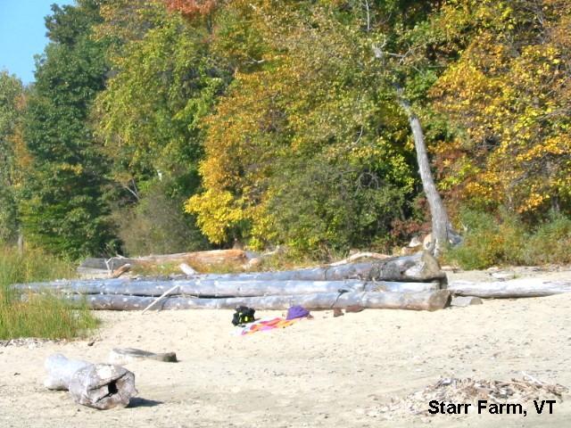
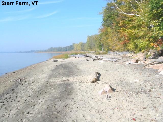
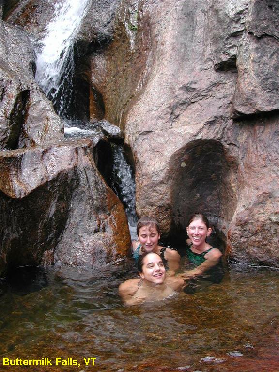
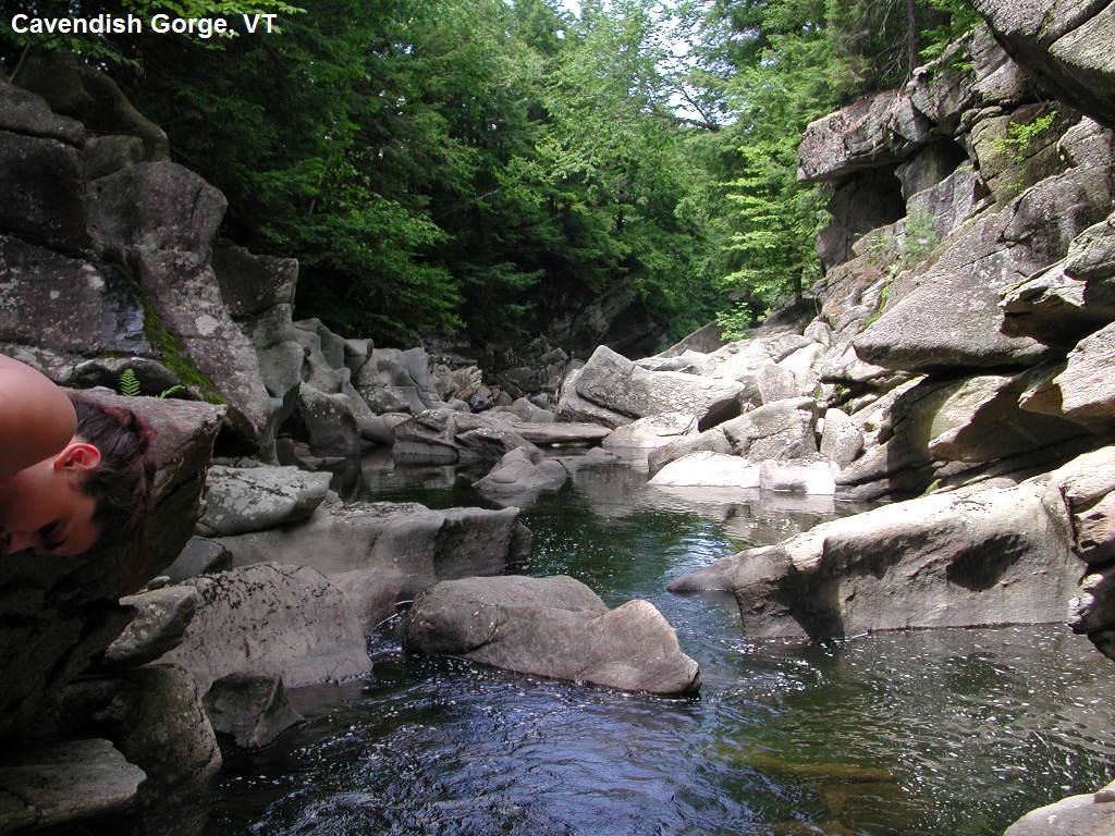
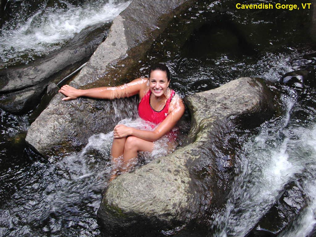
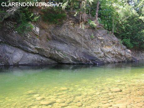
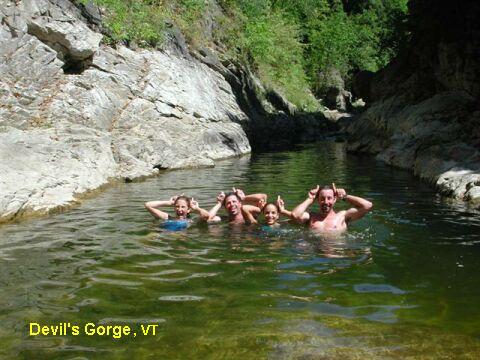
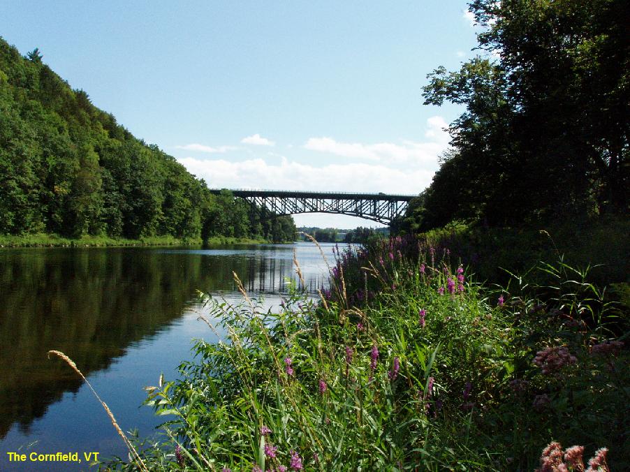
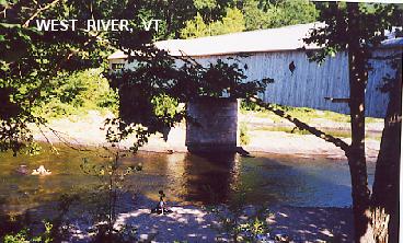
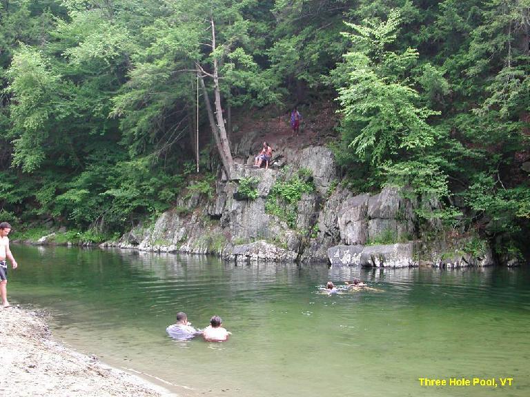
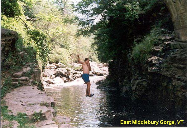
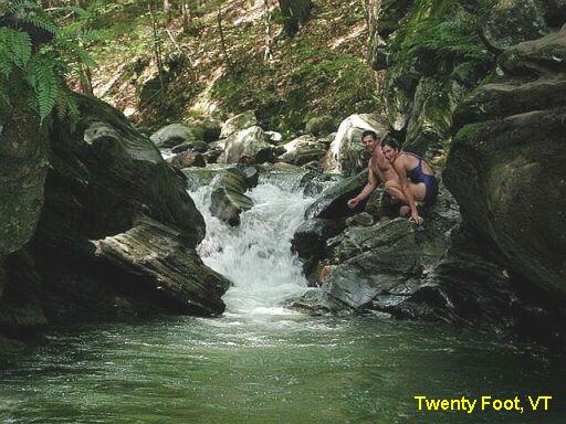
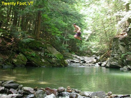
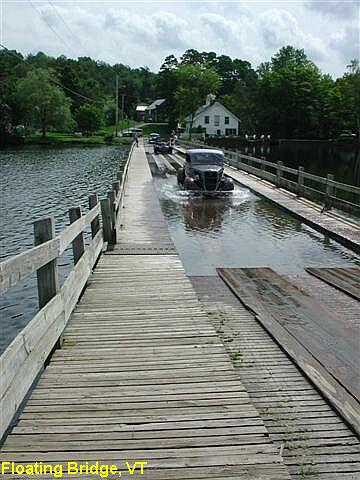
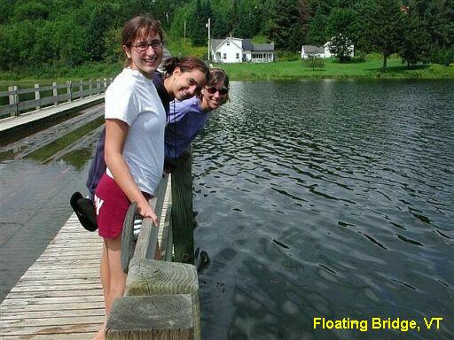
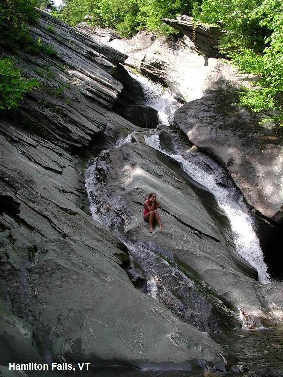
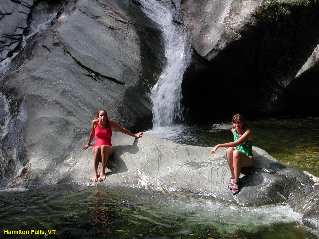
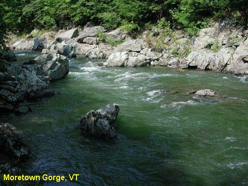
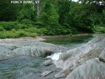
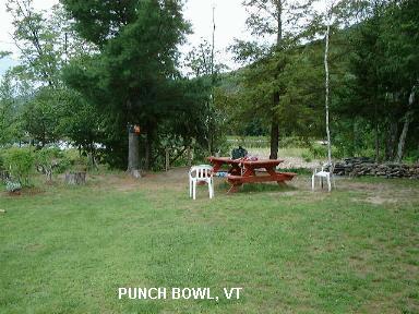
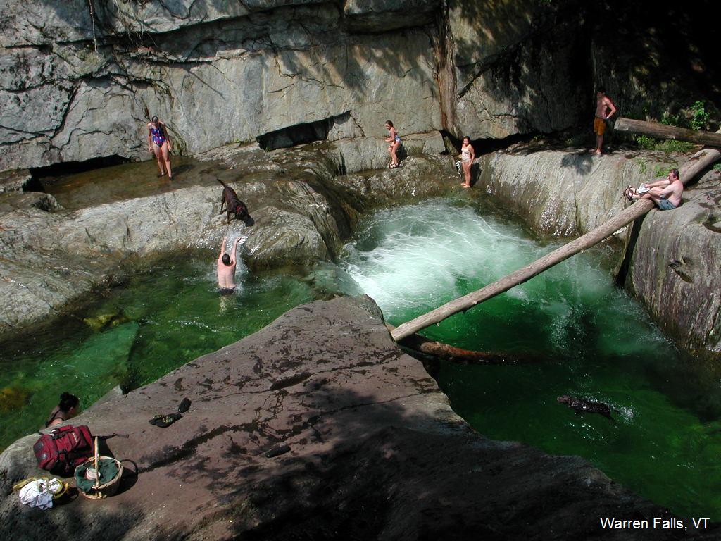
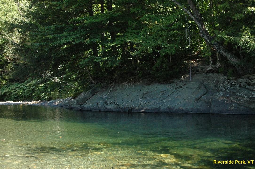
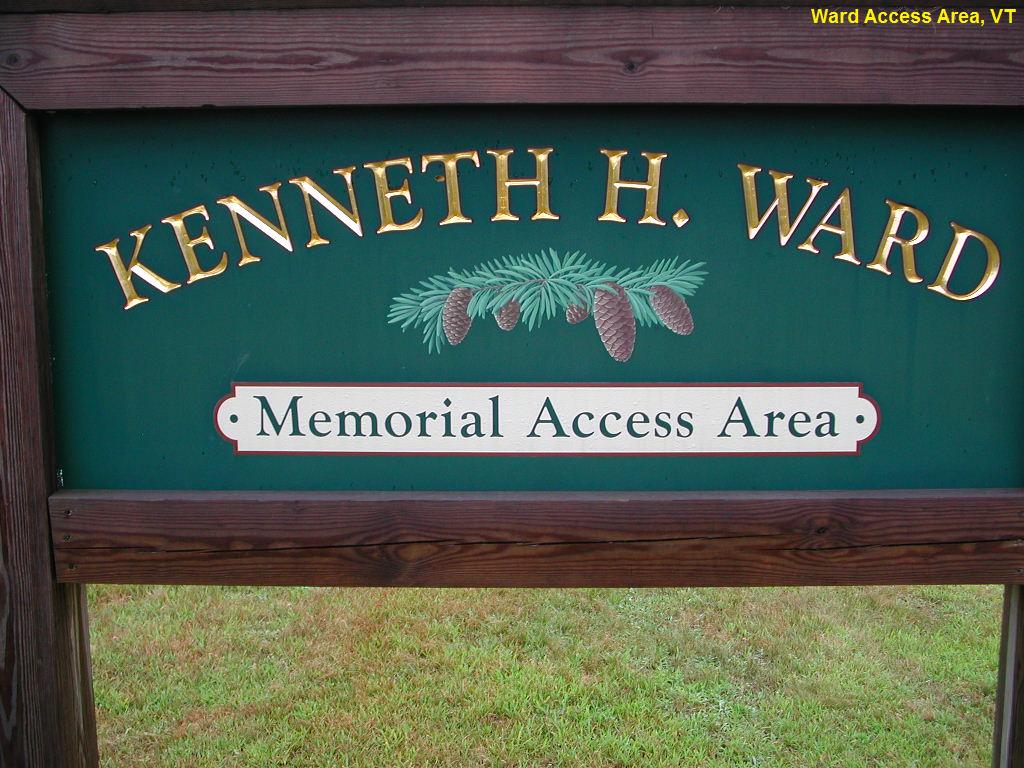
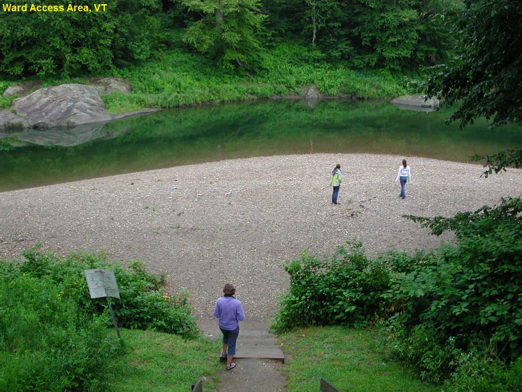
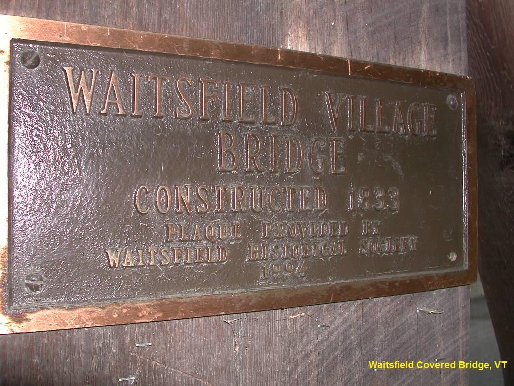
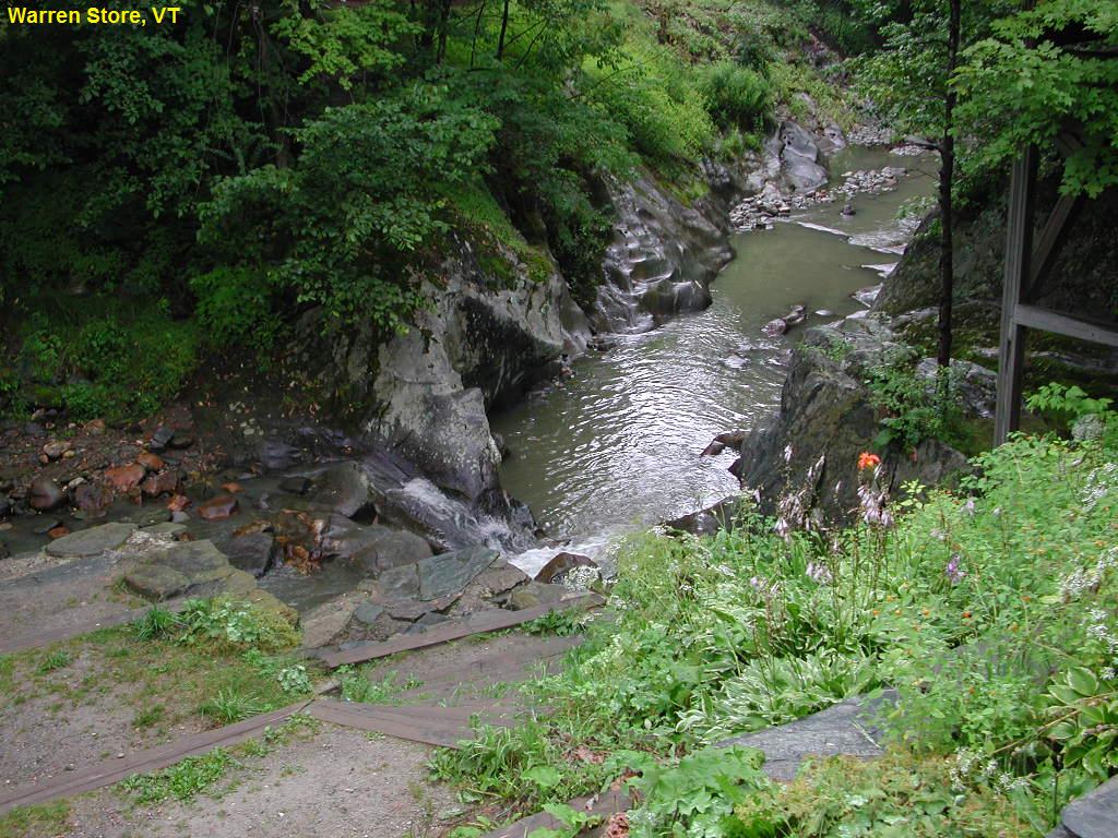
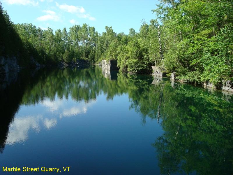
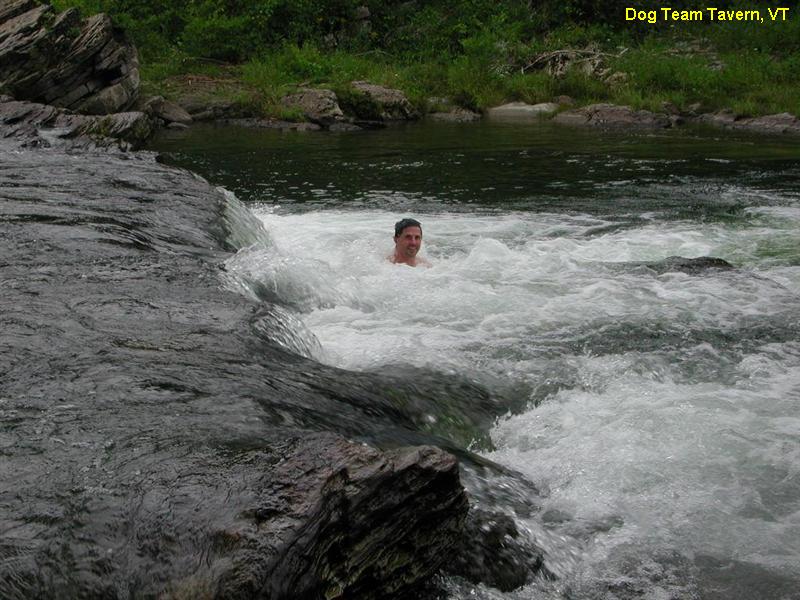
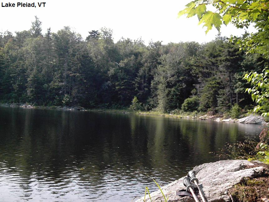
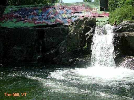
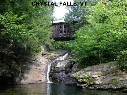
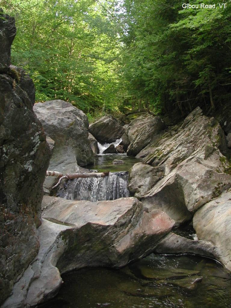
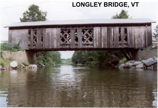
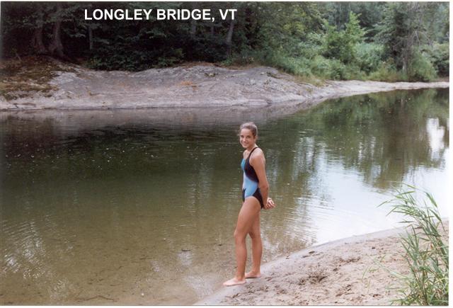
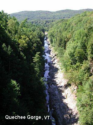
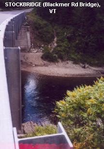
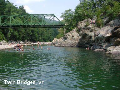
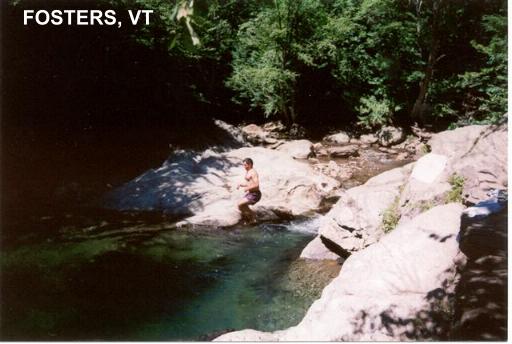
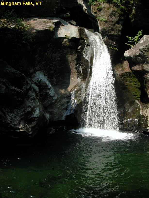
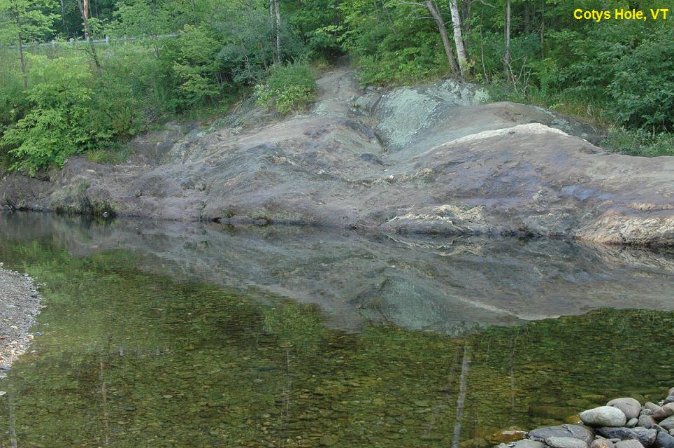
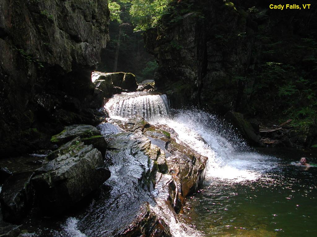
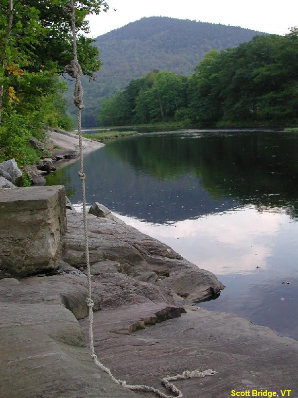
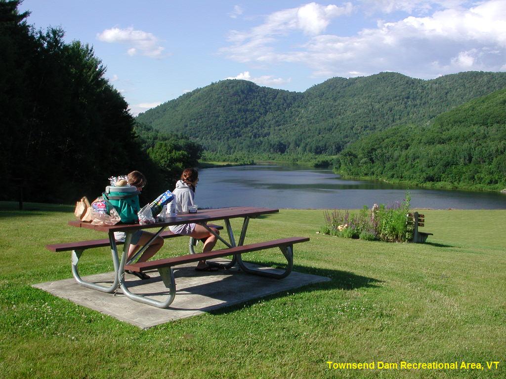
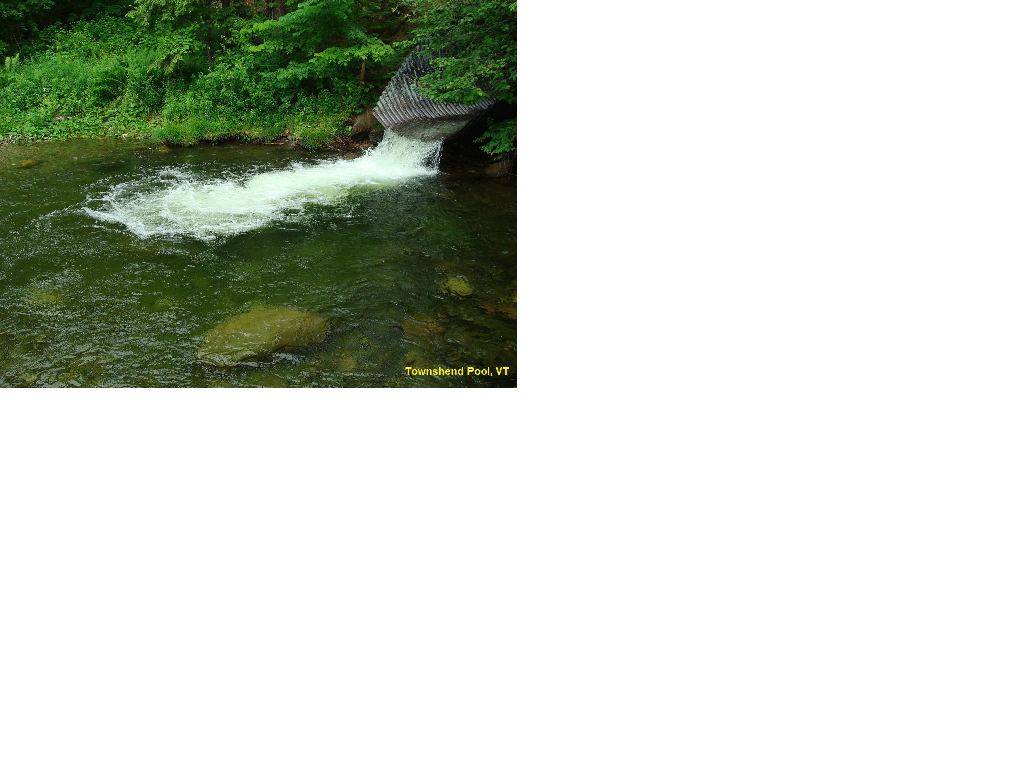
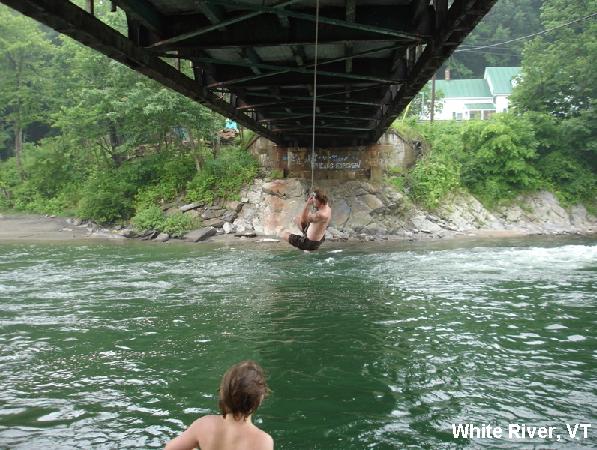