
OKLAHOMA SWIMMING HOLES |
|---|
Click here to see the home page and learn about swimming holes in other states
This swimming hole listing is by www.swimmingholes.org
BOY SCOUT HOLE |
TOWNS | TULSA, MUSKOGEE, TAHLEQUAH | LAT, LON | lat=35.85396, lon=-94.91700(source:map) (accuracy:approximate) | LINK TO GOOGLE MAP
STATE | OK |
WATER | Barron Fork Creek/Illinois River |
TYPE | Swimming hole in creek/river | DESCRIPTION | Long-time local swimming hole in creek/river named after nearby Boy Scout Camp Fred Darby. Nice family area to walk and explore junction of 2 rivers. WEB ARTICLE.
|
AREAS | Oklahoma-designated scenic streams |
SANCTION | Unofficial |
FEE | None |
FACILITIES |
None |
ACTIVITIES |
Swimming, jumping |
PHONE | Unknown |
CAMPING | Many campgrounds south of here on Tenkiller Lake. |
BATHING SUITS | Customary |
DIRECTIONS |
| From
Muskogee
follow US 62 to Tahlequah, then East from Tahlequah on HWY 62/51 across the
Illinois River bridge (~ 3miles East of town). Then about 1 mile further to
Speedy's Quick Stop on the right. Turn right and proceed about 4
miles to Welling. Just past the Fire Station and Post Office, turn
right on a paved road and go to the first gravel road. Turn left on
that gravel road and proceed to the end at the Boy Scout Hole.
CONFIDENCE | Pretty confident |
VERIFIED | No |
DATE UPDATED | 7/2018 | |
|---|
This swimming hole listing is by www.swimmingholes.org
GAGE ARTESIAN BEACH |
TOWNS | OKLAHOMA CITY, WOODWARD, GAGE | LAT, LON | lat=36.32139, lon=-99.74194(source:map) (accuracy:approximate) | LINK TO GOOGLE MAP
STATE | OK |
WATER | Artesian Spring |
TYPE | Lake/pool | DESCRIPTION | In 1917, drillers seeking oil hit instead an artesian spring with water high in magnesium. Now, with a sandy beach and bottom and concrete around the sides, the artesian source continues to supply water and it is open for public swimming. WEB INFO.
|
AREAS | Gage Artesian Beach, National Parks and Wildlife |
SANCTION | Official |
FEE | Unknown |
FACILITIES |
Unknown |
ACTIVITIES |
Swimming, jumping |
PHONE | Unknown |
CAMPING | No camping at site. |
BATHING SUITS | Required |
DIRECTIONS | From Woodward (northwest of Oklahoma City on RT 3) take 1st St. (RT 15) southwest toward Gage. As you come into Gage on 1st St., Artesian Beach Park will be on your right. |
CONFIDENCE | Very confident |
VERIFIED | No |
DATE UPDATED | 2/2014 | |
|---|
This swimming hole listing is by www.swimmingholes.org
LITTLE NIAGARA |
TOWNS | OKLAHOMA CITY, SULPHUR | LAT, LON | lat=34.50486, lon=-96.97151(source:map) (accuracy:approximate) | LINK TO GOOGLE MAP
STATE | OK |
WATER | Travertine Creek |
TYPE | Waterfall/pool | DESCRIPTION | The most well-known swimming hole at the park is Little Niagara, which is a travertine formation and the largest of the traditional swimming holes at the park. It is a very heavily visited park. In summer, if you come during the weekend, you'd better get there early. A good time to go during the summer is during the weekdays. If you walk east long the river you will find other, less crowded, swimming holes. CHICKASAW NRA WEB SITE (see map) .
|
AREAS | Chickasaw National Rec Area |
SANCTION | Unofficial |
FEE | none |
FACILITIES |
All facilities |
ACTIVITIES |
Swimming, jumping |
PHONE | unknown |
CAMPING | Developed camping at site, 6 campgrounds |
BATHING SUITS | Required |
DIRECTIONS | From Oklahoma City, go south on I-35 about 50 miles to Exit 55. Follow RT 7 east through Davis to Sulphur. (Pennington Creek Park, below, is near here also). In Sulphur, go south on RT 177 to the Chickasaw NRA - get map at visitor center. There may be more swimming holes than just at Little Niagara. |
CONFIDENCE | Very confident |
VERIFIED | No |
DATE UPDATED | 3/2011 | |
|---|
This swimming hole listing is by www.swimmingholes.org
PAWNEE BATH HOUSE WATER PARK |
TOWNS | OKLAHOMA CITY, SULPHUR | LAT, LON | lat=36.35868, lon=-96.80024(source:map) (accuracy:approximate) | LINK TO GOOGLE MAP
STATE | OK |
WATER | Pawnee Lake |
TYPE | Lake/Water Park | DESCRIPTION | Enjoy an old-fashioned swimming hole atmosphere at a city-owned lake and water park. An historic WPA bath house built in 1939 overlooks the swimming hole. This from News On 6 TV: "It was built to last, but closed in the 1970s, when people preferred the new city swimming pool in town. But that swimming pool was expensive to operate and maintain, so city leaders looked at reopening this historic site. The community raised $85,000 for improvements to the bath house, like electric and plumbing. The swimming area was cleaned up, and in 2003, the old favorite was new again." This is our kind of story! Has diving and sliding. WEB INFO & PHOTOS .
|
AREAS | Pawnee Bath House Water Park |
SANCTION | Official |
FEE | Small fee |
FACILITIES |
All facilities |
ACTIVITIES |
Swimming, jumping, diving, sliding |
PHONE | Unknown |
CAMPING | None at site |
BATHING SUITS | Required |
DIRECTIONS | From Tulsa, that RT 412 west about 47 miles then turn north (right) on RT 18 and go about 9 miles north to Pawnee. Stay on RT 18 through Pawnee (becomes 4th st. then Sewell Dr.) and about 2 miles north of Pawnee on RT 18 then bear left onto N3480 Rd. then left on Pawnee Lake Rd.. |
CONFIDENCE | Very confident |
VERIFIED | No |
DATE UPDATED | 2/2013 | |
|---|
This swimming hole listing is by www.swimmingholes.org
PENNINGTON CREEK PARK |
TOWNS | OKLAHOMA CITY, TISHOMINGO | LAT, LON | lat=34.23325, lon=-96.6826(source:map) (accuracy:approximate) | LINK TO GOOGLE MAP
STATE | OK |
WATER | Pennington Creek |
TYPE | Creek/Dam | DESCRIPTION | Beautiful in-town park and campground next to Pennington Creek. Close to historic Chickasaw Nation Capitol Museum and Genealogical Center and historic Johnston County Historical Society Museum. WEB INFO & PHOTOS .
|
AREAS | Pennington Creek Park & Campground |
SANCTION | Official |
FEE | Small fee |
FACILITIES |
All facilities |
ACTIVITIES |
Swimming |
PHONE | 580-371-2369 |
CAMPING | City campground at site Full hook-ups available, restrooms, showers | BATHING SUITS | Required | DIRECTIONS | From Oklahoma City, go south on I-35 about 70 miles to Exit 55 then take RT 7 east through Davis and Sulphur (Little Niagara swimming hole, above, is near Sulphur). Turn left where RT 7 joins RT 1. Keep straight on RT 1 where RT 7 turns east (left). Continue onto 3 RD St in Ravia. In Ravia, turn east (left) on Grand Ave. then bear right onto Wrecker Rd.. Continue east on Wrecker Rd. as it becomes RT 22. Stay on RT 22 as it winds around, crosses the river and enters Tishomingo. In Tishomingo, RT 22 becomes Main ST.. From Main ST. turn left on S. Capitol Ave, cross the river (again) and take the first left into the park. |
CONFIDENCE | Very confident |
VERIFIED | No |
DATE UPDATED | 2/2013 | |
|---|
This swimming hole listing is by www.swimmingholes.org
|
TOWNS | TULSA, SALINA |
STATE | OK |
WATER | Saline Creek |
TYPE | Creek/Spring |
DESCRIPTION | Swimming hole east of Tulsa in the area of Salina. For details, see "directions" below. |
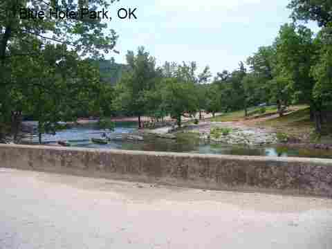
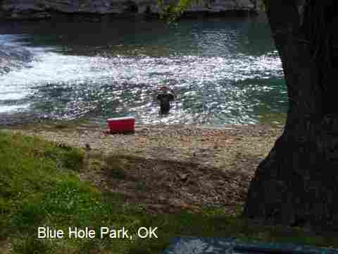
AREAS | Blue Hole Park |
SANCTION | Official |
FEE | Yes |
FACILITIES |
All facilities |
ACTIVITIES |
Swimming |
PHONE | 918-434-5507 |
CAMPING | At site |
BATHING SUITS | Required |
DIRECTIONS | From Tulsa, take RT 412 east (partial toll) across the Neosho River to Exit 6, go NORTH on RT 82, to Salina. Then: | BLUE HOLE PARK [BLUE]: Family-operated swimming hole fed by 3 springs of VERY cold water! Nice place for kids. No alcohol, food concession, camping and cabins on site. PHOTO , PHOTO , PHOTO . LAT, LON: lat=36.30268, lon=-95.0477(source:map) (accuracy: approximate) LINK TO GOOGLE MAP Official swimming - fee. Camping at site, also cabins, call for fees. Bathing suits required. To get here, in Salina, go east (right) on Kenwood Rd.. Stay on Kenwood Rd. (becomes E0508) as it winds around and go about 7 miles until you see the sign for Blue Hole Park. Very confident. Verified by another. Updated 10/2014.
CONFIDENCE | See above |
VERIFIED | See above |
DATE UPDATED | 2/2014 | |
|---|
This swimming hole listing is by www.swimmingholes.org
|
TOWNS | TULSA, PEGGS, OAKS |
STATE | OK |
WATER | Spring Creek |
TYPE | Creek |
DESCRIPTION | Spring Creek is natural, spring fed, very clear water around 70 degrees, east of Tulsa. It winds many miles, mostly bounded by private lands, and is shallow in some places. There are several public and (paid) private access points which are deep enough to swim. DO NOT TRESPASS ON PRIVATE PROPERTY. For details, see "directions" below. |
AREAS | Varies - see below |
SANCTION | Varies - see below |
FEE | Varies - see below |
FACILITIES |
Varies - see below |
ACTIVITIES |
Swimming |
PHONE | Varies - see below |
CAMPING | At Smokey Valley campground and Littlefields Campground (see below). |
BATHING SUITS | Customary |
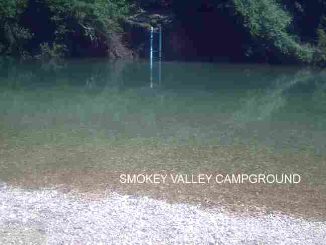
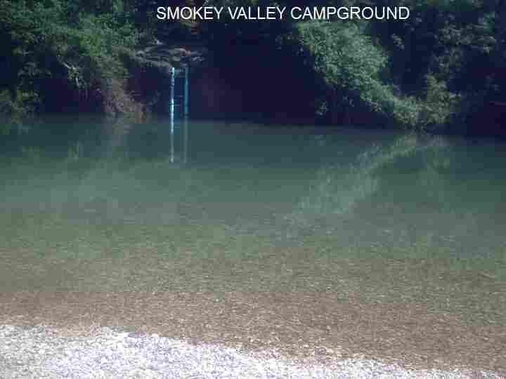
DIRECTIONS | From Tulsa, take RT 412 east (partial toll) across the Neosho River to Exit 6, go south on RT 82, then: | OLD TWIN BRIDGES [OLDT]: PRIVATELY OWNED swimming places in Spring Creek. Look for �swimming hole� signs and paid access points in this area. DO NOT TRESPASS ON PRIVATE PROPERTY. LAT, LON: lat=36.13105, lon=-95.1880(source:map) (accuracy: approximate) LINK TO GOOGLE MAP. To get here from RT 412 Exit 6, take RT 82 south about 3 miles then turn west (right) on Ear Bob Rd.. Go about 1.7 miles on Ear Bob Rd. then turn north (right) toward the bridge over Spring Creek. In the area of the bridge, look for �swimming hole� signs and paid access points in this area. DO NOT TRESPASS ON PRIVATE PROPERTY. Pretty confident. Not verified. Updated 10/2014. SMOKEY VALLEY CAMPGROUND [SMOK]: From the owner: "Beautiful campgrounds with amazing Fort Gibson Creek, family friendly, no glass bottles allowed in park. Bring your own food and coolers. Camping available on site. There are so many places to swim along the creek very easy to find a nice private area to swim, or you can swim upfront with a crowd of people and socialize". PHOTO , PHOTO , PHOTO . LAT, LON lat=36.129678, lon=-95.200911 (source: Campground Owner) (accuracy:approximate) LINK TO GOOGLE MAP. Camping at the site. Official swimming - fee to swim and camp. Bathing suits required. All facilities. To get here from Old Twin Bridges (above) continue north across the bridges then turn left on RT E0610 and follow it .5 miles until see Smokey Valley Campground signs will be on the left, just drive on up to front signs lead the way. Town is Locust Grove/Murphy. Very confident. Verified by another. Updated 10/2014. SPRING CREEK REC AREA [SCRA]: : A U.S. Army Corps of Engineers day-use area and boat ramp is located on Fort Gibson Lake where Spring Creek joins the Neosho River. At this point Spring Creek is basically an arm of the lake. LAT, LON: lat=36.11604, lon=-95.2474(source:map) (accuracy: approximate) LINK TO GOOGLE MAP. To get here from Smokey Valley Campground (above) ) continue west on E0610 Rd. (becomes N4830 Rd. then D0616 Rd.). At about 2 miles from Smokey Valley Campground turn south (left) on S 437 Rd. (becomes Spring Creek Rd then E0620 Rd.) and continue about 1.5 miles to the Spring Creek Army Corps Recreation Area. Very confident. Not verified. Updated 10/2014. RIP RAP ACCESS [RIPR]: PUBLIC swimming place (Army Corps of Engineers land) in Spring Creek where the Corps placed rip rap (a rock bank) to lessen erosion. LAT, LON: lat=36.12723, lon=-95.1937(source:map) (accuracy: approximate) LINK TO GOOGLE MAP. To get here, go back to Ear Bob Rd. and continue west on Ear Bob Rd.. About a half mile past (west of) the turn off for the Old Twin Bridges, turn north (right) on N4390 Rd. and park off the north side of the road near the creek where past flooding required a build-up of rip-rap. Walk across the road and the rocks to enter the creek where it crosses into U.S. Army Corps of Engineers land (do not enter the private Cedar Crest community downstream). Pretty confident. Not verified. Updated 10/2014. LITTSLEFIELDS CAMPGROUND [LITT]: Private campground. Fee to swim and/or to camp. No glass. Clothing optional. Rope swing, diving platform. Porta pots. To get here, go back to RT 82 at Ear Bob Rd. and continue south on RT 82 about 4.5 miles from Ear Bob Rd.. Then turn east (left) onto RT 640, go to stop sign and turn left, road will turn into dirt road, go down hill, before low water bridge turn right and you are there. There may also be public access to Spring Creek at the low water crossing here, known as "Cave Springs". LAT, LON: lat=36.10404, lon=-95.09633(source:Map) (accuracy: approximate) LINK TO GOOGLE MAP. Pretty confident. Verified by another. Updated 10/2014. OLD ROCKY FORD S. P. [OLDR]: Old state park no longer functioning as such but with a short section of public access to Spring Creek and swimming opportunities. Also called "Little Blue Hole". No facilities, no camping. Clothing optional. Rope swing, diving platform. Porta pots. To get here, go back to RT 412 east (toll road) then at Exit 17 get off the toll road and take ALT 412 east then turn south (right) on RT 412A (33C) to Oaks. In Oaks, turn right (west) on RT 82A (E0590 Rd) and go about 1.5 miles to where 82A crosses the creek. The Little Blue Hole is on the right side of the road as you cross the creek. LAT, LON: lat=36.13943, lon=-94.9156 (source:Map) (accuracy: approximate) LINK TO GOOGLE MAP. Pretty confident. Not verified. Updated 10/2014.
CONFIDENCE | See above |
VERIFIED | See above |
DATE UPDATED | 10/2014 | |
|---|
This swimming hole listing is by www.swimmingholes.org
TURNER FALLS |
TOWNS | OKLAHOMA CITY, SULPHUR | LAT, LON | lat=34.42947, lon=-97.14636(source:DeLorme) (accuracy:exact) | LINK TO GOOGLE MAP
STATE | OK |
WATER | Honey Creek |
TYPE | Waterfall | DESCRIPTION | Turner Falls is the largest falls in Oklahoma, most majestic, with a large pool of clear water at the bottom for swimming. There is a large rock at the bottom for jumping and you can swim around behind the falls too. There are caves to explore in the falls also. In the park, near the entrance, is another natural swimming place with diving boards and slides. TURNER FALLS PARK WEB SITE.
|
AREAS | Turner Falls Park, Arbuckle Mountains |
SANCTION | Official |
FEE | Yes, see web site above |
FACILITIES |
All facilities |
ACTIVITIES |
Swimming, jumping, diving |
PHONE | 580-369-2917 |
CAMPING | None at site |
BATHING SUITS | Required |
DIRECTIONS | From Oklahoma City, go south on I-35 about 50 miles to Exit 51. Follow RT 77 south Turner Falls. |
CONFIDENCE | Very confident |
VERIFIED | No |
DATE UPDATED | 4/24/2005 | |
|---|
HOME