See a SLIDESHOW of swimming hole photos in these states.
This swimming hole listing is by
www.swimmingholes.org
FAYWOOD HOT SPRINGS
(FAYW)
|
|
TOWNS | EL PASO (TX), SILVER CITY, LAS CRUCES, FAYWOOD
|
|---|
|
LAT, LON | lat=32.5542488, lon=-107.9942024(source: map) (accuracy:approximate)
LINK TO GOOGLE MAP|
STATE | NM |
|---|
|
WATER | Hot Spring |
|---|
|
TYPE | Hot Spring |
|---|
|
DESCRIPTION | This wonderful, commercial hot springs facility has been recently (2012) reopened by Damon and Stephanie Shirk. Give them a visit - you will enjoy! Here is a description from their web site: "Faywood Hot Springs, a rustic natural geothermal resort in southwestern New Mexico, has many outdoor public and private soaking pools for those who wish to partake of its healthful and rejuvenating mineral water baths. There are separate clothing-required, clothing-optional (naturist), private and group bathing areas. There are tent sites for camping, pull through RV (recreational vehicle) sites with full hook ups, and private cabins for overnight lodging accommodations. Our new Visitor's Center will house a cafe, museum and gift shop." |
|---|
|
AREA | None |
|---|
|
SANCTION | Official |
|---|
|
FEE | Yes, day use fee and overnight fee |
|---|
|
FACILITIES |
All facilities |
|---|
|
ACTIVITIES |
Hot Soaking |
|---|
|
PHONE | 575-536-9663 |
|---|
|
CAMPING | Camping at site, also cabins |
|---|
|
BATHING SUITS | Optional |
|---|
|
DIRECTIONS | 165 Highway 61, HC 71 Box 1240, Faywood, NM 88034. See their web site: for directions.
|
|---|
|
CONFIDENCE | Very confident |
|---|
|
VERIFIED | Yes |
|---|
|
DATE UPDATED | 8/10/2012 |
|---|
|
|---|
|
|---|
This swimming hole listing is by
www.swimmingholes.org
JEMEZ SPRINGS AREA
[5 PLACES]
(JEME)
|
|
TOWNS | ALBUQUERQUE, LOS ALAMOS, JEMEZ SPRINGS |
|---|
|
STATE | NM |
|---|
|
WATER | Varies, see below |
|---|
|
TYPE | Swimming holes and hot springs |
|---|
|
DESCRIPTION | Drive a little and enjoy a lot! These are all north of Albuquerque and west of Santa Fe and Los Alamos. If you come from Los Alamos, you will enjoy a very scenic road, RT 4, between Los Alamos and Jemez Springs (also called the "Jemez Mountain Trail"). Be sure to look at the astounding Valles Caldera National Preserve on RT 4, one of the largest remnants of a volcanic caldera in the world. These swimming places are hot, cold and in between. (I am told that the hot ones were already hot long BEFORE the atomic research at Los Alamos.) There are places where, driving on RT 4, you can smell the sulfur of the thermal springs in the air. See DIRECTIONS below for details.
|
|---|
|
AREA | Santa Fe N.F. |
|---|
|
SANCTION | Unofficial |
|---|
|
FEE | None |
|---|
|
FACILITIES |
None |
|---|
|
ACTIVITIES |
Hot soaking, Swimming |
|---|
|
PHONE | None |
|---|
|
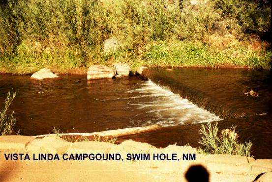
CAMPING | There are a number of campgrounds along RT 4 in the Santa Fe N.F.. My favorite is Vista Linda campground, south of Jemez Springs on RT 4. I believe there is a swimming hole in the campground behind site #8 PHOTO . |
|---|
|
BATHING SUITS | Forest rules say "No nudity" but this is often not observed. |
|---|
|
DIRECTIONS | From Santa Fe, take RT 285 north to RT 4 west to White Rock. Then:
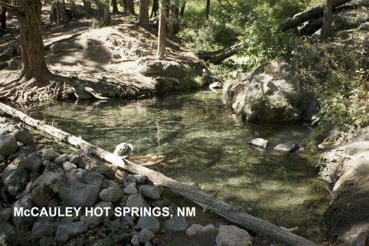
MC CAULEY WARM SPRINGS [MCCA]: Deep in the Santa Fe National Forest, McCauley is a beautiful warm springs, about 85 degrees, and a very nice hike on Trail #137 about 1.5 miles each way. There are several pools, some very large, with perfectly clear water, in a very scenic glade. PHOTO. LAT, LON :lat=35.8202, lon= -106.6274(source: Soak.net files) (accuracy:exact) LINK TO GOOGLE MAP. Verified (Jemez Falls route only), 9/02. Very confident. There are two ways to get here:
First way: (this is said to be the easier trail), from RT 4 west of White Rock and Los Alamos, see the signs for the Jemez Falls Recreation Area and campground. Park here and hike toward Jemez Falls a very short distance where you will see a trail marker indicating the trail forking off to McCauley Warm Springs (this is Trail #127). Follow this trail about 1.5 miles to the warm springs.
Second way: Continuing west then south on RT 4 (past RT 126 and past the parking area for Spence Hot Springs, see below) come to Battle Rock Picnic Area. Park here (you can park in a little lot just north of the picnic area itself to avoid paying the fee for the picnic area) and find Trail #127 and follow it up a long, gradual grade about 1.5 miles to the warm springs. (I suppose if you had 2 cars you could leave one at Battleship Rock and hike down from Jemez Falls about 3.5 miles total and visit the warm springs on the way.)
SAN ANTONIO HOT SPRINGS [SANA]: Also deep in the Santa Fe National Forest but 5 miles up a very rough road (road may be closed) (road will require a high clearance vehicle), San Antonio is a spectacular hot springs, with about 4 rock pools down the side of a mountain overlooking a scenic valley and with a very large flow of clear, hot water. This is a primo hot springs! PHOTO. LAT, LON :lat=35.9383, lon= -106.6454(source: Soak.net files) (accuracy:exact) LINK TO GOOGLE MAP Verified, 9/02. Very confident. To get here, go west on RT 4 from Jemez Falls, then turn west (left) onto RT 126. Follow RT 126 a few miles to where FR 376 (see sign) comes in from the left. (FR 376 continues across RT 126 but there is no sign on the right side.) Go right here on FR 376 past a gate (gate may be closed) up a very rocky, rough road (that doesn't get very much smoother as you go up it further). If your vehicle can make this road and the road is open, it is about 5 miles to where the road drops down into a small valley and clearing past 2 cabins on the right (where you may see cars parked). Park then walk across a wooden bridge and take a short but steep climb up to the springs on the right.
If you can't get your vehicle up this road or if the road is closed, you can hike the 5 miles up the road (easy, level hike), but you are supposed to be out by sunset. (I hitchhiked up this road in 9/02 as I didn't have a high clearance vehicle. There is not much up here but the hot springs and folks may pick you up rather quickly.) It is a great hot springs, worth finding a way up! Verified, 9/02. Very confident
SPENCE HOT SPRINGS [SPEN]: Spence Hot Springs is a very well-used, sometimes a rowdy crowd, but a large and beautiful hot spring, an easy walk from the road. LAT, LON :lat=35.8489, lon= -106.6297(source: Soak.net files) (accuracy:exact) LINK TO GOOGLE MAP Verified, 9/02. Very confident. To get there: Continue west on RT 4 past RT 126 about 1.5 miles see the sign "Dark Canyon Fishing Area" and, just past here, there is a very large parking area on the left with no large sign. (Not as far as Battleship Rock) Park in this lot, where you will see a small sign that says "Parking sunrise to sunset-No nudity". From here, follow the well used trail a short distance across the creek to the hot springs.
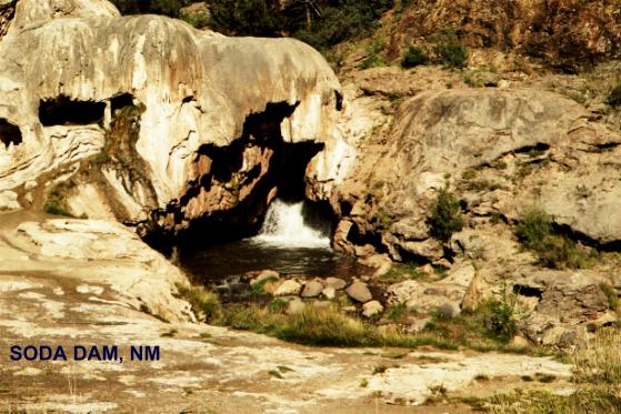
SODA DAM [SODA]: Soda Dam was formed in the Jemez River where minerals from a natural spring made a dam that blocks the J�mez River. Through a hole in the dam, the river forms a waterfall. The spot below the falls is a popular swimming hole. PHOTO. LAT, LON :lat=35.7931, lon= -106.6858(source: Soak.net files) (accuracy:exact) LINK TO GOOGLE MAP Verified, 9/02. Very confident. To get here: continue west (really south) on RT 4 toward Jemez Springs to a sign that says "Jemez State Monument 2 miles" then in another mile come to a large white formation that crosses RT 4 - this is the soda dam. There is a parking area just past the dam on the left. The waterfall and swimming hole are very visible from here. (The Bath House in J�mez Springs has natural hot mineral baths and massages. Fee charged. )
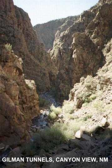
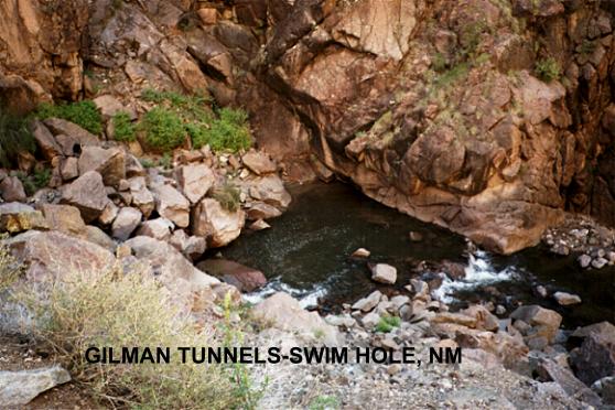
GILMAN TUNNELS[GILM]: The Gilman Tunnels are 2 roadway tunnels in spectacular solid rock cliffs towering above the Guadalupe River. Well worth seeing just to see the canyon and river, there appear to be several swimming places here also. PHOTO , PHOTO . To get here: continue west (really south) on RT 4 beyond Jemez Springs and the Linda Vista Campground and turn west (right) on RT 485. Follow this road along the Guadalupe River through the 2 Gilman Tunnels. Right after you clear the second tunnel, pull off in the parking area on the right. It appears that you easily can climb down here to the river and there is a deep pool for swimming. Also, if you continue on this road to the gate (where it becomes unpaved) just past the gate on the right is a very accessible rock ledge over the water with an apparent swimming place. LAT, LON :lat=35.71978, lon= -106.75886(source: DeLorme) (accuracy:general area) LINK TO GOOGLE MAP Very confident. Verified 9/02. Updated 12/17/2007.
|
|---|
|
CONFIDENCE | Very confident |
|---|
|
VERIFIED | Mostly, see above |
|---|
|
DATE UPDATED | 9/28/2002 |
|---|
|
|---|
This swimming hole listing is by
www.swimmingholes.org
MONTEZUMA HOT SPRINGS
(MONZ)
|
|
TOWNS | LAS VEGAS, MONTEZUMA
|
|---|
|
LAT, LON | lat=35.65350, lon=-105.29413(source: map) (accuracy:approximate)
LINK TO GOOGLE MAP|
STATE | NM |
|---|
|
WATER | Hot Spring |
|---|
|
TYPE | Hot Spring |
|---|
|
DESCRIPTION | Several natural hot springs on the side of a hill, with rock and cement tubs, various temperatures. Originally part of the historic Montezuma Castle Resort, now accessible to the public - no fee. SOME HISTORY ON THE WEB. Now on the property of the United World College, they tens to be clean and users orderly. Please don't be the exception! |
|---|
|
AREA | United World College |
|---|
|
SANCTION | Unofficial |
|---|
|
FEE | No |
|---|
|
FACILITIES |
None |
|---|
|
ACTIVITIES |
Hot Soaking |
|---|
|
PHONE | None |
|---|
|
CAMPING | No camping at site |
|---|
|
BATHING SUITS | Required |
|---|
|
DIRECTIONS | From Las Vegas, NM, go approx. 6 miles northwest on NM 65. Watch for signs on the right side of the road near the Armand Hammer United World College of the American West.
|
|---|
|
CONFIDENCE | Very confident |
|---|
|
VERIFIED | No |
|---|
|
DATE UPDATED | 10/2014 |
|---|
|
|---|
|
|---|
This swimming hole listing is by
www.swimmingholes.org
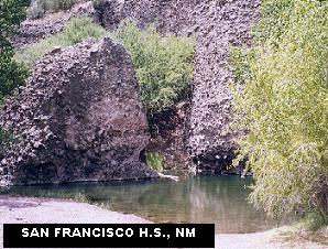
SAN FRANCISCO HOT SPRINGS
(SANF)
|
|
TOWNS | LAS CRUCES, SILVER CITY, GLENWOOD
|
|---|
|
LAT, LON | lat=33.244, lon=-108.88(source: web site) (accuracy:exact)
LINK TO GOOGLE MAP|
STATE | NM |
|---|
|
WATER | Unknown |
|---|
|
TYPE | Hot Spring |
|---|
|
DESCRIPTION | A huge hot spring, you can swim laps in this pool, and the setting is
very scenic as well. It is about a 45 minute hike to this gem; bring a lunch and stay a while. It
used to be easier to get to and attracted a sometimes messy crowd; now it is quite pristine and not
very populated. |
|---|
|
AREA | Gila N.F. |
|---|
|
SANCTION | Unofficial |
|---|
|
FEE | None |
|---|
|
FACILITIES |
None |
|---|
|
ACTIVITIES |
Hot Soaking and Swimming |
|---|
|
PHONE | (505)539-2481 (Glenwood Ranger Station) |
|---|
|
CAMPING | No camping at site, primitive camping elsewhere in N.F. Established
camping at Cottonwood campground, further north on RT 180. |
|---|
|
BATHING SUITS | Optional (very) |
|---|
|
DIRECTIONS | From Silver City, take RT 180 NW. As you approach Glenwood,
see the Glenwood Ranger Station on the left (west) side of road. STOP AT THE RANGER
STATION and ask about access to San Francisco Hot Spring. They will tell you where to park
and how to hike to the hot spring. Access sometimes changes so it is best always to ask.
|
|---|
|
CONFIDENCE | Very confident |
|---|
|
VERIFIED | Yes |
|---|
|
DATE UPDATED | 1/4/2000 |
|---|
|
|---|
|
|---|
This swimming hole listing is by
www.swimmingholes.org
SANTA ROSA
(SANR)
|
|
TOWNS | ALBUQUERQUE, TUCUMCARI, SANTA ROSA |
|---|
|
LAT, LON | lat=34.94058, lon=-104.67878(source: DeLorme) (accuracy:exact)
LINK TO GOOGLE MAP |
|---|
|
STATE | NM |
|---|
|
WATER | Spring |
|---|
|
TYPE | Spring/pond |
|---|
|
DESCRIPTION | Santa Rosa is known as the city of lakes, clear lakes and scuba diving. There is a beautiful spring fed pond in middle of Santa Rosa town in a public (free!) municipal park, complete with a diving board. It is absolutely lovely and very clean. Definitely a highlight. SANTA ROSA WEB SITE.
|
|---|
|
AREA | None |
|---|
|
SANCTION | Official |
|---|
|
FEE | None |
|---|
|
FACILITIES |
Unknown |
|---|
|
ACTIVITIES |
Swimming, Diving |
|---|
|
PHONE | Unknown |
|---|
|
CAMPING | Unknown |
|---|
|
BATHING SUITS | Customary |
|---|
|
DIRECTIONS | From Albuquerque, take I-40 east to Santa Rosa (Exit 275). Take RT 54 toward town, turn left at the Motel 6 and drive all the way to the back of the park. |
|---|
|
CONFIDENCE | Pretty confident |
|---|
|
VERIFIED | No |
|---|
|
DATE UPDATED | 10/6/2004 |
|---|
|
|---|
This swimming hole listing is by
www.swimmingholes.org
SITTING BULL FALLS
(SITT)
|
|
TOWNS | CARLSBAD |
|---|
|
LAT, LON | lat=32.24522, lon=-104.69636(source: DeLorme) (accuracy:exact)
LINK TO GOOGLE MAP |
|---|
|
STATE | NM |
|---|
|
WATER | Sitting Bull Springs |
|---|
|
TYPE | Falls |
|---|
|
DESCRIPTION | NOTE: Closed for renovation 'till spring 2015
Sitting Bull Falls is an oasis in the desert - a Forest Service recreation area (picnicking, hiking, no camping). It has nice swimming holes below and above the falls. Swimming is not permitted at the pools below the falls - this is enforced. Do not enter this area after closing time, you can get a large trespassing ticket. WEB SITE.
|
|---|
|
AREA | Lincoln N. F. |
|---|
|
SANCTION | Unofficial |
|---|
|
FEE | Yes |
|---|
|
FACILITIES |
Toilets, tables |
|---|
|
ACTIVITIES |
Picnicking, hiking, swimming |
|---|
|
PHONE | 575-434-7200 (Forest Service Office) |
|---|
|
CAMPING | None at site |
|---|
|
BATHING SUITS | Required |
|---|
|
DIRECTIONS | From Carlsbad, go about 50 miles west on RT 137. Then turn west (left) and go 8 miles on Sitting Bull Falls Road. |
|---|
|
CONFIDENCE | Very confident |
|---|
|
VERIFIED | By another, 8/2014 |
|---|
|
DATE UPDATED | 8/2014 |
|---|
|
|---|
This swimming hole listing is by
www.swimmingholes.org
TAOS AREA
[2 PLACES]
(TAOS)
|
|
TOWNS | SANTA FE, TAOS, ARROYO HONDO |
|---|
|
STATE | NM |
|---|
|
WATER | Hot Springs/Rio Grande River |
|---|
|
TYPE | Hot Springs/Rio Grande River |
|---|
|
DESCRIPTION | West of Taos and Southwest of Arroyo Hondo is the Rio Grande River canyon. At the bottom of this beautiful desert canyon is the Rio Grande River also some great hot springs to soak in right on the banks of the river. (At high river flows, these may be under water.) You can soak in the springs and cool off in the river (if the river flow is low enough for this to be SAFE) See DIRECTIONS below for details.
|
|---|
|
AREA | BLM area |
|---|
|
SANCTION | Unofficial |
|---|
|
FEE | None |
|---|
|
FACILITIES |
None |
|---|
|
ACTIVITIES |
Hot soaking, Bathing |
|---|
|
PHONE | None |
|---|
|
CAMPING | No developed camping at site. Primitive camping may be allowed. |
|---|
|
BATHING SUITS | Optional |
|---|
|
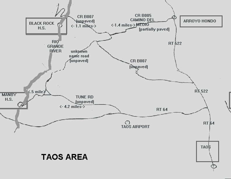
DIRECTIONS | (SEE LOCAL AREA MAP ABOVE) From Taos head north on RT 64, then follow the map and the directions below.
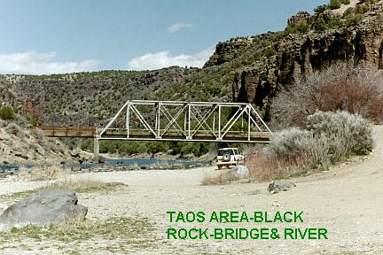
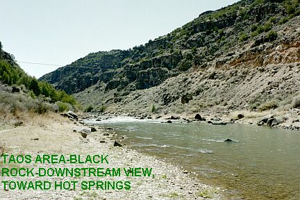
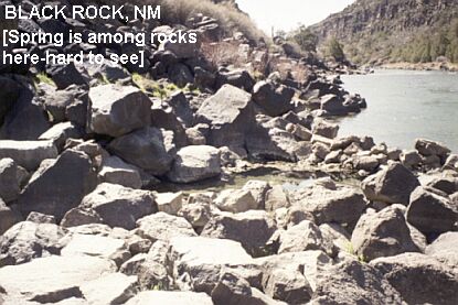
BLACK ROCK HOT SPRINGS[BLAC]: Hot springs with rugged rocks all around but nice sand bottom and 97 degree water. Some algae in the spring, but no sulphurous smell and clear water. Right by the banks of the Rio Grande at the bottom of a spectacular canyon. Scenic beauty worth the drive down here even if you don't take a dip. PHOTO , PHOTO , PHOTO . May be flooded at high water; otherwise can cool off in the river. There is a sandy beach on the river on the east side of the bridge (before you cross.) LAT, LON :lat=36.5283, lon= -105.7126(source: Soak.net files) (accuracy:exact) LINK TO GOOGLE MAP.
In 2008 we received this cautionary note from a local:" I heard more than a few stories about some not so desirable type people who hung out, harassed and threatened others. I don't remember the exact incidents, but this is an area actually considered dangerous, at times, because of the low lifes, who would go there with the potential for violence to occur. I would recommend going in groups of at least two or more." May be best to go over to Manby (below) instead?
To get here: Best way to get here is from town of Arroyo Hondo (SEE LOCAL AREA MAP ABOVE.) From Taos go north on RT 64 then north on RT 522 to Arroyo Hondo. In Arroyo Hondo, at the bottom of the hill, turn go southwest (left) on CR B005 (signed) (also named Camino Del Medio but not signed with this name). Follow this partially paved road as it winds around for 1.4 miles. Then turn west (right) on the unsigned, unpaved CR B007. Follow this road about 1.1 miles to a bridge crossing the Rio Grande River. After crossing the river, there is a small parking area at the end of the first switchback as you go up the west side of the canyon. Park here and follow the trail for about 10 minutes downstream to the hot spring. (Drive back the same way you came- do not try to continue on the road on the west side of the canyon- it is very long and sometimes very rough). Verified 4/2003. Very confident.
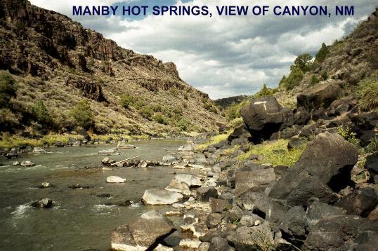
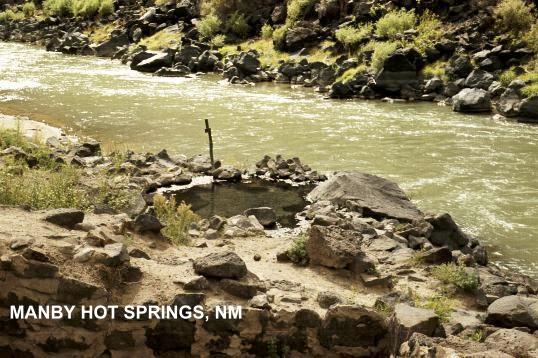
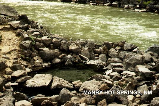
MANBY HOT SPRINGS[MANB]: Hot springs with two pools and nice sand bottom. (One pool is obvious when you get there, a smaller but perhaps warmer one is behind the stone wall of an old building that used to be there.) Right on the banks of the Rio Grande at the bottom of the canyon at an old stagecoach crossing. Nice hike down on gradual grade where old stagecoach road used to be. May be flooded at high water; otherwise can cool off in the river. PHOTO , PHOTO , PHOTO . LAT, LON :lat=36.5072, lon= -105.7229(source: Soak.net files) (accuracy:exact) LINK TO GOOGLE MAP.
To get here: From Taos go north on RT 64 (SEE LOCAL AREA MAP ABOVE) and continue on RT 64 to the Taos Airport. Roughly across RT 64 from the airport see the signed "Tune Rd.". Take Tune Rd. north (right) and don't take any turn offs until about 4.2 miles where the road forks, keep left here. Continue about .5 miles more to the parking area at edge of canyon and walk about .5 miles down the old wagon road the leaves from the left side of the parking area. (see local area map.) Verified, 9/02. Very confident.
|
|---|
|
CONFIDENCE | Very confident |
|---|
|
VERIFIED | Yes |
|---|
|
DATE UPDATED | 4/13/2003 |
|---|
|
|---|
HOME/
|
