This swimming hole listing is by
www.swimmingholes.org
BEARD CREEK
(BEAR)
|
|
| TOWNS |
HILLSBORO, KEENE |
| STATE |
NH |
| WATER |
Beard Creek |
| TYPE |
Creek |
| DESCRIPTION |
Dammed spot on the creek. Grassy beach,
never crowded.
|
| AREAS |
None |
| SANCTION |
Unknown |
| FEE |
Unknown |
| FACILITIES |
Unknown |
| ACTIVITIES |
Swimming |
| PHONE |
Unknown |
| CAMPING |
Unknown |
| BATHING
SUITS |
Unknown |
| DIRECTIONS |
Take RT 9 west out of Hillsboro, toward
Keene. Turn north on Beard Rd.
opposite the Sampan restaurant. The swimming hole is about 1 mi on the
left. |
| CONFIDENCE |
Uncertain |
| VERIFIED |
No |
| DATE
UPDATED |
9/30/1999 |
This swimming hole listing is by
www.swimmingholes.org
CAMPTON AREA
[3 PLACES]
(CAMP)
|
|
| TOWNS |
PLYMOUTH, CAMPTON |
| STATE |
NH |
| WATER |
Varies-see below |
| TYPE |
Varies-see below |
| DESCRIPTION |
Several swimming holes in the area of
Campton, north of Plymouth, off I-93. For details, see DESCRIPTION
below. |
| AREAS |
Varies-see below |
| SANCTION |
Unofficial |
| FEE |
None |
| FACILITIES |
Unknown |
| ACTIVITIES |
Swimming |
| PHONE |
None |
| CAMPING |
None at site |
| BATHING
SUITS |
Varies-see below |
| DIRECTIONS |
All directions are
from Campton, which is north of Plymouth off I-93:
LIVERMORE FALLS [LIVE]:
Swimming place in Pemigewasset River in Livermore Falls S. F.. LAT, LON
: lat=43.784, lon=-71.667 Source: Topozone Accuracy: Exact To get
here: From Campton, go south on
I-93 to Exit 25 in Plymouth. At the end of the exit ramp, take a left
onto Holderness Rd. and cross under the highway. At this point,
Holderness Rd becomes renamed to Bridge street. Follow bridge St to the
end and take a left onto RT 175. Follow RT 175 north for approximately
1.5 miles and take a left onto Livermore Road which will lead into the
Livermore State Forest. The swimming place is in the river in the state
forest. Pretty Confident. Not Verified. Updated
02/20/06.
Link to Google Map
SMARTS BROOK [SMAR]:
Lovely cascade in Smarts Brook with a deep pool and beautiful water at
the base of the White Mtn. N. F.. Easy hike for the family. LAT, LON
lat=43.8908, lon=-71.5592 Source: DeLorme Accuracy:
Exact . Camp nearby at Campton Campground on RT
49.
To get here: From the dam at the center of Campton, take RT 49 north 3.9 miles to the
Smarts Brook trailhead parking area on the
right. Hike up this trail about 1 mile to swimming place (easy hike.)
Very Confident. Verified by D. Mahoney. Updated 11/25/02.
Link to Google Map
WEST BRANCH BROOK [WESB]:
Several swimming holes in the West Branch Brook accessed by a trail in
the White Mountain. N. F.. LAT, LON lat=43.86794,lon=-71.692(source:
DeLorme) (accuracy: general area). To get here: Near Campton, where I-93
intersects RT 3 (exit 29) take RT 3 south a very short distance, under
the I-93 overpass, and take the first right at the top of the hill,
which is Adams Farm Rd. Then take the first road on the left, Forest Road 378 (gravel), park and walk
along this road perhaps 0.75 mile past the gate to a junction where
a snowmobile trail goes left. As of August 2014, there is a larger
snowmobile club sign at the left corner of this intersection. Turn
left here and walk about another 3/4 mile until you reach the brook.
There's a small part of this section that may get soggy during wet
times. Once you reach the brook, the trail coincides with the brook,
curving around to the left. There are some small pools along here
but keep going. In approx 0.5 miles, there is a broken-down shed on
the right. At the brook there are some delightful ledges and a nice
pool for swimming. The snowmobile trail continues, so there may be
more pools after this. Not verified. Updated 11/25/02.
Link to Google Map
|
| CONFIDENCE |
Varies-see above |
| VERIFIED |
No |
| DATE
UPDATED |
02/20/2006 |
This swimming hole listing is by
www.swimmingholes.org
CONWAY AREA
[3
PLACES]
(CONW)
|
|
| TOWNS |
CONWAY |
| STATE |
NH |
| WATER |
Various |
| TYPE |
Various |
| DESCRIPTION |
There are several swimming places very
close to Conway. Here we list some of the major ones:
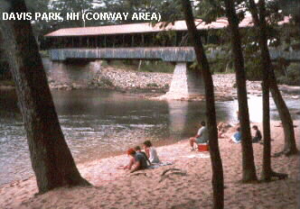
DAVIS PARK [DAVI]:
This small park in Conway has a pretty, narrow beach on the Saco River
just below a covered bridge. In Conway, go north on Washington St. then
east on Eastside Rd. (there is no street sign; on the right there is a
sign that says "NNMHM&Ds",
whatever that is) to the bridge over the Saco River (you reach the
bridge pretty quickly, if not you took the wrong road). Cross bridge
and park on right. The park and beach are here. Very Confident,
verified 7/00. PHOTO
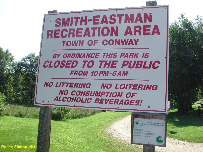
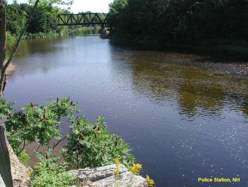
POLICE STATION [POLI]:Just
behind the police station in Conway, at the Smith-Eastman Recreation
Area, there is a deep spot in the Saco River. You can swim here. The
rope swing that was once here has been taken down. Altogether
forgettable. LAT, LON lat=44.00088, lon=-71.08293 Source:
Measured Accuracy: Exact Very Confident. Verified 08/2006. Updated
03/04/2007 PHOTO1
PHOTO2
Link to Google Map
WESTON'S BEACH [WEST]:
Weston's Beach is actually in Maine, just across the line from the
Conway area. To see information on it go to
WESTON'S BEACH
and use BACK to return here.
|
| AREAS |
White Mountain National Forest |
| SANCTION |
Unofficial |
| FEE |
None |
| FACILITIES |
Various |
| ACTIVITIES |
Swimming |
| PHONE |
None |
| CAMPING |
Not at sites |
| BATHING
SUITS |
Unknown |
| DIRECTIONS |
See site information above. |
| CONFIDENCE |
Pretty Confident |
| VERIFIED |
Some, see above |
| DATE
UPDATED |
8/9/2000 |
This swimming hole listing is by
www.swimmingholes.org
CRAWFORD NOTCH AREA
[8 PLACES]
(CRAW)
|
|
| TOWNS |
TWIN MOUNTAIN, BRETTON WOODS, WILLEY
HOUSE, |
| STATE |
NH |
| WATER |
Varies, see below |
| TYPE |
Falls |
| DESCRIPTION |
Several fine swimming places near
Crawford Notch on RT 302. See DIRECTIONS below for details.
|
| AREAS |
White Mountain National Forest, Crawford Notch |
| SANCTION |
Unofficial |
| FEE |
No |
| FACILITIES |
None |
| ACTIVITIES |
Swimming |
| PHONE |
None |
| CAMPING |
None at site. Camp nearby off RT 302 at
Zealand Recreation Area in
National Forest. |
| BATHING
SUITS |
Unknown |
| DIRECTIONS |
From Franconia
Notch, take RT 3 east onto RT 302 at Twin Mountain. Continue east on RT
302, then: (holes are in order from west to east on RT 302)
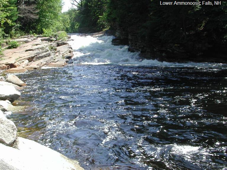
LOWER AMMONOOSUC FALLS
[LOWE]: A small falls in the Ammonoosuc River into a
very large pool makes for a fine family swimming place. (A much gentler
place to swim than at the Upper Ammonoosuc Falls, below.) Sliding place
in falls, rocks to sun and jump. LAT, LON lat=44.26982,
lon=-71.48334 Source: Measured Accuracy: Exact
To get there: Continue on RT 302 about 3.5 miles beyond Twin Mountain
to the street sign on the left for Old Cherry Mtn. Rd. and the sign for
"Lower Ammonoosuc Falls". Turn onto Old Cherry Mtn Road and turn
quickly left again into the parking area. Walk about 5 minutes down the
gravel road to the small falls and huge pool below. PHOTO
Very
Confident. Verified 8/2006. Updated
03/04/2007.
Link to Google Map
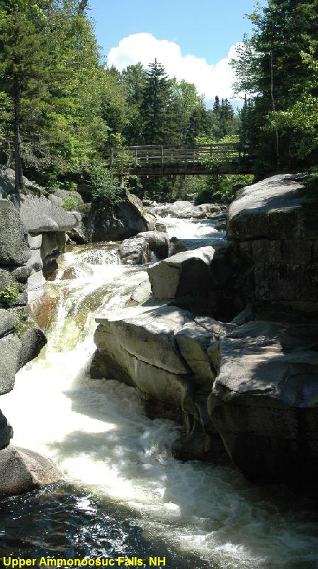
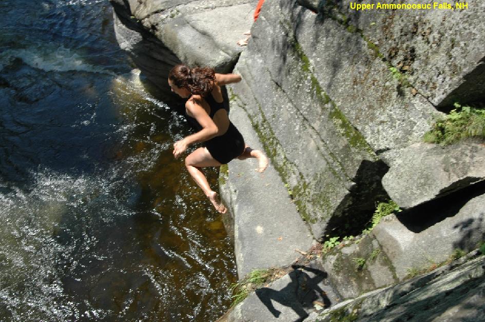
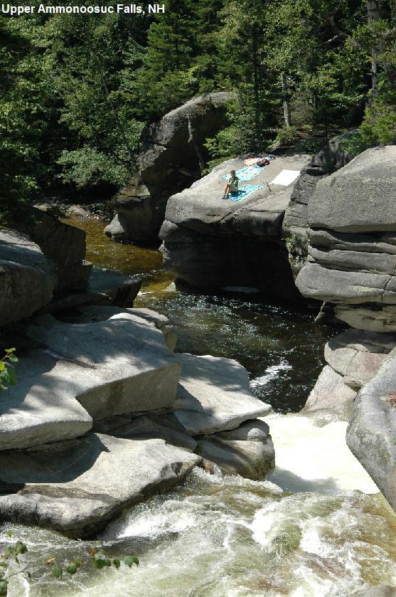
UPPER AMMONOOSUC FALLS
[UPP2]: Deception Brook is a tributary of the Ammonoosuc
River that runs alongside Mt. Washington Cog Railway Base Station Rd
just off RT 302 near Bretton Woods. There are several places to swim
along here, including the popular Upper Ammonoosuc Falls. There are
chutes and pools at the bottom of these falls that are safe to swim in
at lower water levels,
usually in later summer. Do not attempt to swim at the base of the
falls during high water levels when currents can be very strong here.
LAT, LON lat=44.26580, lon=-71.41671 Source: Measured Accuracy:
Exact
Link to Google Map
DON'T SWIM HERE IN HIGH CURRENTS; VERY DANGEROUS!
Following info thanks to Dennis Friedman 8/02: "Is now public property
and 100% legal swimming/diving. One guidebook claims it's the most
dangerous swimming spot in the state. After heavy rain or in early
season, when currents are high, I've seen powerful
whirlpools that would be fatal. But this time of year, it looked pretty
tame."
"Extremely interesting spot with jumping/diving
from many different heights, underwater passages, slideable waterfall,
accessible cave behind/under waterfall and other features but with some
caveats:1) Water flows can be extremely
hazardous / lethal. First timer's should observe others first. I'd
never go there unless there were several others around. 2) Litter can
be a problem sometimes. 3) Property is privately owned and owners have
been lukewarm to swimming, afraid of lawsuits. Sometimes posted,
sometimes not. 4) Jumping is possible (locals do it lots, we've done it
some) but you've got to know where the obstacles are. An error would
probably be fatal. DON'T DO IT!"
To get there: Continue on RT 302 east about 1.4 miles more to the sign
for the Mount Washington Cog Railway on the left. Follow the directions
toward the Railway, turning north here onto Base Station Rd. Go about
2.2 miles to a parking area on the right where there is a mound of dirt
blocking the end of the parking area. Park and walk the path upstream
toward the roar of the falls. There are multiple swimming places. BE
CAREFUL OF THE CURRENTS! PHOTO1
PHOTO2
PHOTO3 Very
Confident. Verified 8/2006. Updated 03/04/2007.
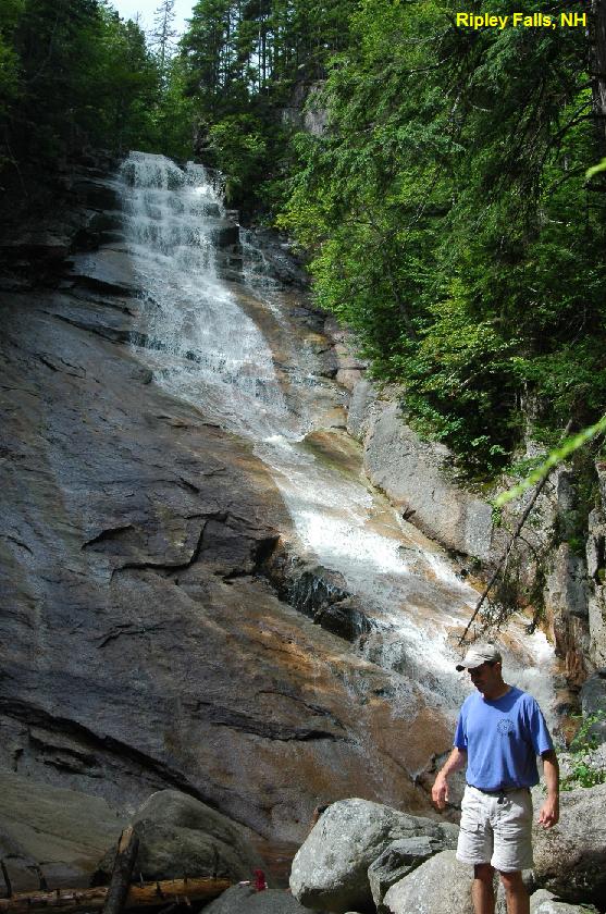
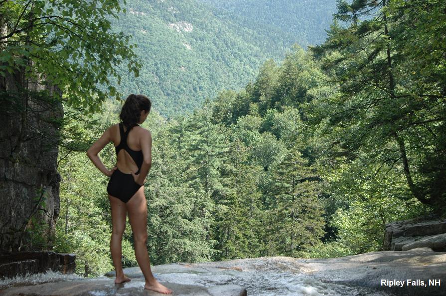
RIPLEY FALLS [RIPL]:
Swimming holes and pools above 100 foot high Ripley Falls. BE SURE THIS
IS SAFE BEFORE SWIMMING! While not as tall as the nearby Arethusa Falls
(see below), they are also a cool place to sit after a summer hike. The
swimming holes are above the falls but DON'T CLIMB UP THE FACE OF THE
FALLS, SLIPPERY ROCKS. Take a trail to the top. Can be disappointing
during times of low water. Spectacular views form the top of the falls.
LAT, LON lat=44.16124, lon=-71.39480 Source: Measured Accuracy:
Exact
Link to Google Map
To get there: Continue east on RT 302 and park where the Appalachian
Trail crosses the road in the parking lot on the west (right) side of
the road. Follow the AT (also known here as Ethan Pond trail) to the
west and the trail signs to Ripley Falls. Camping at Dry River
campground in the White Mtn. N. F. nearby. PHOTO1 PHOTO2
Very Confident. Verified. Updated 03/04/2007.
THE POOL [POOL]:
A 16 mile round trip hike to a great swimming hole with a natural water
slide. LAT, LON lat=44.1338, lon=-71.4706(source: Topozone )
(accuracy: approximate) To get there: Access the AT as in Ripley
Falls directions above but continue on the AT west (also known here as
Ethan Pond trail) about 5 miles to the junction with Shoal Pond Trail.
Turn left on Shoal Pond Trail and go another approximate 3 miles to
"The Pool" swimming hole and campsite. If you get to "Swiftwater
Junction" (where several trails come together) you have gone about 1
mile too far. Uncertain. Not verified. Updated 11/17/2002.
Link to Google Map
ARETHUSA FALLS [ARET]:
Arethusa Falls are the largest waterfalls in the state of New
Hampshire. The water is extremely chilly year 'round and feels great
after a summer hike. LAT, LON lat=44.148, lon=-71.386(source:
Topozone ) (accuracy: exact) To get here: Continue east on RT 302
and, just after the Dry River Campground and the Willey House, park at
the Arethusa Falls parking area on the right. Pull off the road to the
right and drive up the big hill and park near the railroad tracks, if
possible. If the parking lot on the hill is full, there is another one
on your right when you pull off the road to go to Arethusa Falls. Cross
the railroad tracks and go to the left of the wooden house. Be aware
that the house is on private property, even though the trail runs close
to it. Hike up the Arethusa Falls trail. This trail leads also to Bemis
Falls and Coliseum Falls, see below. Very Confident. Not verified.
Updated 11/17/2002.
Link to Topozone Map
Link to Google Map
BEMIS BROOK [BEMI]:
Three swimming places - Fawn Pond, Bemis Falls and Coliseum Falls - are
all on the Bemis Brook Trail, which forks to the left off the Arethusa
Falls Trail pretty close to the parking area. The first you encounter, FAWN POND [FAWN], isn't very deep
(less than 4 feet during the summer of 2002), but there is a good bit
of flat bedrock to sunbathe on. The second, BEMIS FALLS [BEMI], I don't have detailed information for.
The third, COLISEUM FALLS [COLL],
is said to be a very fine swimming hole and is further on the Bemis
Brook Trail. LAT, LON lat=44.14667, lon=-71.37344 (source:
Topozone) (accuracy: general
area)
Link to Google Map
The Bemis Brook trail junctions with the Arethusa Falls trail again
further up the mountain. If one were hiking FROM Arethusa Falls TO the
parking lot, the hike off the main Arethusa Falls trail down to the
other two sites (Fawn and Coliseum) is steep at first. Due to erosion,
the trail is steep with many roots exposed. However, if you are up for
some careful stepping, it is worth hiking down to see Coliseum Falls on
the left. Stepping off the Bemis Brook trail to actually get in the
small pool below the falls is not tricky with just a little rock
scurrying. Very Confident. Not verified. Updated 11/18/2002.
|
This swimming hole listing is by
www.swimmingholes.org
FALLING WATERS
(FALL)
|
|
| TOWNS |
LINCOLN, FRANCONIA |
| LAT,
LON |
lat=44.1367,lon=-71.6725(source:
Topozone) (accuracy: general area)
Link to Google Map |
| STATE |
NH |
| WATER |
Dry Brook |
| TYPE |
Brook |
| DESCRIPTION |
Swimming holes in Dry Brook along
Falling Waters Trail in Franconia Notch State Park. |
| AREAS |
Franconia Notch State Park |
| SANCTION |
Unofficial |
| FEE |
Unknown |
| FACILITIES |
Unknown |
| ACTIVITIES |
Swimming |
| PHONE |
None |
| CAMPING |
None at site |
| BATHING
SUITS |
Unknown |
| DIRECTIONS |
From Lincoln, take
I-93 north. It becomes the Franconia Notch Parkway. After you pass the
"Basin Area", look for the Falling Waters Trail and park. It's best to
ask some of the of other people that are usually there or else to have
a trail map as there are many trails that depart from the parking area
and you need to pass 2 trail junctions before you reach the Falling
Waters trail. Follow the trail along Dry Brook. There is no distinct
swimming area, rather, the trail parallels the brook with
many wading and splashing spots. Small children (3,4,5 or so)
will probably enjoy the brook. This trail is mentioned in many hiking
articles and is suitable for younger families.
|
| CONFIDENCE |
Very Confident |
| VERIFIED |
Yes, by another |
| DATE
UPDATED |
05/27/2004 |
This swimming hole listing is by
www.swimmingholes.org
GORHAM AREA
[3 PLACES]
(GORH)
|
|
| TOWNS |
GORHAM |
| STATE |
NH |
| WATER |
Varies, see below |
| TYPE |
River |
| DESCRIPTION |
Swimming holes near Gorham. See details
under "DIRECTIONS" below.
|
| AREAS |
White Mountain N. F. |
| SANCTION |
Unofficial |
| FEE |
No |
| FACILITIES |
Unknown |
| ACTIVITIES |
Swimming |
| PHONE |
Unknown |
| CAMPING |
Unknown
|
| BATHING
SUITS |
Unknown |
| DIRECTIONS |
These places are all near Gorham as
follows:
PEABODY RIVER [PEAB]:
Swimming place said to be in Peabody River near where RT 2 crosses the
river in Gorham. LAT, LON lat=44.38642, lon=-71.16667(source:
Topozone ) (accuracy: general area) No better directions or description.
Very Uncertain. Not verified. Updated 10/18/2001
Link to Google Map
RANGER STATION POOL [RANG]:Large
pool in the Peabody River for swimming and wading. From Gorham,
take RT 16 south about 4 miles to the Ammonoosuc Ranger Station. Follow
a short path behind the ranger station to the river. LAT, LON
lat=44.32839, lon=-71.21464(source: Topozone ) (accuracy: general
area) Uncertain. Not verified. Updated
11/18/2002.
Link to Google Map
RATTLE RIVER [RATT]:Several
swimming holes said to be in Rattle River along Appalachian
Trail near Gorham. LAT, LON lat=44.39358, lon=-71.10836(source:
Topozone ) (accuracy: general area) . To get there: from Gorham, take
RT 2
east roughly 3 miles to where the AT crosses it. Park here and follow
the AT south along the Rattle River. You should come to the Rattle
River Shelter and, before you have gone a total of 3 miles, you should
find some swimming holes in the river. No better directions. Very
Uncertain. Not verified. Updated
11/18/2002.
Link to Google Map |
| CONFIDENCE |
Uncertain |
| VERIFIED |
no |
| DATE
UPDATED |
11/19/2002 |
This swimming hole listing is by
www.swimmingholes.org
KANCAMAGUS AREA
[9 PLACES]
(KANC)
|
|
| TOWNS |
CONWAY, LINCOLN |
| STATE |
NH |
| WATER |
Various |
| TYPE |
Various |
| DESCRIPTION |
There are many swimming places along the
Kancamagus Highway -
Rt. 112 - a very beautiful road and the highest in New Hampshire. "The
Kanc," as it is known
locally, winds through the White Mountain National Forest for 34 miles
from Conway to
Lincoln, paralleling the Swift River, Hancock Brook and East Branch of
the Pemigewasset River
along the way, with many camping, swimming and picnicking
opportunities.
Here, we list some of the major swimming sites. The order of
presentation is from the Lincoln
(West) end to the Conway (East) end. All distances are approximate:
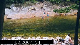
HANCOCK [HANC]:
. Popular swimming place in river behind Hancock
Campground. Very large swimming area. May also be called "Upper Ladies Bath" 0.5 mi from Lincoln,
29 mi from Conway. Park in the parking area after you get through the
camping area. Walk back into the camping area to site #47, look for
sign saying "RIVER". Follow sign a short walk to the river. Camping at
site. PHOTO
FRANCONIA FALLS [FRAN]:
Hike up the popular "Lincoln Woods Trail" into the Pemigewasset
Wilderness to rock chutes and pools in Franconia Brook. -- the
"permit/quota" system there has been abolished. You still need the
parking permit, but there is no longer a limit on hikers/bikers and
no longer a special permit for hiking/biking to Franconia Falls. LAT, LON lat=44.106, lon=-71.577 Source:
Topozone Accuracy: Exact
Link to Google Map
The following is thanks to Dennis Friedman on 8/02: " There is now
camping available again, in a slightly different area. There is now
also a new bicycle trail that goes about 80% of the way to it. (but you
must cross a river on hopping stones w/o the
bicycles for final access). This area is a prime example of how White
Mountain water flows can change things markedly. At moderate flows, it's a
fun place for kids. At low levels, you can bump your derriere on the
way down since there's not enough water to cushion it. At high levels,
it can get dangerous as a current forms in the pool underneath it that
pushes you down. No great problem for a decent swimmer but potentially
troublesome for kids. I've seen hiking groups go out there equipped
with ropes & throw buoys & rescue hooks - preparing for
possible troubles by their members. Also water temp can change markedly
from day/day, which also affects safety."
To get there: 5 mi from Lincoln, 29 mi from Conway. Continue east on
Rt. 112 to the Pemigewasset ("Pemi") Ranger Station, (Lincoln Woods
Information Center) by Loon Mt. Park and obtain information and permit
here. (You can also hike to this ranger station from Hancock Campground
if you wish.) You will cross the east branch of the Pemi on a foot
bridge and hike up three miles on an old railroad bed along the east
branch. This brings you to Franconia Brook campsites (campsite may be
closed, ask at ranger station). About .3 mi up along Franconia Brook,
there are chutes you can ride down in the river, and 100 yards further
up is a nice pool 30 ft across. The trail ends here, but the river
keeps going. Very Confident. Not verified. Updated 11/3/2001.
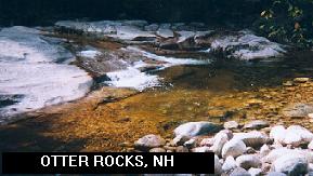
OTTER ROCKS [OTTE]:
Quiet, very small, very shallow � swimming place in river near Otter Rocks roadside rest/picnic
area. 8 mi from Lincoln, 26 mi from Conway. Park at Otter Rocks
rest/picnic area and walk down to the river. Swimming place is here. No
camping here. PHOTO Very
Confident. Verified. Updated 08/2006
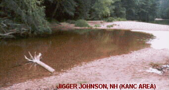
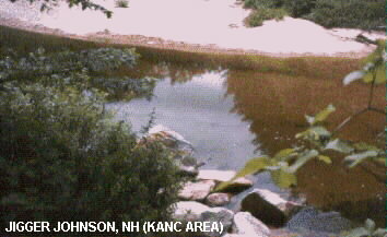
JIGGER JOHNSON [JIGG]:
Swimming places in river at Jigger Johnson campground (signed). 22
mi from Lincoln, 12 mi from Conway. Park in the Jigger Johnson
Campground and walk to river. There are two swimming locations here,
both with signs that say "Swift River": One is across from campsite
#60, the other across from campsite #49. The first is deep but has
little beach, the second one is shallower but has a better beach; a
better place for kids. Camping at the site. LAT, LON
lat=43.994, lon=-71.331 Source: Topozone Accuracy: Exact
PHOTO1 PHOTO2
Link to Google Map
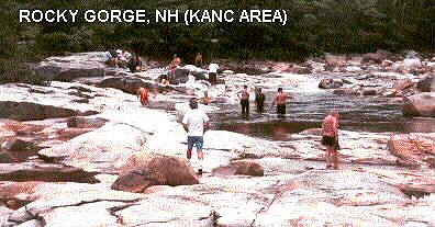
ROCKY GORGE SCENIC AREA
[ROCK]: River has carved out slots in rocks. 24 miles from
Lincoln, 10 mi from Conway. Signs say that swimming is permitted
upstream of the gorge, you can swim legally anywhere except in the area
below the bridge. No camping at site. Blackberry Crossing Campground
and Covered Bridge Campground are both nearby. Very Confident. Verified
08/2006 Updated 03/04/2007 PHOTO
EAST ROCKY GORGE [EAST]:
After you pass the west entrance to Rocky Gorge going east on the Kanc,
you will see the sign for the east entrance, says "Rocky Gorge Entrance
.25 mile". Just past this sign on the Kanc, there is a gravel pull out
area on the left (north) side of the road. This is a local swimming
place where there is (apparently) no White Mountain National Forest parking permit
required as there is at most of the other Kanc places.
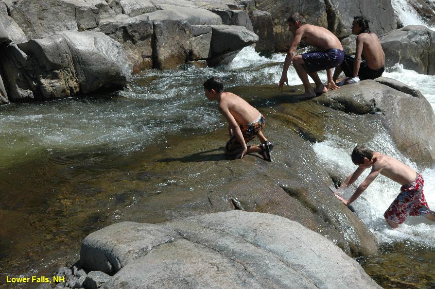
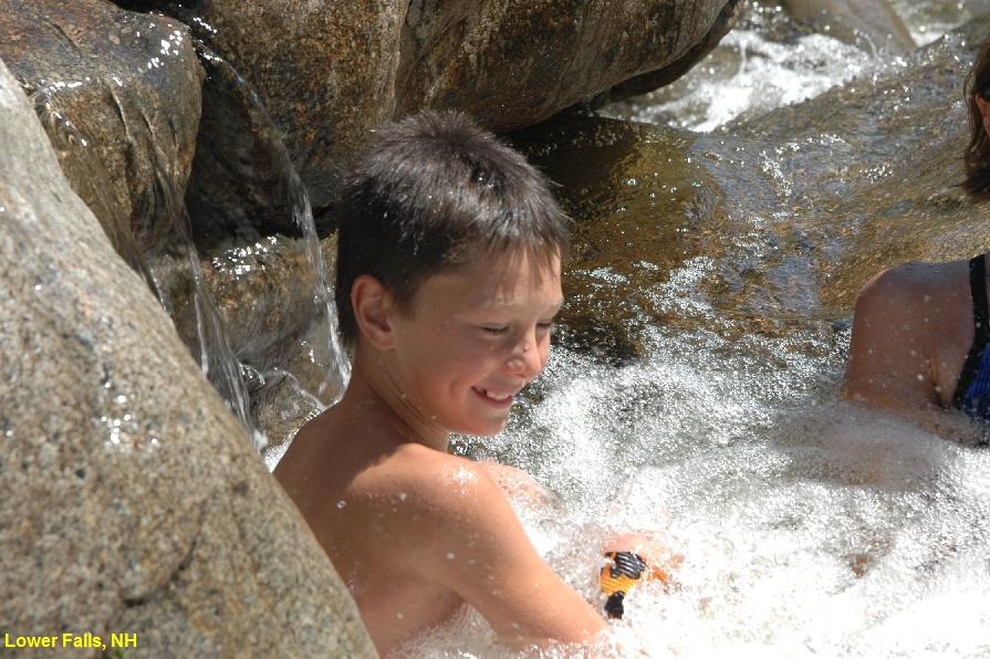
LOWER FALLS [LOW1]:
Extremely popular family water fun and
swimming place in pool at bottom of falls. 26 mi from Lincoln, 8 mi
from Conway. Very large parking area on north side of road, well
signed, sometimes crowded. Picnic area and rest rooms. Slide, jump and
play in numerous small rapids and pools. There is one VERY large pool
for swimming. Swimming is permitted here. No camping at site.
Blackberry Crossing Campground and Covered Bridge Campground nearby.
LAT, LON lat=44.01519, lon=-71.24481 Source: Measured Accuracy:
exact) PHOTO 1
PHOTO 2
Link to Google Map
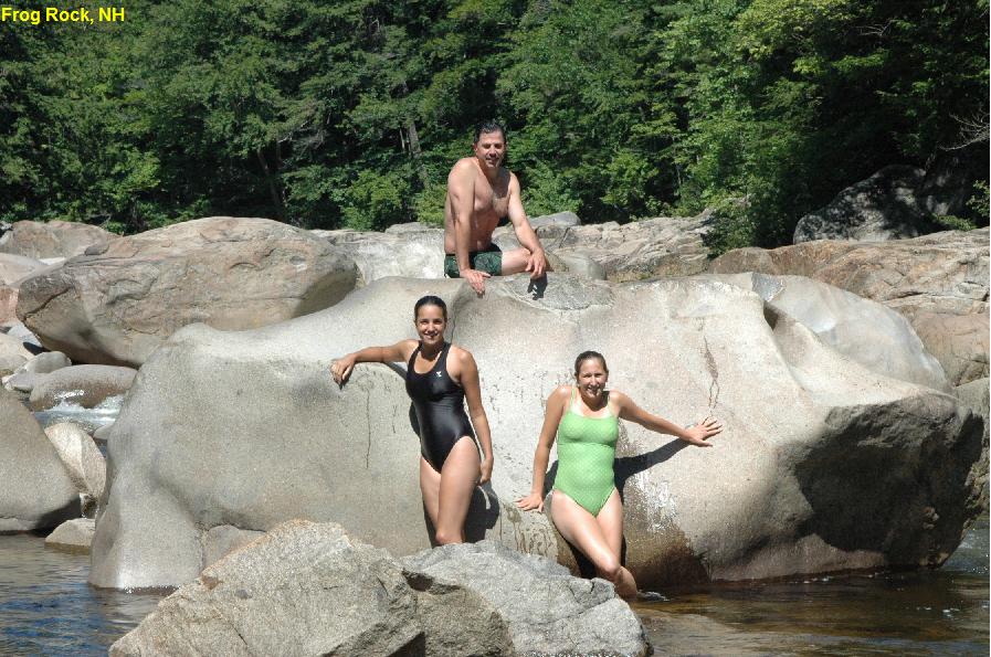
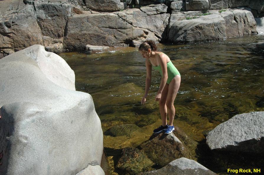
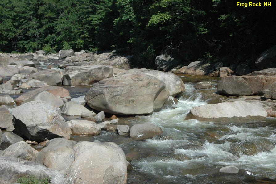
FROG ROCK [FROG]:
(May also be known as "Big Eddy".) Small swimming hole up against a
large rock on the Swift River. LAT, LON lat=43.99320,
lon=-71.20884 Source: Measured Accuracy: Exact . This is roughly 2 miles east of Lower
Falls and about .5 miles west of the Loon Mountain billboard. There is
a wooden retaining wall on the left (south) side of the road and a
guardrail on the north side. Cars may be parked along the side of the
road, no signs. Park and climb over the guardrail to a large rock over
the Swift River. The swimming holes is here. Very Confident. Verified.
Updated 03/04/2007. PHOTO1
PHOTO2
PHOTO3
Link to Google Map
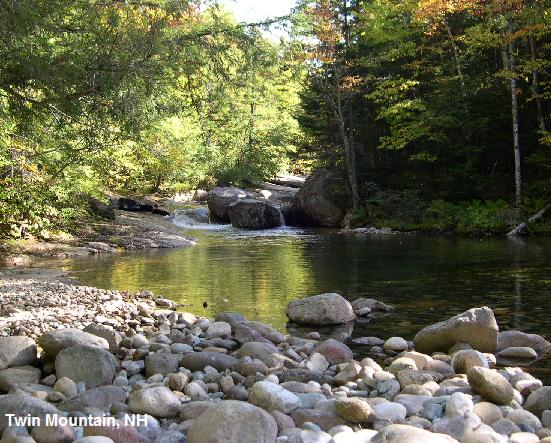
TWIN
MOUNTAIN [TWIN]: A small, private swimming hole nestled
deep in the White Mountains. LAT, LON lat=44.240160 lon=-71.548500 Source: Map Point) Accuracy: Exact Directions; Follow RT 93 north to RT 3 north
(exit 35). Follow RT 3 North about 8 miles, on your right there is a
dirt road with a marker that has FR 304 (if you pass Last Chance
Cabins, you just missed it). Follow this road to the end (approx 2
miles) park in the lot and walk down to the bridge you just drove over.
On the right side of the bridge looking down the river is a foot trail,
follow this down river 0.5 miles. The swimming hole is here, with lots
of flat rocks for lounging. Not Verified. Uncertain. Bathing Suits :
Unknown PHOTO
Link
to Google Map
|
| AREAS |
White Mountain National Forest, Kancamagus Scenic
Byway
|
| SANCTION |
Varies, see above |
| FEE |
$5.00 for all-week, all-site parking
pass. |
| FACILITIES |
Various, see above |
| ACTIVITIES |
Swimming, jumping, sliding |
| PHONE |
Unknown |
| CAMPING |
See site information above. |
| BATHING
SUITS |
Customary |
| DIRECTIONS |
See site information above. |
| CONFIDENCE |
Very Confident |
| VERIFIED |
See above |
| DATE
UPDATED |
03/03/2007 |
This swimming hole listing is by
www.swimmingholes.org
LINCOLN AREA
[3 PLACES]
(LINC)
|
|
| TOWNS |
LINCOLN, WOODSTOCK, NORTH WOODSTOCK |
| STATE |
NH |
| WATER |
Varies (see below) |
| TYPE |
Varies (see below) |
| DESCRIPTION |
Swimming places near the busy tourist
town of Lincoln. See DIRECTIONS below for details.
|
| AREAS |
White Mountain National Forest |
| SANCTION |
Unofficial |
| FEE |
No |
| FACILITIES |
Unknown |
| ACTIVITIES |
Swimming |
| PHONE |
Unknown |
| CAMPING |
Hancock campground in White Mtn. National Forest is
nearby. |
| BATHING
SUITS |
Some optional, see below |
| DIRECTIONS |
Lincoln is at the
western end of the Kancamagus Highway on I-93. To get to the swimming
places:
CRYSTAL CASCADE [CRYS]:
This is a town park in North Woodstock. Pemi Brook tumbles a fair
distance over a slide-able or tube-able chute, over several small rapids,
into a small pool. Another family/kids favorite. Very convenient to
several restaurants, ice cream, & fudge place. (2 minutes walk
to any of the above) Fairly warm water in afternoon. Suggest cutoffs or
similar. Thin suits can get torn or frayed on sliding. To get there: On
RT 3 just north of Kancamagus Highway intersection. Park at row of
stores across from gas station. Find small arch over a footpath between
laundry & other stores. Pretty Confident. Not verified. Updated
6/13/2002.
GEORGIANA FALLS [GEOR]:
Beautiful falls on Harvard Brook in a wooded setting
with pool just big enough to swim in - cold water. Bathing suits may be
optional here. To get there: Georgiana Falls on Harvard Brook are
accessed by an unmarked trail leaving from a parking area off Hanson
Farm Rd. in Lincoln (I think this is off of RT 3 north of Lincoln.
Harvard Brook joins RT 3 north of Lincoln, just south of Franconia
Notch.). An easy 1.3 mile hike leads to lower falls in a beautiful
wooded setting. The Upper, or Harvard Falls, are a steep 0.5 mile
farther. Pretty Confident. Not verified. Updated 11/03/2001.
BASTINS POOL [BAST]:
A swimming place on RT 175 (The Thornton Gore Road). I think this is
south of Lincoln, off RT 175 south of Woodstock. Very Uncertain. Not
verified. Updated 11/03/2001.
|
| CONFIDENCE |
Varies |
| VERIFIED |
No |
| DATE
UPDATED |
07/2019 |
This swimming hole listing is by
www.swimmingholes.org
MERRIMACK RIVER
(MERR)
|
|
| TOWNS |
CONCORD |
| LAT,
LON |
lat=43.25697,lon=-71.55885 Source:
MapPoint Accuracy: Exact
Link to Google Map |
| STATE |
NH |
| WATER |
Merrimack River |
| TYPE |
River |
| DESCRIPTION |
Swimming in an
eddy of the Merrimack River.
Nice sandy beach, interesting old power station nearby, walking trails
for fishing and mountain biking all along the river. The swimming hole
is an eddy in the river, but you can go out into the deeper river if
you'd like. There are some very small rapids just south of the swimming
hole (visible from the beach) which are created by the remnants of an
old rail road trestle. During the times of high water in the spring,
firefighters may use this area for water rescue training. During late
summer, kids tube over the rapids with no problems. Great little spot
only the locals seem to know about. Does get crowded in the late
afternoon, dinner time during the week it's pretty empty. Weekends are
packed, get there early for a spot on the beach or a parking spot.
|
| AREAS |
None |
| SANCTION |
Unofficial |
| FEE |
Unknown |
| FACILITIES |
None |
| ACTIVITIES |
Swimming |
| PHONE |
None |
| CAMPING |
None at site |
| BATHING
SUITS |
Unknown |
| DIRECTIONS |
Take
exit 15 off of I93 and get onto route 3 north.
About a 1.5 miles past the State Prison there is a slight fork in the
road (route 3 goes to the left) and there is a sign for Beaver Meadow
Golf Course. Bear right onto Sewall's Falls Road toward Beaver Meadow.
Beaver Meadow School will be on your right. Just past the school, take
a right onto Second Street and go down the hill. It is a residential
area. At the bottom of the hill cross the RR tracks and you'll be on
property belonging to NHDES. Go left into the parking area. The parking
area on the right is for walking and mountain biking trails along the
Merrimack. At the end of the parking lot is a dirt trail which goes up
over a slight incline and down to the banks of the Merrimack River.
|
| CONFIDENCE |
Pretty Confident |
| VERIFIED |
No |
| DATE
UPDATED |
02/20/2006 |
This swimming hole listing is by
www.swimmingholes.org
NORTH CONWAY AREA
[3
PLACES]
(NORT)
|
|
| TOWNS |
NORTH CONWAY |
| STATE |
NH |
| WATER |
Various |
| TYPE |
Various |
| DESCRIPTION |
There are several
swimming places very close to North Conway. Here we list some of the
major ones. To get to all, begin from North Conway and take River Rd.
west out of town, (passes between 2 gas stations). Then:
FIRST BRIDGE [FIRS]:
This is a popular local swimming hole by a bridge in North Conway on
the Saco River-has a grass beach. No jumping from the bridge! To get
there: As you leave North Conway, River Rd. crosses 2 bridges, one of
these (the biggest) is "First Bridge" (or "First Iron Bridge") which is
well signed. The are parking areas and swimming places at both ends of
this bridge, as well as a canoe ramp. Very Confident, not verified.
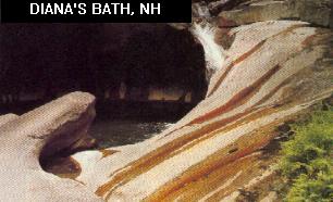
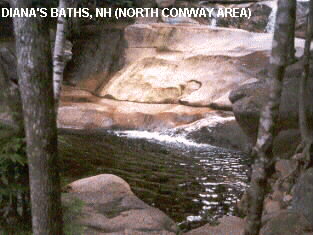
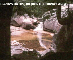
DIANA'S BATHS [DIAN]:
Cedar Brook flows over smooth rocks into pools. You can slide on the
smooth rocks and swim in the pools, if the water is deep enough when
you are there. Typical of the "Public" areas in this part of New
Hampshire, this swimming hole cna be crawling with people during the
hot summer months. To get there, continue west on River Rd. then turn
north (right) on West Side Rd.. Go 1.4 miles to well signed parking
area for Diana's Baths. (White Mountain National Forest permit required to park.)
Walk .6 miles to pools. LAT, LON lat=44.07175,
lon=-71.17070 Source: Measured ) Accuracy: Exact . Very Confident. Verified 08/2006 PHOTO 1 PHOTO 2 PHOTO 3
Link to Google Map
HUMPHREYS LEDGE [HUMP]:Deep
water swimming in the Saco River. If you want to get away from the
crowds for a nice quiet swim, this is the place to go. There is nothing
exceptional about this place, however, it does possess an indescribable
allure. Suggest getting here earlier in the day so that the sun shines
on the large rock where you are most likely going to hang out during
your. To get there: Continue north on West Side Rd.. Go roughly 0.6
miles past the Diana's Baths parking area to the Humphrey's Ledge
Recreation Area. You will see a dirt parking area on the left side of
the road. Park here, cross the road and scramble down to the river.
LAT, LON lat=44.09639, lon=-71.16915 Source: Measured )
Accuracy: Exact . Very Confident. Verified
08/2006
Link to Google Map
|
| AREAS |
White Mountain National Forest |
| SANCTION |
Unofficial |
| FEE |
Parking pass required at White Mtn. National Forest
parking
places |
| FACILITIES |
Varies |
| ACTIVITIES |
Swimming, Sliding, Jumping |
| PHONE |
Unknown |
| CAMPING |
Unknown |
| BATHING
SUITS |
Unknown |
| DIRECTIONS |
See site information above. |
| CONFIDENCE |
Pretty Confident |
| VERIFIED |
Some, 7/00 |
| DATE
UPDATED |
10/19/2001 |
This swimming hole listing is by
www.swimmingholes.org
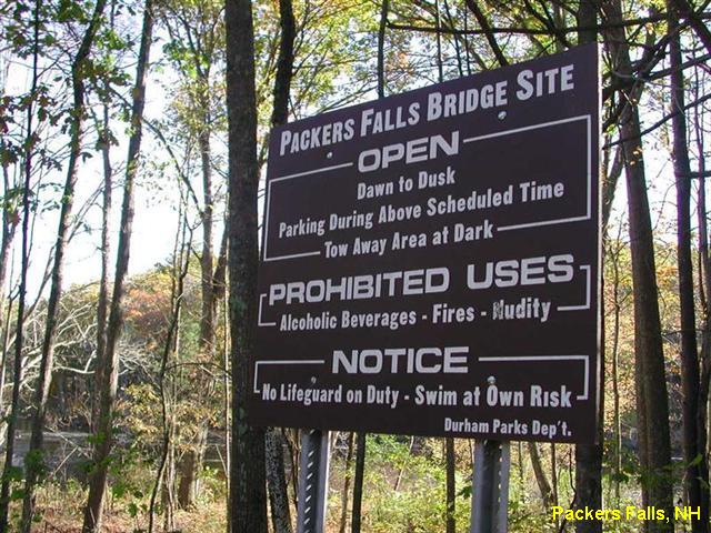
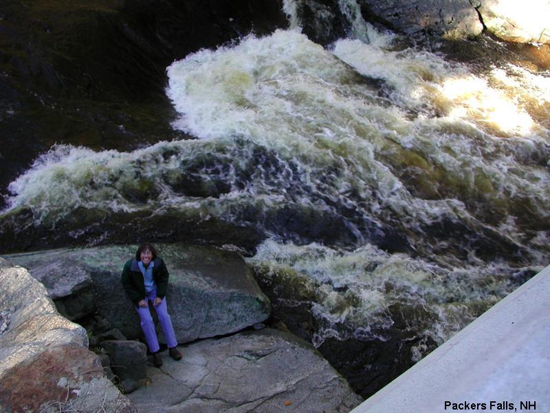
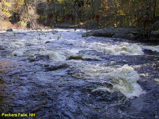
PACKERS FALLS
(PACK)
|
|
| TOWNS |
DURHAM, PORTSMOUTH |
| LAT,
LON |
Lat=43.10496,
Lon=-70.95139 Source: Measured Accuracy: Exact
Link
to Google Map |
| STATE |
NH |
| WATER |
Lamprey River |
| TYPE |
Falls |
| DESCRIPTION |
Popular swimming area in the Lamprey
River just outside of Durham.
|
| AREAS |
None |
| SANCTION |
Unofficial |
| FEE |
No |
| FACILITIES |
None |
| ACTIVITIES |
Swimming |
| PHONE |
None |
| CAMPING |
None at site. |
| BATHING
SUITS |
Required |
| DIRECTIONS |
From the center of
Durham, follow RT 108 south for 1.5 miles and then take a right onto
Bennet Road. Stay right at all "Y" intersections and follow Bennet Road
all the way to the end where it intersects Packers Falls Rd. Just before
reaching Packers Falls Rd, there is a small parking lot on the left. Take a
left on Packers Falls Rd and immediately cross over the bridge. There
will be a second small parking area on the left.
|
| CONFIDENCE |
Very Confident |
| VERIFIED |
Yes |
| DATE
UPDATED |
02/20/2006 |
This swimming hole listing is by
www.swimmingholes.org
PINKHAM NOTCH AREA
[3 PLACES]
(PINK)
|
|
| TOWNS |
JACKSON, GLEN, PINKHAM NOTCH |
| STATE |
NH |
| WATER |
Varies (see below) |
| TYPE |
Varies (see below) |
| DESCRIPTION |
Swimming places (or splashing places,
maybe too shallow for swimming, but popular) along RT 16 in the Pinkham
Notch area, south of Gorham and north of North Conway. See DIRECTIONS
below for details. |
| AREAS |
White Mountain N. F. |
| SANCTION |
Unofficial |
| FEE |
No |
| FACILITIES |
Unknown |
| ACTIVITIES |
Swimming |
| PHONE |
Unknown |
| CAMPING |
None at sites. |
| BATHING
SUITS |
Unknown |
| DIRECTIONS |
From North Conway, take RT 16 north,
then:
JACKSON FALLS [JACK]:
Very popular swimming, picnicking place at falls in Jackson Village on
the Wildcat River. To get there: From North Conway, take RT 16 north
through Glen (careful to stay on RT 16 in Glen) to Jackson Village.
Turn right off of RT 16 in Jackson onto RT 16A (or 16B?). The falls are
right by the side of the road, off RT 16A, beside Carter Notch Rd. in
the center of town.
GLEN ELLIS FALLS [GLEN]:
Very popular and crowded falls. You cannot swim at the falls, but hike
a steep trail downstream, with steps and guardrails, and continue along
the brook. There are several small waterfalls and swimming areas here.
Bathing suits may be optional as you get further downstream. To get
there; Continue north on RT 16 to .7 miles before (south of) Pinkham
Notch. Use parking area for the Glen Boulder and Wildcat Ridge trails.
Use pedestrian tunnel to get to other side of highway and walk .2 miles
to the falls.
THOMPSON FALLS [THOM]:
Falls on Thompson Brook with small pool at the bottom of the falls.
During dry times, just enough room to get wet. During flood times, DO
NOT SWIM, STRONG CURRENTS! Continue on RT 16 north through Glen
(careful to stay on RT 16 in Glen) past Jackson Village. Continue on RT
16 north (toward Gorham) to the Wildcat Mountain Ski Area. Park in the
ski area parking lot near the ticket booth. Crossing the bridge and
turn left and follow the signs to Thompson Falls, maybe a 30 minute
walk. |
| CONFIDENCE |
Pretty Confident |
| VERIFIED |
No |
| DATE
UPDATED |
11/03/2001 |
This swimming hole listing is by
www.swimmingholes.org
PISGAH STATE PARK
(PISG)
|
|
| TOWNS |
KEENE, WINCHESTER, HINSDALE |
| LAT,
LON |
lat=42.811,lon=-72.449(source: Topozone)
(accuracy: general area)
Link to Google Map |
| STATE |
NH |
| WATER |
Kilburn Pond |
| TYPE |
Swimming place in a pond. |
| DESCRIPTION |
Swimming area in Kilburn Pond in Pisgah
State Park. There is another body of water in the park, Pisgah
Reservoir. This is not the swimming area described here. Kilburn Pond
is separate form the reservoir. |
| AREAS |
Pisgah State Park |
| SANCTION |
Unofficial |
| FEE |
None |
| FACILITIES |
Unknown |
| ACTIVITIES |
Swimming |
| PHONE |
603-239-8153 (State Park) |
| CAMPING |
None in State Park |
| BATHING
SUITS |
Optional |
| DIRECTIONS |
From Keene, take
route 9 West towards Brattleboro VT, go south on RT 63 towards Hinsdale
NH. In about 3 miles, turnleft into the parking lot for the
Kilburn Rd trailhead at Pisgah State Park. Walk down trail
approximately 0.7 miles and stay to the right when it forks. Cross a
makeshift log footbridge and look to your left for small
unmarked paths to Kilburn Pond (you should be able to see the pond).
There is a spot with large rocks good for sitting and jumping from.
Very secluded.
|
| CONFIDENCE |
Pretty Confident |
| VERIFIED |
No |
| DATE
UPDATED |
01/23/2005 |
This swimming hole listing is by
www.swimmingholes.org
SAWYER AREA
(SAWY)
[3 PLACES]
|
|
| TOWNS |
BARTLETT |
| STATE |
NH |
| WATER |
Sawyer Brook |
| TYPE |
Creek |
| DESCRIPTION |
Swimming places in Sawyer Brook west of
Bartlett on RT 302. See "DIRECTIONS" below for details.
|
| AREAS |
White Mountain N. F. |
| SANCTION |
Unofficial |
| FEE |
No |
| FACILITIES |
Unknown |
| ACTIVITIES |
Swimming |
| PHONE |
Unknown |
| CAMPING |
Unknown
|
| BATHING
SUITS |
Required |
| DIRECTIONS |
From Bartlett go
west on RT 302 as follows:
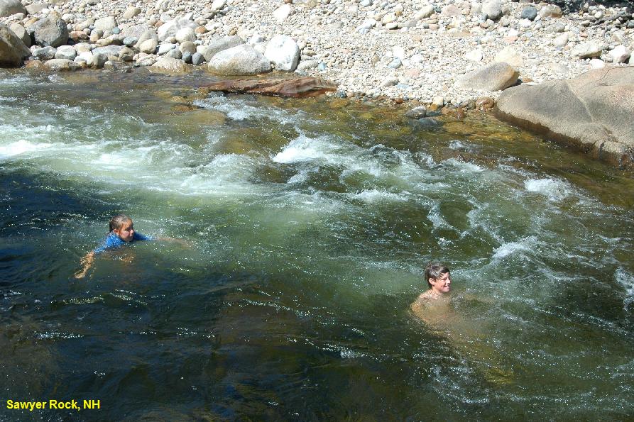
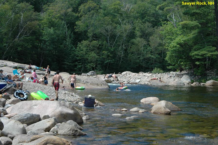
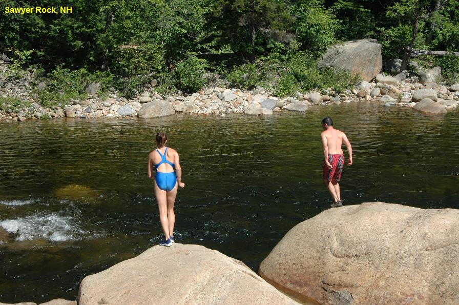
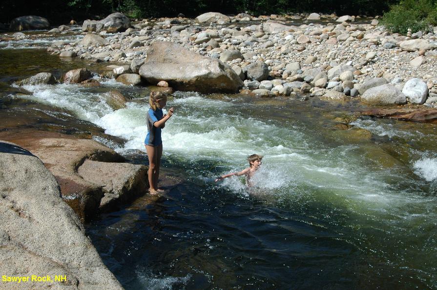
SAWYER ROCK [SAWR]:
A super, fun swimming area that has a little bit of everything. Deep
pools, swift current, shallow wading areas, rocks for jumping and an
enormous rock for sunning. Can be busy, but the medium sized parking
area on the road keeps this place from being overwhelmed. You certainly
don't want to miss this fun place. Go 0.5 miles west on RT 302 past the
Silver Springs Campground. Look for the well worn parking area on the
right side of the road. Park just before you cross over a small brook
that runs through a culvert beneath the road. Lat=44.07659,
Lon=-71.33570 Source: Measured Accuracy: Exact Very Confident. Verified 08/2006 PHOTO1
PHOTO2
PHOTO3
PHOTO4
Link to Google Map
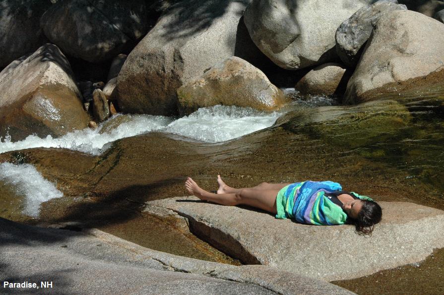
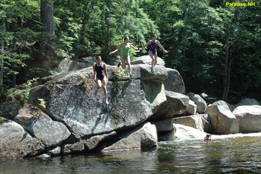
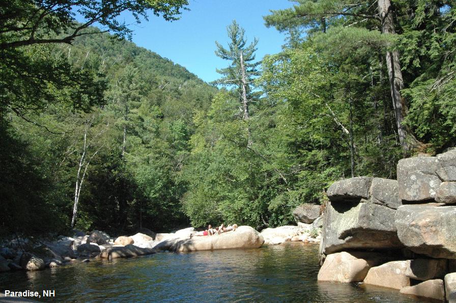
PARADISE [PARA]:
A pristine swimming hole that is not trampled by the crowds. Excellent
rocks for jumping. Smooth rocks for sunning. Peaceful, beautiful and
serene. You'll just have to experience this one to understand why it's
called Paradise. Go 2.6 mi west past Bear Notch Road. There is a
trailhead on the left for Sawyer Pond Trail. There is a road that goes
up to the Sawyer Pond Trail, but it may be closed. If it is open, drive
up the road for about 1.0 miles to a small parking area on the left at
a turn in the road. Park here and walk steeply downhill to Paradise. Confident.
Verified 8/2007 Lat=44.07744, Lon=-71.37037 Source:
Measured Accuracy: Exact Very Confident. Verified 08/2006 PHOTO1
PHOTO2
PHOTO3
Link to Google Map
BREEDER POOL [BREE]:
From Bartlett take RT 302 west 2.8 miles past Bear Notch Rd. (just past
"SAWYER BROOK" swimming hole) There is a small bridge that says "E2".
Park on the right (north side) just before you cross this bridge.
(There are often cars parked here.) Park and walk a short distance
north to the Saco River. (Very Confident, Verified 03/2007)
|
| CONFIDENCE |
See above |
| VERIFIED |
See above |
| DATE
UPDATED |
10/19/2001 |
This swimming hole listing is by
www.swimmingholes.org
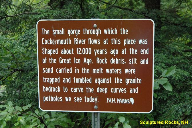
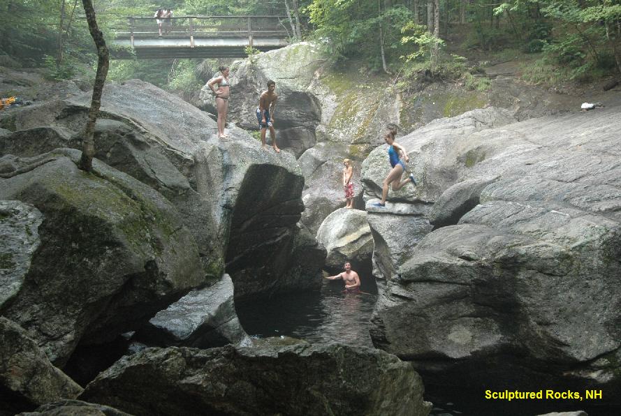
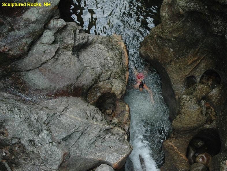
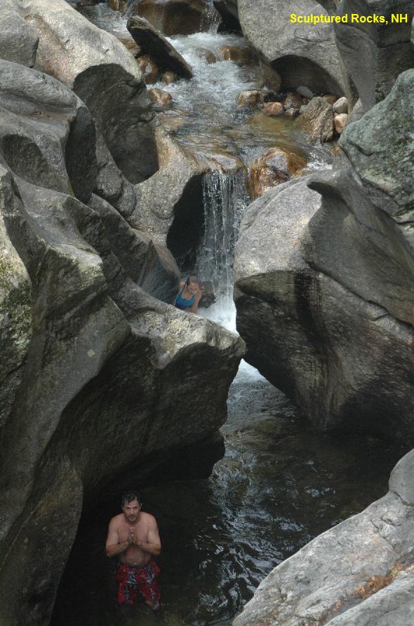
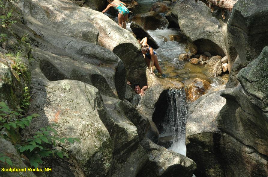
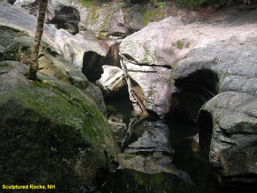
SCULPTURED ROCKS
(SCUL)
|
|
| TOWNS |
HEBRON, GROTON |
| LAT,
LON |
lat=43.70732, lon=-71.85523 Source: Measured Accuracy: Exact
Link to Google Map |
| STATE |
NH |
| WATER |
Cockermouth River |
| TYPE |
Falls |
| DESCRIPTION |
Spectacular and
extremely scenic. Clean, cold pools, a twisting cavern, narrow
passages, secret passage ways, lots of jumping from various heights.
Lots to to and explore. One of the most beautiful scenic and geologic
sites in New Hampshire. Even if you aren't going to swim, this is a
spot you shouldn't miss. A bit eerie when there are no people around.
(See photo 6 above)
|
| AREAS |
Sculptured Rocks State Natural Area |
| SANCTION |
Semi-official |
| FEE |
None |
| FACILITIES |
None |
| ACTIVITIES |
Swimming, Jumping, Fishing |
| PHONE |
None |
| CAMPING |
None at site. |
| BATHING
SUITS |
Customary |
| DIRECTIONS |
From Concord, go
north on I-93 to exit 23 then west on RT 104 to Bristol then north on
RT 3A to RT 3 along the west side of Newfound Lake to Hebron. Go west
through the town of Hebron to Groton. From Groton, you follow
Sculptured Rocks Rd. until you see the parking area on the left. (about
4 miles). (Signs point directions from the center of town in Groton.
It's also shown on the roadmaps they give out at the state visitors'
centers.)
|
| CONFIDENCE |
Very Confident |
| VERIFIED |
Yes |
| DATE
UPDATED |
03/04/2007 |
This swimming hole listing is by
www.swimmingholes.org
SWIFTWATER BRIDGE
(SWIF)
|
|
| TOWNS |
SWIFTWATER,
BATH, WOODSVILLE |
| LAT,
LON |
lat=44.13388,lon=-71.95095
Source: MapPoint Accuracy: Exact
Link to Google Map |
| STATE |
NH |
| WATER |
Wild
Ammonoosuc River |
| TYPE |
River |
| DESCRIPTION |
Swimming under
the historic Swiftwater covered bridge. There are rocks to cross
upstream of the bridge, rocks to lay on, a pool to swim in at
the bottom. Depth varies on rainfall. The locals
call it the "Eddie"
|
| AREAS |
White
Mountain National Forest |
| SANCTION |
Unofficial |
| FEE |
None |
| FACILITIES |
None |
| ACTIVITIES |
Swimming |
| PHONE |
None |
| CAMPING |
None
at site |
| BATHING
SUITS |
Customary |
| DIRECTIONS |
From I-91 take
exit 17 onto RT 302. Follow RT 302 east. Cross the Connecticut River
and continue into the small village of Woodsville where RT 302 is
joined by RT 10. Continue along RT 302/10 for approximately 2.5 miles
to the intersection with RT 112. Take a right onto RT 112 and follow it
for approximately 2 miles. You will see the covered bridge on
your left.
|
| CONFIDENCE |
Pretty
Confident |
| VERIFIED |
Not
Verified |
| DATE
UPDATED |
02/20/2006 |
This swimming hole listing is by
www.swimmingholes.org
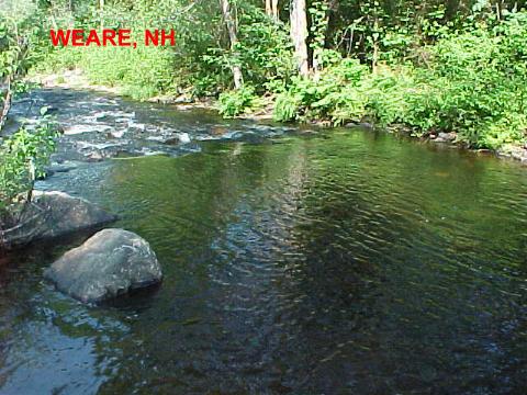
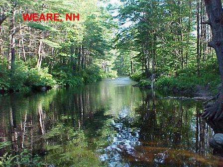
WEARE
(WEAR)
|
|
| TOWNS |
CONCORD, DUNBARTON, WEARE |
| STATE |
NH |
| WATER |
Piscataquog River |
| TYPE |
River |
| DESCRIPTION |
Several swimmable pools in the river
along the road. The river fluctuates with the amount of rainfall in the
season but there are always pools available up to 4 feet deep to swim
in. The site is mostly used by adults, as it is rocky and caution
should be used with small children. There is a rope swing at the widest
part, 30 feet, in the river. |
| AREAS |
Army Corps of Engineers flood control
area, Clough S. P. |
| SANCTION |
Unofficial |
| FEE |
No |
| FACILITIES |
All facilities nearby at Clough State
Park |
| ACTIVITIES |
Swimming |
| PHONE |
Unknown |
| CAMPING |
None at site. |
| BATHING
SUITS |
Optional |
| DIRECTIONS |
From Concord, take I-89 west to exit 2.
Head towards Bow and Dunbarton on Clinton Street (which becomes RT 77).
Once you get to Dunbarton, you will go up a long hill just after
getting into town. At the top of the hill will be a 3 way stop
intersection. Continue straight on RT 77. You will now take the first
left (couple miles down) onto Ray Rd. which is across from the town
transfer station. Follow Ray Road to the end. It will turn to dirt half
way. At the end, Stark pond is on the left (don't swim there), turn
right into the
Hopkinton-Everett Recreation Area. Follow that down to the locked gate
back entrance to Clough State Park (nice day use park) and turn right,
still on dirt road. Now all along the left, for the rest of the road,
there are pull off areas with swimming holes. Best is about a mile down
to the actual river, where it narrows and the water speed increases.
There you will find many wonderful places to swim. The river runs along
the road but is well sheltered from view of the road by vegetation. At
night it is a skinny dipping heaven. |
| CONFIDENCE |
Very Confident |
| VERIFIED |
No |
| DATE
UPDATED |
11/3/2001 |
HOME
|