
MICHIGAN SWIMMING HOLES |
|---|
Click here to see the home page and learn about swimming holes in other states
This swimming hole listing is by www.swimmingholes.org
|
| |
|---|---|---|
| TOWNS | MARQUETTE, GWINN | |
| LAT, LON | lat=46.283378, lon=-87.438099(source: Map) (accuracy: approximate) LINK TO GOOGLE MAP | |
| STATE | MI | |
| WATER | East Branch Escanaba River | |
| TYPE | River | |
| DESCRIPTION | Nice swimming place in river at county campground near upper peninsula. Don't know if you have to register at campground to use swimming hole. CAMPGROUND REVIEW. | |
| AREAS | None | |
| SANCTION | Unofficial | |
| FEE | Unknown | |
| FACILITIES | All facilities at campground | |
| ACTIVITIES | Swimming | |
| PHONE | 906.346.9217 | |
| CAMPING | At site, all hookups for RVs. | |
| BATHING SUITS | Customary | |
| DIRECTIONS | From Marquette (on the south shore of Lake Superior near the UP) go south on RT 553 the west on Rt 35 (North Pine St) into Gwinn. In Gwinn, go north on Spruce St., west on Iron St. then north again on W. Carbon St. into the park. The river swimming hole is in the park. Don't know if you have to register at campground to use swimming hole. | |
| CONFIDENCE | Pretty certain | |
| VERIFIED | No | |
| DATE UPDATED | 1/2013 |
This swimming hole listing is by www.swimmingholes.org
|
| |
|---|---|---|
| TOWNS | MACKINAW CITY, CEDARVILLE | |
| LAT, LON | lat=46.08750, lon=-84.63356(source: DeLorme) (accuracy: approximate) LINK TO GOOGLE MAP | |
| STATE | MI | |
| WATER | Quarry | |
| TYPE | Quarry | |
| DESCRIPTION | This from a visitor:"There is an old rock quarry that has filled with water. I used to go there all the time when I was a kid and it is a great place to swim and jump/dive. " We are not sure that this place still exists or is legal or safe for swimming - use extreme caution . If you have current information about it, please tell us. | |
| AREAS | None | |
| SANCTION | Unofficial | |
| FEE | None | |
| FACILITIES | Unknown | |
| ACTIVITIES | Swimming | |
| PHONE | Unknown | |
| CAMPING | Unknown | |
| BATHING SUITS | Unknown | |
| DIRECTIONS | From Mackinaw City, go north on I-75 across the Mackinac Bridge. About 15 miles past the bridge take exit 359 and go east on RT 134 toward Cedarville. Continue on RT 134 about ten min. until you cross Pine River. On the other side of the bridge, turn north (left) onto St. Ignace Rd. and then left again onto Jamison Rd. The old rock quarry that has filled with water is at the end of this road. | |
| CONFIDENCE | Pretty uncertain | |
| VERIFIED | No | |
| DATE UPDATED | 2/15/2008 |
This swimming hole listing is by www.swimmingholes.org
|
| |
|---|---|---|
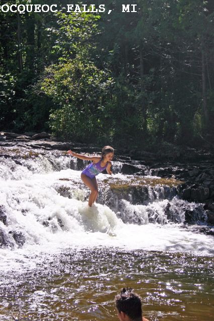
| TOWNS | MACKINAW CITY, ROGERS CITY, ONAWAY, MILLERSBURG | |
| LAT, LON | lat=45.39600, lon=-84.05775(source: DeLorme) (accuracy: exact) LINK TO GOOGLE MAP | |
| STATE | MI | |
| WATER | Ocqueoc River | |
| TYPE | Falls | |
| DESCRIPTION | This from a visitor: Here is one we always visit in Michigan, Kids love it, nice hiking trail nearby also. Not much space for real swimming, except to swim in place against the current, but fun jumping and wading, there are 2 sets of falls both with swimming holes below." There is a small gorge below the falls. See also GO WATERFALLING . | |
| AREAS | Black Lake S. F. (nearby) | |
| SANCTION | Unofficial | |
| FEE | Unknown | |
| FACILITIES | Unknown | |
| ACTIVITIES | Wading, water play | |
| PHONE | Unknown | |
| CAMPING | Very nearby at Black Lake S. F. . | |
| BATHING SUITS | Unknown | |
| DIRECTIONS | From Rogers City, take RT 68 west . Where RT 68 makes a sweeping left turn to the south, continue straight onto Ocqueoc Falls Rd. The falls are here. | |
| CONFIDENCE | Pretty confident | |
| VERIFIED | No | |
| DATE UPDATED | 2/15/2008 |
This swimming hole listing is by www.swimmingholes.org
|
| |
|---|---|---|
| TOWNS | DETROIT, ST. CLAIR | |
| LAT, LON | lat=42.8246, lon=-82.4852(source: DeLorme) (accuracy: approximate) LINK TO GOOGLE MAP | |
| STATE | MI | |
| WATER | St. Clair River | |
| TYPE | River | |
| DESCRIPTION | CAUTION: The St. Clair River has a serious current and swimming here is only for those who have learned to deal with it. Here, at Palmer Park in downtown St. Clair, there are a series of ladders spaced at about 50 yards, where you can get out of the current, which are used by locals who jump in upstream and use the ladders to get out. If you don't know how to use the ladders, you will be swept downstream. There are no lifeguards. The water is of dubious cleanliness. This may be a place to watch the locals and keep on shore. | |
| AREAS | None | |
| SANCTION | Unofficial | |
| FEE | None | |
| FACILITIES | Unknown | |
| ACTIVITIES | Swimming, jumping | |
| PHONE | Unknown | |
| CAMPING | Unknown | |
| BATHING SUITS | Unknown | |
| DIRECTIONS | From Detroit, take I-94 north to Fred W. Moore Rd. then east into St. Clair. Go to downtown St. Clair and to Riverside Ave. then to Palmer Park which is right on the river. | |
| CONFIDENCE | Pretty confident | |
| VERIFIED | No | |
| DATE UPDATED | 2/5/2009 |
This swimming hole listing is by www.swimmingholes.org
|
| |
|---|---|---|
| TOWNS | ANN ARBOR | |
| LAT, LON | lat=42.40981, lon=-83.98278(source: Measured By another) (accuracy: exact) LINK TO GOOGLE MAP | |
| STATE | MI | |
| WATER | Pickerel Lake | |
| TYPE | Lake | |
| DESCRIPTION | This from the DNR:
You may have a motorized boat on Pickerel Lake. If a person
launches their boat at Crooked Lake you may go into Pickerel with your motor
boat but you cannot launch a motorboat at Pickerel. | |
| AREAS | Pickney State Rec Area | |
| SANCTION | Official | |
| FEE |
Fee is $16 Recreation Passport required for Michigan license plates.
Non-Michigan plates are $9 for the day or $32 for the annual | |
| FACILITIES |
There is an outhouse on site | |
| ACTIVITIES |
Activities include fishing, boating, swimming, hunting | |
| PHONE |
Park phone is 734-426-4913 | |
| CAMPING |
No camping at that location, but available in designated campground nearby | |
| BATHING SUITS |
Bathing suits are required at all times | |
| DIRECTIONS | From Ann Arbor, take RT 23 north about 4.3 mi then take exit 49 for Territorial Rd and turn west (left) on N Territorial Rd and go 12.2 mi then turn north (right) at Hankerd Rd. into the Pinckney State Rec. Area. Pickerel lake is to the east of Hankerd Rd. No better directions to lake. | |
| CONFIDENCE | Pretty confident | |
| VERIFIED | No | |
| DATE UPDATED | 07/2018 |
This swimming hole listing is by www.swimmingholes.org
|
| |
|---|---|---|
| TOWNS | SAULT STE. MARIE, MUNISING, WETMORE | |
| LAT, LON | lat= 46.49606, lon=-86.53969(source: map) (accuracy: approximate) LINK TO GOOGLE MAP | |
| STATE | MI | |
| WATER | Lake Superior | |
| TYPE | Lake | |
| DESCRIPTION | Miner's Beach is in the Pictured Rocks National Lakeshore on the north side of the Upper Peninsula in a protected part of Lake Superior. Framed by the Pictured Rocks, it is a beautiful and little-used beach. | |
| AREAS | Pictured Rocks National Lakeshore | |
| SANCTION | Unofficial | |
| FEE | Unknown | |
| FACILITIES | All facilities at campgrounds nearby | |
| ACTIVITIES | Walking, swimming | |
| PHONE | Unknown | |
| CAMPING | Three campgrounds in the National Seashore, many others in the State Forest east of here | |
| BATHING SUITS | May be optional | |
| DIRECTIONS | From Munsing, go east on RT 58 (E. Munising Ave - becomes Adams Trail) then turn north (left) on RT 672 (Carmody Rd) and follow RT 672 through several turns for about 4 miles then turn north (left) on Miners Castle Rd and follow this road as it turns right then left then ends at Miner Rd.. Miners Beach is a short walk from the parking area here. | |
| CONFIDENCE | Very confident | |
| VERIFIED | No | |
| DATE UPDATED | 1/2014 |
This swimming hole listing is by www.swimmingholes.org
|
| |
|---|---|---|
| TOWNS | LANSING, GRAND RAPIDS, IONIA | |
| LAT, LON | lat= 42.97804, lon=-85.02254(source: map) (accuracy: approximate) LINK TO GOOGLE MAP | |
| STATE | MI | |
| WATER | Quarry Ponds | |
| TYPE | Quarry Ponds | |
| DESCRIPTION | Swimming and water play places in abandoned quarry ponds. There is a trail system (See red line on MAP above) that runs around the small shallow pond, for kids, and at the end of the trail, is a deep stone cut pond from the old sand stone quarry. Has a rope swing on and has some great jumping opportunities. (Lake swimming is also nearby at the Ionia State Recreation Area southwest of Ionia and Woodard Lake north of Ionia.) | |
| AREAS | None | |
| SANCTION | Unofficial | |
| FEE | None | |
| FACILITIES | None | |
| ACTIVITIES | Wading, swimming, rope swing | |
| PHONE | Unknown | |
| CAMPING | At Ionia State Recreation Area southwest of Ionia | |
| BATHING SUITS | Customary | |
| DIRECTIONS | From Ionia, go south across the river on Cleveland St. then take an immediate left (east) on East Riverside Dr.. Go about 2 miles then turn north (left) on Quarry Rd.. Drive to the end of this road and follow the trails to the ponds. | |
| CONFIDENCE | Pretty confident | |
| VERIFIED | No | |
| DATE UPDATED | 9/2014 |
This swimming hole listing is by www.swimmingholes.org
|
| |
|---|---|---|
| TOWNS | GRAND RAPIDS, TRAVERSE CITY | |
| LAT, LON | lat= 44.72905, lon=-86.1531(source: map) (accuracy: approximate) LINK TO GOOGLE MAP | |
| STATE | MI | |
| WATER | Platte River | |
| TYPE | River | |
| DESCRIPTION | Shallow stream winds through trees and sand dunes at Sleeping Bear Dunes National Lakeshore where it empties into Lake Michigan. Popular tubing place, kayaks, swimming and water play. | |
| AREAS | Sleeping Bear Dunes National Lakeshore | |
| SANCTION | Unofficial | |
| FEE | Unknown | |
| FACILITIES | All facilities at campground nearby | |
| ACTIVITIES | Tubing, kayaks, swimming, water play. | |
| PHONE | Unknown | |
| CAMPING | Two campgrounds in the National Seashore, many others in the State Forest east of here | |
| BATHING SUITS | Required | |
| DIRECTIONS | From Traverse City, go west on RT 72 (W. Traverse Hwy) for 13 miles then turn south (left) on RT 669 (Maple City Hwy) for about 4 miles then turn west (right) on Almira Rd. then very shortly north (right) on RT 610 (Rayle Rd - becomes Fowler Rd) for about 6 miles then south (left) on RT 22 (Northland Hwy - becomes N. Scenic Hwy) for about 5 miles then turn right on RT 708 (Lake Michigan Rd) (at the Platte River Campground). Continue past the campground a to the end of the road at the Platte River and Lake Michigan. The swimming place is here in the Platte River. | |
| CONFIDENCE | Very confident | |
| VERIFIED | No | |
| DATE UPDATED | 1/2014 |
HOME