See a SLIDESHOW of swimming hole photos in this state.
This swimming hole listing is by
www.swimmingholes.org
BEAVER DAM
(BEAV)
| |
|---|
|
TOWNS | BALTIMORE, HUNT VALLEY |
|---|
| LAT, LON | lat=39.47931, lon=-76.65703(source: DeLorme) (accuracy:exact)
LINK TO GOOGLE MAP |
|---|
|
STATE | MD |
|---|
|
WATER | Quarry |
|---|
|
TYPE | Quarry |
|---|
|
DESCRIPTION | This is a commercial swim club with some unique features. A
filled quarry with diving floats and rope swings. See their web site for fees, hours, etc: BEAVER DAM SWIM CLUB.
Things have unfortunately changed here - I received this in 6/2005: "Thanks for your website. I was a season pass holder at Beaver Dam Swimming Club in MD from 1991 to 2002. In early 2002 they closed off about 1/4 of the shimming hole. In 2003 to present they closed off more than 3/4 of the hole. Now only the corner is open near the rope swing, even the cliffs are roped off. The roped off portion includes one of the logs. The reason for closing it off was 1) lost lawsuits and 2) Baltimore County regulations. My problem (aside from missing my summer swimming) is that neither Baltimore Magazine(who listed it last month) , your website, or the Beaver Dam website(link below) mention this. In fact they post old pictures on their website that indicate that long closed portions of the swimming hole are open. I wish you would indicate this on your website."
|
|---|
|
AREAS | None |
|---|
|
SANCTION | Official |
|---|
|
FEE | Yes |
|---|
|
FACILITIES |
Picnic tables, rest rooms, snack bar |
|---|
|
ACTIVITIES |
Swimming, Diving, Rope Swing |
|---|
|
PHONE | (410)785-1826 |
|---|
|
CAMPING | Unknown |
|---|
|
BATHING SUITS | Required |
|---|
|
DIRECTIONS | From Baltimore, take I-95 N to I-695 W toward Towson. Take I-83
north to exit 18 (Warren Rd. ) go left at Beaver Dam Rd.. |
|---|
|
CONFIDENCE | Highly confident |
|---|
|
VERIFIED | no |
|---|
|
DATE UPDATED | 6/22/2005 |
|---|
This swimming hole listing is by
www.swimmingholes.org
BETTERTON BEACH
(BETT)
|
|
|---|
|
TOWNS | CHESTERTOWN, BETTERTON |
|---|
|
LAT, LON | lat=39.37083, lon=-76.06667(source: Topozone) (accuracy:approximate)
LINK TO GOOGLE MAP |
|---|
|
STATE | MD |
|---|
|
WATER | Sassafras River |
|---|
|
TYPE | River (Tidal) |
|---|
|
DESCRIPTION | A public, sandy County beach on Sassafras River where it empties into the Chesapeake Bay. This is a tidal river, like swimming in the Bay, but in years of normal rainfall the water here is too fresh for the jellyfish that plague the lower Chesapeake Bay. Check before you swim here - there are sometimes pollution alerts for this part of the bay. Betterton Beach Web Site.
|
|---|
|
AREAS | Eastern Shore |
|---|
|
SANCTION | Official County beach |
|---|
|
FEE | No |
|---|
|
FACILITIES |
Picnic tables, bath house, free parking. County Picnic Pavilion, restaurant overlooking bay called Five Rivers Tavern, snack bar. Country store called the Still Pond Store with sandwiches etc., located in Still Pond, 3 miles from beach. |
|---|
|
ACTIVITIES |
Swimming, canoe-kayak and cartop boat launching, fishing (state license needed).
|
|---|
|
PHONE | Unknown |
|---|
|
CAMPING | Try Bay Country Campground, near Rock Hall, or Duck Neck Campground south of Chestertown
410-778-3070 |
|---|
|
BATHING SUITS | Required |
|---|
|
DIRECTIONS | From Chestertown (on Maryland's Eastern Shore) take RT 213 north then RT 297 north to Worton. Turn right on RT 298 east. Turn left on RT 292 west. Turn left in Still Pond. Betterton is 3 miles from the crossroads. |
|---|
|
CONFIDENCE | Highly confident |
|---|
|
VERIFIED | Yes, 6/99 |
|---|
|
DATE UPDATED | 6/2010 |
|---|
This swimming hole listing is by
www.swimmingholes.org
CAMP HARDING PARK
(CAMH)
|
|
|---|
|
TOWNS | HAGERSTOWN, BERKELEY SPRINGS (WV), PECKTONVILLE |
|---|
|
LAT, LON | lat=39.66924, lon=-78.04293(source: map) (accuracy:approximate)
LINK TO GOOGLE MAP |
|---|
|
STATE | MD |
|---|
|
WATER | Licking Creek |
|---|
|
TYPE | Creek |
|---|
|
DESCRIPTION | This from a visitor:� Now a county park, with long-time swimming hole adjacent to park where the slope of the creek gets deeper and deeper slowly like a large Olympic pool. Maybe 8-10 foot deep at the hole. At times the health department will post swimming is dangerous (too many farms north and south). We swam there as kids and now as adults.... incredible beauty. Named Camp Harding after the president who would camp there. There's a photo of Harding Firestone and Henry Ford all camping there together.... not sure if photo is online anywhere. County park does not include swimming hole so it does not list it as such. Holes sits adjacent to the park. At times there's a rope swing off a huge old oak tree.... way too much fun." CAMP HARDING PARK WEB SITE. |
|---|
|
AREAS | Camp Harding Park |
|---|
|
SANCTION | Unofficial (swimming hole is not actually in the park) |
|---|
|
FEE | None |
|---|
|
FACILITIES | At county park |
|---|
|
ACTIVITIES |
Water play, Swimming |
|---|
|
PHONE | Unknown |
|---|
|
CAMPING | None at site. |
|---|
|
BATHING SUITS | Customary |
|---|
|
DIRECTIONS | From Hagerstown, take RT 40 west (parallels I-70) for about 20 miles, turn right onto Pectonville Rd and go about 1 mile then turn right into Camp Harding Park. The swimming hole is just behind (south of) the park. No better directions. |
|---|
|
CONFIDENCE | Pretty confident |
|---|
|
VERIFIED | No |
|---|
|
DATE UPDATED | 2/2013 |
|---|
This swimming hole listing is by
www.swimmingholes.org
CASCADE LAKE
(CASC)
|
|
|---|
|
TOWNS | WESTMINSTER, HAMPSTEAD |
|---|
|
LAT, LON | lat=39.61636, lon=-76.89000(source: Topozone) (accuracy:exact)
LINK TO GOOGLE MAP |
|---|
|
STATE | MD |
|---|
|
WATER | Unknown |
|---|
|
TYPE | Lake |
|---|
|
DESCRIPTION | CASCADE LAKE WEB SITE. |
|---|
|
AREAS | None |
|---|
|
SANCTION | Official |
|---|
|
FEE | Yes, see web site |
|---|
|
FACILITIES | All |
|---|
|
ACTIVITIES |
Swimming, water slide, petting zoo, fishing |
|---|
|
PHONE | (410) 374-9111 |
|---|
|
CAMPING | None at site. |
|---|
|
BATHING SUITS | Required |
|---|
|
DIRECTIONS | From Baltimore take: I-695, exit 19 to I-795 north to RT 30 north to Hampstead, left on RT 482, right on Snydersburg Road. |
|---|
|
CONFIDENCE | Very confident |
|---|
|
VERIFIED | No |
|---|
|
DATE UPDATED | 11/8/2004 |
|---|
This swimming hole listing is by
www.swimmingholes.org
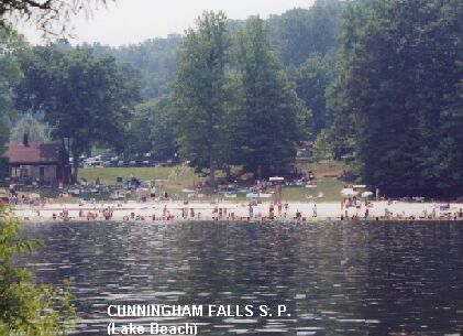
CUNNINGHAM FALLS S. P.
(CUNN)
| |
|---|
|
TOWNS | FREDERICK, THURMONT |
|---|
|
LAT, LON | lat=39.63139, lon=-77.47167(source: Topozone) (accuracy:exact)
LINK TO GOOGLE MAP |
|---|
|
STATE | MD |
|---|
|
WATER | Unknown |
|---|
|
TYPE | Waterfall |
|---|
|
DESCRIPTION | Seventy eight foot high cascading falls, has numerous pools for dipping. PHOTO AT FALLS. Cold water, rocks can be slippery, be very careful. (Not for small children - take them the lake for "official" swimming.) Brief hike to falls,
wheelchair access to bottom of falls. Swimming in falls is not
officially sanctioned. Official swimming lake is nearby in the S.P. PHOTO OF LAKE. Web site: CUNNINGHAM FALLS S. P. |
|---|
|
AREAS | Cunningham Falls S.P. |
|---|
|
SANCTION | Unofficial |
|---|
|
FEE | Yes |
|---|
|
FACILITIES (at lake) |
Toilet,
Changing room,
Picnic tables, |
|---|
|
ACTIVITIES |
Swimming, |
|---|
|
PHONE | (301)271-7574 |
|---|
|
CAMPING | Camping at state park, reservations available, very well
developed. Some sites are "camper ready" with tents, stoves, etc
provided. Call (301)271-7574. |
|---|
|
BATHING SUITS | Customary |
|---|
|
DIRECTIONS | From Frederick, follow RT 15 N for about 15 mi to
signs for Cunningham Falls S.P. |
|---|
|
CONFIDENCE | Very confident |
|---|
|
VERIFIED | yes |
|---|
|
DATE UPDATED | 6/30/1999 |
|---|
This swimming hole listing is by
www.swimmingholes.org
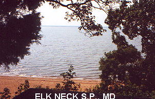
ELK NECK S. P.
(ELKN)
| |
|---|
|
TOWNS | WILMINGTON (DE), ELKTON, NORTHEAST |
|---|
|
LAT, LON | lat=39.50278, lon=-75.97917(source: Topozone) (accuracy:approximate)
LINK TO GOOGLE MAP |
|---|
|
STATE | MD |
|---|
|
WATER | Chesapeake Bay |
|---|
|
TYPE | Bay |
|---|
|
DESCRIPTION | A large, public, sandy beach on the northern reaches of the Chesapeake Bay. Not really a swimming hole, but attractive because the jellyfish that plague the lower Chesapeake don't reach up this far..
NOTE: In 8/2007, a Washington Post article noted that upper Chesapeake Bay beaches frequently exceed pollution levels for human and animal waste. We DO NOT recommend swimming here unless you have specific information that it is acceptably clean here at the time you are visiting. |
|---|
|
AREAS | Elk Neck S. P. |
|---|
|
SANCTION | Official |
|---|
|
FEE | Yes, $2.00 per vehicle |
|---|
|
FACILITIES |
Picnic tables, toilets, playground |
|---|
|
ACTIVITIES |
Swimming |
|---|
|
PHONE | 410-287-5333 |
|---|
|
CAMPING | At site, also cabins to rent. |
|---|
|
BATHING SUITS | Required |
|---|
|
DIRECTIONS | From Wilmington DE, go south on I-95 (toll) to exit 100 then take RT 272 south to the state park. |
|---|
|
CONFIDENCE | Highly confident |
|---|
|
VERIFIED | Yes, 6/99 |
|---|
|
DATE UPDATED | 8/8/2007 |
|---|
This swimming hole listing is by
www.swimmingholes.org
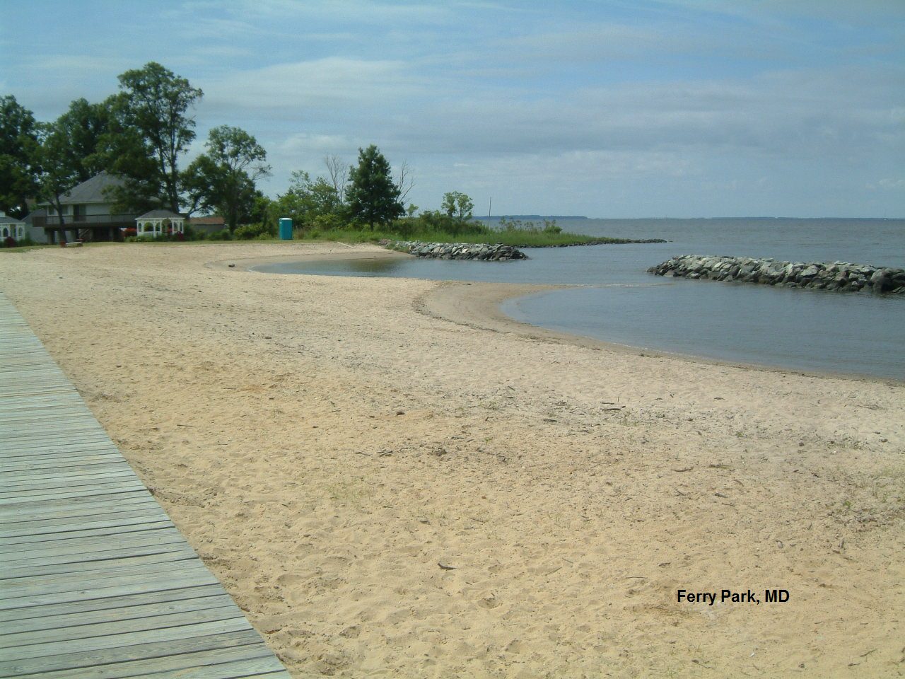
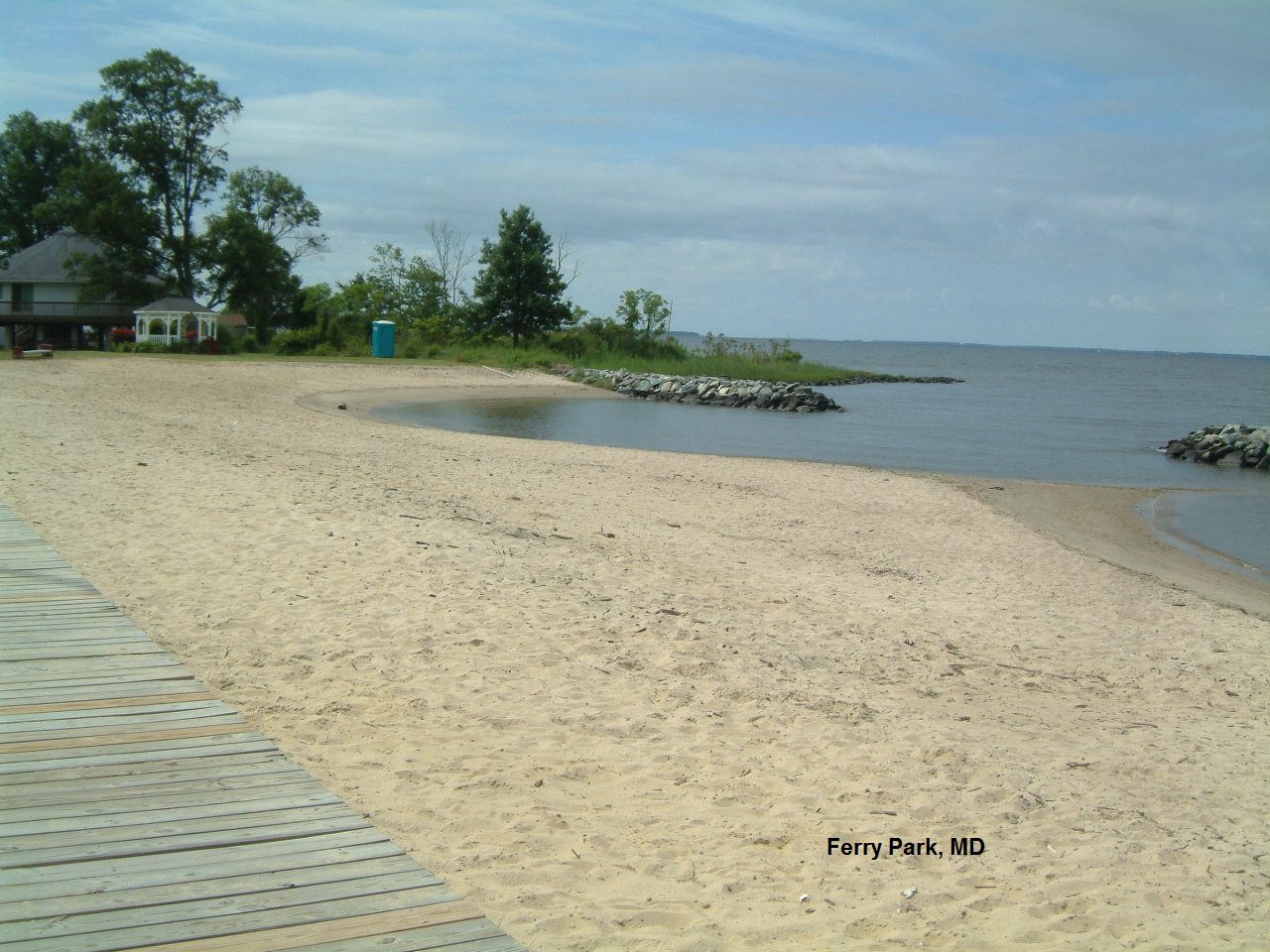
FERRY PARK
(FERR)
|
|
|---|
|
TOWNS | CHESTERTOWN, ROCK HALL |
|---|
|
LAT, LON | lat=39.139431, lon=-76.25767(source: map) (accuracy:approximate)
LINK TO GOOGLE MAP |
|---|
|
STATE | MD |
|---|
|
WATER | Chesapeake Bay |
|---|
|
TYPE | Bay |
|---|
|
DESCRIPTION | A small public, fine-sand beach on the Chesapeake Bay at the mouth of the Chester River is the swimming area for the town of Rock Hall. Check before you swim here - there are sometimes pollution alerts for this part of the bay and there may be jellyfish present in large number. Rock Hall Info. Fabulous sunsets! |
|---|
|
AREAS | Eastern Shore |
|---|
|
SANCTION | Official town beach |
|---|
|
FEE | No |
|---|
|
FACILITIES | Picnic tables, toilets, changing room, gazebos. |
|---|
|
ACTIVITIES |
Swimming, picnicking, sunsets |
|---|
|
PHONE | Unknown |
|---|
|
CAMPING | None at site |
|---|
|
BATHING SUITS | Required |
|---|
|
DIRECTIONS | From Chestertown (on Maryland's Eastern Shore), take RT 20 West to Rock Hall. Continue through the blinking light on Route 20 to where the road ends. Turn left on Beach Rd. Go about 1/2 mile. |
|---|
|
CONFIDENCE | Very confident |
|---|
|
VERIFIED | Yes, 6/2013 |
|---|
|
DATE UPDATED | 6/2013 |
|---|
This swimming hole listing is by
www.swimmingholes.org
GREEN RIDGE S. F. AREA
[4 PLACES]
(GREE)
| |
|---|
|
TOWNS | HANCOCK, CUMBERLAND, LITTLE ORLEANS |
|---|
|
STATE | MD |
|---|
|
WATER | Fifteen Mile Creek |
|---|
|
TYPE | Creek |
|---|
|
DESCRIPTION | Swimming holes in Fifteen Mile Creek in the Green Ridge State Forest (and nearby) in western Maryland NOTE: In all cases, getting a map from Green Ridge S.F. Ranger's Station is a necessity! The Ranger Station is at Exit 64 (near GREEN RIDGE 3 below). Green Ridge S.F. Web Site. See also nearby in West Virginia: MOUNT STORM AREA .
See "DIRECTIONS" below for details. |
|---|
|
AREAS | Green Ridge State Forest |
|---|
|
SANCTION | Unofficial |
|---|
|
FEE | None |
|---|
|
FACILITIES |
None |
|---|
|
ACTIVITIES |
Swimming (Tubing in Potomac River, at Green Ridge 4 below) |
|---|
|
PHONE | 301-478-3124 |
|---|
|
CAMPING | There are 100 primitive camping sites (no tables or toilets, $7.00)in the State Forest; get a permit at the State Forest Visitor's Center at Exit 64. Can also camp at the C&O Canal at GREEN RIDGE 4 (see below, tables and Johnny toilets, $10.00). For luxury, go west 15 miles on I-68 to Rocky Gap S.P., expensive camping but very nice - on a big lake with swimming and boating and a lodge. |
|---|
|
BATHING SUITS | Varies, see below |
|---|
|
DIRECTIONS | From Hancock, take I-68 west. Then:
|
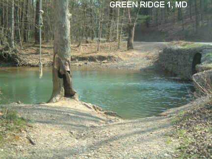
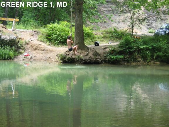
GREEN RIDGE 1 [GRE1]: Near the town of Flintstone in Fifteen Mile Creek is a not terribly scenic but convenient and fun swimming hole with rope swing (someone usually puts one up every year). This place may have no water later in the summer. PHOTO 1, PHOTO 2 . Not really in the State Forest but nearby. Bathing suits customary (it is a local hangout). To get here: From I-68, take Exit 62 (Scenic 40 and Fifteen Mile Creek Rd) and go north onto Scenic RT 40. At about a mile, Scenic 40 will curve to the right. Go left onto Fifteen Mile Creek Rd (gravel). At approximately .8 miles, the swimming hole will be on the right, at a culvert/bridge just past Carpenter Rd.. LAT, LON : lat=39.6934, lon= -78.4523(source: measured) (accuracy: exact) LINK TO GOOGLE MAP. Very confident. Verified 4/04. Updated 4/04.
| |
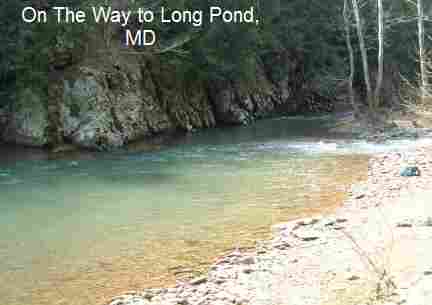
GREEN RIDGE 2 [GRE2]: Near the town of Little Orleans in Fifteen Mile Creek are a series of pools along the creek. Also an outstanding large pool called Longs Pond. Great informal (backpack) camping spots. Bathing suits may be optional in places. To get here: From I-68, take Exit 62 (Scenic 40 and Fifteen Mile Creek Rd). Go south on Fifteen Mile Creek Rd (gravel, sometimes rough but passable in a car) for 2.6 miles, keeping left at all decision points (e.g., do NOT go onto Greenridge Rd.) At 2.6 miles (past campsite #55 but BEFORE campsite #56) you will go down a hill and cross a creek and see a trailhead on the immediate other side of this bridge.
Park here. There is a trail information sign here saying �Long Pond Ridge Trail.� Take the trail downstream (left) along a stream (it is not Fifteen Mile Creek, yet). The trail is marked red on the maps and also is marked red on the trees. Walk about .6 miles to where the trail splits. The red trail (Long Pond Ridge Trail) continues to the right; a
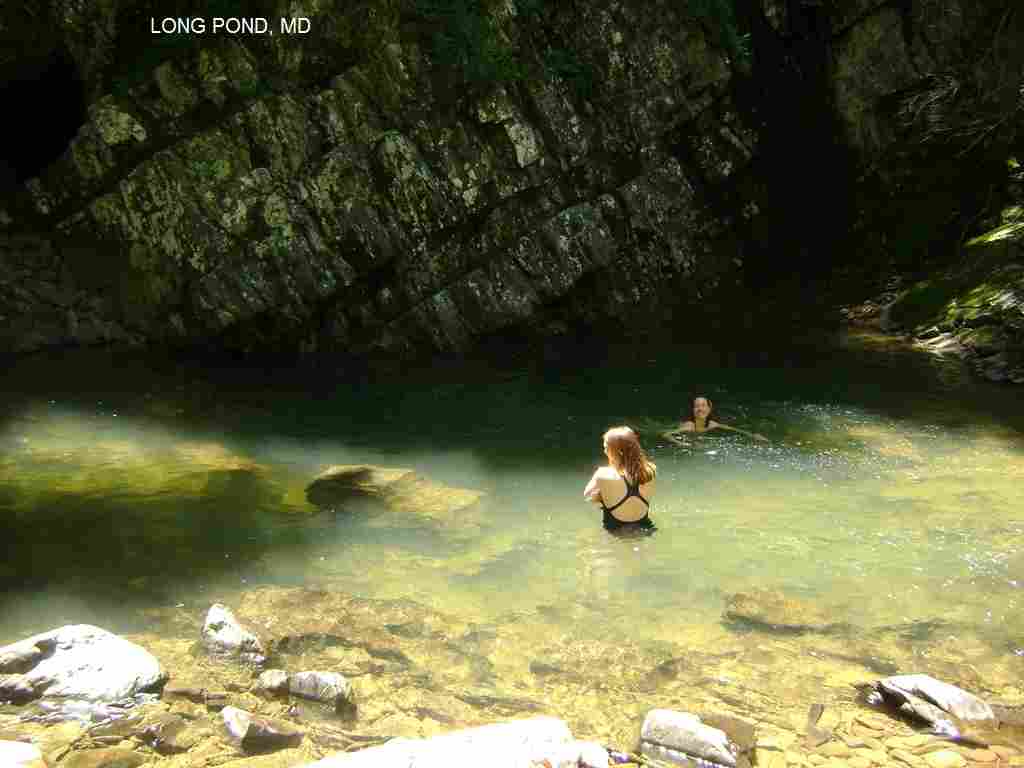
blue-blazed trail goes to the left after crossing a stream. From here, there appear to be two ways to go toward Long Pond - the "Bushwack" way and the "Long Pond Ridge Trail" way (below) - neither one is clearly better. Long's Pond: LAT, LON : lat=39.65842, lon= -78.44737(source: measured) (accuracy: exact) LINK TO GOOGLE MAP .
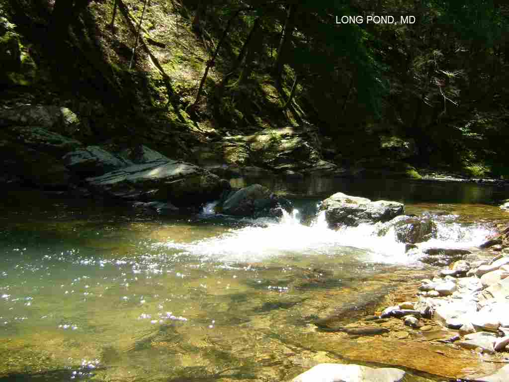
Bushwack: If you take the blue-blazed trail you will soon come to a trail registry. In a short distance, when the trail begins to go steeply uphill. Here, leave the trail and wade across the creek and bushwhack pretty much straight downstream - there is an old overgrown road here which you are roughly following. (Keep on the lookout for snakes and use long pants and/or deet to repel ticks along the bushwacking parts of the trail.) You will bushwack for about 20 minutes, passing some wading/swimming places (and campsites) that are NOT Long Pond NOT LONG POND, then you will come to Long Pond itself which is a wide and deep spot on Fifteen Mile Creek with pronounced diagonally sloping rock strata on the rock bluff on the far side. LONG POND , LONG POND. There is a nice shady picnic area/campsite set up with natural stones to make seats. Pretty confident. Partially verified 4/04. Updated 6/2010.
Long Pond Ridge Trail: At the trail split, you continue on the red trail, "Long Pond Ridge Trail", and it rises very steeply, and the hike continues along the ridge before going down to the creek. From where the red and blue trails split to the bottom of the ridge is about a mile. Expect a steep, tiring hike of about 30 minutes from where the trails split - to be avoided unless you have good hiking shoes. When you finish the descent from the ridge, then you will see a 1.6 mile marker. Long Pond is maybe a hundred yards from there on the left. There is a path leading to it where people have set up a picnic area/campsite, so it is easy to spot. The water (in early June) was about 5 feet deep in a few places. As for bathing suits, the �Pond� is secluded in general, but not from the trail. Anyone hiking the red trail would be able to see. Pretty confident. Not verified. Updated 6/2010.
GREEN RIDGE 3 [GRE3]: Swimming hole where 15 mile Creek dumps into the Potomac River. There is a boat ramp and there is usually a rope swing attached. The water is
between 4' and 8' deep, depending on area and water level. The C&O Canal towpath allows you to cross the creek so you can enter the water on either side. You can swim in the creek or in the Potomac and even cross over to West Virginia.PHOTO. NOTE: Only adults who are also strong swimmers should enter the main stream of the Potomac, as the current is very strong. Sharing the area with locals and fishermen needs to be taken into account. For rafting / tubing, hike up the
Potomac on the C&O Canal towpath as far as you want and you can raft down the Potomac back to your car.
To get here: From MD I-68 take Exit 68 and go south on Orleans Road for about 6 miles. After 6 miles, take a left (east) at an intersection, where the signs point to the C&O Canal (right/straight continues west as Oldtown Orleans Rd). Pass by a small country store and outfitter shop called "Bill's Place", pass under railroad tracks, and turn right immediately. Turn left at the campground entrance and cross the wooden bridge over the C&O canal. There is
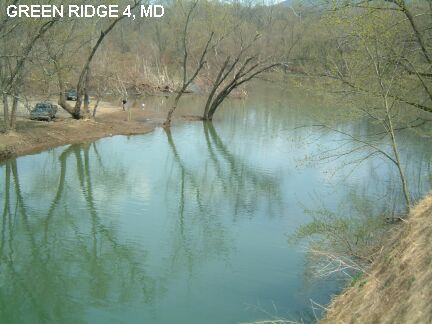
plenty of parking and several fee camping spots, with self-registration at $10 a night. (Recommend camping at one of the many camping spots at Green Ridge State Forest, which are more private ($7 a night). LAT, LON : lat=39.62412, lon= -78.38626(source: measured) (accuracy: exact) LINK TO GOOGLE MAP. Very confident. Verified 4/04. Updated 4/04.
TOWN CREEK [TOWN]: Nice small swimming hole in Town Creek (near where it empties into the Potomac River) that is 7-10 feet deep with a rock formation to jump off of with jumps at 8, 15 and 25 feet. To get here from I-68 in Cumberland, take RT 51 south for 20-25 miles. After you cross Town Creek (steel bridge) go about another .6 mile to a sign on the right that says �Town Creek Aquaduct/ C & O Canal entrance�. Turn right on to this access road and go until you come to the barricade at the end. About 200 yards before the barricade you will see a trail going down to your right. Walk down here and you will find the swimming hole. A great place on a hot day..
LAT, LON : lat=39.52437, lon= -78.5441(source: map) (accuracy: approximate) LINK TO GOOGLE MAP. Pretty confident. Not verified. Updated 2/2011.
|
|---|
|
CONFIDENCE | Varies - see above |
|---|
|
VERIFIED | Partially, 4/04 |
|---|
|
DATE UPDATED | 2/2011 |
|---|
This swimming hole listing is by
www.swimmingholes.org
GUNPOWDER FALLS S. P.-HEREFORD AREA
[4 PLACES]
(GUNH)
|
|
|---|
|
TOWNS | BALTIMORE, HEREFORD, MONKTON |
|---|
|
LAT, LON | lat=39.6108, lon=-76.6806(source: DeLorme) (accuracy:general area)
LINK TO GOOGLE MAP |
|---|
|
STATE | MD |
|---|
|
WATER | Big Gunpowder Creek |
|---|
|
TYPE | Creek |
|---|
|
DESCRIPTION | Gunpowder Falls S.P. is comprised of separate parks where you can access the Gunpowder Falls River via several trails. This one, which is called the "HEREFORD AREA", is up I-83 north of Baltimore. It includes several river access points and trails, several with swimming places. I name these (below) by the road from which you access the river. See directions below for details. |
|---|
|
AREAS | Gunpowder Falls S.P. |
|---|
|
SANCTION | Unofficial |
|---|
|
FEE | No |
|---|
| FACILITIES |
Toilets, picnic tables at Bunker Hill, nothing at the other points |
|---|
|
ACTIVITIES |
Swimming, Tubing |
|---|
|
PHONE | (410)592-2897 Gunpowder Falls S.P.
|
|---|
|
CAMPING | None at site. Continue up I-83, just past York, PA follow signs to
Gifford Pinchot S.P.. Great camping and lake swimming. |
|---|
|
BATHING SUITS | Customary |
|---|
|
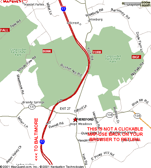
DIRECTIONS | From Baltimore, take I-83 north to exit 27 (RT 137, Hereford). From here:
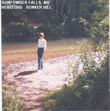
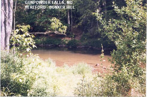
BUNKER HILL RD. [BUNK]: Go east (right) at the bottom of the ramp onto RT 137. Then north (left) onto York Rd. RT 45). Go about 1 mi to just past Hereford High School (on the right) to Bunker Hill Rd. on the left. Go left onto Bunker Hill Rd. which ends at a parking lot for Gunpowder Falls S. P. and a picnic area. Walk upstream (left) on the south side of the river, keeping on the trail closest to the stream. After you get through the picnic area (about a 5 min. walk altogether), there is a deep swimming hole in the stream with a beach area. LAT, LON: lat=39.612855, lon=-76.676311(source: map) (accuracy: approximate) LINK TO GOOGLE MAP. BUNKER HILL RD. PHOTO 1 - PHOTO 2
YORK RD. [YORK]: Continue north on York Rd. past Bunker Hill Rd. until you reach the bridge over Gunpowder Falls River. Park on either side of York Rd. south of the bridge (before you cross the bridge.)
The most easily accessible place here is "Hobo Beach". It is right near the parking area with a grassy lawn and deep swimming place on the far side of the creek with a rope swing and large rock. Cold water! Popular spot for ending tubing trips down the Gunpowder. LAT, LON: lat=39.61428, lon=-76.65908(source: map) (accuracy: general area) LINK TO GOOGLE MAP.
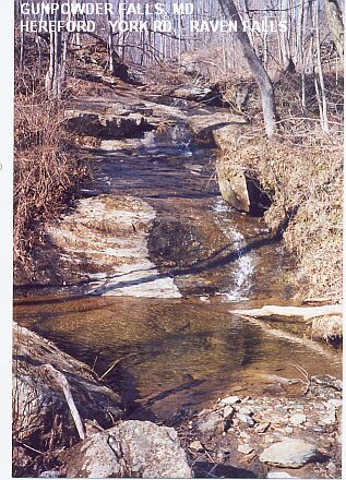
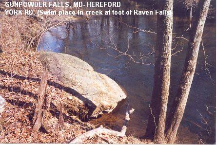
For other places, walk north along York Rd. across the bridge (carefully, there is no sidewalk.) After you cross the bridge, on the east (right) side of the road there is a sign saying "Wiseburg". At this sign, there is a trail going down steeply toward the river. Where you first reach the river is an apparent swimming place by a couple of large rocks. Continue on this trail (blue blazes) downstream (this is the Gunpowder Falls North trail, it is a very easy and pretty walk) for about 30 minutes and you will come to Raven Falls (a very small but picturesque falls)YORK RD. PHOTO 1
entering the river from the left. There is a small pool at the very bottom of the falls but a better swimming hole is there in the Gunpowder Falls River where a large rock goes down to the water.YORK RD. PHOTO 2
Another trail: Across York Rd. from the Wiseburg sign there is another trail going down to the river and following it in the upstream direction. There is said to be a local swimming hole a short distance down this trail but I did not see any real swimming places on a visit 2/20/01, except maybe right under the I-83 bridge, but it is very noisy and not very scenic there.
BIG FALLS RD. [BIGF]: From RT 137 in Hereford, go south on York Rd. (RT 45) a short distance then east (left) on Monkton Rd.(RT 138) Take Monkton Rd through Hereford to Big Falls Rd on the left (before Monkton). Turn left on Big Falls Rd, bear right at the "T" intersection to stay on Big Falls Rd. Just before Big Falls Rd crosses the river, park here and walk upstream on the south side of the river (the Gunpowder Falls South Trail). LAT, LON: lat=39.60886, lon=-76.63513(source: map) (accuracy: general area) LINK TO GOOGLE MAP. There are several deep swimming holes here, tubing also. Rental of tubes at the train station in Monkton.
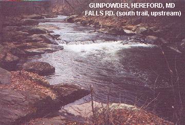
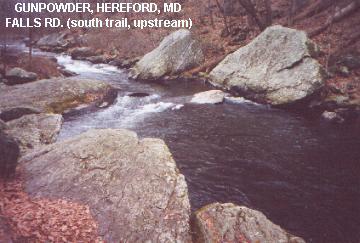
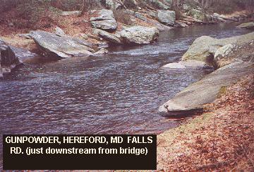
FALLS RD. [FALL]: From Exit 27, go west (left) at the bottom of the ramp onto RT 137 (Mount Carmel Rd.). Continue past several roads and turn north (right) on Evna Rd.. Follow Evna Rd. and turn right on Falls Rd.. As Falls Rd. descends to the Gunpowder Falls River, park in the last parking area on the left just before you cross the bridge. AT, LON: lat=39.61875, lon=-76.69075(source: map) (accuracy: general area) LINK TO GOOGLE MAP. A trail begins in this parking area (designated the Gunpowder Falls South Trail) and goes down to the river then heads upstream on the south side of the river. There are several deep places with large rocks and small falls for swimming in the first 10-15 minutes of this walk.FALLS RD. PHOTO 2 - PHOTO 3 (The trail gets rocky and narrow if you go further and there are no apparent swimming places further up.) There is also an apparent swimming place just downstream from this bridge. FALLS RD. PHOTO 1
|
|---|
|
CONFIDENCE | Very confident |
|---|
|
VERIFIED | yes, 2/21/01 |
|---|
|
DATE UPDATED | 2/21/01 |
|---|
This swimming hole listing is by
www.swimmingholes.org
GUNPOWDER FALLS S. P.-CENTRAL AREA
[7 PLACES]
(GUNC)
|
|
|---|
|
TOWNS | BALTIMORE, PERRY HALL, BENSON, BALDWIN |
|---|
|
STATE | MD |
|---|
|
WATER | Varies-see below |
|---|
|
TYPE | Creek/River |
|---|
|
DESCRIPTION | Gunpowder Falls S.P. is comprised of separate parks where you can access the Gunpowder Falls River and the Little Gunpowder River via several trails. This one, which is called the "CENTRAL AREA", is up RT 1 northeast of Baltimore. |
|---|
|
AREAS | Gunpowder Falls S.P. |
|---|
|
SANCTION | Unofficial |
|---|
|
FEE | No |
|---|
|
FACILITIES |
None |
|---|
|
ACTIVITIES |
Swimming |
|---|
|
PHONE | (410)592-2897 Gunpowder Falls S.P.
|
|---|
|
CAMPING | None at site. Susquehanna S. P. and Elk Neck S. P., both northeast of here, have camping. Elk Neck also has swimming in the Chesapeake Bay. |
|---|
|
BATHING SUITS | Customary |
|---|
|
DIRECTIONS | From the Baltimore beltway, I-695, take Exit 32 and go north on RT 1, then:
LONG GREEN CREEK [LONG]: AKA "The Pool". (See also "POT ROCKS" below which are accessed from the same parking area). This swimming hole is in a tributary creek (Long Green Creek) that empties into the Gunpowder Falls River. LINK TO AN ARTICLE ABOUT THIS PLACE. To get here from the Baltimore Beltway (I-695) north of Baltimore take RT 1 (Belair Rd.) north about 5.5 miles. Just after RT 1 crosses the bridge over the Gunpowder Falls River there is a large parking area on the right (east) side of RT 1. LAT, LON (parking area): lat=39.4276, lon= -76.4433(source: measured) (accuracy: exact) LINK TO GOOGLE MAP. Park here and look at the large trail map painted on the sign in the parking lot. Near the right hand edge of this map, see an area marked "POOL" in "LONG GREEN CREEK". This is the swimming hole.
This report from a visitor in 2007:"Just visited this swimming hole about two weeks ago. I planned my own circuit hike that finished up at the swimming hole, then followed the trail you described back to the parking lot. It's there, with some nice rocks for sunning afterward. The water isn't particularly deep, but enough to swim around. Mostly smooth rocks and some mucky stuff on the bottom - I didn't have water shoes but didn't have a problem. There weren't many other people when I got there, but as I stayed more and more people showed up. Probably not a private spot on a hot weekend afternoon, but I enjoyed the dip after nearly 10 miles of hiking."
To get here: Follow the trail as described in this map - go under RT 1 then upstream along the north shore of the river. There are various trails that go off to the right - DO NOT TAKE THESE; stay on the trail that runs along the river. At about 1.2 miles, the trail will encounter Long Green Creek and bend to the right. The swimming hole is near here in Long Green Creek. (May be too shallow to swim at some water levels.)LAT, LON (swimming hole): lat=39.43758, lon= -76.46314(source: DeLorme) (accuracy: approximate) LINK TO GOOGLE MAP. Very confident. Verified 4/04. Updated 4/04.
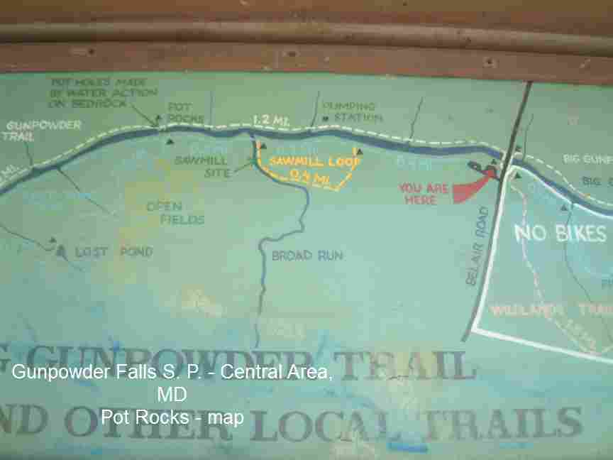
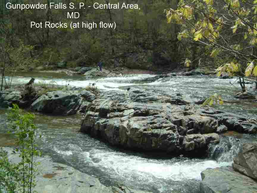
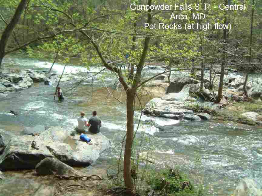
POT ROCKS [POTR]:(See also "LONG GREEN CREEK" above which is accessed from the same parking area). 1.2 mile easy hike (each way) to rocks and rapids in the middle of the Big Gunpowder Falls River. PHOTO OF MAP , PHOTO , PHOTO . The rocks form a little pool (where pot holes were created in the bedrock from water action) that is a great place to go for a dip. Nice place to go near sunset on a hot summer day (park closes at sunset). LINK TO AN ARTICLE ABOUT THIS PLACE.
To get here from the Baltimore Beltway (I-695) north of Baltimore take RT 1 (Belair Rd.) north about 5.5 miles. Just after RT 1 crosses the bridge over the Gunpowder Falls River there is a large parking area on the right (east) side of RT 1. (same parking area as for LONG GREEN CREEK above) LAT, LON (parking area): lat=39.4276, lon= -76.4433(source: measured) (accuracy: exact) LINK TO GOOGLE MAP. Park here and look at the large trail map painted on the sign in the parking lot. On the left side of this map, see an area marked "POT ROCKS". This is the swimming hole. Park and follow the blue blazed trail heading southeast from the parking lot (downstream) on the north side of the river. After walking less than a mile, you come to a trail crossing. To the left is the continuation of the Lost Pond Trail, which leads you up the hillside. Keep right here at the trail marker (keep near the river, still following the blue blazes) and continue hiking for about ten minutes to the Pot Rocks (there is a sign post) which are rocks in the middle of the river. LAT, LON: lat=39.418, lon=-76.429(source: measured) (accuracy: exact) LINK TO GOOGLE MAP. Very confident. Verified 4/2011. Updated 4/2011.
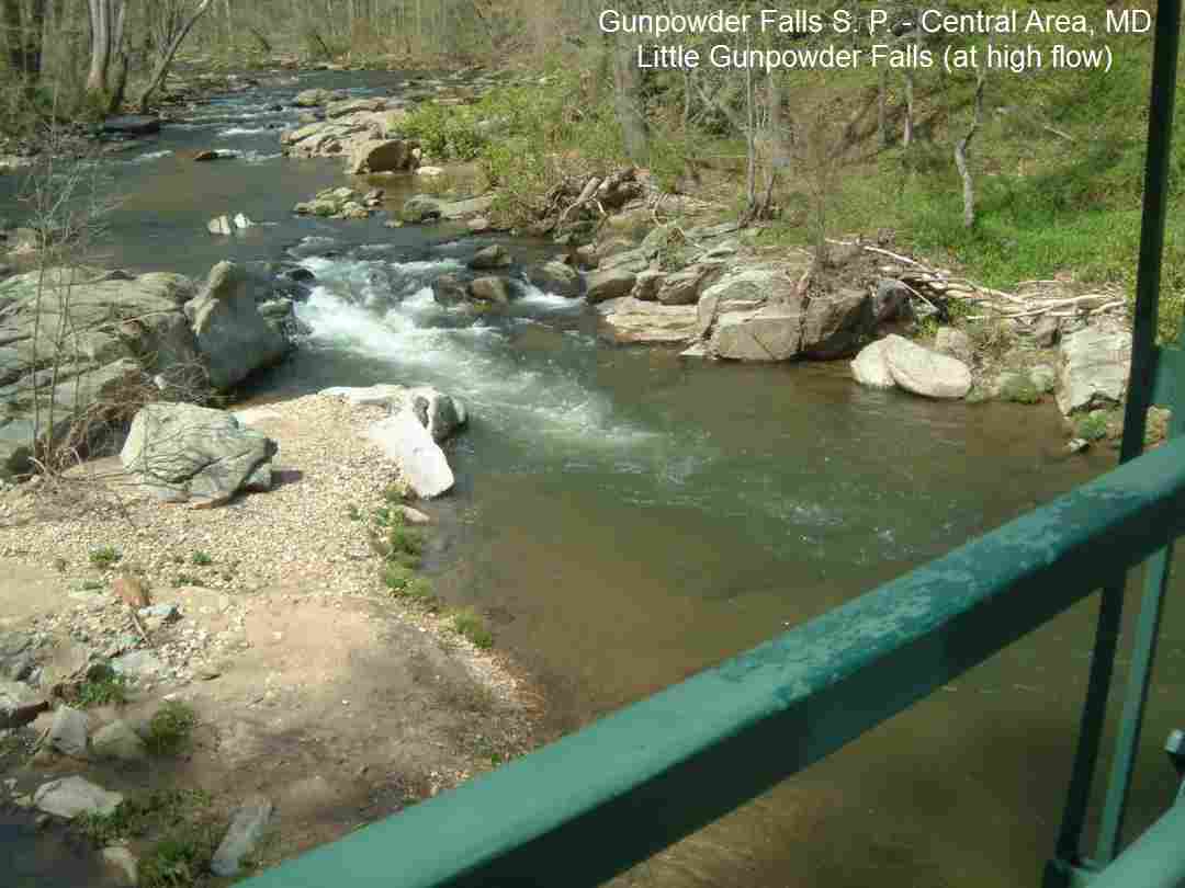
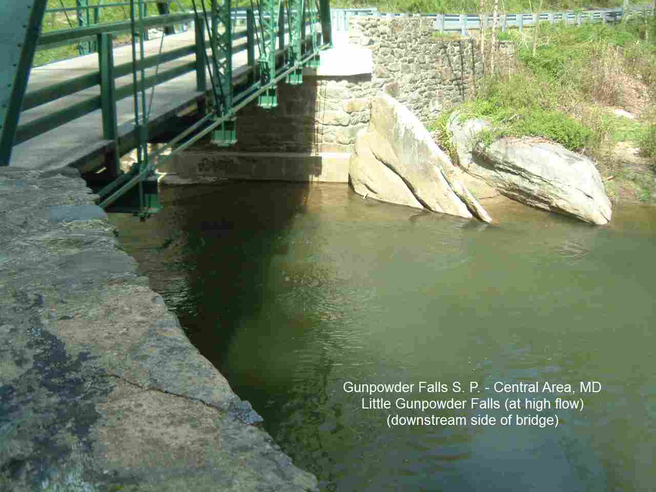
LITTLE GUNPOWDER FALLS [LITT]: Swimming place/water play place at rapids in Little Gunpowder Falls. PHOTO , PHOTO . There are A LOT of no parking signs on the road (and hardly any safe parking even if there weren't the signs), so you may have to walk a ways after you park (legally) to get to the bridge and swimming hole. There are strong currents here at some places so avoid these. From the Baltimore Beltway, take RT 1 (Belair Road) north about 7 miles from the Beltway to Kingsville. In Kingsville, follow Jerusalem Road as it bears to the right. Take an immediate right onto Bradshaw Road and continue for almost one mile. Turn left onto Franklinville Road (continue straight onto Vinegar Hill Rd). In about a mile you will cross a bridge over Little Gunpowder Falls River. (If you find yourself driving parallel to the river, you missed Vinegar Hill Rd). This is the swimming hole. LAT, LON : lat=39.44730, lon= -76.38099(source: map) (accuracy: approximate) LINK TO GOOGLE MAP. Very confident. Verified 4/2011. Updated 4/2011.
|
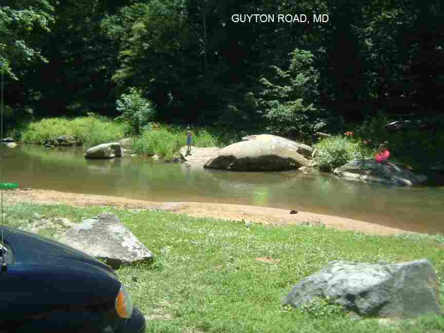
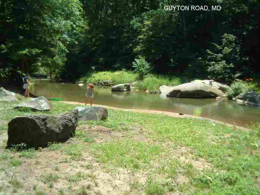
GUYTON ROAD [GUYT]: Nice little local swimming place in the Little Gunpowder River. Sandy beach, shallow near beach, deeper across the river with some large rocks there also. Relatively warm water. Nice for the whole family on a hot day. PHOTO , PHOTO To get here, continue north on RT 1 through Kingsville and across the Little Gunpowder River then turn left on Reckord Rd.. Follow Reckord Rd. across RT 147 then turn left on Guyton Rd. (before you get to Old Fallston Rd). Follow Guyton Rd., soon paralleling the Little Gunpowder River (becomes a dirt road), until you get to the river where you will see a parking area and beach on your left. LAT, LON lat=39.50268, lon=-76.42930(source: measured) (accuracy: exact) LINK TO GOOGLE MAP. Very confident. Verified 6/2010. Updated 6/2010. |
|
SWEET AIR [SWEE]: A detached portion of Gunpowder Falls S. P. Central Area, called the Sweet Air area, with a nice 2-4 mile hike along the Little Gunpowder with (maybe) some swimming and/or shallow water-play places along the hike (not sure). To get here: Continue north on RT 1 past Reckord Rd (see Guyton above) to Lynchs Corner then turn northwest (left) on Rt 152. Take RT 152 about 6 miles RT 165. Turn left heading south on 165 (Baldwin Mill Road). In a very short distance, turn right onto Greene Road, then right onto Moores Road, and left onto Dalton Bevard Road. Park at the large, signed parking area near the end of this road. Numerous trails leave from this parking area, making return loops. See the large trail maps in the kiosk. Go to the one with white blazes, which eventually parallels the creek. The (possible) swimming places are in the Little Gunpowder along this trail. Not certain. PARK AT: LAT, LON: lat=39.53610, lon=-76.5050(source: measured) (accuracy: approximate) LINK TO GOOGLE MAP. Pretty confident. Partially verified 6/2010. Updated 6/2010.
|
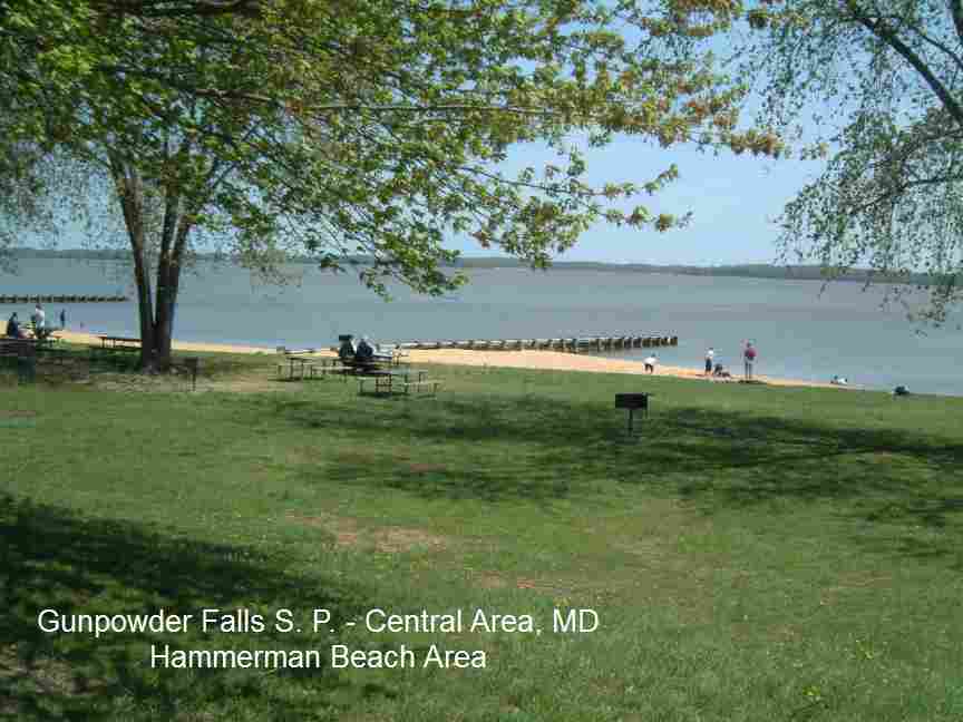
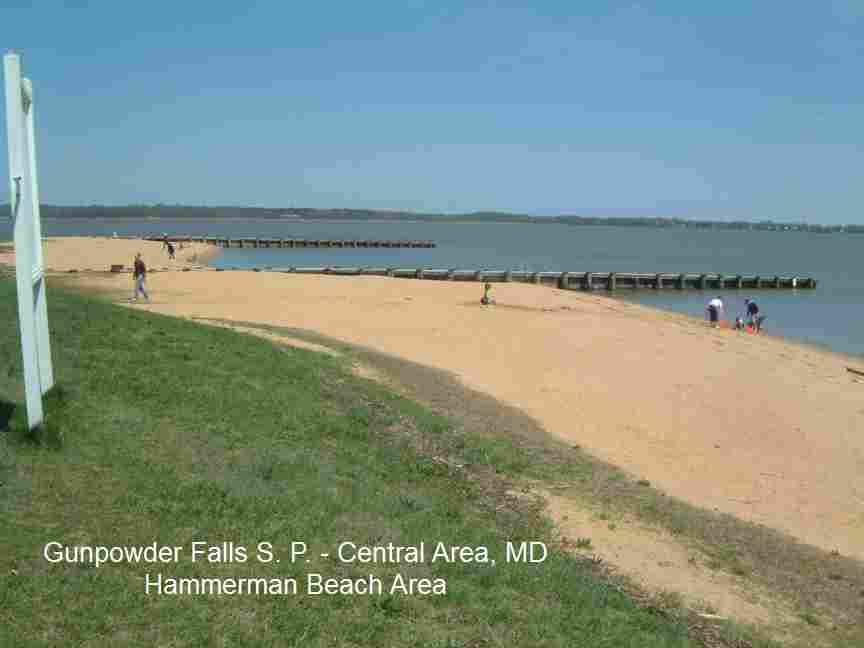
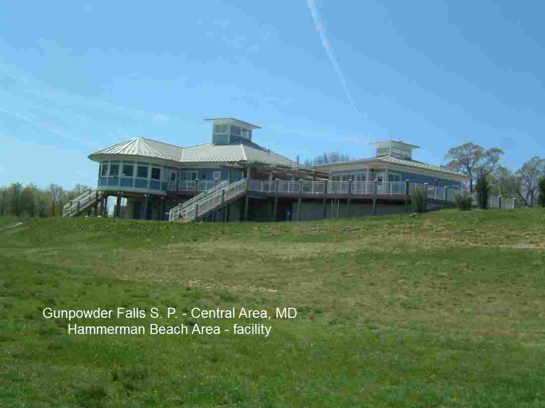
HAMMERMAN BEACH [HAMM]: The Hammerman Area offers 1,500 feet of beach and swimming area at Cunninghill Cove (where Gunpowder Falls empties into the Chesapeake Bay). WEB SITE . The swimming area is supervised by lifeguards from Memorial Day to Labor Day. Fee to enter. LINK TO AN ARTICLE ABOUT THIS PLACE. Swimming is permitted at your own risk when lifeguards are not on duty. PHOTO , PHOTO , PHOTO OF FACILITY .Four picnic shelters are available for rental. The area also has a food concession, picnic tables and grills, playground equipment and a windsurfing beach. Ultimate Watersports rents kayaks, wind surfboards and catamarans at the beach. Hammerman is open year-round, except Christmas and Thanksgiving. To get here: From I-95 take exit 67A then RT 43 east (White Marsh Boulevard). Follow RT 43 to RT 40 east. After turning onto RT 40, turn right at the first light onto Ebenezer Road and follow it for 4.5 miles. The park entrance will be on your left. Very confident. Verified 4/2011. Updated 4/2011. LAT, LON: lat=39.3644, lon=-76.3407(source: map) (accuracy: approximate) LINK TO GOOGLE MAP. Very confident. Verified 4/2011. Updated 4/2011. |
|
JONES ROAD AREA [JONE]: Swimming hole with rope swings and rocks to jump from. Can be lots of trash - take an extra bag with you and carry some out, please. LINK TO AN ARTICLE ABOUT THIS PLACE. Two swimming places are one with rocks to jump right under the train trestle and another a short walk beyond the rocks. Both spots have rope swings but the farther one is less crowded and no train noise. To get here, from I-695 (Baltimore Beltway) north of Baltimore take RT 40 north. Just after you cross the Gunpowder River, take a left onto Jones Rd. (is easy to miss, if you get to Joppa Farm Rd., you've gone too far.) Right after turning onto Jones Rd., park at the lot on the left (dont park anywhere else). After you park, follow a trail down to the water (There are multiple trails and branches, stay on the most prominent trail). LAT, LON: lat=39.41319, lon=-76.38751(source: measured) (accuracy: approximate) LINK TO GOOGLE MAP. Pretty confident. Verified by Alex Camlin/Baltimore Examiner. Updated 2/2011.
|
|---|
|
CONFIDENCE | Varies - see above |
|---|
|
VERIFIED | Varies - see above |
|---|
|
DATE UPDATED | 2/2011 |
|---|
This swimming hole listing is by
www.swimmingholes.org
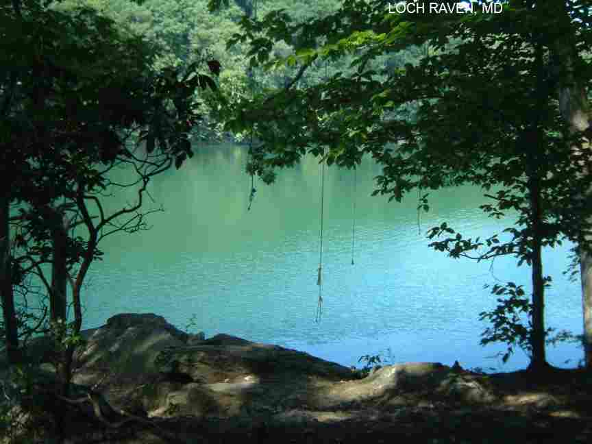
LOCH RAVEN
(LOCH)
| |
|---|
| TOWNS |
BALTIMORE, TIMONIUM |
|---|
| LAT, LON (DRIVE) | lat=39.43815 lon=-76.55299(source: map) (accuracy:exact)
LINK TO GOOGLE MAP |
|---|
| LAT, LON (SWIM) | lat=39.44213, lon=-76.54887(source: map) (accuracy:approximate)
LINK TO GOOGLE MAP |
|---|
| STATE | MD |
|---|
| WATER | Loch Raven Reservoir |
|---|
| TYPE | Lake |
|---|
| DESCRIPTION | Small corner of large lake (reservoir) with rope swing and rocks/cliffs to jump. PLEASE NOTE: SWIMMING IS NOT PERMITTED HERE - the rules state� Bathing, wading, swimming and water skiing are prohibited." |
|---|
| AREAS | Unknown |
|---|
| SANCTION | Unofficial |
|---|
| FEE | No |
|---|
| FACILITIES | none |
|---|
| ACTIVITIES | Swimming, Rope swing, Jumping |
|---|
| PHONE | none |
|---|
| CAMPING | None at site |
|---|
| BATHING SUITS | Optional |
|---|
|
DIRECTIONS | From the north side of the Baltimore Beltway (I-695) take Exit 28, Providence Rd, north. Follow Providence Rd for about three miles to where it ends in a "T" with Lock Raven Rd. The trail you want leaves from the right far side of this T intersection. However, there is very little legal parking near here. If you go BACK up Providence Rd. (back the way you came) you will pass many "no parking" signs but, just as you leave the Loch Raven area and just as you enter a residential area (between Dogwood Hill Rd. and Roxleigh Rd.), you will see a wide shoulder on Providence Rd. that does not have "no parking" signs and often many cars parked here. Park here and walk along the path that follows Providence Rd. back down to the T intersection and then take the trail mentioned above. Follow that trail at first uphill (keep left at a major fork where there is a small tree stump with a hole in it) then downhill for a total of about 0.5 miles until you get to the water where you will see large rocks ands several rope swings. PLEASE NOTE: SWIMMING IS NOT PERMITTED HERE - the rules state� Bathing, wading, swimming and water skiing are prohibited."
|
|---|
| CONFIDENCE | Very confident |
|---|
| VERIFIED | Yes, 6/2010 |
|---|
| LAST UPDATE | 6/2010 |
|---|
This swimming hole listing is by
www.swimmingholes.org
MEADOWSIDE
(MEAD)
| |
|---|
| TOWNS |
BALTIMORE, ELLICOTT CITY, SYKESVILLE |
|---|
| LAT, LON | lat=39.11075, lon=-77.10603(source: DeLorme) (accuracy:approximate)
LINK TO GOOGLE MAP |
|---|
| STATE | MD |
|---|
| WATER | North Branch Rock Creek |
|---|
| TYPE | Creek |
|---|
| DESCRIPTION |
Small place for a cool dip in suburban creek just before it empties into Lake Bernard Frank. Unsure of cleanliness of water due to suburban location - be cautious, do not submerge your head here.
CAUTION: As of the summer of 2019,
many swimming holes in Montgomery County Maryland have detected
elevated levels of Microcystin.
Montgomery County Swimming Hazard to learn more.
|
|---|
| AREAS | Rock Creek Stream Valley Park |
|---|
| SANCTION | Unofficial |
|---|
| FEE | No |
|---|
| FACILITIES | none |
|---|
| ACTIVITIES | Wading, Swimming |
|---|
| PHONE | none |
|---|
| CAMPING | None at site |
|---|
| BATHING SUITS | Customary |
|---|
|
DIRECTIONS | From Washington DC, go north from the Beltway (I-495) on either Connecticut or Georgia Avenues (Connecticut eventually merges into Georgia Avenue, which is aka RT 97). 3 miles north of the Beltway, turn left on Norbeck Road (it's a major lighted intersection, aka Rt 28). Almost immediately, turn right on Muncaster Mill Road (aka Rt 115). In a little over a mile, you will cross over the north branch of Rock Creek, then turn left to the Meadowside Nature Center (5100 Meadowside Lane). Follow a trail that drops down to the stream valley from the rear, left side of the Nature Center as you face it from the parking
lot. It will bring you down to the north branch of Rock Creek. You will find a small swimming hole above where the creek empties into Lake Bernard Frank. It isn't much, but it's very close to DC. |
|---|
| CONFIDENCE | Very confident |
|---|
| VERIFIED | By another |
|---|
| LAST UPDATE | 1/21/2005 |
|---|
This swimming hole listing is by
www.swimmingholes.org
PATAPSCO VALLEY S. P. AREA
[2 PLACES]
(PATA)
| |
|---|
| TOWNS |
BALTIMORE, ELLICOTT CITY, SYKESVILLE, HENRYTON |
|---|
| STATE | MD |
|---|
| WATER | South Branch Patapsco River |
|---|
| TYPE | River |
|---|
| DESCRIPTION | River with some deep spots. PATAPSCO VALLEY S. P.. CAUTION: THERE WAS A JUMPER WHO DROWNED HERE IN 2003, PLEASE DO NOT JUMP OR SWIM HERE IF THERE IS ANY QUESTION OF SAFETY. I CANNOT VERIFY THE SAFETY OF THIS PLACE. YOU ARE RESPONSIBLE FOR YOUR OWN SAFETY. |
|---|
| AREAS | Patapsco Valley State Park |
|---|
| SANCTION | Unofficial |
|---|
| FEE | No |
|---|
| FACILITIES | none |
|---|
| ACTIVITIES | Swimming, rope swing, fishing |
|---|
| PHONE | none |
|---|
| CAMPING | Nearby at Patapsco River S. P. |
|---|
| BATHING SUITS | Customary. Spots are very near road. |
|---|
| DIRECTIONS | Take I-70 west of Baltimore to Exit 80. Take RT 32 north, then:
SYKESVILLE [SYKE]: River with some deep spots. To get here from I-70 west of Baltimore, take Exit 80 then RT 32 north about 3.4 miles then turn right onto River Rd.. You will see a park entrance sign and several pull-offs on the left side over the next mile, some have better swimming than others. One has a good sized rock with a large pool behind it. LAT, LON: lat=39.35861, lon=-76.96256(source: map) (accuracy:approximate) LINK TO GOOGLE MAP. Pretty confident. Verified by W. Brunner. Updated 2/2013.
HENRYTON [HENR]: River with deep swimming hole and rope swing. YOUTUBE , YOUTUBE . To get here from RT 32 and River Rd. (above) continue north on RT 32 a short way then turn right on Raincliffe Road, turn right when Raincliffe ends then the next left onto Arrington Road, right where Arrington ends, left on Arrington again, and right on Henryton Road. Follow Henryton Road down the hill to where it ends at the river. Cross the train tracks to the swimming hole with rope swing. LAT, LON: lat=39.35151, lon=-76.91359(source: map) (accuracy:approximate) LINK TO GOOGLE MAP. Pretty confident. Not verified Updated 2/2013. |
|---|
| CONFIDENCE | Pretty confident |
| VERIFIED | Varies - see above |
|---|
| LAST UPDATE | 2/2013 |
|---|
This swimming hole listing is by
www.swimmingholes.org
POTOMAC S. F. AREA
[6 PLACES]
(POTO)
| |
|---|
|
TOWNS | OAKLAND, GORMAN, KEARNEY |
|---|
|
STATE | MD |
|---|
|
WATER | Potomac River & tributaries |
|---|
|
TYPE | River |
|---|
|
DESCRIPTION | Swimming holes in Potomac River and tributaries. CAUTION: HOLES IN POTOMAC WILL BE VERY DANGEROUS IN HIGH FLOWS. For details, see "DIRECTIONS" below. See also nearby in West Virginia: MOUNT STORM AREA |
|---|
|
AREAS | Potomac S. F. |
|---|
|
SANCTION | Unofficial |
|---|
|
FEE | No |
|---|
| FACILITIES |
Unknown |
|---|
|
ACTIVITIES |
Swimming, |
|---|
|
PHONE | (301)334-2038 (Garrett/Potomac S.F.) |
|---|
|
CAMPING | There are semi-developed camping places in the State Forest. Also, north of Oakland are Deep Creek Lake S.P. and Swallow Falls S.P. both of which have camping as well as swimming. (See Swallow Falls swimming hole info below).
|
|---|
|
BATHING SUITS | Unknown |
|---|
|
DIRECTIONS | From Oakland (in far Western MD, Garrett County) take RT 135 then
RT 560 south (set odometer at this intersection). Then:
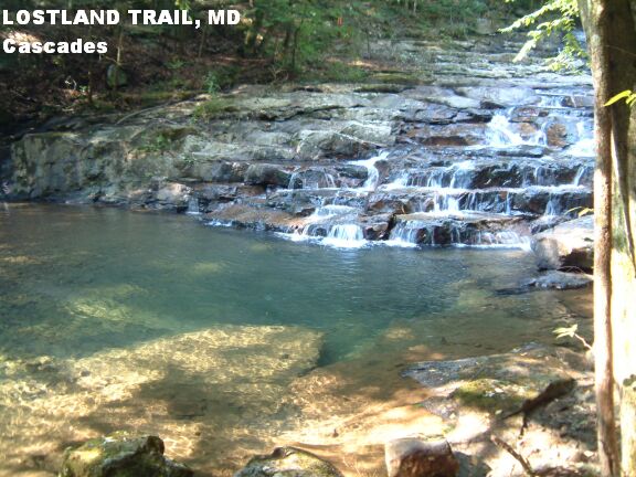
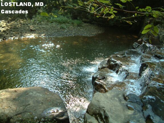
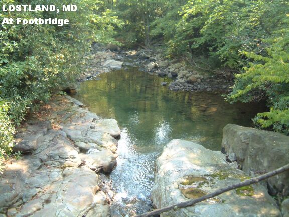
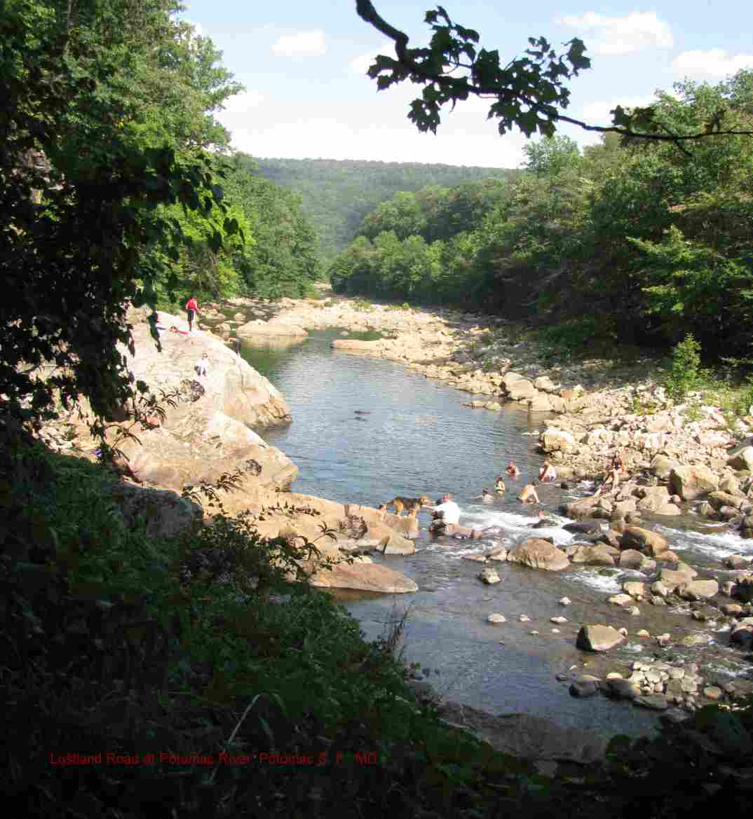
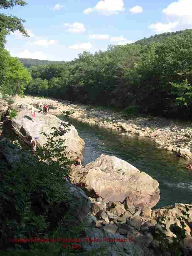
LOSTLAND [LOST]: From the intersection of RT 135 and RT 560, go about 2.2 mi on RT 560 then turn left on Bethlehem Rd.. (From here, there will be signs to the State Forest). Go about 3.4 miles then turn left onto Combination Rd.. Go about .6 miles then turn left on Potomac Camp Rd.. Go about 1 mile then turn right onto Lostland Rd.. Pass park headquarters (where you can ask for maps and information) onto a dirt road (Lostland Rd) that goes down to the Potomac (set odometer). There are three swimming holes down this road:
First: In 2.1 miles down this road, park in the large parking place on the right. There is a trail with a sign that says "Cascades" here. Follow the trail a very short way to the cascades and pool. This is an outstandingly beautiful cascade and swimming hole below - would be a great movie location! PHOTO 1 , PHOTO 2 Enjoy! LAT, LON FOR CASCADES: lat=39.36559, lon=-79.24501(source: Measured) (accuracy: exact) LINK TO GOOGLE MAP.
Second: At 2.9 miles down this road, there is a small parking area on the right. Take the wide trail leaves this area in the upstream direction (it has a trail register). When you get to the footbridge, there is a large swimming hole below. PHOTO . LAT, LON FOR FOOTBRIDGE: lat=39.36140, lon=-79.23375(source: Measured) (accuracy: exact) LINK TO GOOGLE MAP.
Third: At the end of the road, park and walk a short way to the Potomac River. There is a big swimming hole about 200-300 yards downstream in the Potomac. PHOTO , PHOTO There are several rocks to jump off of and 2 pools that are 10-15 feet deep. It is a great and refreshing hole. An interesting big cave formation above it on a hillside.
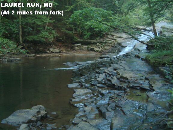
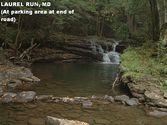
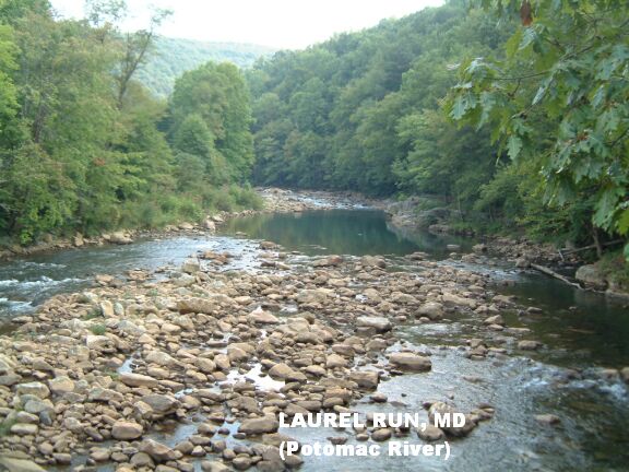
LAUREL RUN [LAUR]: From the intersection of RT 135 and RT 560, go about 5.1 mi south on RT 560 then turn left on White Church -Steyer Rd. (at big sign for Potomac State Forest). Go about 1.2 miles then turn left on Audley Riley Rd. (very small sign for state forest). Go about 1.2 miles more (road turns to dirt) into the State Forest to the fork where Laurel Run Rd. goes left and Wallman Rd. goes right. Keep left onto Laurel Run Rd (set odometer here) which runs along Laurel Run and has camping areas along the road (tables but no drinking water or toilets). Laurel Run has a number of nice swimming holes.
The first is at about 2 miles from the fork - a nice hole with a long cascade into it PHOTO . There is a small parking turn out here on the right. There are a series of cascades you can walk to just downstream from here ending with another nice swimming hole just behind campsite #29 at: lat=39.34462, lon=-79.26657(source: Measured ) (accuracy: exact) LINK TO GOOGLE MAP.
Another is just at the parking area at the end of the road PHOTO .
LAT, LON AT PARKING AREA: lat=39.34140, lon=-79.2600(source: Measured ) (accuracy: exact) LINK TO GOOGLE MAP.
The last is: from the parking area, cross the run and walk the short trail to the Potomac River. LAT,LON: lat=39.34187, lon=-79.25752(source: Map ) (accuracy: general area) LINK TO GOOGLE MAP. There is a big swimming hole on the Potomac, just upstream of Laurel Run. PHOTO .
|
|---|
|
CONFIDENCE | Very confident |
|---|
|
VERIFIED | Yes, 5/2007 |
|---|
|
DATE UPDATED | 5/2007 |
|---|
This swimming hole listing is by
www.swimmingholes.org
ROCKS S. P. AREA
[3 PLACES]
(ROCK)
| |
|---|
|
TOWNS | EDGEWOOD, BEL AIR, JARRETTSVILLE |
|---|
|
LAT, LON | lat=39.64097, lon=-76.41592(source: DeLorme) (accuracy:general area)
LINK TO GOOGLE MAP |
|---|
|
STATE | MD |
|---|
|
WATER | Deer Creek |
|---|
|
TYPE | Creek |
|---|
|
DESCRIPTION | Beautiful linear park along Deer Creek - lots of family fun
picnicking, swimming and tubing! Can tube and swim here on 3 1/2 miles of Deer Creek. Bring
your own tubes (includes class 3 rapid that most people walk around rather than tube
through.) Several swimming holes, 10' - 12' deep, reachable by tube also from parking lots at
picnic areas along creek. See "DIRECTIONS" below for details. |
|---|
|
AREAS | Rocks State Park |
|---|
|
SANCTION | Official |
|---|
|
FEE | Park free on road or $2.00 per person in picnic area lots.
|
|---|
|
FACILITIES |
Picnic tables, toilets with changing room |
|---|
|
ACTIVITIES |
Swimming, Tubing |
|---|
|
PHONE | (410)557-7994 |
|---|
|
CAMPING | Not at site, camp nearby at Susquehanna State
Park |
|---|
|
BATHING SUITS | Required |
|---|
|
DIRECTIONS | From Baltimore, take I-95 north to exit 77 then RT 24 northwest through Bel Air to Rocks then turn west (left) on St. Clair Bridge Rd. which parallels Deer Creek. The swimming areas are:
WILSON CREEK PICNIC AREA [WILS]: Follow the signs to the Wilson Creek Picnic Area. LAT, LON : lat=39.64097, lon= -76.41592 (source: map) (accuracy: approximate) LINK TO GOOGLE MAP. The best swimming hole is to your right as you enter the parking area.
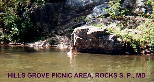
HILLS GROVE PICNIC AREA [HILL]: Follow the signs to the Hills Grove Picnic Area. LAT, LON : lat=39.6397, lon= -76.42498 (source: map) (accuracy: approximate) LINK TO GOOGLE MAP. There is an excellent swimming hole here, with a nice gravel beach. Very clean water. HILLS GROVE PICNIC AREA PHOTO
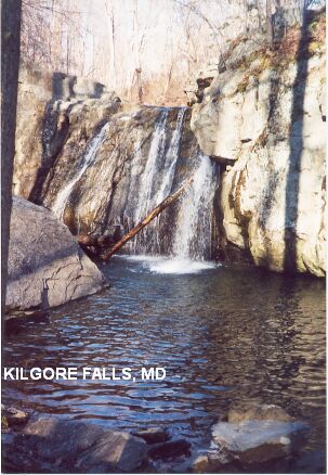
KILGORE FALLS [KILG]: Kilgore Falls is a well little known (and very scenic) wading/swimming place in a separate part of Rocks S. P. on Falling Branch Creek. From the sign on RT 24 to the above picnic areas, go about 4 miles more up RT 24 (through the traffic circle) then go left on St. Mary's Rd.. Go about .5 miles then take a right on Falling Branch Rd.. This is a dirt road. Take it about .6 miles where it takes a sharp right turn and ends in a parking area (very little parking available.). Park and take the trail about .3 miles to the falls. This looks like a nice place for kids and there is a gradual entry to the water for play. KILGORE FALLS PHOTO. LAT, LON : lat=39.6918, lon= -76.4272 (source: measured) (accuracy: exact) LINK TO GOOGLE MAP. |
|---|
|
CONFIDENCE | Very confident |
|---|
|
VERIFIED | Yes, all places |
|---|
|
DATE UPDATED | 7/2018 |
|---|
This swimming hole listing is by
www.swimmingholes.org
SILVER SPRING KIDS FOUNTAIN
(SKID)
| |
|---|
|
TOWNS | WASHINGTON DC, SILVER SPRING MD |
|---|
| LAT, LON | lat=38.99585,lon=-77.02658(source: map) (accuracy:approximate)
LINK TO GOOGLE MAP |
|---|
|
STATE | MD |
|---|
|
WATER | Fountain |
|---|
|
TYPE | Fountain |
|---|
|
DESCRIPTION | Water-play fountain for kids in center of a lively shopping, restaurant and entertainment complex in downtown Silver Spring MD (a northern suburb of Washington DC). Cool relief on a hot summer day. WEB INFO .
|
|---|
|
AREAS | Downtown Silver Spring |
|---|
|
SANCTION | Official |
|---|
|
FEE | None |
|---|
|
FACILITIES |
All facilities nearby in shopping area |
|---|
|
ACTIVITIES |
Water play |
|---|
|
PHONE | None |
|---|
|
CAMPING | None |
|---|
|
BATHING SUITS | Required |
|---|
|
DIRECTIONS | Via AUTO: From Washington DC beltway, I-495, on the north side, take exit 30 onto RT 29 south (Colesville Rd.). Turn east (left) on Georgia Ave then left again on Ellsworth Dr.. Find a place to park and walk to the plaza and fountain. Via METRORAIL - Take the Red line to the Silver Spring METRO station. Walk generally northeast about 4 blocks to the plaza.
|
|---|
|
CONFIDENCE | Highly confident |
|---|
|
VERIFIED | Ye |
|---|
|
DATE UPDATED | 9/2014 |
|---|
This swimming hole listing is by
www.swimmingholes.org
SWALLOW FALLS S. P.
[4 PLACES}
(SWAL)
| |
|---|
|
TOWNS | OAKLAND |
|---|
|
LAT, LON | lat=39.49667, lon=-79.42556(source: Topozone) (accuracy:general area)
LINK TO GOOGLE MAP |
|---|
|
STATE | MD |
|---|
|
WATER | Youghiogheny River/Muddy Creek/Tolliver Run |
|---|
|
TYPE | Waterfalls/River/Creek |
|---|
|
DESCRIPTION | There are two waterfalls in Swallow Creek State Park;
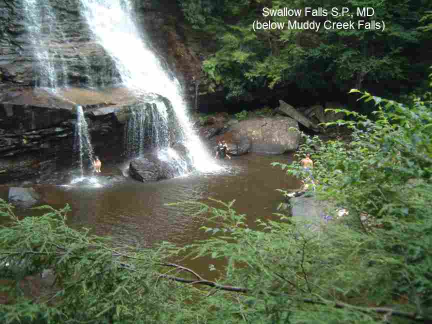
Swallow Falls (on the Yough. River) and Muddy Creek Falls (on Muddy Creek). There are several very fine swimming holes just below each falls and more in the creek and river downstream of each falls.
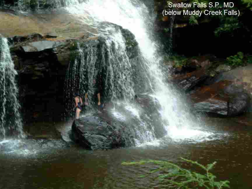
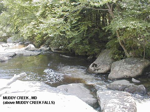
MUDDY CREEK FALLS [MUDD]: The best swimming hole is at the bottom of Muddy Creek Falls. PHOTO BELOW MUDDY CREEK FALLS , PHOTO BELOW MUDDY CREEK FALLS. Don't climb or swim in the immediate area ABOVE Muddy Creek Falls - people have fallen to their death here. However, if you go farther back upstream, above Muddy Creek Falls, there is a safe and nice place to swim. PHOTO ABOVE MUDDY CREEK FALLS. LAT, LON : lat=39.50113, lon= -79.41854(source: map) (accuracy: approximate) LINK TO GOOGLE MAP.
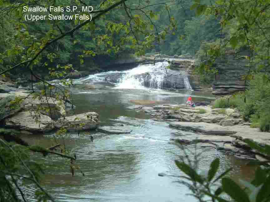
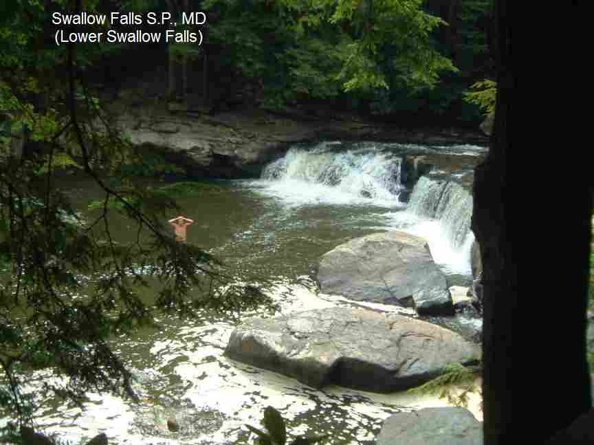
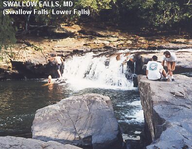
SWALLOW FALLS [SWAL]: The largest falls, Upper Swallow Falls, is pretty spectacular but not the best place to swim PHOTO UPPER SWALLOW FALLS. The best swimming place is in Swallow Falls, the Lower Falls section PHOTO LOWER SWALLOW FALLS , PHOTO LOWER SWALLOW FALLS.. LAT, LON : lat=39.49589, lon= -79.41725 (source: map) (accuracy: approximate) LINK TO GOOGLE MAP.
Also, in this park, if you follow the Tolliver Run trail a short way up from the river (very near Swallow Falls) you come to a gorge carved from rock and a small 5 foot waterfall with a pool and sandy beach (and very cold water).
Overall, Swallow Falls S. P. is a very good place for family fun in the water. Camp and swim and spend a few days exploring. |
|---|
|
AREAS | Swallow Falls S. P.
|
|---|
| SANCTION | Unofficial |
|---|
|
FEE | Yes |
|---|
|
FACILITIES |
Toilet, Picnic tables |
|---|
|
ACTIVITIES |
Swimming, jumping, rope swing |
|---|
|
PHONE | (301)334-9180 |
|---|
|
CAMPING | Very nice wooded camping is available at Swallow Falls S.P. and
nearby at Deep Creek Lake S.P. |
|---|
|
BATHING SUITS | Customary |
|---|
|
DIRECTIONS | From Oakland (in Western MD, Garrett County) follow
county road RT 20 northwest about 9 miles to park. |
|---|
|
CONFIDENCE | Very confident |
|---|
|
VERIFIED | Yes, 8/2011 |
|---|
|
DATE UPDATED | 8/2011 |
|---|
HOME
|
