See a SLIDESHOW of swimming hole photos in this state.
This swimming hole listing is by
www.swimmingholes.org
CASCADE CREEK
(CAPI)
|
|
TOWNS | DURANGO, CASCADE VILLAGE |
|---|
|
LAT, LON (trailhead) | lat=37.66113, lon=-107.8136(source: DeLorme) (accuracy:approximate)
LINK TO GOOGLE MAP |
|---|
|
STATE | CO |
|---|
|
WATER | Cascade Creek |
|---|
|
TYPE | River/Falls |
|---|
|
DESCRIPTION | Hike about 4 miles round trip in a beautiful slot canyon to waterfalls and swimming places. |
|---|
|
AREA | San Juan N. F. |
|---|
|
SANCTION | Unofficial |
|---|
|
FEE | None |
|---|
|
FACILITIES |
Unknown |
|---|
|
ACTIVITIES |
Swimming |
|---|
|
PHONE | Unknown |
|---|
|
CAMPING | Camping on RT 550 just south of here |
|---|
|
BATHING SUITS | Unknown |
|---|
|
DIRECTIONS | From Durango, take RT 550 north about 30 miles (Past Cascade Village) to the hairpin turn to the right. Just after the hairpin turn, turn north (left) on a rocky road and drive about 20 minutes then park at the weather tower (if you have a 4 WD vehicle, you may be able to drive further.) Hike on the road, pass some cabins, for about 1 mile, then see a locked gate and a trail to the right along the creek. If you walk another 2 miles, you will come to the first waterfall. You can keep hiking past here (keep to the right at Engine Creek Trail) and get to several other waterfalls in quick succession.
|
|---|
|
CONFIDENCE | Pretty confident |
|---|
|
VERIFIED | No |
|---|
|
DATE UPDATED | 1/2014 |
|---|
|
|---|
This swimming hole listing is by
www.swimmingholes.org
CURECANTI AREA
[3 PLACES]
(CURA)
|
|
TOWNS | MONTROSE, CIMMERON, GUNNISON |
|---|
|
STATE | CO |
|---|
|
WATER | Gunnison River/Blue Mesa Reservoir |
|---|
|
TYPE | Lake |
|---|
|
DESCRIPTION | In the Curecanti N.R.A. is the Blue Mesa Reservoir on the Gunnison River. The banks of the reservoir are generally very rocky and steep but there are a few easily accessed swimming places. The water is cool and there are "no wake" rules at the below swimming places. For details, see DIRECTIONS below. |
|---|
|
AREA | Curecanti N.R.A. |
|---|
|
SANCTION | Unofficial |
|---|
|
FEE | None |
|---|
|
FACILITIES |
None |
|---|
|
ACTIVITIES |
Swimming |
|---|
|
PHONE | None |
|---|
|
CAMPING | Several campgrounds along RT 50. |
|---|
|
BATHING SUITS | Unknown |
|---|
|
DIRECTIONS | From Montrose, go east on RT 50 about 50 miles to the Curecanti N.R.A. Visitors Center. Then:
BAY OF CHICKENS [BAYC]: Swimming place in the Blue Mesa Reservoir about 1.2 miles WEST of the visitor center on RT 50. LAT, LON : lat=38.47711 lon=-107.17661(source: map) (accuracy:approximate) LINK TO GOOGLE MAP . Pretty confident. Not verified. Updated 1/2014.
OLD HWY 50 BEACH [OLDH]: Swimming place in the Blue Mesa Reservoir adjacent to the Elk Creek Campground right by the visitor center. LAT, LON : lat=38.466 lon=-107.167(source: map) (accuracy:approximate) LINK TO GOOGLE MAP. Pretty confident. Not verified. Updated 1/2014.
DRY CREEK [DRYC]: Swimming place in the Blue Mesa Reservoir at the Dry Creek picnic area about 1 miles EAST of the visitor center on RT 50. LAT, LON : lat=38.47335 lon=-107.1464 (source: map) (accuracy:approximate) LINK TO GOOGLE MAP . Pretty confident. Not verified. Updated 1/2014.
|
|---|
|
CONFIDENCE | Pretty confident |
|---|
|
VERIFIED | No |
|---|
|
DATE UPDATED | 1/2014 |
|---|
|
|---|
This swimming hole listing is by
www.swimmingholes.org
DEVILS PUNCHBOWL
(DEVP)
|
|
TOWNS | GLENWOOD SPRINGS, ASPEN |
|---|
| LAT, LON | lat=39.119156, lon=-106.7086462(source: usgs web site) (accuracy: approximate)
LINK TO GOOGLE MAP |
|---|
|
STATE | CO |
|---|
|
WATER | Roaring Fork River |
|---|
|
TYPE | Falls fed pool |
|---|
|
DESCRIPTION | Very cold, very deep bowl with lots of high-jumping opportunities - be very careful of currents, especially in spring. |
|---|
|
AREA | White River NF |
|---|
|
SANCTION | Official |
|---|
|
FEE | No |
|---|
|
FACILITIES |
No facilities |
|---|
|
ACTIVITIES |
Swimming, jumping |
|---|
|
PHONE | None
|
|---|
|
CAMPING | No camping at site, there are several NF campgrounds on RT 82 east of here. |
|---|
|
BATHING SUITS | Probably optional |
|---|
|
DIRECTIONS | From Aspen take RT 82 east (toward Independence Pass) for about 7 miles. Look for a parking pull-out and maybe some cars on the south side of the road. The punchbowl is right there by the road.
|
|---|
|
CONFIDENCE | Pretty confident |
|---|
|
VERIFIED | No |
|---|
|
DATE UPDATED | 2/2010 |
|---|
|
|---|
This swimming hole listing is by
www.swimmingholes.org
DOMINGUEZ CANYON
(DOMI)
|
|
TOWNS | GRAND JUNCTION |
|---|
| LAT, LON (parking area) | lat=38.84937, lon=-108.3720(source: map) (accuracy: approximate)
LINK TO GOOGLE MAP |
|---|
|
STATE | CO |
|---|
|
WATER | Gunnison River, Little Dominguez Creek |
|---|
|
TYPE | River/Creek |
|---|
|
DESCRIPTION | Multiple swimming holes along an 6-8 mile minimum (round trip) hike in the Dominguez Canyon of the Gunnison River and joining the canyons of Little Dominguez Creek and Big Dominguez Creek (see map, topo version). |
|---|
|
AREA | Uncomphagre NF (?) |
|---|
|
SANCTION | Unofficial |
|---|
|
FEE | No |
|---|
|
FACILITIES |
Unknown |
|---|
|
ACTIVITIES |
Swimming |
|---|
|
PHONE | None
|
|---|
|
CAMPING | Undeveloped camping in the canyon, mostly used by rafters, get your site early in the day. Much developed camping in national forests west and east of here. |
|---|
|
BATHING SUITS | Probably optional in areas away from rafters on the Gunnison River. |
|---|
|
DIRECTIONS | There are 3-4 access points to Dominguez Canyon. The one described here is from the Bridgeport trailhead. From Grand Junction take RT 50 south about 20 miles then turn west (right) on Bridgeport Rd. and go 3 miles to the parking area at the Bridgeport Trailhead (coordinates above are for parking area). Bridgeport road is a maintained gravel road that is passable by any vehicle. When you get to the parking area it gets a little confusing because there is a trailhead on each end. The trailhead on the north end of the parking area is for the river rats and the trailhead on the south end is for hikers (take this trail). From here, follow the hiking directions on the below web sites. The first good swimming hole you come to is said to be at the mouth of Little Dominguez Creek, maybe 2-3 miles from the trailhead. There are more swimming holes within another mile up the canyon.
HIKE DESCRIPTION , HIKE DESCRIPTION ,
HIKE DESCRIPTION.
|
|---|
|
CONFIDENCE | Very confident |
|---|
|
VERIFIED | No |
|---|
|
DATE UPDATED | 1/2013 |
|---|
|
|---|
This swimming hole listing is by
www.swimmingholes.org
DURANGO-ANIMAS
(DURA)
|
|
TOWNS | DURANGO |
|---|
| LAT, LON | lat=37.28902, lon=-107.87446(source: map) (accuracy: approximate)
LINK TO GOOGLE MAP |
|---|
|
STATE | CO |
|---|
|
WATER | Animas River |
|---|
|
TYPE | River |
|---|
|
DESCRIPTION | Right in Durango there are swimming places in the Animas River. This one is behind the high school on the Animas River trail. |
|---|
|
AREA | None |
|---|
|
SANCTION | Unofficial |
|---|
|
FEE | No |
|---|
|
FACILITIES |
Unknown |
|---|
|
ACTIVITIES |
Swimming |
|---|
|
PHONE | None
|
|---|
|
CAMPING | None at site. |
|---|
|
BATHING SUITS | Customary |
|---|
|
DIRECTIONS | The Animas River Trail is accessible in the area of W 22nd St. east of Main St (RT 550) on Alamo Dr. The swimming hole is behind the nearby High School off this trail. Don't know about where to park.
|
|---|
|
CONFIDENCE | Pretty confident |
|---|
|
VERIFIED | No |
|---|
|
DATE UPDATED | 1/2014 |
|---|
|
|---|
This swimming hole listing is by
www.swimmingholes.org
GLENWOOD HOT SPRINGS
(GLEH)
|
|
TOWNS | DENVER, BRECKINRIDGE, GRAND JUNCTION, GLENWOOD SPRINGS |
|---|
| LAT, LON | lat=39.55013, lon=-107.32462(source: map) (accuracy:approximate)
LINK TO GOOGLE MAP |
|---|
|
STATE | CO |
|---|
|
WATER | Hot Springs |
|---|
|
TYPE | Hot Springs |
|---|
|
DESCRIPTION | Commercial resort with hot springs feeding huge concrete pool. Lodge, spa and all facilities. Day use of springs allowed for a fee. For all information, see their WEB SITE. |
|---|
|
AREA | Glenwood Hot Springs |
|---|
|
SANCTION | Official |
|---|
|
FEE | Yes - see web site |
|---|
|
FACILITIES |
All facilities |
|---|
|
ACTIVITIES |
Hot Soaking, swimming |
|---|
|
PHONE | 800-537-7946 |
|---|
|
CAMPING | No camping at site - lodge facilities. |
|---|
|
BATHING SUITS | Required |
|---|
|
DIRECTIONS | From Denver, take I-70 west 160 miles to exit #116 at Glenwood Springs. From Exit ll6, head toward the traffic light and before you arrive at the intersection make a right on North River Street and you'll see the sign and parking for the Hot Springs Pool on the left. Continue around the complex and you'll see the lodge. Address: 401 N River St. Glenwood Springs, CO 81601
|
|---|
|
CONFIDENCE | Very confident |
|---|
|
VERIFIED | Yes |
|---|
|
DATE UPDATED | 2/2013 |
|---|
|
|---|
This swimming hole listing is by
www.swimmingholes.org
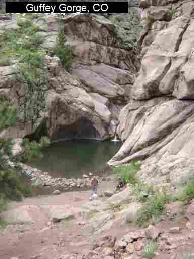
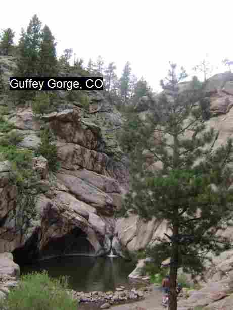
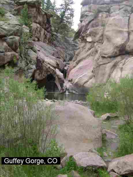
GUFFEY GORGE
(GUFF)
|
|
TOWNS | COLORADO SPRINGS, FLORISSANT, GUFFEY |
|---|
| LAT, LON | lat=38.7716, lon=-105.3364(source: measured by another) (accuracy: approximate)
LINK TO GOOGLE MAP |
|---|
|
STATE | CO |
|---|
|
WATER | Fourmile Creek |
|---|
|
TYPE | Creek |
|---|
|
DESCRIPTION | Spring-fed swimming hole bordered by large granite boulders and 100-feet high cliffs. Also called "Paradise Cove".
From
mid-May to mid-September, there is a $6 per vehicle day-use fee. There are
regulations in place: no alcohol, no
overnight camping, no amplified music, no target shooting, no glass, pets
must be on a leash, and parking in designated areas only. Visitors are only
allowed to use the area between dawn and dusk.
|
|---|
|
AREA | Unknown |
|---|
|
SANCTION | Official |
|---|
|
FEE | $6.00 |
|---|
|
FACILITIES |
None |
|---|
|
ACTIVITIES |
Swimming |
|---|
|
PHONE | None |
|---|
|
CAMPING | No overnight camping allowed at site. |
|---|
|
BATHING SUITS | Customary |
|---|
|
DIRECTIONS | From Colorado Springs, follow RT 24 to the town of Florissant (34.5 miles). From Florissant, follow Teller County Road 1 south for
about 9.2 miles, until a Y fork, and bear right, into County Road 11. Follow County Road 11 for 4.1 miles, until a T intersection, and make a right turn at the intersection, into County Road 112. Follow County Road 112 for 2.7 miles, and where the road crests on top of a hill, park in the gravel lot on the
left. On foot, cross the road and follow a foot trail in direction North for about 0.4 miles to the swimming hole. |
|---|
|
CONFIDENCE | Pretty confident |
|---|
|
VERIFIED | By another |
|---|
|
DATE UPDATED | 1/2013 |
|---|
|
|---|
This swimming hole listing is by
www.swimmingholes.org
ISLAND ACRES
(ISLA)
|
|
TOWNS | DENVER, GRAND JUNCTION |
|---|
| LAT, LON | lat=39.168457, lon=-108.30102(source: map) (accuracy:approximate)
LINK TO GOOGLE MAP |
|---|
|
STATE | CO |
|---|
|
WATER | Colorado River |
|---|
|
TYPE | Small Lake |
|---|
|
DESCRIPTION | Colorado River S. P. - Island Acres Section - Swimming place with sandy beach at state park. RESERVE AMERICA WEB SITE. |
|---|
|
AREA | Colorado River S. P. - Island Acres Section |
|---|
|
SANCTION | Official |
|---|
|
FEE | Yes |
|---|
|
FACILITIES |
All facilities |
|---|
|
ACTIVITIES |
Swimming |
|---|
|
PHONE | (970)464-0548 |
|---|
|
CAMPING | Camping at site. |
|---|
|
BATHING SUITS | Required |
|---|
|
DIRECTIONS | From Grand Junction, take I-70 east about 20 miles - watch for signs to Colorado River S. P. - Island Acres Section.
|
|---|
|
CONFIDENCE | Very confident |
|---|
|
VERIFIED | No |
|---|
|
DATE UPDATED | 2/2013 |
|---|
|
|---|
This swimming hole listing is by
www.swimmingholes.org
MEDANO CREEK
(MEDA)
|
|
TOWNS | PUEBLO, WALSENBURG, ALAMOSA |
|---|
|
LAT, LON | lat=37.73190, lon=-105.5140 (source: map) (accuracy:approximate)
LINK TO GOOGLE MAP |
|---|
|
STATE | CO |
|---|
|
WATER | Medano Creek |
|---|
|
TYPE | Creek |
|---|
|
DESCRIPTION | Popular water play place at Great Sand Dunes N. P.. Water depth varies a lot, best in spring and early summer, usually dry in the rest of the year. See the WEB SITE for lots of info on this. |
|---|
|
AREA | Great Sand Dunes N. P. |
|---|
|
SANCTION | Unofficial |
|---|
|
FEE | Unknown |
|---|
|
FACILITIES |
Unknown |
|---|
|
ACTIVITIES |
Swimming, tubing, skim boarding, water play |
|---|
|
PHONE | None |
|---|
|
CAMPING | Camping nearby in N.P.
|
|---|
|
BATHING SUITS | Required |
|---|
|
DIRECTIONS | Great Sand Dunes National Park is located 35 miles northeast of Alamosa, reached by RT 160 and RT 150 from the south, or from RT 17 and County Lane 6 from the west. The river access is right by the dunes parking area.
|
|---|
|
CONFIDENCE | Very confident |
|---|
|
VERIFIED | No |
|---|
|
DATE UPDATED | 1/2014 |
|---|
|
|---|
This swimming hole listing is by
www.swimmingholes.org
QUEENS CANYON PUNCHBOWLS
(QUEE)
|
|
TOWNS | COLORADO SPRINGS |
|---|
| LAT, LON | lat=38.89319, lon=-104.88689(source: DeLorme) (accuracy:general area)
LINK TO GOOGLE MAP |
|---|
|
STATE | CO |
|---|
|
WATER | Camp Creek |
|---|
|
TYPE | Creek |
|---|
|
DESCRIPTION | A series of small holes in a creek in a scenic desert canyon. One is deep enough to swim (usually) the others more for water play. Nice, easy 2 mile round trip hike too. LINK TO INFO. |
|---|
|
AREA | Queens Canyon |
|---|
|
SANCTION | Unofficial |
|---|
|
FEE | No |
|---|
|
FACILITIES |
Unknown |
|---|
|
ACTIVITIES |
Swimming, Water Play |
|---|
|
PHONE | Unknown |
|---|
|
CAMPING | Unknown |
|---|
|
BATHING SUITS | Required |
|---|
|
DIRECTIONS | From I-25 in Colorado Springs take the Garden of the Gods exit and go west 2 miles then turn south (left) on 30th St. Go about .5 mile to the entrance to the Navigators & Glen Eyrie Conference Center. Go towards the conference center through a gate. Access is free to the public but you must sign a liability waiver to hike Queen's Canyon. The trailhead is at the castle parking lot.
It is about a 2 mile roundtrip hike. The trail follows Camp Creek and is soon in Queens Canyon. In about .75 miles you will come to a small falls called Dawson Falls and the trail seems to end. To get to the punch bowls, follow a trail that goes up steeply to the right then follows the creek again and is soon at the punchbowls.
|
|---|
|
CONFIDENCE | Pretty confident |
|---|
|
VERIFIED | No |
|---|
|
DATE UPDATED | 11/29/2007 |
|---|
|
|---|
This swimming hole listing is by
www.swimmingholes.org
STEAMBOAT SPRINGS AREA
[2 PLACES]
(STEA)
|
|
TOWNS | DENVER, GEORGETOWN, STEAMBOAT SPRINGS |
|---|
|
STATE | CO |
|---|
|
WATER | Varies - see below |
|---|
|
TYPE | Varies - see below |
|---|
|
DESCRIPTION | Swimming holes and commercial hot springs northwest of Denver in a popular ski area town. See DIRECTIONS below for details.
|
|---|
|
AREA | Routt National Forest |
|---|
|
SANCTION | Varies - see below |
|---|
|
FEE | Varies - see below |
|---|
|
FACILITIES |
Varies - see below |
|---|
|
ACTIVITIES |
Varies - see below |
|---|
|
PHONE | Varies - see below |
|---|
|
CAMPING | Varies - see below |
|---|
|
BATHING SUITS | Varies - see below |
|---|
|
DIRECTIONS | From Denver, take I-70 west to Georgetown then RT 40 northwest through Hot Sulphur Springs to Steamboat Springs. Then:
YAMPA RIVER CORE TRAIL [YAMP]: Beginning at Rotary Park in Steamboat, this seven mile, cottonwood -lined scenic multi-use trail follows the meandering Yampa River. There are several swimming holes in the Yampa River along here - the best spots are said to be between miles 2 and 4 (uncertain which direction on trail). LAT, LON : lat=40.48981, lon=-106.84258(source: DeLorme) (accuracy:general area) LINK TO GOOGLE MAP. Pretty uncertain. Not verified. Updated 11/28/2007
STRAWBERRY PARK HOT SPRINGS [STRA]:A luxurious, commercial hot springs with lodging and everything else. For all information, see STRAWBERRY PARK HOT SPRINGS. LAT, LON : lat=40.52833, lon=-106.76575(source: DeLorme) (accuracy:approximate) LINK TO GOOGLE MAP. Uncertain. Not verified. Updated 12/1/2005
|
|---|
|
CONFIDENCE | Varies -see above |
|---|
|
VERIFIED | No |
|---|
|
DATE UPDATED | 11/27/2007 |
|---|
|
|---|
This swimming hole listing is by
www.swimmingholes.org
TABEGUACHE CREEK
(TABE)
| |
TOWNS | GRAND JUNCTION, NATURITA |
|---|
| LAT, LON | lat=38.35800, lon=-108.62911(source: DeLorme) (accuracy:exact)
LINK TO GOOGLE MAP |
|---|
|
STATE | CO |
|---|
|
WATER | Tabeguache Creek |
|---|
|
TYPE | Creek |
|---|
|
DESCRIPTION | Swimming hole in creek in very remote area of Southwestern Colorado. The directions given here are how one would get there by road but we do not know how good or passable the roads are. You can also backpack to here and information about this it at the BLM Web Site . |
|---|
|
AREA | BLM land |
|---|
|
SANCTION | Unofficial |
|---|
|
FEE | None |
|---|
|
FACILITIES |
Unknown |
|---|
|
ACTIVITIES |
Swimming |
|---|
|
PHONE | None |
|---|
|
CAMPING | Unknown |
|---|
|
BATHING SUITS | Optional (very remote) |
|---|
|
DIRECTIONS | From I-70 at Grand Junction, go south on RT 50 through Delta and Montrose to Ridgeway. In Ridgeway, go southwest on RT 62 to Placerville then northwest on RT 145 to Naturita. In Naturita, go north on RT 97 to Nucla. In Nucla, find 27 RD and work your way north to Z Rd then west to Z26 Rd. Follow Z26 Rd west and north (may become a rough, unpaved road) until you come to a bridge over Tabeguache Creek. The swimming hole is said to be just upstream of this bridge. (If you find this one, please tell us). |
|---|
|
CONFIDENCE | Pretty uncertain (of route) |
|---|
|
VERIFIED | No |
|---|
|
DATE UPDATED | 1/4/2006 |
|---|
|
|---|
This swimming hole listing is by
www.swimmingholes.org
VALLEY VIEW HOT SPRINGS
(VALL)
|
|
TOWNS | SALIDA, VILLA GROVE |
|---|
| LAT, LON | lat=38.191, lon=-105.816(source: web site) (accuracy:exact)
LINK TO GOOGLE MAP |
|---|
|
STATE | CO |
|---|
|
WATER | Valley View Hot Springs |
|---|
|
TYPE | Natural hot springs and hot springs creek |
|---|
|
DESCRIPTION | Part of the 2200 acre "Orient Land Trust", Valley View is a large commercial hot springs with both natural and concrete pools (10 hot pools total). There are overnight facilities including cabins, camping and the Oak House dorm with bunks. VVHS is kid friendly and fully clothing optional. Admission and camping fees apply and reservations are needed in the summer. A variety of educational activities on site include hikes to the bat cave, historic mining town tours, hydro-electric tours (entire facility is off the grid), astronomy, geology, etc. Beautiful views down the valley. (Used to be a membership facility but no longer requires membership.) WEB INFO . DIRECTIONS AND MAP .
|
|---|
|
AREA | Orient Land Trust |
|---|
|
SANCTION | Official |
|---|
|
FEE | Yes, see web site |
|---|
|
FACILITIES |
All facilities |
|---|
|
ACTIVITIES |
Hot Tubbing |
|---|
|
PHONE | 719-256-4315
|
|---|
|
CAMPING | Camping at site - fee |
|---|
|
BATHING SUITS | Optional (nudist, mostly) |
|---|
|
DIRECTIONS | From Pueblo, go west on RT 50 to Poncha Springs then south on RT 285 to Villa Grove. Continue on RT 285 for 4.5 miles then (at the intersection of RT 285 and RT 17) turn east (left) on Saguache County Road GG and go 7 miles on this gravel road to Valley View Hot Springs. |
|---|
|
CONFIDENCE | Very confident |
|---|
|
VERIFIED | Yes |
|---|
|
DATE UPDATED | 7/2012 |
|---|
|
|---|
HOME
|
