
ALBERTA, ONTARIO, NEWFOUNDLAND AND LABRADOR, |
|---|
|
|
|
|
|
Click here to see the home page and learn about swimming holes in other states
ALBERTA
NEWFOUNDLAND AND LABRADOR
This swimming hole listing is by www.swimmingholes.org
|
| ||
|---|---|---|---|
| TOWNS | ST. JOHNS, LAMANCHE FALLS | ||
| LAT, LON | lat=47.16696, lon=-52.89548, (source: map) (accuracy: approximate) LINK TO GOOGLE MAP | ||
| PROVINCE | NL | ||
| WATER | Lamanche River/Falls | ||
| TYPE | Falls | ||
| DESCRIPTION | Beautiful swimming place at falls. It is an easy 1.4 KM hike each way. WEB SITE . | ||
| AREAS | Lamanche Provincial Park | ||
| SANCTION | Unofficial | ||
| FEE | Unknown | ||
| FACILITIES | Unknown | ||
| ACTIVITIES | Swimming | ||
| PHONE | unknown | ||
| CAMPING | At site. | ||
| BATHING SUITS | unknown | ||
| DIRECTIONS | Lamanche Provincial Park is south of St. Johns. From RT 1 take RT 31 east to RT 10 then south to the park. Then find the 1.4 km easy hike on a marked trail to Lamanche Falls. | ||
| CONFIDENCE | Pretty confident | ||
| VERIFIED | No | ||
| DATE UPDATED | 1/2011 |
This swimming hole listing is by www.swimmingholes.org
|
| ||
|---|---|---|---|
| TOWNS | GRAND FALLS-WINDSOR | ||
| LAT, LON | lat=48.94438, lon=-55.77930, (source: map) (accuracy: approximate) LINK TO GOOGLE MAP | ||
| PROVINCE | NL | ||
| WATER | Leech Brook | ||
| TYPE | Creek/falls | ||
| DESCRIPTION | Very popular swimming places with multiple falls. Good for families. "There's the landing, then the first falls, a spot above the second falls called the bathtub. That was the spot if you were one of the local expert divers. You'd scale the cliffs. The water is very deep there." | ||
| AREAS | unknown | ||
| SANCTION | unofficial | ||
| FEE | Unknown | ||
| FACILITIES | unknown | ||
| ACTIVITIES | Swimming, jumping | ||
| PHONE | none | ||
| CAMPING | none at site. | ||
| BATHING SUITS | Customary | ||
| DIRECTIONS | From Grand Falls-Windsor, go west on RT 1 about 6 miles. No better directions. | ||
| CONFIDENCE | Pretty confident | ||
| VERIFIED | No | ||
| DATE UPDATED | 1/2011 |
This swimming hole listing is by www.swimmingholes.org
|
| |
|---|---|---|
| TOWNS | BUCHANS | |
| LAT, LON | lat=48.82664, lon=-56.84326, (source: map) (accuracy: general area) LINK TO GOOGLE MAP | |
| PROVINCE | NL | |
| WATER | Buchans River | |
| TYPE | River/Falls | |
| DESCRIPTION | Long-time local swimming hole - beautiful swimming place at falls. Waterfall, high cliffs, very deep. It is an easy 10 minute hike each way. | |
| AREAS | Unknown | |
| SANCTION | Unofficial | |
| FEE | Unknown | |
| FACILITIES | Unknown | |
| ACTIVITIES | Swimming | |
| PHONE | unknown | |
| CAMPING | unknown. | |
| BATHING SUITS | unknown | |
| DIRECTIONS | Dont really know where this place is. It is near Buchans on the Buchans River. No better directions. | |
| CONFIDENCE | uncertain | |
| VERIFIED | No | |
| DATE UPDATED | 1/2011 |
This swimming hole listing is by www.swimmingholes.org
|
| |
|---|---|---|
| TOWNS | POINT LEAMINGTON | |
| LAT, LON | lat=49.32115, lon=-55.40216 , (source: map) (accuracy: general area) LINK TO GOOGLE MAP | |
| PROVINCE | NL | |
| WATER | Mill River ? | |
| TYPE | River/Falls | |
| DESCRIPTION | Well-marked Rowsell's Hill Nature Trail in Point Leamington is a steep 1.5 KM climb to a waterfalls and a beautiful swimming area in the forest. Steep with stairs in places, about 500 stairs! | |
| AREAS | Unknown | |
| SANCTION | Unofficial | |
| FEE | Unknown | |
| FACILITIES | Unknown | |
| ACTIVITIES | Swimming | |
| PHONE | unknown | |
| CAMPING | unknown. | |
| BATHING SUITS | unknown | |
| DIRECTIONS | Dont know exactly where this place is. The trail begins at the Information Center for Point Leamington on RT 350. No better directions. | |
| CONFIDENCE | uncertain | |
| VERIFIED | No | |
| DATE UPDATED | 1/2011 |
NEW BRUNSWICK
This swimming hole listing is by www.swimmingholes.org
|
| |
|---|---|---|
| TOWNS | MONCTON | |
| LAT, LON | lat=45.67704, lon=-65.01117, (source: map) (accuracy: general area) LINK TO GOOGLE MAP | |
| PROVINCE | NB | |
| WATER | Unknown | |
| TYPE | Falls | |
| DESCRIPTION | In Fundy National Park, hike Laverty Falls Trail to unspoiled falls with swimming at the bottom. Length and difficulty of hike is unknown. (There are also several opportunities to swim in large natural rocky swimming holes if you to continue on past Laverty Falls.) | |
| AREAS | Fundy National Park | |
| SANCTION | Unofficial | |
| FEE | Unknown | |
| FACILITIES | Unknown | |
| ACTIVITIES | Swimming | |
| PHONE | unknown | |
| CAMPING | unknown. | |
| BATHING SUITS | unknown | |
| DIRECTIONS | Fundy National Park is on the north shore of the Bay of Fundy, south of Moncton. Ask for information on the Laverty Falls Trail. | |
| CONFIDENCE | pretty confident | |
| VERIFIED | No | |
| DATE UPDATED | 1/2011 |
ONTARIO
This swimming hole listing is by www.swimmingholes.org
|
| |
|---|---|---|
| TOWNS | NIAGRA FALLS (canada), ST. CATHERINES | |
| LAT, LON | lat=43.11048, lon=-79.26906, (source: map) (accuracy: approximate) LINK TO GOOGLE MAP | |
| PROVINCE | ON | |
| WATER | unknown | |
| TYPE | River/Falls | |
| DESCRIPTION | Hike to waterfall where you can swim in the relatively warm water below the falls. | |
| AREAS | none | |
| SANCTION | Unofficial | |
| FEE | None | |
| FACILITIES | Unknown | |
| ACTIVITIES | Swimming | |
| PHONE | none | |
| CAMPING | none at site. | |
| BATHING SUITS | unknown | |
| DIRECTIONS | Dont know exactly where this place is. From St. Catherines (northwest of Niagara Falls, Canada) take RT 406 south then Decew Rd west. I think you access the river trail along this road somewhere. Take the trail that winds along beside the river (Bruce Trail?) to the falls. Swim at the falls. Don�t know how long this hike is. No better directions. | |
| CONFIDENCE | Uncertain | |
| VERIFIED | No | |
| DATE UPDATED | 1/2011 |
This swimming hole listing is by www.swimmingholes.org
|
| |
|---|---|---|
| TOWNS | NOELVILLE, WOLSELEY BAY | |
| LAT, LON | lat=46.10047, lon=-80.16454, (source: map) (accuracy: approximate) LINK TO GOOGLE MAP | |
| PROVINCE | ON | |
| WATER | unknown | |
| TYPE | River | |
| DESCRIPTION | Also known as "The Washing Machine" because of the whirlpool there. To get here requires a boat and a 6 mile (each way) trip over the water. Swim in rapids and whirlpool. Also scuba diving. Best time are first weeks of August for fewer bugs and warmer water. Boats can be rented at Wolseley Bay (46.10567,-80.26706) or you can launch your own. Ask locally for over-the-water directions. Also, the coordinates above should be pretty accurate. | |
| AREAS | unknown | |
| SANCTION | Unofficial | |
| FEE | None | |
| FACILITIES | Unknown | |
| ACTIVITIES | Swimming | |
| PHONE | none | |
| CAMPING | none at site. | |
| BATHING SUITS | unknown | |
| DIRECTIONS | From Ottawa, go nw on RT 17 about 275 miles to Hager then RT 535 south to Noelville then take RT 64 and then unknown roads (ask locally) east to Wolseley Bay (46.10567,-80.26706). Rent or launch boat here and get directions to Five Finger Rapids. Ask locally for over-the-water directions. Also, the coordinates above should be pretty accurate. | |
| CONFIDENCE | Pretty Confident | |
| VERIFIED | No | |
| DATE UPDATED | 1/2011 |
This swimming hole listing is by www.swimmingholes.org
|
| |
|---|---|---|
| TOWNS | LONDON, ST. MARYS | |
| LAT, LON | lat=43.25009, lon=-55.40216 , (source: map) (accuracy: general area) LINK TO GOOGLE MAP | |
| PROVINCE | ON | |
| WATER | Quarry | |
| TYPE | Quarry | |
| DESCRIPTION | Town-operated quarry swimming with lifeguards, entry fee (about $5.00). | |
| AREAS | none | |
| SANCTION | Official | |
| FEE | About $5.00 | |
| FACILITIES | Unknown | |
| ACTIVITIES | Swimming | |
| PHONE | 519-284-2340 ext. 623 | |
| CAMPING | none at site. | |
| BATHING SUITS | required | |
| DIRECTIONS | Dont know exactly where this place is. It is in St. Mary's which is north of London. Should not be too hard to find - ask locally. No better directions. | |
| CONFIDENCE | Very confident | |
| VERIFIED | No | |
| DATE UPDATED | 1/2011 |
NOVA SCOTIA
This swimming hole listing is by www.swimmingholes.org
|
| |
|---|---|---|
| TOWNS | HALIFAX, BROOKLYN | |
| LAT, LON | lat=45.01418, lon=-63.96187, (source: map) (accuracy: general area) LINK TO GOOGLE MAP | |
| PROVINCE | NS | |
| WATER | Meander River | |
| TYPE | River | |
| DESCRIPTION | Deep swimming hole in Meander River under iron girder bridge near (or in) Smiley's Provincial Park. | |
| AREAS | Smiley's Provincial Park | |
| SANCTION | Unofficial | |
| FEE | None | |
| FACILITIES | Unknown | |
| ACTIVITIES | Swimming, jumping | |
| PHONE | none | |
| CAMPING | At Smiley's Provincial Park. | |
| BATHING SUITS | unknown | |
| DIRECTIONS | Dont know exactly where this place is. Go to Smiley's Provincial Park (northwest of Halifax then east of Brooklyn). There is an iron girder bridge there and a deep swimming hole in the river below. Some people jump from the bridge. No better directions. | |
| CONFIDENCE | Uncertain | |
| VERIFIED | No | |
| DATE UPDATED | 1/2011 |
QUEBEC
This swimming hole listing is by www.swimmingholes.org
|
| |
|---|---|---|
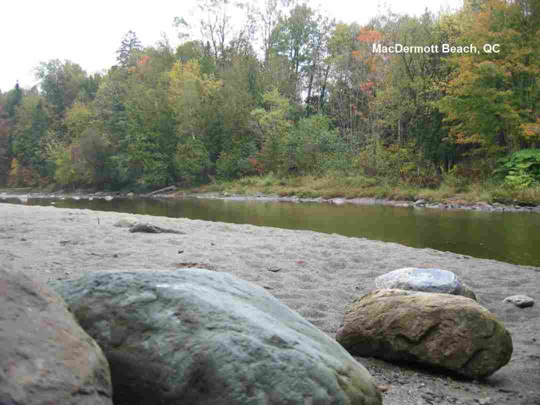
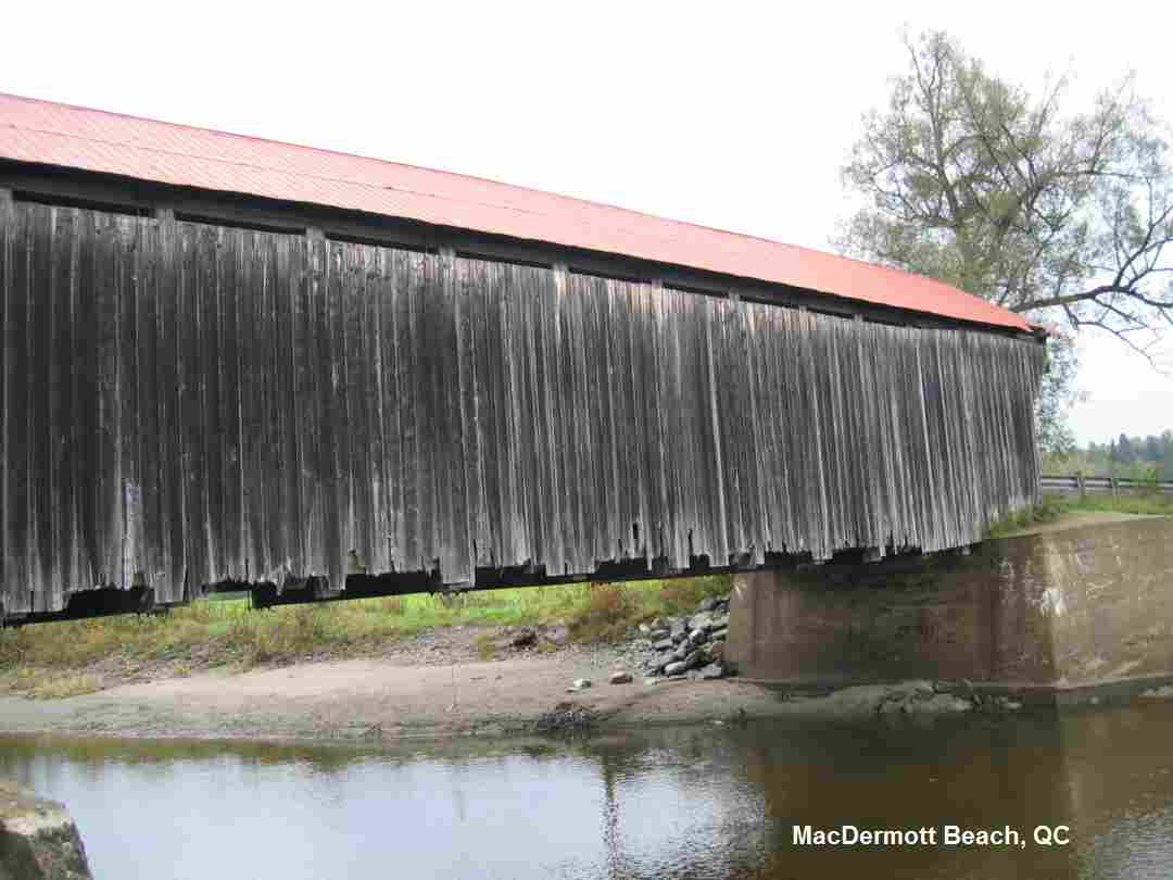
| TOWNS | SHERBROOKE, COOKSHIRE | |
| LAT, LON | lat=45.393146, lon=-71.555328, (source: map) (accuracy: approximate) LINK TO GOOGLE MAP | |
| PROVINCE | QC | |
| WATER | North Eaton River | |
| TYPE | River | |
| DESCRIPTION | This is a riverside beach and swimming hole beside the historic McDermott covered bridge built in 1886. On McDermott road on the North Eaton river in a remote part of Quebec's Eastern Townships. It is deep enough to swim underwater and there is often a short swinging rope. The beach is on the shallow side of the river, away from the main current. It is located on a quiet road in the middle of quiet farmland, a few hundred feet from the main highway. The Quebec government calls it a pastoral setting. | |
| AREAS | none | |
| SANCTION | Unofficial | |
| FEE | None | |
| FACILITIES | None | |
| ACTIVITIES | Swimming | |
| PHONE | None | |
| CAMPING | None at site. | |
| BATHING SUITS | Customary | |
| DIRECTIONS | From Sherbrooke, go east on RT 108 to Cookshire. From Cookshire, take RT 212 southeast about 5 miles then turn right on MacDermott Rd.. Swimming place is under bridge over river. | |
| CONFIDENCE | Pretty confident | |
| VERIFIED | No | |
| DATE UPDATED | 1/2011 |
HOME