
ARKANSAS SWIMMING HOLES
|
Click here to see the home page and learn about swimming holes in other states
|
TOWNS | LITTLE ROCK, BENTON | LAT, LON | lat=34.6056, lon=-92.6192(source: DeLorme)
(accuracy:exact) | LINK TO GOOGLE MAP
STATE | AR |
WATER | Saline River |
TYPE | River |
DESCRIPTION | Local swimming hole in the Saline River. No better description. |
AREAS | None |
SANCTION | Unofficial |
FEE | None |
FACILITIES |
None |
ACTIVITIES |
Swimming |
PHONE | None |
CAMPING | No camping at site. Camping west of here in Ouachita N. F., |
BATHING SUITS | Unknown |
DIRECTIONS | From Little Rock, take I-30 southwest about 15 miles to Benton area. Take RT 5 northwest a very short distance to where RT 5 crosses the Saline River. The swimming hole is here at the bridge. [See also nearby Saline River swimming holes at "Benton", "Jenkins Ferry",
"Farindale" and "Rye".] |
CONFIDENCE | Pretty confident |
VERIFIED | No |
DATE UPDATED | 9/11/2001 | |
|---|
This swimming hole listing is by www.swimmingholes.org
|
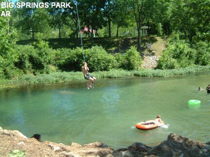
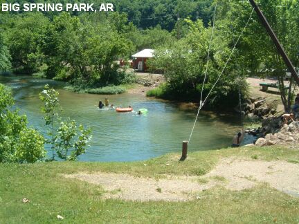
TOWNS | MOUNTAIN HOME | LAT, LON | lat=36.26577, lon=-92.54324(source: DeLorme)
(accuracy:exact) | LINK TO GOOGLE MAP
STATE | AR |
WATER | Big Springs (beside the White River) |
TYPE | Spring |
DESCRIPTION | Riverside city park with cool, spring-fed swimming hole with spectacular swinging rope. The spring arises right by the river and flows into the river. |
AREAS | None |
SANCTION | Official |
FEE | None |
FACILITIES |
Picnic tables, restroom |
ACTIVITIES |
Swimming, Swinging rope |
PHONE | Unknown |
CAMPING | None at site. Camp nearby at Bull Shoals S. P.. |
BATHING SUITS | Required |
DIRECTIONS | From Mountain Home in the north-central part of AR (due north of Little Rock, very near the Missouri border) take RT 62 southwest about 15 miles to Cotter. After you come across the bridge into town, follow the signs to the park (turn right), Big Springs Park, it is just to the right and below the bridge, in the middle of the town of Cotter. |
CONFIDENCE | Very confident |
VERIFIED | Yes, 5/05 |
DATE UPDATED | 5/27/2005 | |
|---|
This swimming hole listing is by www.swimmingholes.org
|
TOWNS | LITTLE ROCK, MORRILTON, JERUSALEM | LAT, LON (trailhead) | lat=35.4951, lon=-92.8745(source: DeLorme)
(accuracy:exact) | LINK TO GOOGLE MAP
STATE | AR |
WATER | Hurricane Creek |
TYPE | Creek/Falls |
DESCRIPTION | Hike 2+ miles each way (sometimes steep) into a creek hollow with low waterfalls and swimming holes. Can be pretty shallow in late summer. SNAKE ALERT: Watch out for snakes in the area. This is in the "Blue Hole Special Interest Area" of the Ozark National Forest. |
AREAS | Blue Hole Special Interest Area, Ozark National Forest |
SANCTION | Unofficial |
FEE | None |
FACILITIES |
Unknown |
ACTIVITIES |
Swimming, Jumping? |
PHONE | None |
CAMPING | Camp west of here at Bayou Bluff N. F. Campground on RT 27. |
BATHING SUITS | Maybe optional, very remote |
DIRECTIONS | From Little Rock, take I-40 west about 47 miles to Exit 107 at Morrilton. Then take RT 95 north about 12 miles, then turn west (left) on RT 124 and go about 12 miles (turning several times to stay on RT 124) through Jerusalem to Appleton. In Appleton, continue straight onto Evans Mtn. Rd. for about 6 miles then keep right at the fork onto FR 1301 (White Oak Mtn. Rd.) and go about .6 miles to the trailhead on the left and park. | Don't have much information about the hike. Looks like about 2.5 miles each way. Better you should get some local knowledge and a trail map if you can. These directions are very uncertain: The trail begins by hiking north along a ridge (for about 1.5 miles) then descending (to the east) to a creek (maybe bushwhacking down to meet the creek at about 35.51260,-92.8746) then hiking downstream (northwest) along this creek (for about .75 miles) where it meets a major creek that comes in from the east (right) (at 35.52094,-92.8806). This should be Hurricane Creek at Wolf Den Hollow. The falls and swimming hole are here or maybe a short way downstream on Hurricane Creek. Retrace your steps to return.
CONFIDENCE | Pretty confident |
VERIFIED | No |
DATE UPDATED | 2/2014 | |
|---|
This swimming hole listing is by www.swimmingholes.org
|
TOWNS |
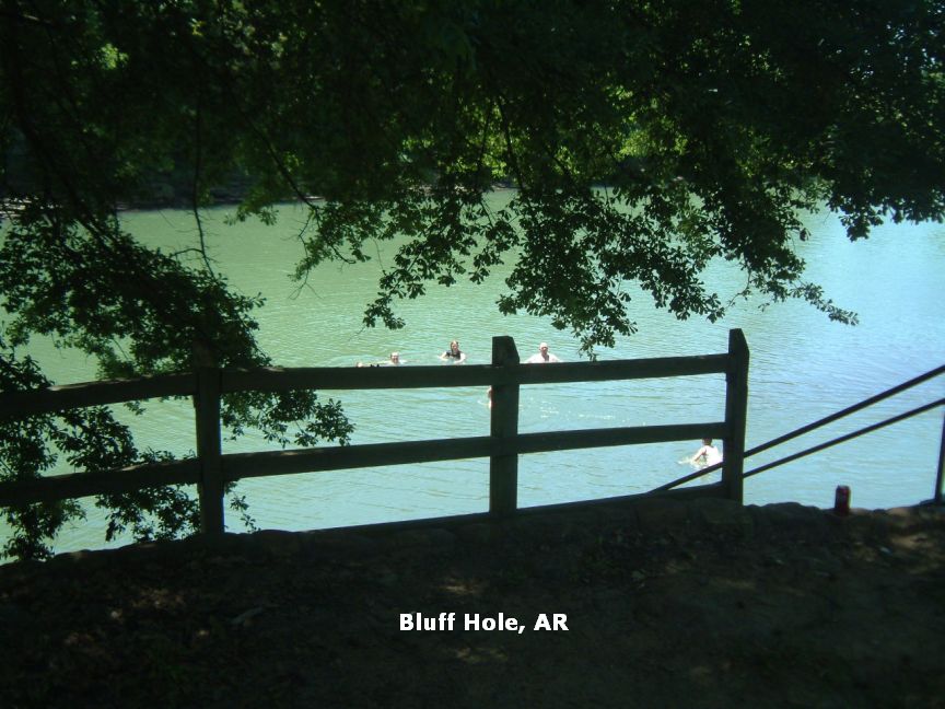
FORT SMITH, MULBERRY | LAT, LON | lat=35.5011, lon=-94.0344(source: Measured)
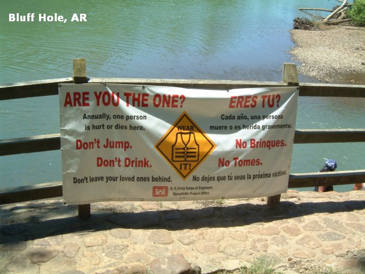
(accuracy:exact) | LINK TO GOOGLE MAP STATE | ARKANSAS | WATER | Mulberry River | TYPE |
River | DESCRIPTION |
NOTE- As of 6/11/11, this place was gated and locked, reputedly due to folks leaving trash here. It is very sad to loose nice, accessible family places like this due to peoples poor behavior. | Swimming hole in Corps of Engineers park (no lifeguard) just off I-40. High bluffs over swimming hole in the Mulberry River. Gently flowing downstream from the river's popular whitewater. Has picnic area and toilets. You have to swim across about 30-40 feet to climb the beautiful bluffs. There are different levels from which to jump off the bluff. CHECK DEPTH BEFORE JUMPING! To swim across, must be a swimmer, or, if not a swimmer, have a good life vest and a buddy. If you jump, be careful on the Bluff and where you land. AREAS | Corps of Engineers park | SANCTION | Semi-official, no lifeguards - locals go there a lot. | FEE | None | FACILITIES | Restroom and picnic tables. | ACTIVITIES | Swimming, jumping, picnicking | PHONE | none | CAMPING | No camping at site. Camping about 30 miles north up RT 23 at Turner's Bend (best place to rent canoes for floating), or Redding N.F. Campground a bit further on and to the east of Turners Bend. All pretty Ozarks area. Others along I-40. | BATHING SUITS |
Customary | DIRECTIONS | From Fort Smith, go 24 miles east on I-40. From I-40 take Exit 24 and go south on RT 215. Go to 4-way stop (Landmarks: Liberty Gas and Mulberry Market). This is the junction of RT 215 and RT 64. Turn east (left) on RT 64. Continue about .5 mile to signs for Bluff Hole Park. | CONFIDENCE | Very confident | VERIFIED | Yes, 5/09 | DATE UPDATED | 6/09 | |
|---|
This swimming hole listing is by www.swimmingholes.org
|
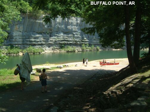
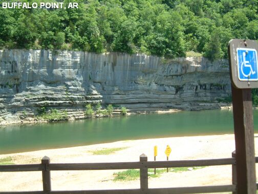
TOWNS | MOUNTAIN HOME, HARRISON, CANEY | LAT, LON | lat=36.07167, lon=-92.55525(source: DeLorme)
(accuracy:exact) | LINK TO GOOGLE MAP
STATE | AR |
WATER | Buffalo River |
TYPE | River |
DESCRIPTION | Very beautiful, primo swimming hole in the clean, clear waters of Buffalo River. Sandy beach, changing rooms, restrooms. BE CAREFUL OF CURRENTS IF THE RIVER IS HIGH. BUFFALO NATIONAL RIVER SITE. |
AREAS | Buffalo National River Area |
SANCTION | Official (no life guards) |
FEE | None |
FACILITIES |
Changing rooms, Restrooms, Picnic tables |
ACTIVITIES |
Swimming |
PHONE | Unknown |
CAMPING | Camping at site. There are also several camping places southwest of here in the Ozark N F. |
BATHING SUITS | Required |
DIRECTIONS | From Mountain Home in the north-central part of AR (due north of Little Rock, very near the Missouri border) take RT 62 southwest about 20 miles to Yellville (past Cotter and the "Big Spring Park" swimming hole). From Yellville take RT 14 about 15 miles south (past Caney) to signs for Buffalo Point. When in Buffalo Point park, follow the signs to the river access/boat launch. Swimming place is here in there river. | Downstream from Buffalo Point is Rush Landing, and many people canoe between the two. You can access Rush Landing by car also - go back north on RT 14 to near Caney and take RT 26 east and (hopefully) follow signs to Rush Landing. Rush Landing LAT, LON : lat=36.12452, lon=-92.54863(source: DeLorme) (accuracy:approximate) LINK TO GOOGLE MAP. There is camping at Rush Landing and may be swimming there also. Downstream of Rush Landing is a wilderness area - remote and not much visited. There are trails out of Rush Landing and you can hike to some river access points downstream of here or you can canoe (22 miles to the next access point, Buffalo City - an overnight canoe trip for sure). Anyway, there are some swimming holes in this stretch as well which are said to be clothing optional due to the remoteness of the area.
CONFIDENCE | Very confident |
VERIFIED | Yes, 5/05 |
DATE UPDATED | 12/24/2006 | |
|---|
This swimming hole listing is by www.swimmingholes.org
|
TOWNS | LITTLE ROCK, CONWAY, GREENBRIER |
STATE | AR |
WATER | Cadron Creek |
TYPE | Creek |
DESCRIPTION | Several swimming places at bridge crossings on Cadron Creek at State Fish and Game access points . Also canoe put-in places. Like most spots on this creek, they are rain dependent and can dry up into swampy conditions for a couple of months each year (July / August). The water level can be obtained at CADRON CREEK LEVEL. For details, see DIRECTIONS below. |
AREAS | AR Fish and Game access |
SANCTION | Unofficial |
FEE | None |
FACILITIES |
Unknown |
ACTIVITIES |
Swimming, Canoeing |
PHONE | Unknown |
CAMPING | Nearby at Wooly Hollow S. P. Also has swimming beach with lifeguards and maybe some unofficial places to swim in lake as well. |
BATHING SUITS | Customary |
DIRECTIONS | From Little Rock, take I-40 north to Conway then RT 65 north to Greenbrier. Then: | RT65 BRIDGE [RT65]: From Greenbrier, continue north on RT 65 for about 5 miles to where RT 65 crosses Cadron Creek. This from a visitor: "There is a paved game and fish access point on the north side (east exit). It's not as well defined a swimming hole as it is a boat launch, but there are some rope swings and jumping trees up river a tiny bit from this point." LAT, LON lat=35.299015, lon=-92.403603(source: map) (accuracy: approximate) LINK TO GOOGLE MAP RT123 BRIDGE [R285]: From Greenbrier, take Mountain Drive west about 1 mile then turn northwest (right) on Burkett Flat Rd and go about 5 miles then turn north (right) on RT 285 N. Take RT 285 N about 2.5 miles to where it crosses Cadron Creek. This from a visitor: "There is a parking lot on the south west side. From the parking lot there is a trail that goes under the bridge and into the woods up the creek. It crosses a low water stream and ends up at a well groomed swimming hole with jumping rocks and rope swings. The walk is short and quite easy to spot from traffic." LAT, LON lat=35.285564, lon=-92.472782(source: map) (accuracy: approximate) LINK TO GOOGLE MAP
CONFIDENCE | Pretty confident |
VERIFIED | No |
DATE UPDATED | 12/2012 | |
|---|
This swimming hole listing is by www.swimmingholes.org
|
TOWNS | HOT SPRINGS, CRYSTAL SPRINGS | LAT, LON | lat=34.51758, lon=-93.38194(source: DeLorme)
(accuracy:exact) | LINK TO GOOGLE MAP
STATE | AR |
WATER | Walnut Creek |
TYPE | Pond |
DESCRIPTION | Swim in a dammed pond on Walnut Creek. An old CCC recreation site, with bathhouse. |
AREAS | Ouachita N. F. |
SANCTION | Official |
FEE | Unknown |
FACILITIES |
Bathhouse, probably picnic tables, toilets |
ACTIVITIES |
Swimming |
PHONE | Unknown |
CAMPING | Camping at site. |
BATHING SUITS | Required |
DIRECTIONS | From Hot Springs, go west on RT 270. Charlton is 3 miles past the town of Crystal Springs on RT 270. [See also "Albert Pike" swimming place nearby] |
CONFIDENCE | Pretty confident |
VERIFIED | No |
DATE UPDATED | 9/11/2001 | |
|---|
This swimming hole listing is by www.swimmingholes.org
|
TOWNS | FORT SMITH, WALDRON, VANDERVOORT, WICKES | STATE | AR |
WATER | Cossatot River |
TYPE | River |
DESCRIPTION | Several traditional swimming holes in the Cossatot River S. P. & Natural Area. For details, see DIRECTIONS below. SNAKE ALERT AREA |
AREAS | Cossatot River S. P. & Natural Area |
SANCTION | Unofficial |
FEE | Unknown |
FACILITIES |
Picnic tables, toilets at Brushy Creek Access |
ACTIVITIES |
Swimming |
PHONE | Unknown |
CAMPING | There is camping and a lodge in the State Park. Also some campgrounds east of here in the Ouachita N. F. |
BATHING SUITS | Customary |
DIRECTIONS | From Fort Smith, take RT 71 south about 100 miles, through Waldron, through Y City (see "Mill Creek" swimming hole here) through Acorn, Mena and Cove to Vandervoort. Then: | BRUSHY CREEK RECREATION AREA [BRUS]: Traditional swimming hole with huge gravel beach at the Brushy Creek Recreation Area in the Cossatot River S. P. & Natural Area. Also day-use facilities including picnic sites, a nature trail, restrooms and river access. A walkway high above the river provides barrier-free access on the west side. LAT, LON : lat=34.3814, lon=-94.2339(source: DeLorme) (accuracy:approximate) LINK TO GOOGLE MAP. To get here from Vandervoort, go about 10 miles east on RT 246 to the bridge over the Cossatot River at the Brushy Creek Recreation Area . Just upstream from this bridge is the swimming hole. COSSATOT FALLS [COSF]: Primitive camp site with river access, clean water and small swimming holes among rocks and cliff to jump from. LAT, LON : lat=34.31244, lon=-94.22572(source: DeLorme) (accuracy:approximate) LINK TO GOOGLE MAP. To get here from the Vandervoort area, continue south on RT 71 about 4 miles and turn east (left) on RT 13. Go about 5 miles on RT 13 to sign that says river access. Keep left on the main road. Here is a falls and primitive camp site and swimming holes in river.
CONFIDENCE | Pretty confident |
VERIFIED | No |
DATE UPDATED | 12/22/2006 | |
|---|
This swimming hole listing is by www.swimmingholes.org
|
TOWNS | JONESBORO, PARAGOULD, WALNUT RIDGE, WALCOTT | LAT, LON | lat=36.04744, lon=-90.66539(source: DeLorme)
(accuracy:approximate) | LINK TO GOOGLE MAP
STATE | AR |
WATER | Unknown |
TYPE | Spring |
DESCRIPTION | Spring-fed swimming hole in state park. Also 2 swinging bridges. |
AREAS | Crowley's Ridge S. P. |
SANCTION | Unknown |
FEE | Unknown |
FACILITIES |
All facilities |
ACTIVITIES |
Swimming, Hiking |
PHONE | (501)573-6751 |
CAMPING | Camping at site. |
BATHING SUITS | Required |
DIRECTIONS | From Jonesboro (in the northeast corner of the state), take RT 141 north 15 miles to signs for the park. |
CONFIDENCE | Pretty confident |
VERIFIED | No |
DATE UPDATED | 9/11/2001 | |
|---|
This swimming hole listing is by www.swimmingholes.org
|
TOWNS | LITTLE ROCK, HEBER SPRINGS | LAT, LON | lat=35.52992, lon=-91.99801(source: map)
(accuracy:approximate) | LINK TO GOOGLE MAP
STATE | AR |
WATER | Greers Ferry Laken |
TYPE | Lake |
DESCRIPTION | High jumping/swimming place in Army Corps of Engineers Dam Site Rec Area at Greers Ferry Lake. (see videos above). |
AREAS | Dam Site Rec Area at Greers Ferry Lake |
SANCTION | Unofficial |
FEE | Unknown |
FACILITIES |
All facilities at rec area |
ACTIVITIES |
Jumping, Swimming |
PHONE | Unknown |
CAMPING | Camping at site. |
BATHING SUITS | Required |
DIRECTIONS | From Little Rock, take I-30 north then I-40 east then RT 167 north 16 miles then RT 5 north for 28 miles (past Heber Springs) into the Dam Site Rec. Area on Greers Ferry Lake. The jumping bluffs are in this rec area no further directions. |
CONFIDENCE | Pretty confident |
VERIFIED | No |
DATE UPDATED | 12/2012 | |
|---|
This swimming hole listing is by www.swimmingholes.org
|
TOWNS | EUREKA SPRINGS, BERRYVILLE, ROCKHOUSE |
STATE | AR |
WATER | Varies, see below |
TYPE | Varies, see below |
DESCRIPTION | Several swimming places near Eureka Springs in far northwest Arkansas on Beaver Lake and in King River. For details, see DIRECTIONS below. |
AREAS | None |
SANCTION | Unofficial |
FEE | Varies, see below |
FACILITIES |
Unknown |
ACTIVITIES |
Swimming, Jumping |
PHONE | Unknown |
CAMPING | There appears to be camping at several locations on the east side of Beaver Lake. |
BATHING SUITS | Some optional-see below |
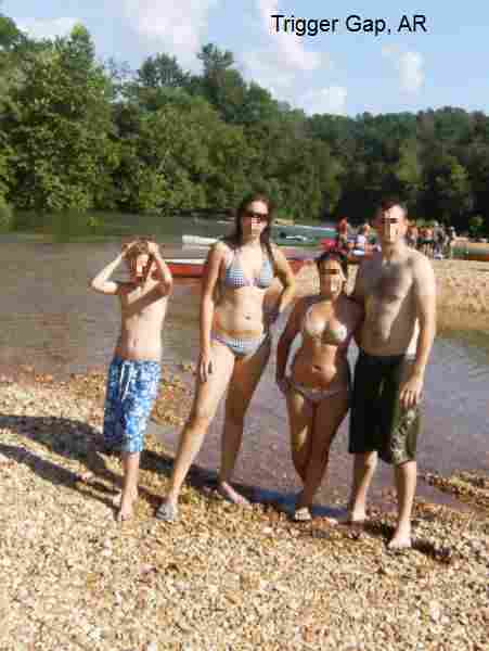
DIRECTIONS | Begin in Eureka Springs in far northwest Arkansas, then: | HOGSCALD HOLLOW [HOGS]: NOTE: The water here can be low, slow, murky and generally not appealing later in the summer. Best to get here in the springtime. From a local fan: This is a special spot just outside Eureka Springs. From Eureka Springs, take RT 23 south about 8 miles, turn west (right) on RT 108 for about .5 miles then turn south (left) at the first left on RT 148 and proceed down this dirt road quite a ways. After a few miles, you pass the Leap, which is a 50 foot drop into the lake. I've jumped it and it is easily the most insane thing I've done. Keep on driving to the end of the road...it dead ends right into the lake. Take the walking trails off to the left. There are several nice swimming spots along this trail, although the best is the farthest from the parking area, about a quarter mile hike. There are nice flat limestone bluffs that are about 10 feet out of the water...great for diving in. The best times to enjoy this spot are in the late spring and early fall, when the boat traffic is not as insane as it is in midsummer. People used to skinny dip here and word got out and over to the marina. Eventually all the boats meandered over to the cove, now known as Hogscald Hollow, to check the nekkid people out and watch people jump from the ridiculously high Leap I mentioned before. It's not quite as quiet and secluded as it used to be. Petitions are going around to close the cove to boats completely. This is a fantastic, Mark Twain-style place. LAT, LON lat=36.31222, lon=-93.81986(source: DeLorme) (accuracy: approximate) LINK TO GOOGLE MAP THE CLIFFS [CLIF]: From a local fan: Also on Beaver Lake. Take RT 62 west out of Eureka Springs to the SECOND RT 187 left turn, turn left. Go about 2 miles then right on RT 113, directly before Beaver Dam. The second left is a park area where there used to be camping sites available, but the Corps of Engineers shut it down because all the kids that hang out here at night drove the tourists away. It's still a great spot. Drive all the way to the rear of the park where there are still spots that appear to be camping sites. Park here and follow one of the many trails through the trees to the water's edge. You can either take the high trail to the top of the cliffs or the low route to the "beach" type lounging area. Even though there are signs warning against it, many people jump from the bluffs into the water 25 feet below. The water is relatively clean and stays cool all summer long. The cliffs skirt along the banks and the "beach" area is made of low limestone cliffs that are always cool to the touch and very nice to nap on. Another local favorite. LAT, LON lat=36.43072, lon=-93.85814(source: DeLorme) (accuracy: approximate) LINK TO GOOGLE MAP TRIGGER GAP [TRIG]: From a local fan: "This spot is on the Kings River, also outside Eureka Springs. Take RT 62 east to Berryville then RT 221 southwest several miles until you cross the over bridge over the Kings River. Then turn left on Star Lane (dirt road). Follow the signs to the Kings River Outfitters. Ernie who owns the place charges $3 to let people park at his canoe rental office during peak season. However, it's not to difficult to find another spot elsewhere to park. (An old bridge used to run across at this point of the river) The water gurgles about the old foundation where the bridge once was which creates some mild current. I would advise supervision of small children here. However, the bank is very safe and the water is cool and clear year round." PHOTO , PHOTO LAT, LON lat=36.30833, lon=-93.66250(source: DeLorme) (accuracy: approximate) LINK TO GOOGLE MAP
CONFIDENCE | Pretty confident |
VERIFIED | No |
DATE UPDATED | 2/2011 | |
|---|
This swimming hole listing is by www.swimmingholes.org
|
TOWNS | LITTLE ROCK, BENTON, SHERIDAN, FORDYCE | LAT, LON | lat=34.11557, lon=-92.40606(source: DeLorme) (accuracy:exact) | LINK TO GOOGLE MAP
STATE | AR |
WATER | Saline River |
TYPE | River |
DESCRIPTION | Swimming hole in the Saline River at Farindale. No better description. |
AREAS | None |
SANCTION | Unknown |
FEE | Unknown |
FACILITIES |
None |
ACTIVITIES |
Swimming |
PHONE | None |
CAMPING | No camping at site. Camping Mark's Mill Battleground Historical Monument southeast of here. |
BATHING SUITS | Unknown |
DIRECTIONS | From Little Rock, take I-30 southwest about 15 miles to Benton area. From Benton, take RT 35 southeast about 17 miles to Sheridan. From Sheridan, take RT 167 south about 15 miles to Farindale, where RT 167 crosses the Saline River. Swimming place is in Saline River here. No better directions. [See also nearby Saline River swimming holes at "Benton", "Jenkins Ferry", "Farindale" and "Rye".] |
CONFIDENCE | Pretty confident |
VERIFIED | No |
DATE UPDATED | 9/11/2001 | |
|---|
This swimming hole listing is by www.swimmingholes.org
|
TOWNS | FORT SMITH, CLARKSVILLE, SCRANTON | LAT, LON | lat=35.26658, lon=-93.50753(source: DeLorme) (accuracy:aproximate) | LINK TO GOOGLE MAP
STATE | AR |
WATER | Big Shoal Creek |
TYPE | Creek |
DESCRIPTION | Swimming hole at foot of rock cliff. The cliff is 40-50 feet high with a hole in it that is said to be about the size of a half bushel. |
AREAS | Ozark N. F. - South Unit |
SANCTION | Unofficial |
FEE | None |
FACILITIES |
Unknown |
ACTIVITIES |
Swimming, maybe jumping |
PHONE | none |
CAMPING | There are several Ozark N. F. campgrounds just south of here. |
BATHING SUITS | Unknown |
DIRECTIONS | From Fort Smith, go east on I-40 about 50 miles to Exit 57 near the town of Clarksville. From here, take RT 109 south about 15 miles (through Scranton) to Midway. In Midway go east (left) on RT 22 for about .5 miles and turn south (right) on Sorghum Hollow Rd.. About 2 miles down Sorghum Hollow Rd. (in the National Forest), you will come upon Shoal Creek bridge. "Stop in the middle and look about 100 yards to your left. You will see the rock cliff about 40 to 50 feet high. Look about 25 feet up the cliff and you will see a hole the size of a,,,,,,,,,,,,you guessed it. Half Bushel." The swimming hole is here. |
CONFIDENCE | Pretty Certain |
VERIFIED | No |
DATE UPDATED | 12/27/2006 | |
|---|
This swimming hole listing is by www.swimmingholes.org
|
TOWNS | RUSSELLVILLE, DOVER, PELSOR |
STATE | AR |
WATER | Haw Creek/Big Piney Creek |
TYPE | Creek/Falls |
DESCRIPTION | Haw Creek Falls is a National Forest campsite near an old abandoned town of Ft. Douglas (old school house and cemetery). Great swimming holes and picture spots. For details, see DIRECTIONS below. SNAKE ALERT AREA |
AREAS | Ozark N. F. - Central Unit |
SANCTION | Unofficial |
FEE | None |
FACILITIES |
Unknown |
ACTIVITIES |
Swimming |
PHONE | Unknown |
CAMPING | Camping at Haw Creek Falls site. |
BATHING SUITS | Customary |
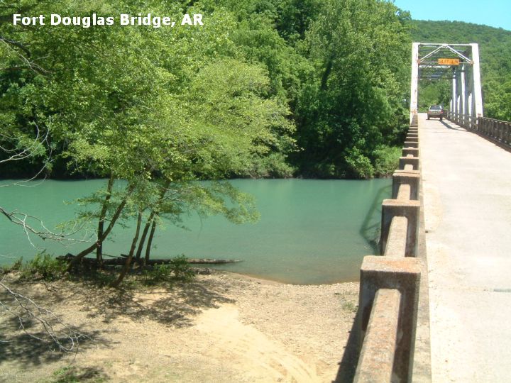
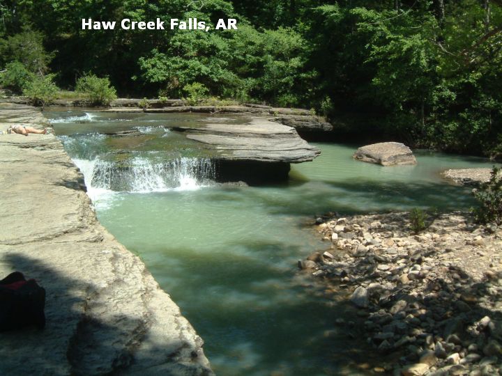
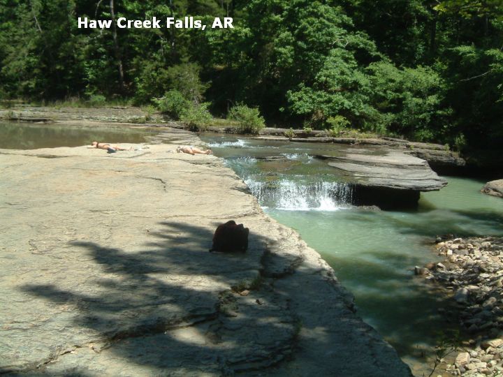
DIRECTIONS | From Russellville (on I-40 about 70 miles northwest of Little Rock) take RT 7 north (through Dover and past the Long Pool Area swimming place) about 65 miles total on RT 7 to Pelsor (also known as Sand Gap). In Pelsor, take RT 123 southwest through Dillen toward the Haw Creek Falls Recreation Area, then: | FORT DOUGLAS BRIDGE [FORT]: Swimming hole in Big Piney Creek under old steel truss bridge. PHOTO . LAT, LON lat=35.67694, lon=-93.235(source: Measured) (accuracy: exact) LINK TO GOOGLE MAP. You cross this bridge after you go through Dillen on RT 123 and just before you get to the Haw Creek Falls campground (below). This from a visitor:" Immediately after crossing the bridge, turn right and drive down under the bridge. The pool under the bridge extends for almost 1/4 mile upstream, providing plenty of room for swimming, fishing, canoeing or general lounging in the sun. There is also an access road on the eastern side of the bridge that provides access to the "high side" (eastern bank) of the creek, including several boulders from which to jump, and, after local rainfall, several waterfalls coming down the mountainside. There was also a rope swing slightly upstream of the bridge on the "low side" (western bank) This area is also full of both Spotted and Smallmouth bass for those wishing to fish. This is also a popular put-in point for the float trip down to Long Pool Campground already listed on your site. THIS IS A PUBLIC ACCESS WITH NO OVERSIGHT. PLEASE PACK IN WHAT YOU PACK OUT AND LEAVE NO TRACE IF CAMPING. WITH YOUR HELP SITES LIKE THESE WILL REMAIN OPEN FOR OUR CHILDREN, AND THEIR CHILDREN. TRASH THESE PUBLIC ACCESSES AND THEY WILL INEVITABLY BE CLOSED OFF" Very confident. Verified 5/09. Updated 6/09. HAW CREEK FALLS [HAWC]: Great swimming hole in Haw Creek at bottom of scenic falls (water a bit shallow) and good picture spot. PHOTO , PHOTO . LAT, LON lat=35.6772, lon=-93.2554(source: Measured) (accuracy: exact) LINK TO GOOGLE MAP. The falls are at the Haw Creek Falls campground (above) just across the road from the vault toilets. Very confident. Verified 5/09. Updated 6/09.
CONFIDENCE | Very confident |
VERIFIED | Yes, 5/09 |
DATE UPDATED | 6/09 | |
|---|
This swimming hole listing is by www.swimmingholes.org
|
TOWNS | LITTLE ROCK, HOT SPRINGS, MOUNTAIN PINE |
STATE | AR |
WATER | Varies-see below |
TYPE | Varies-see below |
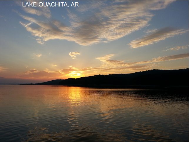
DESCRIPTION | In the downtown of the town of Hot Springs is Hot Springs National Park. The water here is the hottest natural water in the eastern US. The water comes out at 143F and is among the purest waters nationally available. "Bathhouse Row" has existed on Central Ave since the mid-1800's. Today it is a collection of beautiful early and mid-century architecture which house bath facilities, art museums and even a brewpub. (Unfortunately, we have been unable to find any information about hot springs in natural settings such as you might find in the Western US.) The city was the original "Las Vegas"... and was frequented by Chicago mobsters and federal police. Surrounded by Lake Hamilton, the original historic city was build inside the first national reserve (park). | Lake Ouachita is the largest lake nearby. There are four lakes around the city. Ouachita is 26 miles long, has over 200 islands and four marinas. It is all protected land and there is no development. It is on top of the largest quartz crystal deposit in the US. For this and many other reasons, Ouachita is not an average lake by any means. One visit, and you'll agree. It's one of the most beautiful swimming spots to be found anywhere. Hot Springs also has several spring-fed swimming holes.
AREAS | Hot Springs National Park |
SANCTION | Official |
FEE | Varies-see below |
FACILITIES |
All facilities in town. |
ACTIVITIES |
Hot tubbing, Swimming |
PHONE | Varies-see below |
CAMPING | Camping in the Gulpha Gorge campground in Hot Springs National Park. | BATHING SUITS | Required |
DIRECTIONS | From Little Rock take I-30 southwest to Benton then US 70 west to the town of Hot Springs. Then: | BATHHOUSES [BATH]: There are 2 bathhouses (operated as concessions) in the Hot Springs National Park. Both are right downtown on Central Avenue, aka "Bathhouse Row". The first is Buckstaff baths, where you get a traditional hot springs rubdown spa treatment beginning at $33 in this older bath house. Phone: 501-623-2308. The second is the Quapaw Bathhouse, a more modern co-ed facility with private baths and public pools, beginning at $18. Phone: 501-623-2308. LAT, LON lat=34.51240, lon=-93.05393(source: Map) (accuracy: approximate) LINK TO GOOGLE MAP. Very confident. Verified by another. Updated 9/2014. THE ARLINGTON [ARLI]: A grand old fashioned hotel and spa/bathhouse. Private baths and spa treatments.The Arlington Hotel. This is downtown also, at the intersection of Central Ave. and Fountain St. Phone (501) 623-7771. Cost unknown. LAT, LON lat=34.51660, lon=-93.0534(source: Map) (accuracy: approximate) LINK TO GOOGLE MAP. Very confident. Verified by another. Updated 9/2014. The below are all cool-water places on Lake Ouachita, which is northwest of Hot Springs: BLAKELY DAM [BLAK]: Wonderful swimming place at a dam - with an amazing view. PHOTO . Take Albert Pike RT 270 west out of town and turn right (north) on Mountain Pine Rd. - RT 227 (just after the bridge over Lake Hamilton). Take RT 227 north, then near the town of Mountain Pine, continue onto Blakley Dam Rd and follow signs to Blakely Dam. LAT, LON lat=34.56874, lon=-93.19470(source: Map) (accuracy: approximate) LINK TO GOOGLE MAP. Very confident. Verified by another. Updated 9/2014. THREE SISTERS SPRINGS [THRE]:At Lake Ouachita State Park. Old water therapy site with original three springs still there. THREE SISTERS. From Mountain Pine Rd. (RT 227 - above) continue through the town of Mountain Pine. Follow 227 north to Lake Ouachita State Park. (It is not clear if you can actually get into the springs here.) Follow signs to Three sisters. LAT, LON lat=34.61767, lon=-93.1765(source: Map) (accuracy: approximate) LINK TO GOOGLE MAP. Uncertain. Not verified. Updated 9/2014. CRYSTAL SPRINGS BEACH [CRYS]: Army Corps of Engineers swimming beach on Lake Ouachita. Sandy beach and bathroom facilities. Take Albert Pike west out of Hot Springs then turn north onto N. Crystal Springs Rd. (two stores there). Follow to swim area. Fee area. This from a local; "Note: 500 ft past the Crystal Springs Rd. turn-off is a real authentic roadhouse /deli where you can get over-stuffed corned-beef sandwiches and lethal-dose cinnamon buns." LAT, LON lat=34.54149, lon=-93.35066(source: Map) (accuracy: approximate) LINK TO GOOGLE MAP. Very confident. Verified by another. Updated 9/2014.
CONFIDENCE | Very confident |
VERIFIED | By another |
DATE UPDATED | 9/2014 | |
|---|
This swimming hole listing is by www.swimmingholes.org
|
TOWNS | HARRISON, JASPER |
STATE | AR |
WATER | Buffalo River |
TYPE | River |
DESCRIPTION | Several swimming places very close together in the beautiful, blue-green Buffalo River near Jasper. BUFFALO NATIONAL RIVER SITE. For details, see DIRECTIONS below. |
AREAS | Buffalo National River Area |
SANCTION | Unofficial |
FEE | None |
FACILITIES |
All facilities at campgrounds |
ACTIVITIES |
Swimming, jumping |
PHONE | Unknown |
CAMPING | Camping at Ozark, Erbie and Carver National Park Campgrounds |
BATHING SUITS | Customary |
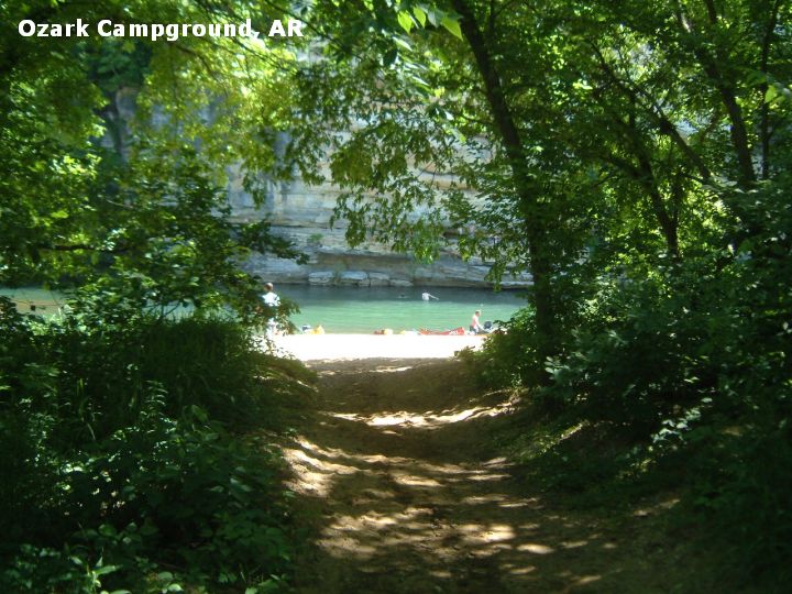
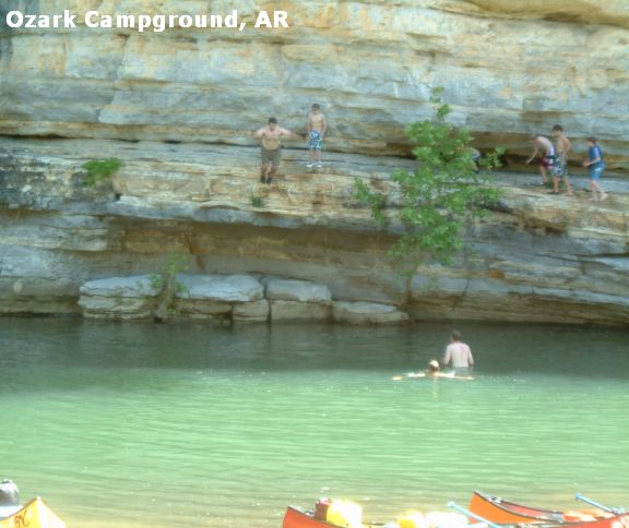
DIRECTIONS | From Harrison (in Northwestern AR) (set odometer) take RT 7 south toward Jasper, then: | PRUITT [PRUI]: Swimming hole in the Buffalo River with a high bluff on far side for jumping. PHOTO . LAT, LON lat=36.06139, lon=-93.138889(source: Measured)(accuracy:exact) LINK TO GOOGLE MAP To get here: Going south on RT 7, about 12 miles from Harrison (7 miles before Jasper), there is a bridge over the Buffalo River. Just past this bridge, on the right is a ranger station. Go into the Ranger Station and park in the rear lot area. Walk down the path to the river - the swimming hole is here. (There is another swimming hole called Pruitt on the north side of this bridge - BEFORE you get to the bridge coming south on RT 7, turn left into a road that winds down to the river - a swimming hole is here also.) Very confident. Verified 5/09. Updated 6/2009. OZARK CAMPGROUND [OZAR]: Very nice, highly recommended swimming hole and fun kids jumping place in the Buffalo River at the Ozark Campground, which is a Buffalo National River campground by the National Park Service. There is a bluff on the far side with several levels for jumping. PHOTO , PHOTO . LAT, LON lat=36.065, lon=-93.159167(source: Measured)(accuracy:exact) LINK TO GOOGLE MAP To get here: Continuing south on RT 7 past Pruitt (above) you will soon come to a sign for the Ozark Campground (before Jasper) - turn west (right) and go about a mile on a dirt road that is sometimes pretty steep (but a car can make it in a lower gear) to the campground. The swimming hole is near the rear of the campground circle. (Nice place to camp but very crowded on summer weekends - no reservations). (If you go a little ways south on RT 7 from here, still not to Jasper, you will see a sign for Erbie Campground. There is swimming here in the Buffalo River also but it is a long dirt road back there and the swimming hole is not as nice as at Ozark or Pruitt (above), so I would only go back there if I needed to camp.) Very confident. Verified 5/09. Updated 6/2009. BRADLEY PARK [BRAD]: Pretty nice, easily accessible swimming place in the Buffalo River right in a town park in Jasper. PHOTO . LAT, LON lat=36.00861, lon=-93.190278(source: Measured)(accuracy:exact) LINK TO GOOGLE MAP To get here: Continue south on RT 7 into Jasper. Near the courthouse, turn right onto Clark St. and continue to the park at the end of Clark St.. Keep to the right in the park and go down to the river near the picnic pavilion. Very confident. Verified 5/09. Updated 6/2009.
CONFIDENCE | Very confident |
VERIFIED | Yes, 5/09 |
DATE UPDATED | 6/09 | |
|---|
This swimming hole listing is by www.swimmingholes.org
|
TOWNS | LITTLE ROCK, BENTON, SHERIDAN | LAT, LON | lat=34.21094, lon=-92.54858(source: DeLorme) (accuracy:general area) | LINK TO GOOGLE MAP
STATE | AR |
WATER | Saline River |
TYPE | River |
DESCRIPTION | Swimming hole in the Saline River at State Historical Park. Don't know if this is an official swimming place or not. No better description. |
AREAS | Jenkins Ferry State Historical Monument |
SANCTION | Unknown |
FEE | Unknown |
FACILITIES |
None |
ACTIVITIES |
Swimming |
PHONE | None |
CAMPING | No camping at site. Camping west of here in Ouachita N. F., |
BATHING SUITS | Unknown |
DIRECTIONS | From Little Rock, take I-30 southwest about 15 miles to Benton area. From Benton, take RT 35 southeast about 17 miles to Sheridan. From Sheridan, take RT 46 southwest about 10 miles to sign for state park. Swimming place is in Saline River here. No better directions. [See also nearby Saline River swimming holes at "Benton", "Jenkins Ferry", "Farindale" and "Rye".] |
CONFIDENCE | Pretty confident |
VERIFIED | No |
DATE UPDATED | 9/11/2001 | |
|---|
This swimming hole listing is by www.swimmingholes.org
|
TOWNS | CLARKSVILLE, OZONE, BOSTON | LAT, LON (PARKING) | lat=35.89454, lon=-93.58510 (source: map) (accuracy:approximate) | LINK TO GOOGLE MAP
STATE | AR |
WATER | Kings River |
TYPE | Falls |
DESCRIPTION | Beautiful falls with broad, deep pool below. (see video above). |
AREA | Kings River Falls Natural Area |
SANCTION | Unofficial |
FEE | None |
FACILITIES |
None |
ACTIVITIES |
Jumping, Swimming |
PHONE | Unknown |
CAMPING | No camping at site. Lots of camping at National Forest south of here. |
BATHING SUITS | Unknown |
DIRECTIONS | From Clarksville on I-40, take RT 21 north for 28 miles then take RT 16 northwest for about 16 miles (winds around a lot) to Boston. From Boston go north on County Road 3175 (dirt) for 2.1 miles. Bear right as the road forks onto County Road 3415. Stay on this road for 2.3 miles until you come to a "T" intersection with County Road 3500. Turn left, and go across the creek and park at the natural area sign. | The trail begins at the parking area. It parallels Mitchell Creek for the first 1/10 mile. It then turns north along the Kings River. You cross one small bridge about .5 miles in. Continue to the scenic Kings River Falls. Swim in the pool below the falls. The falls are at: LAT, LON (FALLS): lat=35.89844, lon=-93.57631 (source: map) (accuracy:approximate) LINK TO GOOGLE MAP
CONFIDENCE | Pretty confident |
VERIFIED | No |
DATE UPDATED | 12/2012 | |
|---|
This swimming hole listing is by www.swimmingholes.org
|
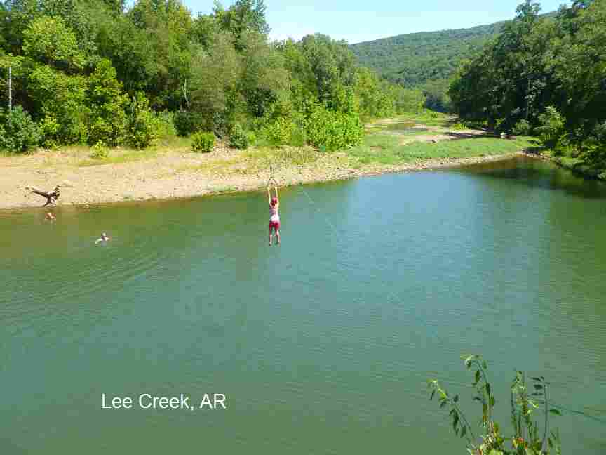
TOWNS | FORT SMITH, CEDARVILLE, NATURAL DAM |
STATE | AR |
WATER | Lee Creek |
TYPE | Creek |
DESCRIPTION | Popular swimming holes in Lee Creek in the Ozark National Forest. For details, see DIRECTIONS below. SNAKE ALERT AREA |
AREAS | Ozark National Forest |
SANCTION | Unofficial |
FEE | None |
FACILITIES |
None |
ACTIVITIES |
Swimming, jumping, zip line |
PHONE | Unknown |
CAMPING | North of here at Devils Den S. P. (Gravel road from Lee Creek to Devils Den) |
BATHING SUITS | Customary |
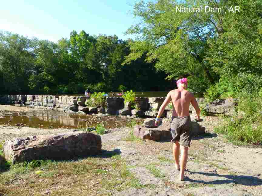
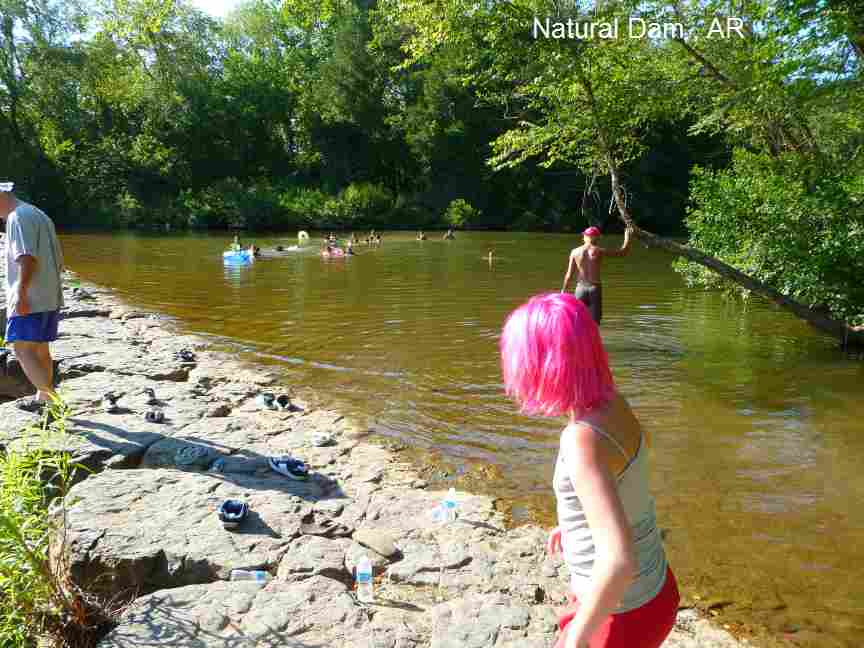
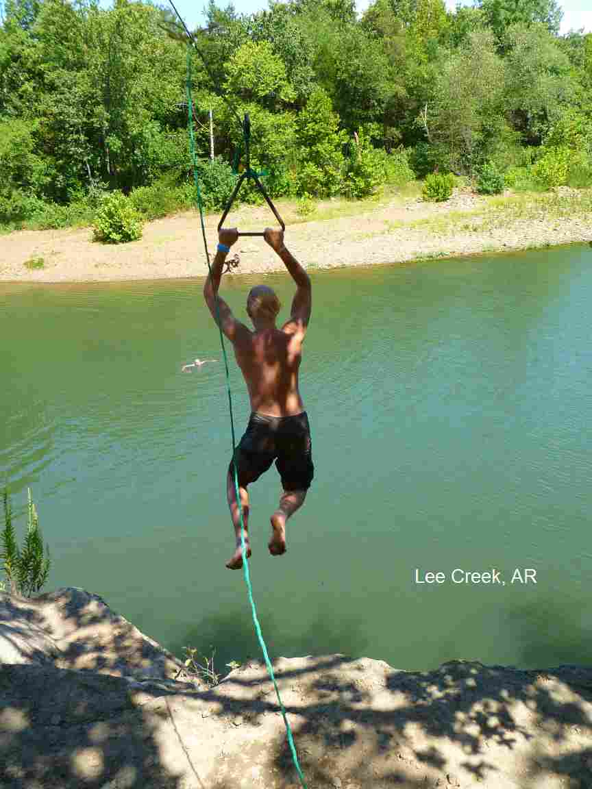
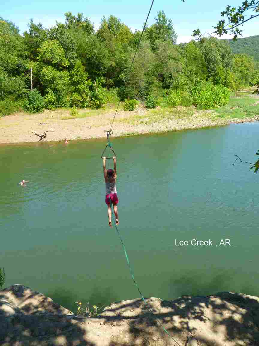
DIRECTIONS | From Fort Smith/Van Buren, take RT 59 north through Cedarville then take RT 59/220 north a short way until you come to the split of RT 220 and RT 59. Then: | NATURAL DAM [NATU]: This hole in Lee Creek is managed by the US Forest Service, info can be found here . Picnic tables and toilets. Semi-official area, no lifeguards. PHOTO , PHOTO. This report from a visitor in 8/10: "The water here has been pretty stagnant for most of the summer, so it's not the best place to go late in the season. However, I bet this place really rocks during late spring and early summer. In addition to the big hole located at the dam itself, there are some nicely maintained trails that go downstream to what look like great swimming holes when the water is running." To get here from the split of RT 220 and RT 59, keep left and take RT 59 north. Go to the town of Natural Dam then turn west (left) off RT 59 in Natural Dam (it's the only intersection in town). Go about .25 miles down the road to Lee Creek and the swimming hole. In addition to the swimming hole, there are some very nice trails and picnic sites here. LAT, LON lat=35.64987, lon=-94.39775(source: DeLorme) (accuracy: approximate) LINK TO GOOGLE MAP. Very confident. Verified by another. Updated 8/10. LEE CREEK [LEEC]:Huge, popular (unofficial) swimming hole at large rock in Lee Creek. Zip line in place sometimes! See photos. This report from a visitor in 8/10: "Definitely a cool place to visit. In addition to the great water, some enterprising soul has installed a zip line from the cliffs above and you can jump from the top of the cliff (about a 40 foot drop to the water) and ride the zip line to where the water is deep enough to drop in. Maybe not the safest thing in the world, but my kids all went on it and we had a great day there." PHOTO , PHOTO , PHOTO , PHOTO , YOUTUBE . To get here from the split of RT 220 and RT 59, keep right and take RT 220 north. Go about 10 miles on RT 220, then, as you approach the bridge over Lee Creek, there is a turn off on the east side (right side) just before the bridge that goes down to a large parking area and the swimming hole. The swimming hole can be seen from the bridge. LAT, LON lat=35.70333, lon=-94.32722(source: measured) (accuracy: approximate) LINK TO GOOGLE MAP. Very confident. Verified 5/09. Updated 8/10.
CONFIDENCE | Very confident |
VERIFIED | Yes |
DATE UPDATED | 8/10 | |
|---|
This swimming hole listing is by www.swimmingholes.org
|
TOWNS | GLENWOOD, LANGLEY |
LAT, LON | lat=34.3725, lon= -93.87944(source: Topozone ) (accuracy: general area) | LINK TO GOOGLE MAP
STATE | AR |
WATER | Little Missouri River |
TYPE | River |
DESCRIPTION | Several swimming places in the Little Missouri River in the Ouachita N. F. near the Albert Pike Campground along the Little Missouri Trail. For details, see DIRECTIONS below. SNAKE ALERT AREA [See also "CHARLTON" swimming place nearby]
|
AREAS | Ouachita N. F. |
SANCTION | Unofficial |
FEE | None |
FACILITIES |
Probably picnic tables, toilets in campground |
ACTIVITIES |
Swimming |
PHONE | Unknown |
CAMPING | Nearby Albert Pike Campground closed due to tragic flood in 6/2010. |
BATHING SUITS | Unknown |
DIRECTIONS | From Hot Springs, go southwest on RT 70 to Salem, then west on RT 84 to Langley. In Langley, go north on RT 369 into the N. F. to the Albert Pike Campground. Then: | ALBERT PIKE [ALBE]: There is a swimming place is in the river near the Albert Pike Campground. Albert Pike Campground may still be closed due to a tragic (multiple fatalities) flood in 6/2010. The swimming place is in the "A" loop in the campground. LAT, LON lat=34.37583, lon=-93.87689(source: DeLorme) (accuracy: approximate) LINK TO GOOGLE MAP. WINDING STAIRS [WIND]: There is another swimming place just south of here on the Little Missouri River in an area called the "Winding Stairs" where there are many cascades and swimming holes. (See link to photos, above - see local area map, above). You can hike here along the Little Missouri Trail (south from Albert Pike - about 3 miles hike one way). LAT, LON lat=34.35467, lon=-93.90667(source: DeLorme) (accuracy: general area) LINK TO GOOGLE MAP. To go part way by car: From the Albert Pike campground take Forest Rd. 106/County Rd 82 west for about 2 miles. There is a well marked parking area on the left that says Winding Stairs trail. (There may also be a swimming place along this road BEFORE you get to Winding Stairs - may be known locally as a "Blue Hole".) There is a restroom at the parking area. Hike about 1.5 miles, four river crossings on the trail, and you will be at "the stairs." There are some very deep pools at the base, and tubing down the stairs is fun. LITTLE MISSOURI FALLS [LITF]: Another popular swimming place very near here is the Little Missouri Falls. (See link to photos, above - see local area map, above). You can hike here along the Little Missouri Trail about 6.3 miles. (north from Albert Pike Campground Area B). By car from Albert Pike Campground, go north on RT 369 about 2.5 miles (becomes dirt road, also becomes FR 73) then west (left) on Crooked Creek Rd (FR 43) for about 4.5 miles then west (left) on Mine Creek Rd (FR 25) about .75 miles to the left turn-off to Little Missouri Falls Day Use Area. LAT, LON lat=34.42458, lon=-93.92806(source: DeLorme ) (accuracy: approximate) LINK TO GOOGLE MAP BLUE HOLE QUARRY : Verified on 4/13/2020, this swimming hole is now closed. It is located on private property and is no longer available to the public. Please respect the landowners and do not visit this quarry.
CONFIDENCE | Very confident |
VERIFIED | Yes |
DATE UPDATED | 4/13/2020 | |
|---|
This swimming hole listing is by www.swimmingholes.org
|
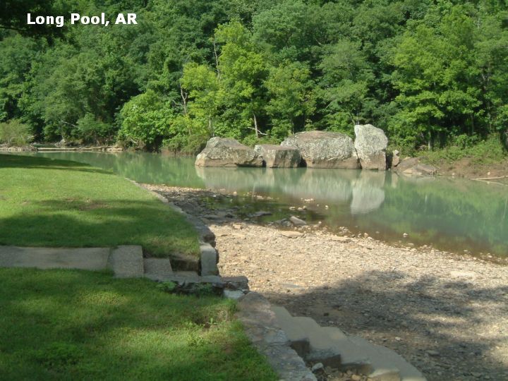
TOWNS | RUSSELLVILLE, DOVER |
STATE | AR |
WATER | Big Piney Creek |
TYPE | Creek |
DESCRIPTION | Several swimming places in Big Piney Creek in the Ozark N.F.. SNAKE ALERT AREA |
AREAS | Ozark N. F. - Central Unit |
SANCTION | Unofficial |
FEE | None |
FACILITIES |
All facilities in Long Pool Campground |
ACTIVITIES |
Swimming |
PHONE | Unknown |
CAMPING | Camping at Long Pool |
BATHING SUITS | Customary |
DIRECTIONS | From Russellville (on I-40 about 130 miles northwest of Little Rock) take scenic RT 7 north through Dover to where RT 164 goes west (not east) then go west 4 miles on RT 164. Here you will see signs here to Long Pool Recreation Area. [See also "Ben Hur Area" nearby swimming holes.]. Then: |
SLANT ROCK [SLAN]: Swimming hole at very large slanted rock that is partially submerged in Big Piney Creek in Ozark N.F. - Central Unit on the road to Long Pool. There is a rope swing here that you can use that will get you anywhere from 5 to 25 feet off the water. PHOTO . The swimming hole is about 100 feet across, 300 feet long and 20 feet deep. SNAKE ALERT AREA. National Forest developed camping and other facilities at Long Pool. LAT, LON : lat=35.5365, lon=-93.1521(source: Measured) (accuracy:exact) , LINK TO GOOGLE MAP. To get here, on the road to Long Pool, about .9 miles before you get to Long Pool, there is a large unmarked parking spot on the left side of the road (at 35.5367, -93.1520). You will know you have the right location by the angle the (wide) trail leaves the parking area. The trail runs basically parallel back along the road. The rest of the parking areas either allow for vehicle access, or they turn 90 degrees off the main road. But, with the number of locals that visit this swimming hole, the parking place should be easy to spot. Follow this trail about a .25 mile hike to slant rock. Very confident. Verified 5/09. Updated 6/2009.
CONFIDENCE | Very Confident |
VERIFIED | Yes, 5/09 |
DATE UPDATED | 6/09 | |
|---|
This swimming hole listing is by www.swimmingholes.org
|
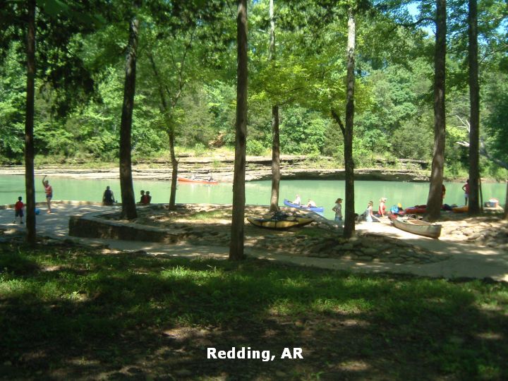
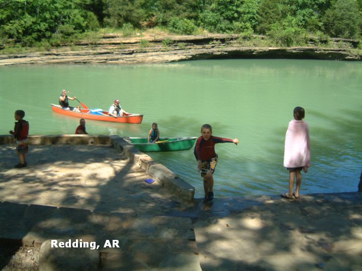
TOWNS | FORT SMITH, OZARK |
STATE | AR |
WATER | Mulberry River |
TYPE | River |
DESCRIPTION | There are said to be several real old fashioned swimming holes in this section of the Mulberry River. No better description. SNAKE ALERT AREA |
AREAS | Ozark N. F. - Central Unit |
SANCTION | Unofficial |
FEE | None |
FACILITIES |
Unknown |
ACTIVITIES |
Swimming |
PHONE | Unknown |
CAMPING | Both at Redding and Wolf Pen |
BATHING SUITS | Required |
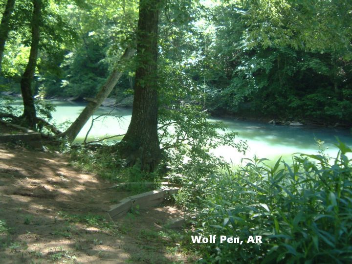
DIRECTIONS | From Fort Smith, go east on I-40 about 30 miles to the town of Ozark. From Ozark, go north on RT 23 into the Ozark N.F. and to the area of the Mulberry River. Turn east (right) from RT 23 onto RT 215, drive along the Mulberry River, then: | REDDING [REDD]: A National Forest campground that is also a popular access point for Mulberry River canoe trips. Nice river access point with tables and toilets but very busy on summer weekends (Wolf Pen, below, is quieter). PHOTO , PHOTO . SNAKE ALERT AREA. LAT, LON : lat=35.68194, lon=-93.78694(source: Measured) (accuracy:exact) LINK TO GOOGLE MAP. To get here, continue east on RT 215 to the signs for Redding Rec Area. Very confident. Verified 5/09. Updated 6/09. WOLF PEN [WOLF]: A National Forest campground that also has a swimming hole (and small canoe launch) on the Mulberry River. PHOTO , PHOTO . SNAKE ALERT AREA. LAT, LON : lat=35.67556, lon=-93.63027(source: Measured) (accuracy:exact) LINK TO GOOGLE MAP. To get here, continue east on RT 215 to the signs for Wolf Pen Rec Area. Very confident. Verified 5/09. Updated 6/09.
CONFIDENCE | Very confident |
VERIFIED | Yes, 5/09 |
DATE UPDATED | 6/09 | |
|---|
This swimming hole listing is by www.swimmingholes.org
|
TOWNS | JONESBORO, WALNUT RIDGE, POCAHONTAS | LAT, LON | lat=36.15269, lon=-91.05278(source: DeLorme) (accuracy:approximate) | LINK TO GOOGLE MAP
STATE | AR |
WATER | Black River |
TYPE | River |
DESCRIPTION | Swimming from a dock in the Black River. |
AREAS | Old Davidsonville S. P. |
SANCTION | Official |
FEE | Unknown |
FACILITIES |
All facilities |
ACTIVITIES |
Swimming, Hiking, Boating |
PHONE | (501)892-4708 |
CAMPING | Camping at site. |
BATHING SUITS | Required |
DIRECTIONS | From Jonesboro (in the northeast corner of the state) , take RT 63 to the northwest past Walnut Ridge to Black Rock. In Black Rock, take RT 62 north to RT 361 north then 6 miles more to the state park. Swim from the dock in the state park. |
CONFIDENCE | Pretty confident |
VERIFIED | No |
DATE UPDATED | 9/11/2001 | |
|---|
This swimming hole listing is by www.swimmingholes.org
|
TOWNS | MOUNTAIN HOME, MOUNTAIN VIEW |
STATE | AR |
WATER | Sylamore Creek |
TYPE | Varies, see below |
DESCRIPTION | Varies, see below. SNAKE ALERT AREA |
AREAS | Ozark N. F. North Unit |
SANCTION | Varies - see below |
FEE | None |
FACILITIES |
All facilities in Blanchard Springs Cavern S. P. |
ACTIVITIES |
Swimming |
PHONE | Unknown |
CAMPING | There is camping at the Blanchard Springs Cavern S. P. and several of these sites in the Ozark N F. |
BATHING SUITS | Unknown |
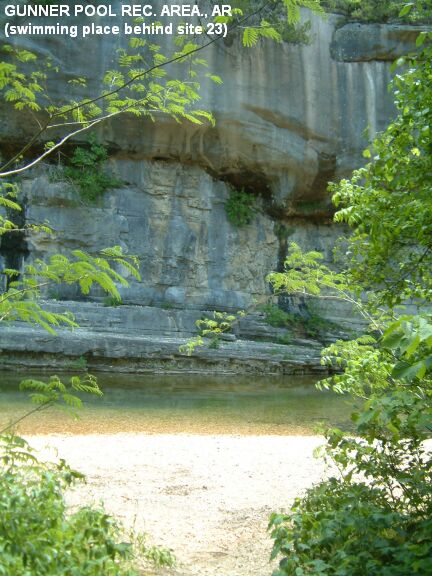
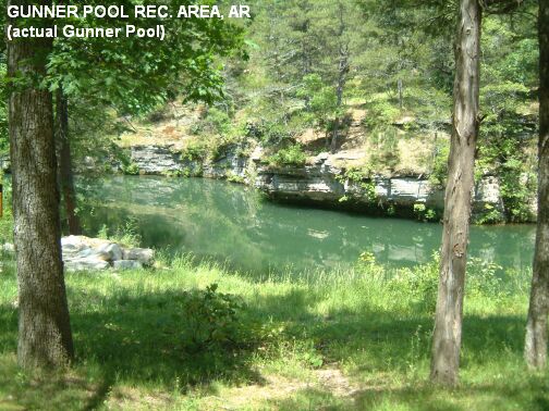
DIRECTIONS | From Mountain Home in the north-central part of AR (due north of Little Rock, very near the Missouri border) take RT 5 southeast about 40 miles to Sylamore. From Sylamore, take RT 14 west into the Ozark N. F. Then: | BLANCHARD SPRINGS CAVERNS S. P. [BLAN]: This is on RT 14 just west of Sylamore. LAT, LON lat=35.96344, lon=-92.17117(source: DeLorme ) (accuracy: approximate) LINK TO GOOGLE MAP The caverns are pretty spectacular. The springs themselves are scenic and cool PHOTO OF SPRINGS but not really a swimming place. If you follow the swimming signs in the park, you will come to an official swimming place with beach and changing rooms PHOTO OF MAIN HOLE - popular but still not the best. The best swimming hole is in the campground, very apparent on your right as you get to the beginning of the loop for sites 16-31. PHOTO OF CAMPGROUND SWIMMING HOLE . Both swimming places are official and there is a day use fee of $3.00 for both swimming places. Camping at the site. Phone number for the caverns is (888) 757-2246. Very confident. Verified 5/05. Updated 5/27/05. GUNNER POOL [GUNN]: Two swimming places. One is behind campsite #23 PHOTO 1 , with a beach and gradual entry. Gunner Pool itself is behind campsite #17, has no beach and is quite deep - behind a dam. PHOTO 2 . Camping at the site. LAT, LON lat=35.99222, lon=-92.21092(source: Topozone ) (accuracy: exact) LINK TO GOOGLE MAP Continue on RT 14 west past Blanchard Springs Caverns and through the village of Fifty Six, then go 4 miles north (right) on CR 26 (FR 1102) to signs for Gunner Pool recreation area. Very confident. Verified 5/05. Updated 5/27/05. BARKSHED [BARK]: Continue north on FR 1102 (CR 26) about 4 miles then turn left on CR 1113 (unknown Forest road) toward the town of Big Flat for about 2 miles to the Barkshed Rec Area, which is probably signed. LAT, LON lat=36.01867, lon=-92.25003 (source: Topozone ) (accuracy: approximate) LINK TO GOOGLE MAP The swimming hole is a hike from this campground. No better directions or description. Pretty confident. Not verified. Updated 5/27/05.
CONFIDENCE | Varies, see above |
VERIFIED | Varies, see above |
DATE UPDATED | 5/27/2005 | |
|---|
This swimming hole listing is by www.swimmingholes.org
|
TOWNS | LITTLE ROCK, CONWAY, MORRILTON, RUSSELLVILLE |
LAT, LON | lat=35.11731, lon= -92.9362(source: Map) (accuracy: approximate) | LINK TO GOOGLE MAP
STATE | AR |
WATER | Cedar Creek |
TYPE | Creek/Falls |
DESCRIPTION | NOTE: We received this warning in 3/2014: "There is no swimming allowed at Petit Jean State Park, Cedar Falls or Cedar Creek except in the public pool open from Memorial Day to Labor Day. Park Superintendent." | Besides the pool, there are two places where people access the water in the gorge of Cedar Creek in Petit Jean State Park (the oldest state park in AR). STATE PARK INFO , TRAILS MAP . One place is at the bottom of the beautiful, 95 foot Cedar Creek Falls CEDAR FALLS TRAIL INFO . CAUTION: The rocks at the bottom of the falls are VERY slippery - get down low and use your hands and butt to navigate them safely. Another place is downstream from the falls at a place called the "Blue Hole" where CCC workers used to swim CANYON TRAIL INFO . Both require about a 2 mile round trip hike and both start behind the Mather Lodge at the breezeway (both trails run together in the beginning). It is steep coming back up! See directions below for details.
AREAS | Petit Jean State Park |
SANCTION | Swimming permitted only in the pool |
FEE | Unknown |
FACILITIES |
All facilities at Mather Lodge |
ACTIVITIES |
Water play |
PHONE | 501-727-5441 (State Park) |
CAMPING | On site Petit Jean State Park |
BATHING SUITS | Required |
DIRECTIONS | From Little Rock, take I-40 west to Exit 108 at Morrilton. Go nine miles south on RT 9, then go 12 miles west on RT 154 to Petit Jean S. P.. Park at Mather Lodge and find the trailhead at the breezeway behind Mather Lodge. (Best to get a detailed trail map at the lodge). | The "Cedar Falls Trail" and the "Canyon Trail" run together down into the gorge and across Cedar Creek on the footbridge. After you cross the footbridge, you turn right to take "Cedar Falls Trail" upstream to the bottom of Cedar Falls. You turn left to take "Canyon Trail" downstream to the historic Blue Hole. Return the way you came.
CONFIDENCE | Pretty confident |
VERIFIED | No |
DATE UPDATED | 3/2014 | |
|---|
This swimming hole listing is by www.swimmingholes.org
|
TOWNS | JASPER, PONCA |
STATE | AR |
WATER | Buffalo River |
TYPE | River |
DESCRIPTION | Swimming holes in the clean, clear waters of Buffalo River. SNAKE ALERT AREA |
AREAS | Buffalo National River Area |
SANCTION | Unofficial |
FEE | None |
FACILITIES |
All facilities at Steel Creek campground |
ACTIVITIES |
Swimming |
PHONE | Unknown |
CAMPING | Camping at Steel Creek campground and Lost Valley campground in the Ozark N F. | BATHING SUITS | Customary |
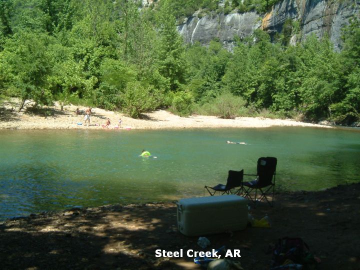
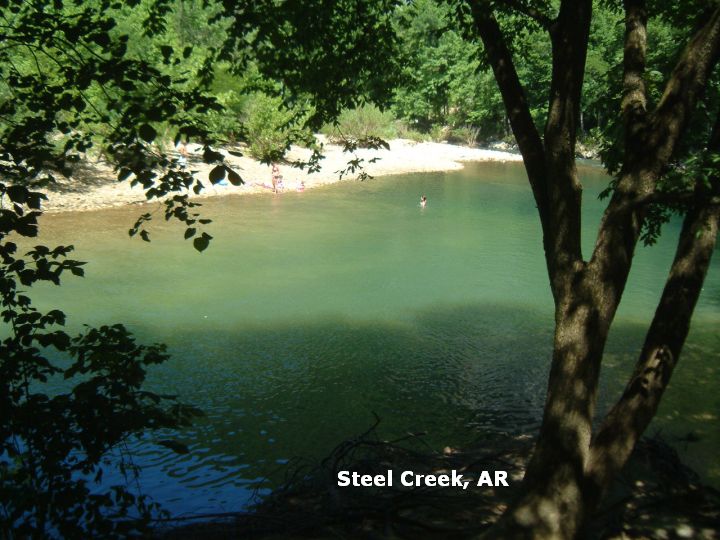
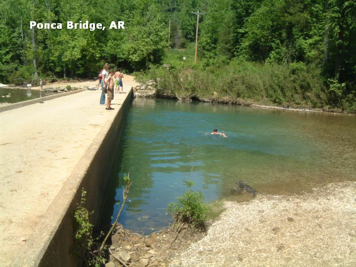
DIRECTIONS | From Harrison in the north-west part of AR (very near the Missouri border) take RT 7 south about 20 miles to Jasper (see JASPER AREA swimming holes) then take RT 74 west about 11 miles toward Ponca, then: | STEEL CREEK [STEE]: Swimming places in the Buffalo River in the Steel Creek (National Forest) campground. Many areas behind the campsites may be shallow, but a good deep place is in the river near the horse camping section of the campground, below some riffles in the river. May have to swim here across the river for the best gravel beach area. PHOTO , PHOTO . Camping at site. LAT, LON lat=36.03885, lon=-93.3358(source: Measured) (accuracy: exact) LINK TO GOOGLE MAP. To get here, go west on RT 74 until you see the sign for the Steel Creek campground. Go to the horse camp area, the swimming hole is here in the river. Very confident. Verified 5/09. Updated 6/09. PONCA BRIDGE [PONC]: Swimming place at low water bridge in the Buffalo River. Camping nearby at Steel Creek or Lost Valley (National Forest) campgrounds. PHOTO . LAT, LON lat=36.02111, lon=-93.35472(source: Measured) (accuracy: exact) LINK TO GOOGLE MAP. To get here, continue west on RT 74 then turn south on RT 43 at Ponca. After you turn south on RT 43, make an immediate left on a road the goes down to the river at the low water bridge. The swimming place is here at the bridge. Very confident. Verified 5/09. Updated 6/09.
CONFIDENCE | Very confident |
VERIFIED | Yes, 5/09 |
DATE UPDATED | 6/09 | |
|---|
This swimming hole listing is by www.swimmingholes.org
|
TOWNS | RUSSELLVILLE, WITTS SPRINGS |
STATE | AR |
WATER | Richland Creek/ Falling Water Creek |
TYPE | Creek |
DESCRIPTION | Deep, cold swimming holes in N.F.. For details, see DIRECTIONS below. SNAKE ALERT AREA |
AREAS | Ozark N. F. - Central Unit |
SANCTION | Unofficial |
FEE | None |
FACILITIES |
Picnic tables, vault toilets at Richland Creek Campground |
ACTIVITIES |
Swimming |
PHONE | Unknown |
CAMPING | Camping at Richland Creek Campground, pretty rustic, rough road, no RV's. |
BATHING SUITS | Unknown |
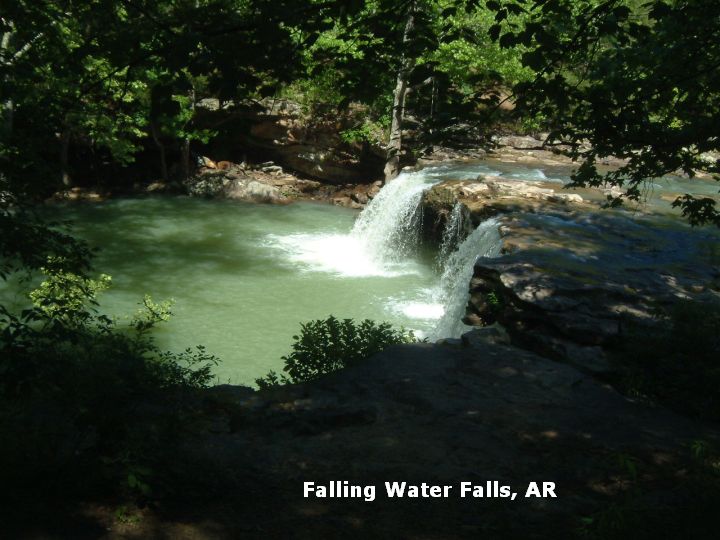
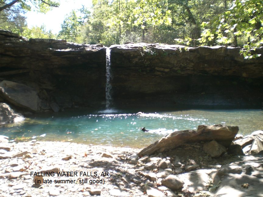
DIRECTIONS | From Russellville (on I-40 about 70 miles northwest of Little Rock) take RT 7 north about 40 miles (past the turn off to "Long Pool Area" swimming hole) to Pelsor (also known as Sand Gap). At Pelsior, take RT 16 east through Ben Hur, then: | FALLING WATER FALLS [FALL]: Swimming place in Falling Water Creek at base of wide, beautiful water fall. PHOTO , PHOTO . Camping at Richland Creek (below). LAT, LON lat=35.721944, lon=-92.9494(source: Measured) (accuracy: exact) LINK TO GOOGLE MAP. To get here from Ben Hur, continue a short way on RT 16 then turn east (left) on CR68/FR 1205. Go about 2.25 miles (gravel road) then park in a turn out on the right - the falls are visible from the road. Very confident. Verified 5/09. Updated 6/09. RICHLAND CREEK [RICH]: Swimming place in Richland Creek by large boulders in N.F. campground. Deep, cold swimming hole at Richland Creek Campground. (Other holes are said to be along Richland Creek on the trail that goes along this creek to Richland Falls and Twin Falls. To follow the trail to more swimming holes, park at the lower campground and take the trail west from here. It is about 2.5 miles of rugged hiking (crossing creeks several times) to go all the way to the falls. (May be swimming at Twin Falls too, not sure. See ARKANSAS WATERFALLS for more information.) SNAKE ALERT AREACamping at site. LAT, LON lat=35.79747, lon=-92.93211 (source: Measured) (accuracy: exact) LINK TO GOOGLE MAP. To get here from Falling Water Falls (above), continue north on CR68/FR 1205 (gravel road, sometimes rough) to the campground. Swimming hole is in campground. Very confident. Not verified. Updated 6/09.
CONFIDENCE | Very confident |
VERIFIED | See above |
DATE UPDATED | 6/09 | |
|---|
This swimming hole listing is by www.swimmingholes.org
|
TOWNS | GLENWOOD, LANGLEY |
LAT, LON | lat=34.63972, lon= -93.62583(source: Topozone ) (accuracy: exact) | LINK TO GOOGLE MAP
STATE | AR |
WATER | Ouachita River |
TYPE | River |
DESCRIPTION | Swimming place in the Ouachita river at the River Bluff Float Camp; also a put in place for river canoe trips. Camp is well shaded, with high bluff over swimming place. SNAKE ALERT AREA |
AREAS | Ouachita N. F. |
SANCTION | Unofficial |
FEE | Unknown |
FACILITIES |
Probably picnic tables, toilets in campground |
ACTIVITIES |
Swimming |
PHONE | Unknown |
CAMPING | Camping at site. |
BATHING SUITS | Unknown |
DIRECTIONS | From Hot Springs, go west on RT 270 [past "Charlton" swimming place] and, just past Mt. Ida, go east (right) on RT 27. In a short distance, go north (left) on County Road 59 (if you get to Sweethome on Rt 27, you've gone much too far). Continue on CR 59 until you see signs for the River Bluff Float Camp (I think). You can swim in the river at this camp. |
CONFIDENCE | Uncertain on directions |
VERIFIED | No |
DATE UPDATED | 3/4/2002 | |
|---|
This swimming hole listing is by www.swimmingholes.org
|
TOWNS | LITTLE ROCK, BENTON, SHERIDAN, FORDYCE, WARREN | LAT, LON | lat=33.70097, lon=-92.02650(source: DeLorme) (accuracy:approximate) | LINK TO GOOGLE MAP
STATE | AR |
WATER | Saline River |
TYPE | River |
DESCRIPTION | Swimming hole in the Saline River at Rye. No better description. |
AREAS | None |
SANCTION | Unknown |
FEE | Unknown |
FACILITIES |
None |
ACTIVITIES |
Swimming |
PHONE | None |
CAMPING | No camping at site. Camping Mark's Mill Battleground Historical Monument northwest of here. |
BATHING SUITS | Unknown |
DIRECTIONS | From Little Rock, take I-30 southwest about 15 miles to Benton area. From Benton, take RT 35 southeast about 17 miles to Sheridan. From Sheridan, take RT 167 south to Fordyce. From Fordyce, take RT 8 southeast to Warren. From Warren, take RT 63 (or is it RT 15 ?) north to Rye where the road crosses the Saline River. Swimming place is in Saline River here. No better directions. [See also nearby Saline River swimming holes at "Benton", "Jenkins Ferry", "Farindale" and "Rye".] |
CONFIDENCE | Pretty confident |
VERIFIED | No |
DATE UPDATED | 9/11/2001 | |
|---|
This swimming hole listing is by www.swimmingholes.org
|
TOWNS | HARRISON, ST. JOE, GILBERT |
STATE | AR |
WATER | Buffalo River |
TYPE | River |
DESCRIPTION | Very beautiful swimming holes in the clean, clear waters of Buffalo River. BE CAREFUL OF CURRENTS IF THE RIVER IS HIGH. BUFFALO NATIONAL RIVER SITE. For details, see DIRECTIONS below. |
AREAS | Buffalo National River Area |
SANCTION | Unofficial |
FEE | None |
FACILITIES |
Varies - see below |
ACTIVITIES |
Swimming, jumping |
PHONE | Unknown |
CAMPING | Very nicely developed camping at Tyler Bend. |
BATHING SUITS | Customary |
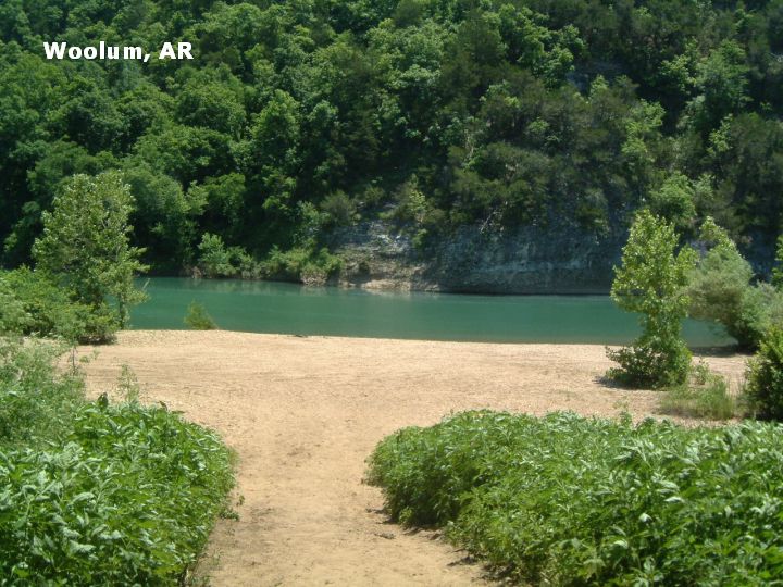
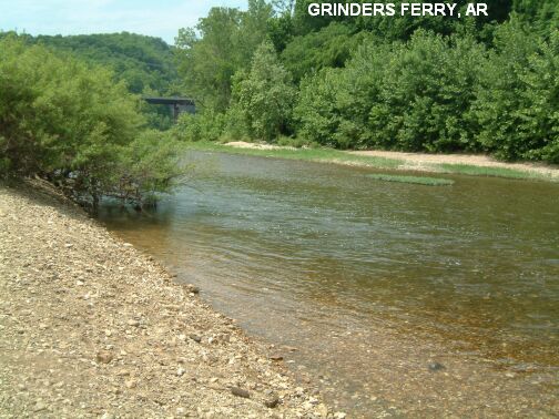
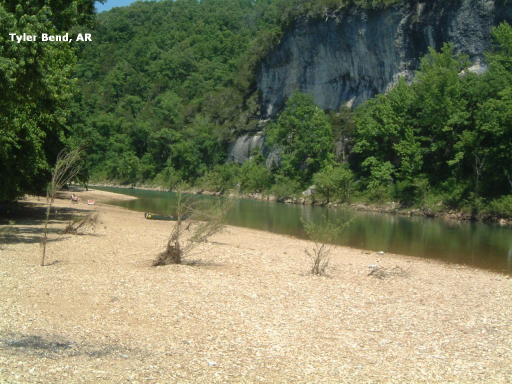
DIRECTIONS | From Harrison (in the north-central part of AR) take RT 65 southeast to St. Joe (all directions below are from St. Joe), then: | WOOLUM [WOOL]: Very beautiful, often very quiet, swimming hole in the Buffalo River with a high bluff on the far side. This is very near the river access point and camping area marked as "Woolum" on the Buffalo National River brochure map. This is a very primitive camping area, with no tables or drinking water and vault toilets. PHOTO . LAT, LON lat=35.97083, lon=-92.87944(source: Measured)(accuracy:exact) LINK TO GOOGLE MAP To get here: From RT 65 in St. Joe, take RT 374 west for about 7 miles, keeping right at the fork (turns into dirt road but car accessible) to the Woolum river access point. When you get down near the river, go left to the primitive camping area, also near the river. The swimming hole is at the far end of the camping area. Very confident. Verified 5/09. Updated 6/09. GILBERT BAR [GILB]: Water play place (pretty shallow) at gravel bar in the Buffalo River at the town of Gilbert. LAT, LON lat=35.9866, lon=-92.7150(source: DeLorme)(accuracy:exact) LINK TO GOOGLE MAP To get here: Go south on RT 65 from St. Joe, then, before you cross the Buffalo River turn east (left) on RT 333. Go to Gilbert; follow signs to Gilbert Bar. The swimming hole is in the Buffalo River in Gilbert. Very confident. Verified 5/09. Updated 6/09. GRINDERS FERRY [GRIN]: Water play place (pretty shallow except for one deep area) at canoe put in the Buffalo River. Not the best swimming hole in the area, but very close to RT 65. PHOTO . LAT, LON lat=35.9847, lon=-92.7444(source: DeLorme)(accuracy:exact) LINK TO GOOGLE MAP To get here: Continue south on RT 65, then, immediately after you cross the Buffalo River going south on RT 65, the road to Grinders Ferry is signed your left. Very confident. Verified 5/09. Updated 6/09. TYLER BEND [TYLE]: Very nicely developed campground (reservations available) with canoe access and good swimming hole in a bend in the Buffalo River. PHOTO . LAT, LON lat=35.9845, lon=-92.7647(source: DeLorme)(accuracy:exact) LINK TO GOOGLE MAP To get here: After you cross the Buffalo River and pass Grinders Ferry going south on RT 65, see signs to Tyler Bend on your right. When you get to Tyler Bend area, go to the parking area for river access, walk to the river and then walk to the left a bit along the river bank to get to the deep place across from the high bluff. Very confident. Verified 5/09. Updated 6/09.
CONFIDENCE | Very confident |
VERIFIED | Yes, 5/00 |
DATE UPDATED | 6/09 | |
|---|
This swimming hole listing is by www.swimmingholes.org
|
TOWNS | JONESBORO, WALNUT RIDGE, HARDY, MAMMOTH SPRING | LAT, LON | lat=36.3897, lon=-91.5269(source: DeLorme) (accuracy: general area) | LINK TO GOOGLE MAP
STATE | AR |
WATER | Spring River |
TYPE | River |
DESCRIPTION | Spring River begins in Missouri and enters Arkansas where Mammoth Spring flows into it, adding about nine million gallons of water per hour. Here the river begins a much higher flow, very popular for tubing, canoeing and swimming in the occasional deep spots. There are local outfitters with canoe and tube rentals. The Spring River is one of Arkansas's more accessible streams, with RT 63 paralleling much of its length. Major public access points include Cold Springs and Dam #3 off RT 63 between Hardy and Mammoth Spring, Bayou Access off RT 289, Hardy Beach, the Wilford Launch Area off RT 58, two put-in/take-out points at Ravenden, and a final launch site at Imboden. No better information about where the deeper spots are. |
AREAS | None |
SANCTION | Unofficial |
FEE | Unknown |
FACILITIES |
Unknown |
ACTIVITIES | Swimming, Canoeing, Tubing |
PHONE | None |
CAMPING | Mammoth Springs S.P. does not have camping. Many Islands is a private campground right on the river with tubing, canoeing, etc. To get here , take RT 71 west off of RT 63 about half way between Hardy and Mammoth Springs. |
BATHING SUITS | Encouraged |
DIRECTIONS | From Jonesboro (in the northeast corner of the state) , take RT 63 to the northwest past Walnut Ridge and Black Rock (past "Old Davidsonville S.P." swimming hole) to Hardy. Between Hardy and Mammoth Springs, RT 63 parallels Spring River with several access points as described above.
|
CONFIDENCE | Pretty confident |
VERIFIED | No |
DATE UPDATED | 1/23/2005 | |
|---|
This swimming hole listing is by www.swimmingholes.org
|
TOWNS | OZARK, BOONEVILLE, SUGAR GROVE |
STATE | AR |
WATER | Sugar Creek |
TYPE | Natural pools in creek |
DESCRIPTION | Forest Recreation Areas with places to swim and/or jump in Sugar Creek. SNAKE ALERT AREA |
AREAS | Ouachita N. F. |
SANCTION | Unofficial |
FEE | Free |
FACILITIES |
Toilets, Picnic Tables |
ACTIVITIES |
Swimming, Jumping |
PHONE | None |
CAMPING | Camping at Jack Creek Recreation Area. 5 sites, no hookups |
BATHING SUITS | Required |
DIRECTIONS | From Ozark (on I-40 about 100 miles northwest of Little Rock) take RT 23 south to Booneville. Continue 2 miles south of Booneville on RT 23, then turn east (left) on RT 116 for 1 mile, then south (right) on (paved) Jacks Creek Rd. (FR 19) (set odometer) then: | JACK CREEK [JACK]: Very nice, small park, with place to swim and jump from cliff (25-30 feet high) into Sugar Creek at the Jack Creek Recreation Area. OK for kids most of the time but maybe can get rowdy crowd later in the day. Camping at site. Has 1/2 mile scenic loop trail, 4 mile trail connects to Dry Creek Wilderness, 3-1/2 mile trail connects to Knoppers Ford. LAT, LON lat=35.034,-93.847(source: Map)(accuracy:approximate) LINK TO GOOGLE MAP To get here: Go 7 miles south from RT 116 on (paved) Jack Creek Rd. (FR 19) then turn east (sharp left) on (paved) FR 141 for 1 mile (still called Jack Creek Rd) to Jack Creek Recreation Area. The swimming hole is here. Very confident. Verified by another. Updated 2/2014. KNOPPERS FORD [KNOP]: Very nice, small park, with swimming place in Sugar Creek - has rocky shelves/pools that you can get to/from the various pools. OK for kids most of the time but maybe can get rowdy crowd later in the day. Day use only - no camping at site anymore due to flooding. 3-1/2 mile trail connects to Jack Creek. Equestrian use from October 1-May 1. You have to cross a narrow 1-lane bridge to get to parking and to turn around. Would not take a large pickup or RV as it would be difficult or impossible to turn around. LAT, LON lat=35.0164, lon=-93.8634(source: Map)(accuracy:approximate) LINK TO GOOGLE MAP. To get here from where you turned sharp left off of FR 19 for Jack Creek, go 2 further south on FR 19 (now called Freedom Gap Rd./Cold Spring Rd., gravel) to Knoppers Ford Recreation Area. The swimming hole is here. Very confident. Verified by another. Updated 2/2014.
CONFIDENCE | Very confident |
VERIFIED | By another |
DATE UPDATED | 2/2014 | |
|---|
This swimming hole listing is by www.swimmingholes.org
|
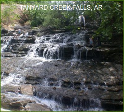
TOWNS | BENTONVILLE | LAT, LON (PARKING AREA) | lat=36.47206, lon=-94.26167(source: map) (accuracy: approximate) | LINK TO GOOGLE MAP
STATE | AR |
WATER | Tanyard Creek |
TYPE | Falls |
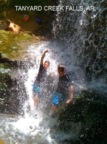
DESCRIPTION | From a visitor: "Is in Bella Vista, AR. It is so beautiful, and water is warm enough to enjoy. Bring a picnic lunch. Plus there are plenty of hiking trails to enjoy also." |
AREAS | Tanyard Creek Nature Trail |
SANCTION | Unofficial |
FEE | Unknown |
FACILITIES |
Unknown |
ACTIVITIES | Water play, swimming |
PHONE | None |
CAMPING | None at site |
BATHING SUITS | Required |
DIRECTIONS | From Bentonville, take I-540 north (becomes RT 71) to the Town Center Exit then take RT 340 west. Watch for the lake Windsor Dam on your left. Near the dam, turn east (left) on Westford Lane (also called "Nature Trail Lane") then right into the parking lot. Take the Tanyard Creek Nature Trail which leads off from the Pavilion to the right. It is an easy walk which will take you along the creek, over a swinging bridge, past bluffs, and up close to the beautiful waterfall.
|
CONFIDENCE | Pretty confident |
VERIFIED | No |
DATE UPDATED | 12/2012 | |
|---|
This swimming hole listing is by www.swimmingholes.org
|
TOWNS | FAYETTEVILLE, WEST FORK |
STATE | AR |
WATER | West Fork White River |
TYPE | River |
DESCRIPTION | Swimming holes in river. For details, see DIRECTIONS below. |
AREAS | Varies-see below |
SANCTION | Unofficial |
FEE | None |
FACILITIES |
Unknown |
ACTIVITIES | Swimming, jumping |
PHONE | None |
CAMPING | At Devil's Den State Park, southwest of here. |
BATHING SUITS | Required |
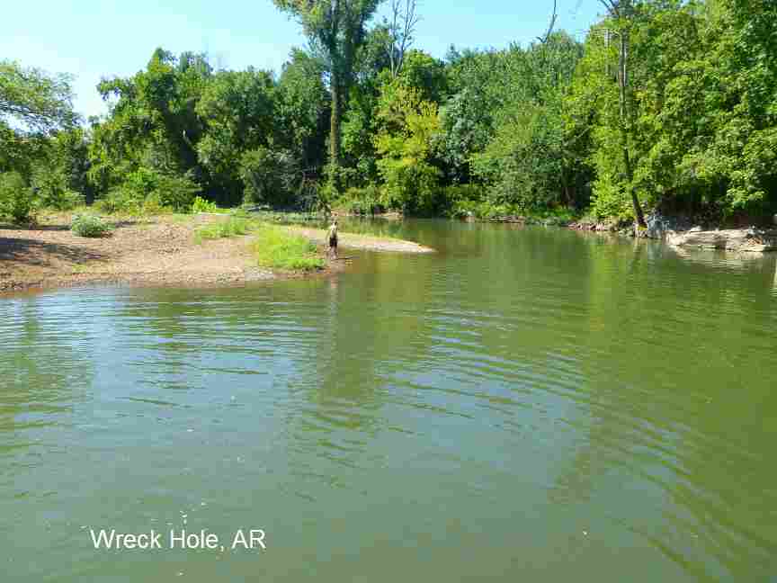
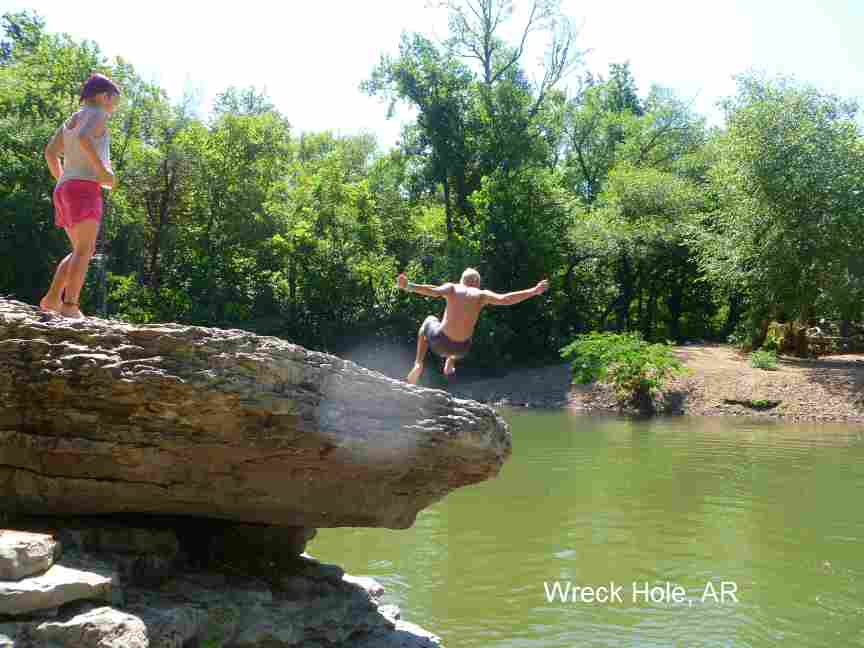
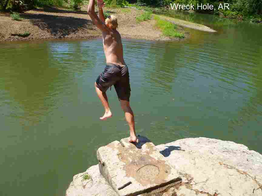
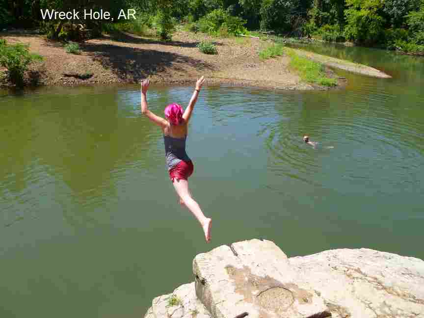
DIRECTIONS | From Fayetteville, go south on I-540 a short distance to the exit for RT 170 at the town of West Fork. Then: | WRECK HOLE [WREC]: Hole where the West Fork White River parallels railroad tracks through town. PHOTO , PHOTO , PHOTO , PHOTO .This report from a visitor in 2010: "This is truly a magnificent swimming hole. One of the best I've been to in.. well.... forever. It's spring fed, and as such stays cool even in the extremely hot weather. The water was clear enough that you could see the bottom in most places, and there is a huge rock that juts out over the water that you can jump off of. It's about 10 feet down to the water and it wore my kids out for three days straight. We kept going back for more. It's also mostly unused, as we were there a total of 14 hours or so over three days and only ever saw four other people, all of whom were very nice. This place is a must visit for those looking for a clean, cool place to get some relief from the heat and have some fun." This report from a local in 2012; "It's a nice one - was there with my six year old and wished I had tried to approach from the other side of the river, where there is access from trails going off from a park where there is a softball field and lots of parking. The access from Campbell road gets to a high bank with deep water only ( a boulder you can jump from and a rope swing that looked like you'd have to be a daredevil to use), and the trails to a shallower more kid friendly spot are a little dangerous. We went at about ten in the morning on a weekday and there wasn't anyone else there. There was evidence of partying, though, trash and cans and cigarette butts. Next time we go we will make sure to bring an extra trash bag and clean it up. I think that the kids must use it at night even though it is on city land and thus against the law. I didn't see any glass, though, the locals care at least that much I would like to think. To get here, take RT 170 east into the town of West Fork. Right after the curve in the road, go east (left) on Main Street. Go one block east on Main Street, then go north (left) on Campbell Rd.. You will reach a Y in the road where Cemetery Rd. forks off to the left - stay to the right and keep going on Campbell Rd.. Just over the hill from here you will see two small gravel turnouts on either side of the road. At the gravel turnouts there is a small foot trail that crosses the railroad tracks and descends to the swimming hole. If you get to the quarry on the left side of the road you've gone too far. LAT, LON: lat=35.933202, lon=-94.189766(source: map) (accuracy:approximate), LINK TO GOOGLE MAP. Very confident. Verified by another. Updated 8/10. RIVERSIDE PARK [RIVS]: A low dam across the West Fork of the White River creates a small reservoir for municipal water with a park on one side and limestone cliffs for jumping on the other. The swimming hole is very lively in the summer with lots of children & families. LAT, LON :lat=35.92753, lon=-94.18397(source: DeLorme) (accuracy:approximate) LINK TO GOOGLE MAP. Has park benches, portable johns, picnic shelter, walking trails. Swimming, canoeing (at high water upstream or down) jumping. To get here go east on RT 170 though West Fork then take a right just before the bridge over the West Fork White River into park parking lot. Very confident. Not verified. Updated 12/28/2006. CEDAR FLATS [CEDA]: Unofficial swimming place southwest of West Fork, just outside of Devil's Den State Park. This report from a visitor in 8/10: "I was referred here by a kid working at the cafe in Devils Den State Park. He said the water was a little low this time of year and he was right. Still, my daughters loved swimming there and it only takes two minutes to get there from the park. Despite not being spring fed the water was cool and clear. Has a nice little rope swing. Large rock shelves that you can perch on. Looks like this place would be truly magnificent when full of water. There are lots of camping areas here, though they were all pretty trashy. Looks like the locals don't pick up after themselves as there are a lot of empty beer cans and whatnot scattered about. Otherwise it would be a beautiful place to camp, with smooth dirt areas for tents and lots of fire pits already dug and rocked. It's up under the canopy of huge cedar trees so lots of shade and nice cool breezes blowing through the branches. No facilities of any kind." LAT, LON: lat=35.77012, lon=-94.27518(source: map) (accuracy:general area) LINK TO GOOGLE MAP. To get here from West Fork, take RT 170 to the west then south and follow the signs to Devil's Den State Park. In the park, take the gravel road past Campground E. Proceed out of the park and over the single lane bridge (Ellis Creek?). Take the two next left turns off this road (dirt drives, not paved). to the Cedar Flats swimming hole. Verified by another. Updated 8/10.
CONFIDENCE | Varies- see above |
VERIFIED | Varies- see above |
DATE UPDATED | 12/2012 | |
|---|
HOME