
ALBERTA |
|---|
Click here to see the home page and
learn about swimming holes in other states
This swimming hole listing is by www.swimmingholes.org
|
| ||
|---|---|---|---|
| TOWNS | CALGARY, CREMONA, WATER VALLEY | ||
| LAT, LON | lat=51.5897744311, lon=-115.168707254, (source: park web site) (accuracy: approximate) LINK TO GOOGLE MAP | ||
| PROVINCE | AB | ||
| WATER | Burnt Timber Creek | ||
| TYPE | Creek | ||
| DESCRIPTION | Swimming, tubing in the Burnt Timber creek in Burnt Timber Provincial Park. | ||
| AREAS | Burnt Timber Provincial Park | ||
| SANCTION | Official | ||
| FEE | Unknown | ||
| FACILITIES | Unknown | ||
| ACTIVITIES | Swimming, tubing | ||
| PHONE | 403-637-2198 | ||
| CAMPING | At site. | ||
| BATHING SUITS | Required | ||
| DIRECTIONS | It is approximately 1.5 hours northwest of Calgary. From Calgary, go west on RT 1 about 15 miles then north on RT 22 through Cochrane toward Cremona. About 3 miles BEFORE (south of) Cremona, take the Water Valley turnoff west. From the turnoff it is about 17 miles from the 4-way-stop in Water Valley, turning north RT 940 (the Forestry Trunk Road) and heading 15 mi north. | ||
| CONFIDENCE | Pretty confident | ||
| VERIFIED | No | ||
| DATE UPDATED | 1/2011 |
This swimming hole listing is by www.swimmingholes.org
|
| ||
|---|---|---|---|
| TOWNS | CALGARY, BANFF | ||
| LAT, LON | lat=51.21328, lon=-115.53420, (source: map) (accuracy: approximate) LINK TO GOOGLE MAP | ||
| PROVINCE | AB | ||
| WATER | Cascade Ponds | ||
| TYPE | Creek | ||
| DESCRIPTION | Swimming place in pond at picnic area. The water is shallow, and there are plenty of grassy areas it's perfect for families with young children. | ||
| AREAS | Cascade Ponds Picnic Area | ||
| SANCTION | Official | ||
| FEE | Unknown | ||
| FACILITIES | Bathroom, picnic tables | ||
| ACTIVITIES | Swimming | ||
| PHONE | none | ||
| CAMPING | none at site. | ||
| BATHING SUITS | Customary | ||
| DIRECTIONS | From Calgary, drive West on RT 1 until the 1st entrance into Banff/Lake Minnewanka. Stay to the right (North) then take your first right into the well signed Cascade Ponds parking lot. | ||
| CONFIDENCE | Very confident | ||
| VERIFIED | No | ||
| DATE UPDATED | 1/2011 |
This swimming hole listing is by www.swimmingholes.org
|
| |
|---|---|---|
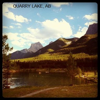
| TOWNS | CANMORE | |
| LAT, LON | lat=51.076082, lon=-115.373463, (source: measured by another) (accuracy: approximate) LINK TO GOOGLE MAP | |
| PROVINCE | AB | |
| WATER | Lake | |
| TYPE | Glacier lake | |
| DESCRIPTION | Swimming with a stunning view of the Canadian rockies. | |
| AREAS | Quarry Lake Park | |
| SANCTION | Official | |
| FEE | None | |
| FACILITIES | None | |
| ACTIVITIES | Swimming | |
| PHONE | None | |
| CAMPING | None at site. | |
| BATHING SUITS | Customary | |
| DIRECTIONS | From downtown Canmore, follow signs to the Nordic Centre. Cross the Bow River and head up Rundle Dr/Hwy 742. Turn left onto Three Sisters Rd/Hwy 742 and stay on that road as it becomes Three Sisters Dr and then Spray Lakes Rd. There will be a sign for the quarry and a parking lot. Walk 5minutes along the path, very clearly marked, to the lake | |
| CONFIDENCE | Very confident | |
| VERIFIED | By another | |
| DATE UPDATED | 11/2012 |
HOME